NOAA GOES-R Series Geostationary Lightning Mapper (GLM) Level 2 Lightning Detection: Events, Groups, and Flashes
- referenceSystemInfo
- identificationInfo
- contentInfo
- distributionInfo
- dataQualityInfo
- dataQualityInfo
- metadataMaintenance
(MI_Metadata)
fileIdentifier: gov.noaa.ncdc:C01527
language: eng; USA
characterSet: (MD_CharacterSetCode) utf8
hierarchyLevel: (MD_ScopeCode) dataset
contact: (CI_ResponsibleParty)
organisationName: NOAA National Centers for Environmental Information
contactInfo: (CI_Contact)
address: (CI_Address)
electronicMailAddress: ncei.info@noaa.gov
onlineResource: (CI_OnlineResource)
linkage: https://www.ncei.noaa.gov/contact
name: NCEI Contact Information
description: Information for contacts at NCEI.
function: (CI_OnLineFunctionCode) information
role: (CI_RoleCode) pointOfContact
dateStamp: 2023-10-19
metadataStandardName: ISO 19115-2 Geographic Information - Metadata - Part 2: Extensions for Imagery and Gridded Data
metadataStandardVersion: ISO 19115-2:2009(E)
return to top
referenceSystemInfo: (MD_ReferenceSystem)
referenceSystemIdentifier: (RS_Identifier)
authority: (CI_Citation)
title: EPSG Geodetic Parameter Dataset Registry
date: (CI_Date)
date: 2008-11-12
dateType: (CI_DateTypeCode) publication
citedResponsibleParty: (CI_ResponsibleParty)
organisationName: International Association of Oil and Gas Producers (OGP) Geomatics Committee
contactInfo: (CI_Contact)
onlineResource: (CI_OnlineResource)
linkage: http://www.epsg-registry.org/
applicationProfile: Data Search Application
name: EPSG Geodetic Parameter Dataset Registry Application
description: Interface to the EPSG Geodetic Parameter Dataset Registry
function: (CI_OnLineFunctionCode) search
role: (CI_RoleCode) custodian
citedResponsibleParty: (CI_ResponsibleParty)
organisationName: International Association of Oil and Gas Producers (OGP) Geomatics Committee
contactInfo: (CI_Contact)
onlineResource: (CI_OnlineResource)
linkage: http://www.epsg-registry.org/export.htm?gml=urn:ogc:def:crs:EPSG::4326
applicationProfile: Download
name: Coordinate Reference System data in GML
description: Coordinate Reference System data in GML
function: (CI_OnLineFunctionCode) download
role: (CI_RoleCode) custodian
code: urn:ogc:def:crs:EPSG::4326
version: (unknown)
return to top
identificationInfo: (MD_DataIdentification)
citation: (CI_Citation)
title: NOAA GOES-R Series Geostationary Lightning Mapper (GLM) Level 2 Lightning Detection: Events, Groups, and Flashes
alternateTitle: GLM-L2-LCFA
date: (CI_Date)
date: 2018-01-19
dateType: (CI_DateTypeCode) publication
edition: (missing)
identifier: (MD_Identifier)
code:
Anchor: DOI doi:10.7289/V5KH0KK6
identifier: (MD_Identifier)
code: gov.noaa.ncdc:C01527
identifier: (MD_Identifier)
code: GLM-L2-LCFA
identifier: (MD_Identifier)
code: gov.noaa.class:GLML2LCFA
citedResponsibleParty: (CI_ResponsibleParty)
organisationName: NOAA National Centers for Environmental Information
role: (CI_RoleCode) publisher
citedResponsibleParty: (CI_ResponsibleParty)
organisationName: GOES-R Algorithm Working Group
role: (CI_RoleCode) principalInvestigator
citedResponsibleParty: (CI_ResponsibleParty)
organisationName: GOES-R Algorithm Working Group
role: (CI_RoleCode) author
citedResponsibleParty: (CI_ResponsibleParty)
organisationName: GOES-R Series Program
role: (CI_RoleCode) resourceProvider
citedResponsibleParty: (CI_ResponsibleParty)
organisationName: GOES-R Series Program
role: (CI_RoleCode) author
presentationForm: (CI_PresentationFormCode) imageDigital
abstract: The Geostationary Lightning Mapper Level 2 Lightning Detection product contains a list of lightning flashes, and their constituent groups and events. The definition of and relationship among flashes, groups, and events are governed by the following spatial and temporal characteristics: An event represents the signal detected from the cloud top associated with a lightning emission in an individual sensor pixel for a 2ms integration period; A group represents the events detected in adjacent sensor pixels for the same integration period as an event; A flash represents a series of measurements constrained by temporal and spatial extent thresholds that are associated with one or more groups. The parent, child relationship among specific flashes, groups, and events is stored in the product. Data for each flash includes an energy-weighted centroid latitude, longitude location, time span of occurrence, amount of radiant energy, and coverage area. Data for each group includes an energy-weighted centroid latitude, longitude location, mean time of occurrence, amount of radiant energy, and coverage area. Data for each event includes a latitude, longitude location, time of occurrence, and amount of radiant energy. The product includes data quality information for each flash and group. A Lightning Detection product file contains a set of flashes, and its constituent groups and events for a 20 second period. The units of measure for the flash, group, and event radiant energy values is Joules. The units of measure for the flash and group coverage areas is square meters.
purpose: Currently weather forecasters can use lightning data provided by a surface-based network to help "nowcast" severe weather. This is a valuable tool; however, it only has the capability of detecting cloud-to-ground flashes. The GOES-R satellites will have the capability to detect both cloud-to-ground and inter-cloud lightning, through use of the Geostationary Lightning Mapper (GLM). This will help severe weather forecasters identify thunderstorms which are rapidly intensifying, and enable them to issue accurate and timely severe thunderstorm and tornado warnings.
status: (MD_ProgressCode) onGoing
pointOfContact: (CI_ResponsibleParty)
individualName: Customer Engagement Branch
organisationName: DOC/NOAA/NESDIS/NCEI > National Centers for Environmental Information, NESDIS, NOAA, U.S. Department of Commerce
contactInfo: (CI_Contact)
address: (CI_Address)
electronicMailAddress: ncei.sat.info@noaa.gov
role: (CI_RoleCode) pointOfContact
resourceMaintenance: (MD_MaintenanceInformation)
maintenanceAndUpdateFrequency: (MD_MaintenanceFrequencyCode) continual
graphicOverview: (MD_BrowseGraphic)
fileName: https://www.ncei.noaa.gov/pub/data/metadata/images/C01527.jpg
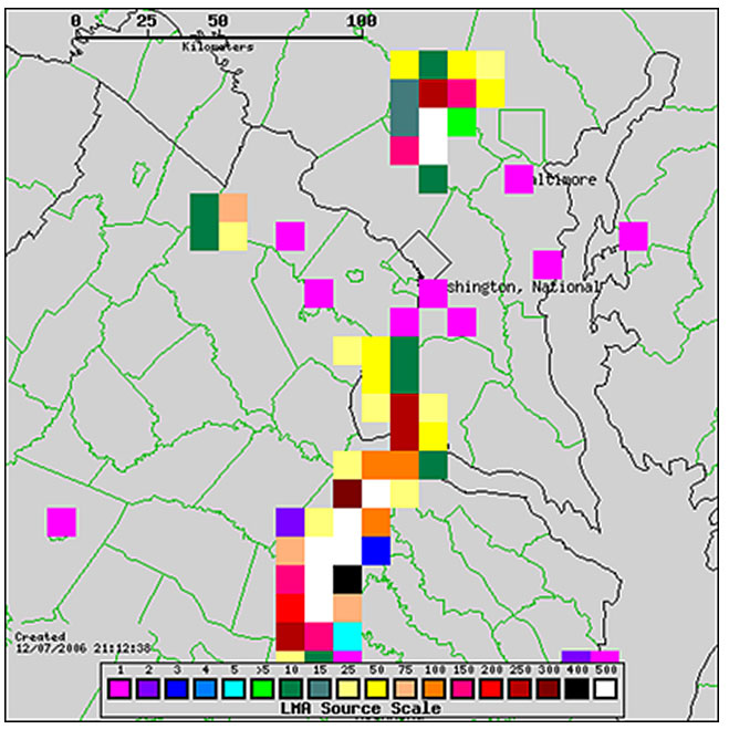
fileDescription: Example display of GLM proxy lightning data centered over the Sterling, Virginia NWS office.
fileType: JPEG
descriptiveKeywords: (MD_Keywords)
keyword: Earth Science > Atmosphere > Atmospheric Electricity > Lightning
type: (MD_KeywordTypeCode) theme
thesaurusName: (CI_Citation)
title: Global Change Master Directory (GCMD) Science Keywords
date: (CI_Date)
date: 2018
dateType: (CI_DateTypeCode) revision
edition: Version 8.6
citedResponsibleParty: (CI_ResponsibleParty)
organisationName: Global Change Data Center, Science and Exploration Directorate, Goddard Space Flight Center (GSFC) National Aeronautics and Space Administration (NASA)
contactInfo: (CI_Contact)
onlineResource: (CI_OnlineResource)
linkage: https://earthdata.nasa.gov/about/gcmd/global-change-master-directory-gcmd-keywords
protocol: HTTPS
applicationProfile: Web Browser
name: Global Change Master Directory (GCMD) Keywords
description: The information provided on this page seeks to define how the GCMD Keywords are structured, used and accessed. It also provides information on how users can participate in the further development of the keywords.
function: (CI_OnLineFunctionCode) information
role: (CI_RoleCode) publisher
descriptiveKeywords: (MD_Keywords)
keyword: Geographic Region > Equatorial
keyword: Geographic Region > Mid-Latitude
keyword: Geographic Region > Tropics
keyword: Geographic Region > Northern Hemisphere
keyword: Geographic Region > Southern Hemisphere
keyword: Geographic Region > Western Hemisphere
keyword: Continent > North America > United States Of America
keyword: Continent > South America
keyword: Continent > North America > Central America
keyword: Ocean > Atlantic Ocean
keyword: Ocean > Pacific Ocean
type: (MD_KeywordTypeCode) place
thesaurusName: (CI_Citation)
title: Global Change Master Directory (GCMD) Location Keywords
date: (CI_Date)
date: 2018
dateType: (CI_DateTypeCode) revision
edition: Version 8.6
citedResponsibleParty: (CI_ResponsibleParty)
organisationName: Global Change Data Center, Science and Exploration Directorate, Goddard Space Flight Center (GSFC) National Aeronautics and Space Administration (NASA)
contactInfo: (CI_Contact)
onlineResource: (CI_OnlineResource)
linkage: https://earthdata.nasa.gov/about/gcmd/global-change-master-directory-gcmd-keywords
protocol: HTTPS
applicationProfile: Web Browser
name: Global Change Master Directory (GCMD) Keywords
description: The information provided on this page seeks to define how the GCMD Keywords are structured, used and accessed. It also provides information on how users can participate in the further development of the keywords.
function: (CI_OnLineFunctionCode) information
role: (CI_RoleCode) publisher
descriptiveKeywords: (MD_Keywords)
keyword: Vertical Location > Troposphere
keyword: Vertical Location > Land Surface
type: (MD_KeywordTypeCode) stratum
thesaurusName: (CI_Citation)
title: Global Change Master Directory (GCMD) Location Keywords
date: (CI_Date)
date: 2018
dateType: (CI_DateTypeCode) revision
edition: Version 8.6
citedResponsibleParty: (CI_ResponsibleParty)
organisationName: Global Change Data Center, Science and Exploration Directorate, Goddard Space Flight Center (GSFC) National Aeronautics and Space Administration (NASA)
contactInfo: (CI_Contact)
onlineResource: (CI_OnlineResource)
linkage: https://earthdata.nasa.gov/about/gcmd/global-change-master-directory-gcmd-keywords
protocol: HTTPS
applicationProfile: Web Browser
name: Global Change Master Directory (GCMD) Keywords
description: The information provided on this page seeks to define how the GCMD Keywords are structured, used and accessed. It also provides information on how users can participate in the further development of the keywords.
function: (CI_OnLineFunctionCode) information
role: (CI_RoleCode) publisher
descriptiveKeywords: (MD_Keywords)
keyword: GOES > Geostationary Operational Environmental Satellites
type: (MD_KeywordTypeCode) project
thesaurusName: (CI_Citation)
title: Global Change Master Directory (GCMD) Project Keywords
date: (CI_Date)
date: 2018
dateType: (CI_DateTypeCode) revision
edition: Version 8.6
citedResponsibleParty: (CI_ResponsibleParty)
organisationName: Global Change Data Center, Science and Exploration Directorate, Goddard Space Flight Center (GSFC) National Aeronautics and Space Administration (NASA)
contactInfo: (CI_Contact)
onlineResource: (CI_OnlineResource)
linkage: https://earthdata.nasa.gov/about/gcmd/global-change-master-directory-gcmd-keywords
protocol: HTTPS
applicationProfile: Web Browser
name: Global Change Master Directory (GCMD) Keywords
description: The information provided on this page seeks to define how the GCMD Keywords are structured, used and accessed. It also provides information on how users can participate in the further development of the keywords.
function: (CI_OnLineFunctionCode) information
role: (CI_RoleCode) publisher
descriptiveKeywords: (MD_Keywords)
keyword: GLM > Geostationary Lightning Mapper
type: (MD_KeywordTypeCode) instrument
thesaurusName: (CI_Citation)
title: Global Change Master Directory (GCMD) Instrument Keywords
date: (CI_Date)
date: 2018
dateType: (CI_DateTypeCode) revision
edition: Version 8.6
citedResponsibleParty: (CI_ResponsibleParty)
organisationName: Global Change Data Center, Science and Exploration Directorate, Goddard Space Flight Center (GSFC) National Aeronautics and Space Administration (NASA)
contactInfo: (CI_Contact)
onlineResource: (CI_OnlineResource)
linkage: https://earthdata.nasa.gov/about/gcmd/global-change-master-directory-gcmd-keywords
protocol: HTTPS
applicationProfile: Web Browser
name: Global Change Master Directory (GCMD) Keywords
description: The information provided on this page seeks to define how the GCMD Keywords are structured, used and accessed. It also provides information on how users can participate in the further development of the keywords.
function: (CI_OnLineFunctionCode) information
role: (CI_RoleCode) publisher
descriptiveKeywords: (MD_Keywords)
keyword: GOES-16 > Geostationary Operational Environmental Satellite 16
keyword: GOES-17 > Geostationary Operational Environmental Satellite 17
keyword: GOES-18 > Geostationary Operational Environmental Satellite 18
type: (MD_KeywordTypeCode) platform
thesaurusName: (CI_Citation)
title: Global Change Master Directory (GCMD) Platform Keywords
date: (CI_Date)
date: 2018
dateType: (CI_DateTypeCode) revision
edition: Version 8.6
citedResponsibleParty: (CI_ResponsibleParty)
organisationName: Global Change Data Center, Science and Exploration Directorate, Goddard Space Flight Center (GSFC) National Aeronautics and Space Administration (NASA)
contactInfo: (CI_Contact)
onlineResource: (CI_OnlineResource)
linkage: https://earthdata.nasa.gov/about/gcmd/global-change-master-directory-gcmd-keywords
protocol: HTTPS
applicationProfile: Web Browser
name: Global Change Master Directory (GCMD) Keywords
description: The information provided on this page seeks to define how the GCMD Keywords are structured, used and accessed. It also provides information on how users can participate in the further development of the keywords.
function: (CI_OnLineFunctionCode) information
role: (CI_RoleCode) publisher
descriptiveKeywords: (MD_Keywords)
keyword: 10 km - < 50 km or approximately .09 degree - < .5 degree
type: (MD_KeywordTypeCode) dataResolution
thesaurusName: (CI_Citation)
title: Global Change Master Directory (GCMD) Horizontal Data Resolution Keywords
date: (CI_Date)
date: 2018
dateType: (CI_DateTypeCode) revision
edition: Version 8.6
citedResponsibleParty: (CI_ResponsibleParty)
organisationName: Global Change Data Center, Science and Exploration Directorate, Goddard Space Flight Center (GSFC) National Aeronautics and Space Administration (NASA)
contactInfo: (CI_Contact)
onlineResource: (CI_OnlineResource)
linkage: https://earthdata.nasa.gov/about/gcmd/global-change-master-directory-gcmd-keywords
protocol: HTTPS
applicationProfile: Web Browser
name: Global Change Master Directory (GCMD) Keywords
description: The information provided on this page seeks to define how the GCMD Keywords are structured, used and accessed. It also provides information on how users can participate in the further development of the keywords.
function: (CI_OnLineFunctionCode) information
role: (CI_RoleCode) publisher
descriptiveKeywords: (MD_Keywords)
keyword: < 1 second
type: (MD_KeywordTypeCode) dataResolution
thesaurusName: (CI_Citation)
title: Global Change Master Directory (GCMD) Temporal Data Resolution Keywords
date: (CI_Date)
date: 2018
dateType: (CI_DateTypeCode) revision
edition: Version 8.6
citedResponsibleParty: (CI_ResponsibleParty)
organisationName: Global Change Data Center, Science and Exploration Directorate, Goddard Space Flight Center (GSFC) National Aeronautics and Space Administration (NASA)
contactInfo: (CI_Contact)
onlineResource: (CI_OnlineResource)
linkage: https://earthdata.nasa.gov/about/gcmd/global-change-master-directory-gcmd-keywords
protocol: HTTPS
applicationProfile: Web Browser
name: Global Change Master Directory (GCMD) Keywords
description: The information provided on this page seeks to define how the GCMD Keywords are structured, used and accessed. It also provides information on how users can participate in the further development of the keywords.
function: (CI_OnLineFunctionCode) information
role: (CI_RoleCode) publisher
descriptiveKeywords: (MD_Keywords)
keyword: DOC/NOAA/NESDIS/NCDC > National Climatic Data Center, NESDIS, NOAA, U.S. Department of Commerce
keyword: DOC/NOAA/NESDIS/NCEI > National Centers for Environmental Information, NESDIS, NOAA, U.S. Department of Commerce
keyword: DOC/NOAA/NESDIS/STAR > Center for Satellite Applications and Research, NESDIS, NOAA, U.S. Department of Commerce
keyword: DOC/NOAA/NESDIS/OSPO > Office of Satellite and Product Operations, NESDIS, NOAA, U.S. Department of Commerce
type: (MD_KeywordTypeCode) dataCentre
thesaurusName: (CI_Citation)
title: Global Change Master Directory (GCMD) Data Center Keywords
date: (CI_Date)
date: 2018
dateType: (CI_DateTypeCode) revision
edition: Version 8.6
citedResponsibleParty: (CI_ResponsibleParty)
organisationName: Global Change Data Center, Science and Exploration Directorate, Goddard Space Flight Center (GSFC) National Aeronautics and Space Administration (NASA)
contactInfo: (CI_Contact)
onlineResource: (CI_OnlineResource)
linkage: https://earthdata.nasa.gov/about/gcmd/global-change-master-directory-gcmd-keywords
protocol: HTTPS
applicationProfile: Web Browser
name: Global Change Master Directory (GCMD) Keywords
description: The information provided on this page seeks to define how the GCMD Keywords are structured, used and accessed. It also provides information on how users can participate in the further development of the keywords.
function: (CI_OnLineFunctionCode) information
role: (CI_RoleCode) publisher
descriptiveKeywords: (MD_Keywords)
keyword: gov.noaa.class:GRGLMPROD
type: (MD_KeywordTypeCode) project
descriptiveKeywords: (MD_Keywords)
keyword: GLM-L2-LCFA
type: (MD_KeywordTypeCode) project
thesaurusName: (CI_Citation)
title: NOAA STAR Central Data Repository (SCDR) Names
date: (inapplicable)
resourceConstraints: (MD_Constraints)
useLimitation: For a list of use limitations of this dataset, see the product README and Algorithm Theoretical Basis Document (ATBD).
resourceConstraints: (MD_LegalConstraints)
useConstraints: (MD_RestrictionCode) otherRestrictions
otherConstraints: Cite as: GOES-R Algorithm Working Group and GOES-R Series Program, (2018): NOAA GOES-R Series Geostationary Lightning Mapper (GLM) Level 2 Lightning Detection: Events, Groups, and Flashes. [indicate subset used]. NOAA National Centers for Environmental Information. doi:10.7289/V5KH0KK6. [access date].
resourceConstraints: (MD_LegalConstraints)
accessConstraints: (MD_RestrictionCode) otherRestrictions
otherConstraints: Distribution liability: NOAA and NCEI make no warranty, expressed or implied, regarding these data, nor does the fact of distribution constitute such a warranty. NOAA and NCEI cannot assume liability for any damages caused by any errors or omissions in these data. If appropriate, NCEI can only certify that the data it distributes are an authentic copy of the records that were accepted for inclusion in the NCEI archives.
resourceConstraints: (MD_LegalConstraints)
useConstraints: (MD_RestrictionCode) otherRestrictions
otherConstraints: Use liability: NOAA and NCEI cannot provide any warranty as to the accuracy, reliability, or completeness of furnished data. Users assume responsibility to determine the usability of these data. The user is responsible for the results of any application of this data for other than its intended purpose.
aggregationInfo: (MD_AggregateInformation)
aggregateDataSetName: (CI_Citation)
title: Baseline Product - Lightning Detection: Events, Groups, and Flashes Webpage
date: (missing)
citedResponsibleParty: (CI_ResponsibleParty)
organisationName: (missing)
contactInfo: (CI_Contact)
onlineResource: (CI_OnlineResource)
linkage: https://www.goes-r.gov/products/baseline-lightning-detection.html
applicationProfile: Web Browser
name: Baseline Product - Lightning Detection: Events, Groups, and Flashes Webpage
description: Webpage containing information and documentation on the dataset.
function: (CI_OnLineFunctionCode) information
role: (missing)
associationType: (DS_AssociationTypeCode) crossReference
initiativeType: (DS_InitiativeTypeCode) userGuide
aggregationInfo: (MD_AggregateInformation)
aggregateDataSetName: (CI_Citation)
title: GOES Operational Status - NOAA Office of Satellite and Product Operations
date: (missing)
citedResponsibleParty: (CI_ResponsibleParty)
organisationName: (missing)
contactInfo: (CI_Contact)
onlineResource: (CI_OnlineResource)
linkage: https://www.ospo.noaa.gov/Operations/GOES/status.html
applicationProfile: Web Browser
name: GOES Operational Status - NOAA Office of Satellite and Product Operations
description: GOES spacecraft status page.
function: (CI_OnLineFunctionCode) information
role: (missing)
associationType: (DS_AssociationTypeCode) crossReference
initiativeType: (DS_InitiativeTypeCode) userGuide
aggregationInfo: (MD_AggregateInformation)
aggregateDataSetName: (CI_Citation)
title: The GOES-R Geostationary Lightning Mapper (GLM).
date: (CI_Date)
date: 2013-03-01
dateType: (CI_DateTypeCode) publication
identifier: (MD_Identifier)
code: doi:10.1016/j.atmosres.2013.01.006
citedResponsibleParty: (CI_ResponsibleParty)
organisationName: ELSEVIER > Elsevier Science Inc.
role: (CI_RoleCode) publisher
citedResponsibleParty: (CI_ResponsibleParty)
organisationName: (missing)
contactInfo: (CI_Contact)
onlineResource: (CI_OnlineResource)
linkage: https://doi.org/10.1016/j.atmosres.2013.01.006
protocol: HTTPS
applicationProfile: Web Browser
name: Journal article published May 2013 by Elsevier (Atmospheric Research)
description: Goodman, S., Blakeslee, R., et al, (2013), The GOES-R Geostationary Lightning Mapper (GLM), Atm. Res., 125, 34–49, doi:10.1016/j.atmosres.2013.01.006.
function: (CI_OnLineFunctionCode) information
role: (missing)
associationType: (DS_AssociationTypeCode) crossReference
initiativeType: (DS_InitiativeTypeCode) sciencePaper
aggregationInfo: (MD_AggregateInformation)
aggregateDataSetName: (CI_Citation)
title: GOES-R Program Document Library
date: (missing)
citedResponsibleParty: (CI_ResponsibleParty)
organisationName: (missing)
contactInfo: (CI_Contact)
onlineResource: (CI_OnlineResource)
linkage: https://www.goes-r.gov/resources/docs.html
applicationProfile: Web Browser
name: GOES-R Program Document Library
description: Webpage with product algorithm, users guides, and education and outreach materials.
function: (CI_OnLineFunctionCode) information
role: (missing)
associationType: (DS_AssociationTypeCode) crossReference
initiativeType: (DS_InitiativeTypeCode) userGuide
spatialRepresentationType: (MD_SpatialRepresentationTypeCode) grid
spatialResolution: (MD_Resolution)
distance:
Distance: 8000
language: eng; USA
topicCategory: (MD_TopicCategoryCode) climatologyMeteorologyAtmosphere
extent: (EX_Extent)
geographicElement: (EX_GeographicBoundingBox)
extentTypeCode: 1
westBoundLongitude: -141.56
eastBoundLongitude: -8.44
southBoundLatitude: -66.56
northBoundLatitude: 66.56
geographicElement: (EX_GeographicBoundingBox)
extentTypeCode: 1
westBoundLongitude: -203.56
eastBoundLongitude: -70.44
southBoundLatitude: -66.56
northBoundLatitude: 66.56
temporalElement: (EX_TemporalExtent)
extent:
TimePeriod:
description: ground condition
beginPosition: 2017-07-05
endPosition:
timeInterval: 1
return to top
contentInfo: (MI_CoverageDescription)
attributeDescription:
RecordType: OR_GLM-L2-LCFA_G16_sYYYYDDDHHMMSS_eYYYYDDDHHMMSS_cYYYYDDDHHMMSS.nc
contentType: (MD_CoverageContentTypeCode) physicalMeasurement
dimension: (MD_Band)
sequenceIdentifier:
MemberName:
aName: event_id
attributeType:
TypeName:
aName: int
descriptor: product-unique lightning event identifier
units: http://example.org/someUnitsDictionary.xml#1
dimension: (MD_Band)
sequenceIdentifier:
MemberName:
aName: event_time_offset
attributeType:
TypeName:
aName: short
descriptor: GLM L2+ Lightning Detection: event's time of occurrence (time)
units: http://example.org/someUnitsDictionary.xml#milliseconds%20since%202018-02-07%2013%3A18%3A40.000
dimension: (MD_Band)
sequenceIdentifier:
MemberName:
aName: event_lat
attributeType:
TypeName:
aName: short
descriptor: GLM L2+ Lightning Detection: event latitude coordinate (latitude)
units: http://example.org/someUnitsDictionary.xml#degrees_north
dimension: (MD_Band)
sequenceIdentifier:
MemberName:
aName: event_lon
attributeType:
TypeName:
aName: short
descriptor: GLM L2+ Lightning Detection: event longitude coordinate (longitude)
units: http://example.org/someUnitsDictionary.xml#degrees_east
dimension: (MD_Band)
sequenceIdentifier:
MemberName:
aName: event_energy
attributeType:
TypeName:
aName: short
descriptor: GLM L2+ Lightning Detection: event radiant energy (lightning_radiant_energy)
units: http://example.org/someUnitsDictionary.xml#J
dimension: (MD_Band)
sequenceIdentifier:
MemberName:
aName: event_parent_group_id
attributeType:
TypeName:
aName: int
descriptor: product-unique lightning group identifier for one or more events
units: http://example.org/someUnitsDictionary.xml#1
dimension: (MD_Band)
sequenceIdentifier:
MemberName:
aName: group_id
attributeType:
TypeName:
aName: int
descriptor: product-unique lightning group identifier
units: http://example.org/someUnitsDictionary.xml#1
dimension: (MD_Band)
sequenceIdentifier:
MemberName:
aName: group_time_offset
attributeType:
TypeName:
aName: short
descriptor: GLM L2+ Lightning Detection: mean time of group's constituent events' times of occurrence (time)
units: http://example.org/someUnitsDictionary.xml#milliseconds%20since%202018-02-07%2013%3A18%3A40.000
dimension: (MD_Band)
sequenceIdentifier:
MemberName:
aName: group_lat
attributeType:
TypeName:
aName: float
descriptor: GLM L2+ Lightning Detection: group centroid (mean constituent event latitude weighted by their energies) latitude coordinate (latitude)
units: http://example.org/someUnitsDictionary.xml#degrees_north
dimension: (MD_Band)
sequenceIdentifier:
MemberName:
aName: group_lon
attributeType:
TypeName:
aName: float
descriptor: GLM L2+ Lightning Detection: group centroid (mean constituent event latitude weighted by their energies) longitude coordinate (longitude)
units: http://example.org/someUnitsDictionary.xml#degrees_east
dimension: (MD_Band)
sequenceIdentifier:
MemberName:
aName: group_area
attributeType:
TypeName:
aName: short
descriptor: GLM L2+ Lightning Detection: group area coverage (pixels containing at least one constituent event only)
units: http://example.org/someUnitsDictionary.xml#km2
dimension: (MD_Band)
sequenceIdentifier:
MemberName:
aName: group_energy
attributeType:
TypeName:
aName: short
descriptor: GLM L2+ Lightning Detection: group radiant energy (lightning_radiant_energy)
units: http://example.org/someUnitsDictionary.xml#J
dimension: (MD_Band)
sequenceIdentifier:
MemberName:
aName: group_parent_flash_id
attributeType:
TypeName:
aName: short
descriptor: product-unique lightning flash identifier for one or more groups
units: http://example.org/someUnitsDictionary.xml#1
dimension: (MD_Band)
sequenceIdentifier:
MemberName:
aName: group_quality_flag
attributeType:
TypeName:
aName: short
descriptor: GLM L2+ Lightning Detection: group data quality flags (status_flag)
units: http://example.org/someUnitsDictionary.xml#1
dimension: (MD_Band)
sequenceIdentifier:
MemberName:
aName: flash_id
attributeType:
TypeName:
aName: short
descriptor: product-unique lightning flash identifier
units: http://example.org/someUnitsDictionary.xml#1
dimension: (MD_Band)
sequenceIdentifier:
MemberName:
aName: flash_time_offset_of_first_event
attributeType:
TypeName:
aName: short
descriptor: GLM L2+ Lightning Detection: time of occurrence of first constituent event in flash (time)
units: http://example.org/someUnitsDictionary.xml#milliseconds%20since%202018-02-07%2013%3A18%3A40.000
dimension: (MD_Band)
sequenceIdentifier:
MemberName:
aName: flash_time_offset_of_last_event
attributeType:
TypeName:
aName: short
descriptor: GLM L2+ Lightning Detection: time of occurrence of last constituent event in flash (time)
units: http://example.org/someUnitsDictionary.xml#milliseconds%20since%202018-02-07%2013%3A18%3A40.000
dimension: (MD_Band)
sequenceIdentifier:
MemberName:
aName: flash_lat
attributeType:
TypeName:
aName: float
descriptor: GLM L2+ Lightning Detection: flash centroid (mean constituent event latitude weighted by their energies) latitude coordinate (latitude)
units: http://example.org/someUnitsDictionary.xml#degrees_north
dimension: (MD_Band)
sequenceIdentifier:
MemberName:
aName: flash_lon
attributeType:
TypeName:
aName: float
descriptor: GLM L2+ Lightning Detection: flash centroid (mean constituent event latitude weighted by their energies) longitude coordinate (longitude)
units: http://example.org/someUnitsDictionary.xml#degrees_east
dimension: (MD_Band)
sequenceIdentifier:
MemberName:
aName: flash_area
attributeType:
TypeName:
aName: short
descriptor: GLM L2+ Lightning Detection: flash area coverage (pixels containing at least one constituent event only)
units: http://example.org/someUnitsDictionary.xml#km2
dimension: (MD_Band)
sequenceIdentifier:
MemberName:
aName: flash_energy
attributeType:
TypeName:
aName: short
descriptor: GLM L2+ Lightning Detection: flash radiant energy (lightning_radiant_energy)
units: http://example.org/someUnitsDictionary.xml#J
dimension: (MD_Band)
sequenceIdentifier:
MemberName:
aName: flash_quality_flag
attributeType:
TypeName:
aName: short
descriptor: GLM L2+ Lightning Detection: flash data quality flags (status_flag)
units: http://example.org/someUnitsDictionary.xml#1
dimension: (MD_Band)
sequenceIdentifier:
MemberName:
aName: product_time
attributeType:
TypeName:
aName: double
descriptor: start time of observations associated with product (time)
units: http://example.org/someUnitsDictionary.xml#seconds%20since%202000-01-01%2012%3A00%3A00
dimension: (MD_Band)
sequenceIdentifier:
MemberName:
aName: product_time_bounds
attributeType:
TypeName:
aName: double
descriptor: start and end time of observations associated with product
dimension: (MD_Band)
sequenceIdentifier:
MemberName:
aName: lightning_wavelength
attributeType:
TypeName:
aName: float
descriptor: central wavelength for lightning data (sensor_band_central_radiation_wavelength)
units: http://example.org/someUnitsDictionary.xml#nm
dimension: (MD_Band)
sequenceIdentifier:
MemberName:
aName: lightning_wavelength_bounds
attributeType:
TypeName:
aName: float
descriptor: wavelength range lightning data (full width at half the maximum of the response function)
dimension: (MD_Band)
sequenceIdentifier:
MemberName:
aName: group_time_threshold
attributeType:
TypeName:
aName: float
descriptor: lightning group maximum time difference among lightning events in a group
units: http://example.org/someUnitsDictionary.xml#s
dimension: (MD_Band)
sequenceIdentifier:
MemberName:
aName: flash_time_threshold
attributeType:
TypeName:
aName: float
descriptor: lightning flash maximum time difference among lightning events in a flash
units: http://example.org/someUnitsDictionary.xml#s
dimension: (MD_Band)
sequenceIdentifier:
MemberName:
aName: lat_field_of_view
attributeType:
TypeName:
aName: float
descriptor: latitude coordinate for center of field of view (latitude)
units: http://example.org/someUnitsDictionary.xml#degrees_north
dimension: (MD_Band)
sequenceIdentifier:
MemberName:
aName: lat_field_of_view_bounds
attributeType:
TypeName:
aName: float
descriptor: latitude coordinates for north/south extent of field of view
dimension: (MD_Band)
sequenceIdentifier:
MemberName:
aName: goes_lat_lon_projection
attributeType:
TypeName:
aName: int
descriptor: GOES-R latitude / longitude projection
dimension: (MD_Band)
sequenceIdentifier:
MemberName:
aName: event_count
attributeType:
TypeName:
aName: int
descriptor: number of lightning events in product
units: http://example.org/someUnitsDictionary.xml#count
dimension: (MD_Band)
sequenceIdentifier:
MemberName:
aName: group_count
attributeType:
TypeName:
aName: int
descriptor: number of lightning groups in product
units: http://example.org/someUnitsDictionary.xml#count
dimension: (MD_Band)
sequenceIdentifier:
MemberName:
aName: flash_count
attributeType:
TypeName:
aName: int
descriptor: number of lightning flashes in product
units: http://example.org/someUnitsDictionary.xml#count
dimension: (MD_Band)
sequenceIdentifier:
MemberName:
aName: percent_navigated_L1b_events
attributeType:
TypeName:
aName: float
descriptor: after false event filtering, percent of lightning events navigated by instrument
units: http://example.org/someUnitsDictionary.xml#percent
dimension: (MD_Band)
sequenceIdentifier:
MemberName:
aName: yaw_flip_flag
attributeType:
TypeName:
aName: byte
descriptor: Flag indicating spacecraft is operating in yaw flip configuration
units: http://example.org/someUnitsDictionary.xml#1
dimension: (MD_Band)
sequenceIdentifier:
MemberName:
aName: nominal_satellite_subpoint_lat
attributeType:
TypeName:
aName: float
descriptor: nominal satellite subpoint latitude (platform latitude) (latitude)
units: http://example.org/someUnitsDictionary.xml#degrees_north
dimension: (MD_Band)
sequenceIdentifier:
MemberName:
aName: nominal_satellite_height
attributeType:
TypeName:
aName: float
descriptor: nominal satellite height above GRS 80 ellipsoid (platform altitude) (height_above_reference_ellipsoid)
units: http://example.org/someUnitsDictionary.xml#km
dimension: (MD_Band)
sequenceIdentifier:
MemberName:
aName: nominal_satellite_subpoint_lon
attributeType:
TypeName:
aName: float
descriptor: nominal satellite subpoint longitude (platform longitude) (longitude)
units: http://example.org/someUnitsDictionary.xml#degrees_east
dimension: (MD_Band)
sequenceIdentifier:
MemberName:
aName: lon_field_of_view
attributeType:
TypeName:
aName: float
descriptor: longitude coordinate for center of field of view (longitude)
units: http://example.org/someUnitsDictionary.xml#degrees_east
dimension: (MD_Band)
sequenceIdentifier:
MemberName:
aName: lon_field_of_view_bounds
attributeType:
TypeName:
aName: float
descriptor: longitude coordinates for west/east extent of field of view
dimension: (MD_Band)
sequenceIdentifier:
MemberName:
aName: percent_uncorrectable_L0_errors
attributeType:
TypeName:
aName: float
descriptor: percent data lost due to uncorrectable L0 errors
units: http://example.org/someUnitsDictionary.xml#percent
dimension: (MD_Band)
sequenceIdentifier:
MemberName:
aName: algorithm_dynamic_input_data_container
attributeType:
TypeName:
aName: int
descriptor: container for filenames of dynamic algorithm input data
dimension: (MD_Band)
sequenceIdentifier:
MemberName:
aName: processing_parm_version_container
attributeType:
TypeName:
aName: int
descriptor: container for processing parameter filenames
dimension: (MD_Band)
sequenceIdentifier:
MemberName:
aName: algorithm_product_version_container
attributeType:
TypeName:
aName: int
descriptor: container for algorithm package filename and product version
return to top
distributionInfo: (MD_Distribution)
distributor: (MD_Distributor)
distributorContact: (CI_ResponsibleParty)
organisationName: NOAA National Centers for Environmental Information
contactInfo: (CI_Contact)
address: (CI_Address)
electronicMailAddress: ncei.info@noaa.gov
onlineResource: (CI_OnlineResource)
linkage: https://www.ncei.noaa.gov/contact
name: NCEI Contact Information
description: Information for contacts at NCEI.
function: (CI_OnLineFunctionCode) information
role: (CI_RoleCode) distributor
distributionOrderProcess: (MD_StandardOrderProcess)
fees: In most cases, electronic downloads of the data are free. However, fees may apply for custom orders, data certifications, copies of analog materials, and data distribution on physical media.
orderingInstructions: Contact NCEI for other distribution options and instructions.
distributorFormat: (MD_Format)
name: NetCDF
version: 4
distributorTransferOptions: (MD_DigitalTransferOptions)
onLine: (CI_OnlineResource)
linkage: https://doi.org/10.7289/V5KH0KK6
protocol: HTTPS
applicationProfile: Landing Page
name: NCEI Dataset Landing Page
description: Landing page for the dataset.
function: (CI_OnLineFunctionCode) information
distributorTransferOptions: (MD_DigitalTransferOptions)
onLine: (CI_OnlineResource)
linkage: https://console.cloud.google.com/storage/browser/gcp-public-data-goes-16
protocol: HTTPS
applicationProfile: Download
name: GOES-16 Google Cloud Bucket Explorer (Region: US-multiple)
description: Browse view to explore the Google Cloud bucket for GOES-16. Data relevant to this can be found in folders with the prefix GLM-L2-LCFA.
function: (CI_OnLineFunctionCode) download
distributorTransferOptions: (MD_DigitalTransferOptions)
onLine: (CI_OnlineResource)
linkage: https://console.cloud.google.com/storage/browser/gcp-public-data-goes-18
protocol: HTTPS
applicationProfile: Download
name: GOES-18 Google Cloud Bucket Explorer (Region: US-multiple)
description: Browse view to explore the Google Cloud bucket for GOES-18. Data relevant to this can be found in folders with the prefix GLM-L2-LCFA.
function: (CI_OnLineFunctionCode) download
distributorTransferOptions: (MD_DigitalTransferOptions)
onLine: (CI_OnlineResource)
linkage: https://console.cloud.google.com/storage/browser/gcp-public-data-goes-17
protocol: HTTPS
applicationProfile: Download
name: GOES-17 Google Cloud Bucket Explorer (Region: US-multiple)
description: Browse view to explore the Google Cloud bucket for GOES-17. Data relevant to this can be found in folders with the prefix GLM-L2-LCFA.
function: (CI_OnLineFunctionCode) download
distributorTransferOptions: (MD_DigitalTransferOptions)
onLine: (CI_OnlineResource)
linkage: https://console.cloud.google.com/marketplace/product/noaa-public/goes/
protocol: HTTPS
applicationProfile: Download
name: GOES-16/18 Google Cloud Landing Page (Region: US-multiple)
description: Information on Google Cloud data access for GOES-16 and GOES-18 datasets.
function: (CI_OnLineFunctionCode) information
distributorTransferOptions: (MD_DigitalTransferOptions)
onLine: (CI_OnlineResource)
linkage: https://www.ncdc.noaa.gov/airs-web/search
protocol: HTTPS
applicationProfile: Data Search Application
name: NCEI Archive Information Request System
description: Search the data archive and submit an order for the dataset via the interface.
function: (CI_OnLineFunctionCode) order
distributorTransferOptions: (MD_DigitalTransferOptions)
onLine: (CI_OnlineResource)
linkage: http://www.class.noaa.gov/saa/products/search?datatype_family=GRGLMPROD
protocol: HTTPS
applicationProfile: Data Search Application
name: NOAA CLASS Data Search and Order
description: Search the data archive and submit an order for the dataset via the interface.
function: (CI_OnLineFunctionCode) order
distributorTransferOptions: (MD_DigitalTransferOptions)
onLine: (CI_OnlineResource)
linkage: https://www.ncei.noaa.gov/products/goes-terrestrial-weather-abi-glm
protocol: HTTPS
applicationProfile: Information
name: GOES-R Terrestrial Weather (ABI/GLM)
description: Webpage with product README files, general information, and data access links.
function: (CI_OnLineFunctionCode) information
distributorTransferOptions: (MD_DigitalTransferOptions)
onLine: (CI_OnlineResource)
linkage: https://www.goes-r.gov/users/docs/PUG-main-vol1.pdf
applicationProfile: Documentation
name: Product Definition and Users' Guide (PUG) Vol.1 Main
description: The Product Definition and User's Guide (PUG) document provides product descriptions and formats for all data and products produced and made available to users by the Geostationary Operational Environmental Satellite R Series (GOES-R) Core Ground Segment (GS).
function: (CI_OnLineFunctionCode) information
distributorTransferOptions: (MD_DigitalTransferOptions)
onLine: (CI_OnlineResource)
linkage: https://www.goes-r.gov/products/docs/PUG-L2+-vol5.pdf
applicationProfile: Documentation
name: Product Definition and Users' Guide (PUG) Vol.5 Level 2+ Products
description: The Product Definition and User's Guide (PUG) document provides product descriptions and formats for all data and products produced and made available to users by the Geostationary Operational Environmental Satellite R Series (GOES-R) Core Ground Segment (GS).
function: (CI_OnLineFunctionCode) information
distributorTransferOptions: (MD_DigitalTransferOptions)
onLine: (CI_OnlineResource)
linkage: https://registry.opendata.aws/noaa-goes/
protocol: HTTPS
applicationProfile: Information
name: Registry of Open Data on AWS
description: Information on AWS data access.
function: (CI_OnLineFunctionCode) information
distributorTransferOptions: (MD_DigitalTransferOptions)
unitsOfDistribution: Region: us-east-1
onLine: (CI_OnlineResource)
linkage: https://noaa-goes16.s3.amazonaws.com/GLM-L2-LCFA/
protocol: HTTPS
applicationProfile: Download
name: GOES-16 AWS S3 Explorer (Region: us-east-1)
description: Browse view to explore the S3 bucket for GOES-16 datasets. Data relevant to this can be found in folders with the prefix GLM-L2-LCFA.
function: (CI_OnLineFunctionCode) download
distributorTransferOptions: (MD_DigitalTransferOptions)
unitsOfDistribution: Region: us-east-1
onLine: (CI_OnlineResource)
linkage: https://noaa-goes17.s3.amazonaws.com/index.html
protocol: HTTPS
applicationProfile: Download
name: GOES-17 AWS S3 Explorer (Region: us-east-1)
description: Browse view to explore the S3 bucket for GOES-17 datasets. Data relevant to this can be found in folders with the prefix GLM-L2-LCFA.
function: (CI_OnLineFunctionCode) download
distributorTransferOptions: (MD_DigitalTransferOptions)
unitsOfDistribution: Region: us-east-1
onLine: (CI_OnlineResource)
linkage: https://noaa-goes18.s3.amazonaws.com/index.html
protocol: HTTPS
applicationProfile: Download
name: GOES-18 AWS S3 Explorer (Region: us-east-1)
description: Browse view to explore the S3 bucket for GOES-18 datasets. Data relevant to this can be found in folders with the prefix GLM-L2-LCFA.
function: (CI_OnLineFunctionCode) download
distributorTransferOptions: (MD_DigitalTransferOptions)
unitsOfDistribution: Region: europe-west
onLine: (CI_OnlineResource)
linkage: https://microsoft.github.io/AIforEarthDataSets/data/goes-r.html
protocol: HTTPS
applicationProfile: Information
name: Azure Landing Page (Region: europe-west)
description: Information on Microsoft Azure data access.
function: (CI_OnLineFunctionCode) information
distributorTransferOptions: (MD_DigitalTransferOptions)
unitsOfDistribution: Region: US-multiple
onLine: (CI_OnlineResource)
linkage: https://console.cloud.google.com/storage/browser/gcp-public-data-goes-16
protocol: HTTPS
applicationProfile: Download
name: GOES-16 Google Cloud Bucket Explorer (Region: US-multiple)
description: Browse view to explore the Google Cloud bucket for GOES-16. Data relevant to this can be found in folders with the prefix GLM-L2-LCFA.
function: (CI_OnLineFunctionCode) download
distributorTransferOptions: (MD_DigitalTransferOptions)
unitsOfDistribution: Region: US-multiple
onLine: (CI_OnlineResource)
linkage: https://console.cloud.google.com/storage/browser/gcp-public-data-goes-18
protocol: HTTPS
applicationProfile: Download
name: GOES-18 Google Cloud Bucket Explorer (Region: US-multiple)
description: Browse view to explore the Google Cloud bucket for GOES-18. Data relevant to this can be found in folders with the prefix GLM-L2-LCFA.
function: (CI_OnLineFunctionCode) download
distributorTransferOptions: (MD_DigitalTransferOptions)
unitsOfDistribution: Region: US-multiple
onLine: (CI_OnlineResource)
linkage: https://console.cloud.google.com/marketplace/details/noaa-public/goes-17
protocol: HTTPS
applicationProfile: Information
name: GOES-17 Google Cloud Landing Page (Region: US-multiple)
description: Information on Google Cloud data access for GOES-17 datasets.
function: (CI_OnLineFunctionCode) information
return to top
dataQualityInfo: (DQ_DataQuality)
scope: (DQ_Scope)
level: (MD_ScopeCode) dataset
extent: #boundingExtent
lineage: (LI_Lineage)
statement: The data were produced by the NOAA Office of Satellite and Product Operations (OSPO) and are archived at the NOAA National Centers for Environmental Information (NCEI).
processStep: (LE_ProcessStep)
description: The Lightning Detection product is generated by the sequential execution of Level 0, Level 1b and Level 2+ ground processing algorithms.
dateTime: (missing)
processor: (CI_ResponsibleParty)
organisationName: DOC/NOAA/NESDIS/OSPO > Office of Satellite and Product Operations, NESDIS, NOAA, U.S. Department of Commerce
role: (CI_RoleCode) processor
source: sd001
processingInformation: (LE_Processing)
identifier: (missing)
documentation: (CI_Citation)
title: GOES-R Algorithm Working Group
date: (missing)
citedResponsibleParty: (CI_ResponsibleParty)
organisationName: DOC/NOAA/NESDIS/STAR > Center for Satellite Applications and Research, NESDIS, NOAA, U.S. Department of Commerce
role: (CI_RoleCode) publisher
citedResponsibleParty: (CI_ResponsibleParty)
organisationName: (missing)
contactInfo: (CI_Contact)
onlineResource: (CI_OnlineResource)
linkage: https://www.star.nesdis.noaa.gov/goesr/
protocol: HTTPS
applicationProfile: Web Browser
name: GOES-R Algorithm Working Group
description: The GOES-R Algorithm Working Group creates the algorithms that process the quality controlled satellite instrument data and produces resulting data products.
function: (CI_OnLineFunctionCode) information
role: (missing)
documentation: (CI_Citation)
title: NOAA Satellite Information System Product Quality
date: (missing)
citedResponsibleParty: (CI_ResponsibleParty)
organisationName: (missing)
contactInfo: (CI_Contact)
onlineResource: (CI_OnlineResource)
linkage: https://www.noaasis.noaa.gov/GOES/PS_PVR2.html
protocol: HTTPS
applicationProfile: Web Browser
name: NOAA Satellite Information System Product Quality
description: Peer/Stakeholder Product Validation Reviews by satellite and product.
function: (CI_OnLineFunctionCode) information
role: (missing)
algorithm: (LE_Algorithm)
citation: (CI_Citation)
title: GOES-R Algorithm Theoretical Basis Documents
date: (missing)
citedResponsibleParty: (CI_ResponsibleParty)
organisationName: DOC/NOAA/NESDIS/STAR > Center for Satellite Applications and Research, NESDIS, NOAA, U.S. Department of Commerce
role: (CI_RoleCode) publisher
citedResponsibleParty: (CI_ResponsibleParty)
organisationName: (missing)
contactInfo: (CI_Contact)
onlineResource: (CI_OnlineResource)
linkage: https://www.star.nesdis.noaa.gov/goesr/documentation_ATBDs.php
applicationProfile: Web Browser
name: GOES-R Algorithm Theoretical Basis Documents
description: Descriptions of how the algorithms work, their underlying designs, and initial comparison with prior algorithms and results.
function: (CI_OnLineFunctionCode) information
role: (missing)
description: See Algorithm Citation
processStep: (LE_ProcessStep)
description: The GOES-16 GLM Lightning Detection algorithm reached beta maturity.
dateTime:
DateTime: 2017-07-05T00:00:00
processor: (CI_ResponsibleParty)
organisationName: (missing)
role: (CI_RoleCode) processor
processStep: (LE_ProcessStep)
description: The GOES-16 GLM Lightning Detection algorithm reached provisional maturity.
dateTime:
DateTime: 2018-01-19T00:00:00
processor: (CI_ResponsibleParty)
organisationName: (missing)
role: (CI_RoleCode) processor
processStep: (LE_ProcessStep)
description: The GOES-16 GLM Lightning Detection algorithm reached full validation maturity.
dateTime:
DateTime: 2018-11-08T00:00:00
processor: (CI_ResponsibleParty)
organisationName: (missing)
role: (CI_RoleCode) processor
processStep: (LE_ProcessStep)
description: The GOES-17 GLM Lightning Detection algorithm reached beta maturity.
dateTime:
DateTime: 2018-10-02T00:00:00
processor: (CI_ResponsibleParty)
organisationName: (missing)
role: (CI_RoleCode) processor
processStep: (LE_ProcessStep)
description: The GOES-17 GLM Lightning Detection algorithm reached provisional maturity.
dateTime:
DateTime: 2018-12-20T00:00:00
processor: (CI_ResponsibleParty)
organisationName: (missing)
role: (CI_RoleCode) processor
processStep: (LE_ProcessStep)
description: The GOES-17 GLM Lightning Detection algorithm reached full validation maturity.
dateTime:
DateTime: 2019-11-21T00:00:00
processor: (CI_ResponsibleParty)
organisationName: (missing)
role: (CI_RoleCode) processor
source: (LE_Source)
description: Level 0 Raw Data
sourceCitation: (CI_Citation)
title: NOAA GOES-R Series Geostationary Lightning Mapper (GLM) Aggregated L0 Data Packets
date: (CI_Date)
date: 2017-12-12
dateType: (CI_DateTypeCode) publication
edition: Full Validation
citedResponsibleParty: (CI_ResponsibleParty)
organisationName: DOC/NOAA/NESDIS/NCEI > National Centers for Environmental Information, NESDIS, NOAA, U.S. Department of Commerce
role: (CI_RoleCode) distributor
sourceExtent: (EX_Extent)
geographicElement: (EX_GeographicBoundingBox)
extentTypeCode: 1
westBoundLongitude: -141.56
eastBoundLongitude: -8.44
southBoundLatitude: -66.56
northBoundLatitude: 66.56
geographicElement: (EX_GeographicBoundingBox)
extentTypeCode: 1
westBoundLongitude: -203.56
eastBoundLongitude: -70.44
southBoundLatitude: -66.56
northBoundLatitude: 66.56
temporalElement: (EX_TemporalExtent)
extent:
TimePeriod:
beginPosition: 2017-07-05
endPosition:
sourceStep: ps001
return to top
dataQualityInfo: (DQ_DataQuality)
scope: (DQ_Scope)
level: (MD_ScopeCode) repository
levelDescription: (MD_ScopeDescription)
other: NOAA National Centers for Environmental Information
lineage: (LI_Lineage)
processStep: (LE_ProcessStep)
description: NOAA created the National Centers for Environmental Information (NCEI) by merging NOAA's National Climatic Data Center (NCDC), National Geophysical Data Center (NGDC), and National Oceanographic Data Center (NODC), including the National Coastal Data Development Center (NCDDC), per the Consolidated and Further Continuing Appropriations Act, 2015, Public Law 113-235. NCEI launched publicly on April 22, 2015.
dateTime:
DateTime: 2015-04-22T00:00:00
return to top
metadataMaintenance: (MD_MaintenanceInformation)
maintenanceAndUpdateFrequency: (MD_MaintenanceFrequencyCode) asNeeded
maintenanceNote: Bulk metadata change applied on 2023-07-12. See version control repository history for metadata change details.