Earth System Research Laboratory Long-Term Surface Aerosol Measurements
ESRL Aerosol Measurements
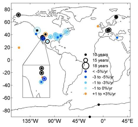 Long-term trends in aerosol properties (figure from Coen Collaud et al., 2013)
Aerosol measurements began at the NOAA Earth System Research Laboratory (ESRL) Global Monitoring Division (GMD) baseline observatories in the mid-1970's with the purpose of detecting a response, or lack of response, of atmospheric aerosols to changing conditions on a global scale. In 1992 ESRL/GMD expanded its aerosol research program to include regional aerosol monitoring stations due to anthropogenic aerosols creating a significant perturbation in the Earth's radiative balance on regional scales. The goals of this regional-scale monitoring program are to characterize means, variability, and trends of climate-forcing properties of different types of aerosols, and the factors that control them. In situ measurements of aerosol optical properties (including light absorption, total scattering, hemispheric backscattering, and total aerosol number concentration) are made at monitoring sites at hourly time resolution. The basic aerosol measurement system consists of a nephelometer (measures aerosol light scattering), absorption photometer (measures light absorption), and a condensation nuclei counter (measures particle number concentration). Data from the aerosol monitoring stations are updated several times a day. Following collection of the raw data at the station, the data are inspected through automatic and manual contamination screenings to eliminate contamination from local pollution sources. Automatic screenings use measured wind speed, direction, and/or total particle number concentration to flag contaminated data. Manual screening is more subjective, relying on the station scientist to evaluate the data in the context of automated contamination flags and their knowledge of the site.
Data applications indicate the importance of continuing to provide long-term aerosol in-situ measurements for use in analysis of trends and climatologies, evaluation of model simulations of aerosol climatologies, and behavior and validation of remote sensing retrievals of aerosol optical properties. GMD's measurements also provide ground-truth for satellite measurements and global models, as well as key aerosol parameters for global-scale models.
Through the Big Earth Data Initiative (BEDI), ESRL/GMD has taken their data collection and converted files into NetCDF-4, a self-describing format.
Dataset Citation
- Cite as: Sheridan, Patrick; Hageman, Derek and NOAA ESRL (2017): Earth System Research Laboratory Long-Term Surface Aerosol Measurements, Version 1. [indicate subset used]. NOAA National Centers for Environmental Information (NCEI). doi:10.7289/V55T3HJF [access date].
Dataset Identifiers
- doi:10.7289/V55T3HJF
- NCEI DSI 3276_01
- gov.noaa.ncdc:C01539
ISO 19115-2 Metadata
gov.noaa.ncdc:C01539
| Search Data |
|
| Download Data |
|
| Distribution Formats |
|
| Ordering Instructions | Contact NCEI for other distribution options and instructions. |
| Distributor |
NOAA National Centers for Environmental Information ncei.info@noaa.gov |
| Dataset Point of Contact | Sheridan, Patrick Physical Scientist DOC/NOAA/ESRL/GMD > Global Monitoring Division, Earth System Research Laboratory, NOAA, U.S. Department of Commerce +1 303-497-6672 esrl.gmd.aero@noaa.goV |
| Dataset Point of Contact | Customer Engagement Branch NOAA National Centers for Environmental Information 1-828-271-4800 ncei.orders@noaa.gov |
| Time Period | 1974-01-01 to Present (time interval: 1-hour) |
| Spatial Bounding Box Coordinates |
West: -180.0
East: 180.0
South: -90.0
North: 90.0
|
| Spatial Coverage Map |
| General Documentation |
|
| Associated Resources |
|
| Publication Dates |
|
| Edition | Version 1 |
| Data Presentation Form | Digital profile - vertical cross-section in digital form |
| Dataset Progress Status | Ongoing - data is continually being updated |
| Data Update Frequency | Annually |
| Purpose | Science organizations, climate researchers, GCM and CTM modelers looking to reproduce in situ observations will be the intended users of this data. |
| Dataset Citation |
|
| Cited Authors |
|
| Originators |
|
| Publishers |
|
| Theme keywords |
Global Change Master Directory (GCMD) Science Keywords
|
| Data Center keywords |
Global Change Master Directory (GCMD) Data Center Keywords
|
| Platform keywords |
Global Change Master Directory (GCMD) Platform Keywords
|
| Instrument keywords |
Global Change Master Directory (GCMD) Instrument Keywords
|
| Place keywords |
Global Change Master Directory (GCMD) Location Keywords
|
| Project keywords |
Global Change Master Directory (GCMD) Project Keywords
|
| Data Resolution keywords |
Global Change Master Directory (GCMD) Horizontal Data Resolution Keywords
|
| Stratum keywords |
Global Change Master Directory (GCMD) Location Keywords
|
| Use Constraints |
|
| Access Constraints |
|
| Fees |
|
| Lineage information for: dataset | |
|---|---|
| Lineage Statement | Raw data are transferred from station computers to a central server, where station mentors perform quality assurance checks on the data. Known corrections to the data are applied, and final averages are calculated. Data are then archived at NCEI. |
| Processor |
|
| Processing Steps |
|
| Processing Environment | The processing environment is a custom software suite on a Linux platform. |
| Source Datasets |
|
| Lineage information for: repository | |
|---|---|
| Processing Steps |
|
Last Modified: 2023-06-23
For questions about the information on this page, please email: ncei.info@noaa.gov
For questions about the information on this page, please email: ncei.info@noaa.gov