International Satellite Cloud Climatology Project (ISCCP) B1 Uniform (B1U) Dataset
ISCCP B1U
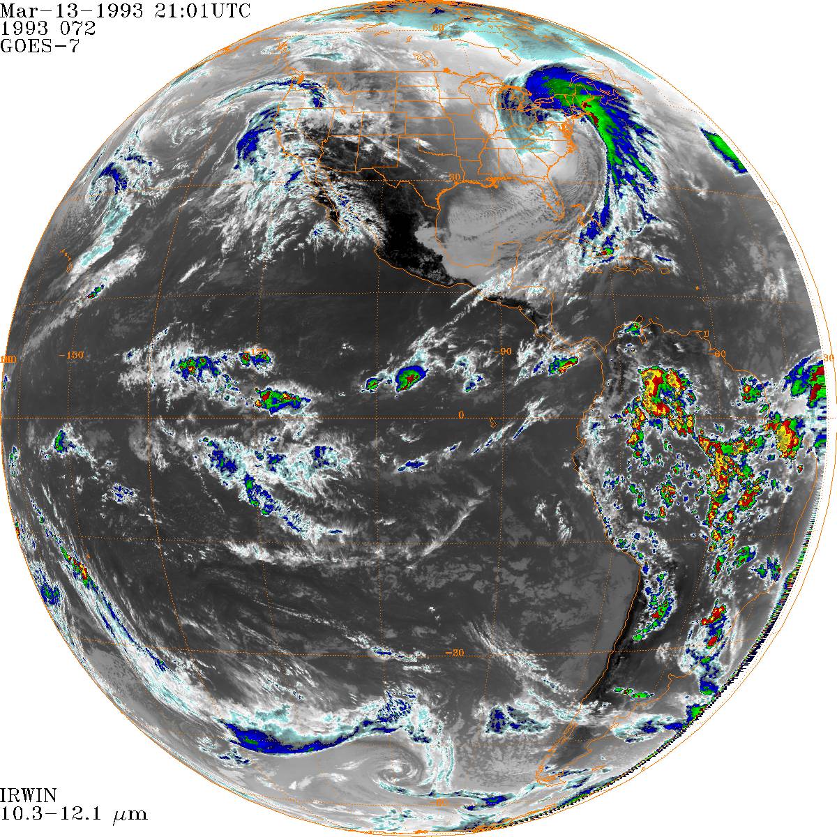 Sample image of ISCCP B1U IRWIN channel during the "Storm of the Century" Blizzard. (1993-03-13-21)
Data are collected from the suite of weather satellites operated by several nations and processed into B1 data by several groups in government agencies, laboratories, and universities. Data is submitted in multiple formats, depending on the satellite and nation submitting the data. In order to alleviate complexity when creating satellite products, NCEI processes the data into the B1 Uniform (B1U) format, which is used in multiple satellite products. Data are included in the ISCCP H-Series collection, but are a intended as a standalone interim product on their own.
Data Variables:
The primary data variable are the satellite radiance scans: the images. The following is a list of the more prevalent imagery:
IRWIN - Infrared window channel image (~11 microns)
VSCHN - Visible Channel image.(~0.6 microns)
IRWVP - Infrared Water Vaport Channel (~6.7 microns)
IRSPL - Split Window IR channel (~12 microns)
There are many other channels. See documentation for list.
The various file headers contain information on
- navigation (i.e., calculating lat/lons for each pixel and vice versa)
- calibration (i.e., calculating physical values for each image count ... e.g., converting counts to temperature)
- timing (to calculate the time of each scan line).
- and more
Measurement resolution is dependent on the source geostationary instrument. The scans were spatially subsampled to reduce the file sizes. This often results in a spatial resolution of 8 - 10 km near satellite nadir (the resolution decreases away from this point).
The images are provided every 3 hours near (but not exactly at) synoptic hours (00, 03, 06, ..., 21 UTC).
The spatial coverage spans the globe (longitudinally) but geostationary satellites can't really observe the poles. The latitudinal extent is about 65 degrees.
The temporal coverage begins in the 1978 for early SMS satellites. Each satellite will have a different temporal span than another. The globe (longitudinally) can be considered covered beginning in 1982 when there were two satellites of the Western Hemisphere, one at the Prime Meridian and another over the Western Pacific (4 total). The true global coverage (5 satellites) began in 1998.
Dataset Citation
- Cite as: Knapp, K. R. (2008): "International Satellite Cloud Climatology Project (ISCCP) B1 Uniform (B1U) Dataset [indicate subset used]." NOAA National Centers for Environmental Information. [indicate access date]
- Please refer to Credit tab for full citation information.
Dataset Identifiers
- NCEI DSI 2010_01
- gov.noaa.ncdc:C01551
ISO 19115-2 Metadata
gov.noaa.ncdc:C01551
| Other Access |
|
| Distribution Formats |
|
| Ordering Instructions | Contact NCEI for other distribution options and instructions. |
| Distributor |
NOAA National Centers for Environmental Information ncei.info@noaa.gov |
| Dataset Point of Contact | Customer Engagement Branch NOAA National Centers for Environmental Information 1-828-271-4800 ncei.orders@noaa.gov |
| Time Period | 1982-01-01 to Present (time interval: 3-hour) |
| Spatial Bounding Box Coordinates |
West: -180.0
East: 180.0
South: -70
North: 70
|
| Spatial Coverage Map |
| General Documentation |
|
| Processing Documents |
|
| Associated Resources |
|
| Publication Dates |
|
| Data Presentation Form | Digital table - digital representation of facts or figures systematically displayed, especially in columns |
| Dataset Progress Status | Ongoing - data is continually being updated |
| Data Update Frequency | Monthly |
| Purpose | The B1U dataset enables researchers to manipulate the raw data that has been received via the ISCCP Program over the past 30 years in a single consistent format. The primary use is climatological - The data provide reduced resolution data that allows global reprocessing at climate time scales (not currently possible with full resolution geostationary data). |
| Use Limitations |
|
| Dataset Citation |
|
| Cited Authors |
|
| Originators |
|
| Publishers |
|
| Theme keywords |
Global Change Master Directory (GCMD) Science Keywords
|
| Data Center keywords |
Global Change Master Directory (GCMD) Data Center Keywords
|
| Platform keywords |
Global Change Master Directory (GCMD) Platform Keywords
|
| Instrument keywords |
Global Change Master Directory (GCMD) Instrument Keywords
|
| Place keywords |
Global Change Master Directory (GCMD) Location Keywords
|
| Project keywords |
Global Change Master Directory (GCMD) Project Keywords
|
| Data Resolution keywords |
Global Change Master Directory (GCMD) Temporal Data Resolution Keywords
|
| Stratum keywords |
Global Change Master Directory (GCMD) Location Keywords
|
| Use Constraints |
|
| Access Constraints |
|
| Fees |
|
| Lineage information for: dataset | |
|---|---|
| Lineage Statement | NCEI produces ISCCP B1U data directly from ISCCP B1 data. The B1 files currently are (and historically have been) sent to NCEI by numerous providers. The original means were 9 track tapes and most recently files are delivered electronically. Each agency provided the file in their own format. This mean that even the same satellite can have different formats if there are different providers for the data (e.g., Canada's AES and NCEI produced GOES 8 data or both CSU abd UWS provided data for early GOES satellites). Thus, the primary purpose of B1U is to reduce the number of decoders needed to read the data from dozens to 1. |
| Processor |
|
| Processing Steps |
|
| Processing Environment | ISCCP B1U data are processed in Linux servers using IDL software. |
| Processing Documents |
|
| Source Datasets |
|
| Lineage information for: repository | |
|---|---|
| Processing Steps |
|
Last Modified: 2023-06-23
For questions about the information on this page, please email: ncei.info@noaa.gov
For questions about the information on this page, please email: ncei.info@noaa.gov