International Satellite Cloud Climatology Project (ISCCP) B1 Uniform (B1U) Dataset
(MI_Metadata)
fileIdentifier: gov.noaa.ncdc:C01551
language: eng; USA
characterSet: (MD_CharacterSetCode) utf8
hierarchyLevel: (MD_ScopeCode) dataset
contact: (CI_ResponsibleParty)
organisationName: NOAA National Centers for Environmental Information
contactInfo: (CI_Contact)
address: (CI_Address)
electronicMailAddress: ncei.info@noaa.gov
onlineResource: (CI_OnlineResource)
linkage: https://www.ncei.noaa.gov/contact
name: NCEI Contact Information
description: Information for contacts at NCEI.
function: (CI_OnLineFunctionCode) information
role: (CI_RoleCode) pointOfContact
dateStamp: 2023-06-23
metadataStandardName: ISO 19115-2 Geographic Information - Metadata - Part 2: Extensions for Imagery and Gridded Data
metadataStandardVersion: ISO 19115-2:2009(E)
return to top
identificationInfo: (MD_DataIdentification)
citation: (CI_Citation)
title: International Satellite Cloud Climatology Project (ISCCP) B1 Uniform (B1U) Dataset
alternateTitle: ISCCP B1U
date: (CI_Date)
date: 2008
dateType: (CI_DateTypeCode) publication
date: (CI_Date)
date: 2006-02-01
dateType: (CI_DateTypeCode) creation
identifier: (MD_Identifier)
code: NCEI DSI 2010_01
identifier: (MD_Identifier)
code: gov.noaa.ncdc:C01551
citedResponsibleParty: (CI_ResponsibleParty)
organisationName: DOC/NOAA/NESDIS/NCEI > National Centers for Environmental Information, NESDIS, NOAA, U.S. Department of Commerce
role: (CI_RoleCode) publisher
citedResponsibleParty: (CI_ResponsibleParty)
organisationName: DOC/NOAA/NESDIS/NCEI > National Centers for Environmental Information, NESDIS, NOAA, U.S. Department of Commerce
role: (CI_RoleCode) originator
citedResponsibleParty: (CI_ResponsibleParty)
organisationName: DOC/NOAA/NESDIS/NCEI > National Centers for Environmental Information, NESDIS, NOAA, U.S. Department of Commerce
role: (CI_RoleCode) author
presentationForm: (CI_PresentationFormCode) tableDigital
abstract: Data are collected from the suite of weather satellites operated by several nations and processed into B1 data by several groups in government agencies, laboratories, and universities. Data is submitted in multiple formats, depending on the satellite and nation submitting the data. In order to alleviate complexity when creating satellite products, NCEI processes the data into the B1 Uniform (B1U) format, which is used in multiple satellite products. Data are included in the ISCCP H-Series collection, but are a intended as a standalone interim product on their own. Data Variables: The primary data variable are the satellite radiance scans: the images. The following is a list of the more prevalent imagery: IRWIN - Infrared window channel image (~11 microns) VSCHN - Visible Channel image.(~0.6 microns) IRWVP - Infrared Water Vaport Channel (~6.7 microns) IRSPL - Split Window IR channel (~12 microns) There are many other channels. See documentation for list. The various file headers contain information on - navigation (i.e., calculating lat/lons for each pixel and vice versa) - calibration (i.e., calculating physical values for each image count ... e.g., converting counts to temperature) - timing (to calculate the time of each scan line). - and more Measurement resolution is dependent on the source geostationary instrument. The scans were spatially subsampled to reduce the file sizes. This often results in a spatial resolution of 8 - 10 km near satellite nadir (the resolution decreases away from this point). The images are provided every 3 hours near (but not exactly at) synoptic hours (00, 03, 06, ..., 21 UTC). The spatial coverage spans the globe (longitudinally) but geostationary satellites can't really observe the poles. The latitudinal extent is about 65 degrees. The temporal coverage begins in the 1978 for early SMS satellites. Each satellite will have a different temporal span than another. The globe (longitudinally) can be considered covered beginning in 1982 when there were two satellites of the Western Hemisphere, one at the Prime Meridian and another over the Western Pacific (4 total). The true global coverage (5 satellites) began in 1998.
purpose: The B1U dataset enables researchers to manipulate the raw data that has been received via the ISCCP Program over the past 30 years in a single consistent format. The primary use is climatological - The data provide reduced resolution data that allows global reprocessing at climate time scales (not currently possible with full resolution geostationary data).
status: (MD_ProgressCode) onGoing
pointOfContact: (CI_ResponsibleParty)
organisationName: NOAA National Centers for Environmental Information
positionName: Customer Engagement Branch
contactInfo: (CI_Contact)
phone: (CI_Telephone)
voice: 1-828-271-4800
facsimile: 1-828-271-4876
address: (CI_Address)
deliveryPoint: 151 Patton Avenue
deliveryPoint: Veach-Baley Federal Building, Room 468
city: Asheville
administrativeArea: NC
postalCode: 28801-5001
country: USA
electronicMailAddress: ncei.orders@noaa.gov
onlineResource: (CI_OnlineResource)
linkage: https://www.ncei.noaa.gov
protocol: HTTPS
applicationProfile: Web Browser
name: NOAA National Centers for Environmental Information (NCEI)
description: NCEI home page with information, data access and contact information.
function: (CI_OnLineFunctionCode) information
hoursOfService: 8:00 - 6:00 Eastern
role: (CI_RoleCode) pointOfContact
resourceMaintenance: (MD_MaintenanceInformation)
maintenanceAndUpdateFrequency: (MD_MaintenanceFrequencyCode) monthly
graphicOverview: (MD_BrowseGraphic)
fileName: https://www.ncei.noaa.gov/pub/data/metadata/images/C01551_ISCCP-B1U.jpg
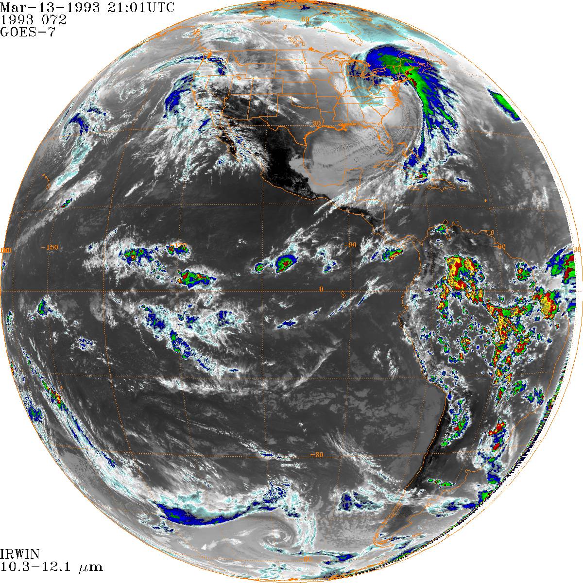
fileDescription: Sample image of ISCCP B1U IRWIN channel during the "Storm of the Century" Blizzard. (1993-03-13-21)
fileType: JPEG
descriptiveKeywords: (MD_Keywords)
keyword: Earth Science > Atmosphere > Clouds
keyword: Earth Science > Atmosphere > Clouds > Cloud Properties
keyword: Earth Science > Atmosphere > Atmospheric Radiation
type: (MD_KeywordTypeCode) theme
thesaurusName: (CI_Citation)
title: Global Change Master Directory (GCMD) Science Keywords
date: (CI_Date)
date: 2018
dateType: (CI_DateTypeCode) revision
edition: Version 8.6
citedResponsibleParty: (CI_ResponsibleParty)
organisationName: Global Change Data Center, Science and Exploration Directorate, Goddard Space Flight Center (GSFC) National Aeronautics and Space Administration (NASA)
contactInfo: (CI_Contact)
onlineResource: (CI_OnlineResource)
linkage: https://earthdata.nasa.gov/about/gcmd/global-change-master-directory-gcmd-keywords
protocol: HTTPS
applicationProfile: Web Browser
name: Global Change Master Directory (GCMD) Keywords
description: The information provided on this page seeks to define how the GCMD Keywords are structured, used and accessed. It also provides information on how users can participate in the further development of the keywords.
function: (CI_OnLineFunctionCode) information
role: (CI_RoleCode) publisher
descriptiveKeywords: (MD_Keywords)
keyword: Atmospheric - Upper-air - Cloud Properties
keyword: Atmospheric - Upper-air - Earth Radiation Budget
type: (MD_KeywordTypeCode) theme
thesaurusName: (CI_Citation)
title: Global Climate Observing System (GCOS) Essential Climate Variables (ECVs)
date: (CI_Date)
date: 2017
dateType: (CI_DateTypeCode) publication
edition: Release 2017
citedResponsibleParty: (CI_ResponsibleParty)
organisationName: World Meteorological Organization, United Nations
contactInfo: (CI_Contact)
onlineResource: (CI_OnlineResource)
linkage: https://public.wmo.int/en/programmes/global-climate-observing-system/essential-climate-variables
protocol: HTTP
applicationProfile: Information
name: GCOS Essential Climate Variables
description: Overview of the GCOS Essential Climate Variables.
function: (CI_OnLineFunctionCode) information
role: (CI_RoleCode) custodian
descriptiveKeywords: (MD_Keywords)
keyword: Geographic Region > Global
type: (MD_KeywordTypeCode) place
thesaurusName: (CI_Citation)
title: Global Change Master Directory (GCMD) Location Keywords
date: (CI_Date)
date: 2018
dateType: (CI_DateTypeCode) revision
edition: Version 8.6
citedResponsibleParty: (CI_ResponsibleParty)
organisationName: Global Change Data Center, Science and Exploration Directorate, Goddard Space Flight Center (GSFC) National Aeronautics and Space Administration (NASA)
contactInfo: (CI_Contact)
onlineResource: (CI_OnlineResource)
linkage: https://earthdata.nasa.gov/about/gcmd/global-change-master-directory-gcmd-keywords
protocol: HTTPS
applicationProfile: Web Browser
name: Global Change Master Directory (GCMD) Keywords
description: The information provided on this page seeks to define how the GCMD Keywords are structured, used and accessed. It also provides information on how users can participate in the further development of the keywords.
function: (CI_OnLineFunctionCode) information
role: (CI_RoleCode) publisher
descriptiveKeywords: (MD_Keywords)
keyword: Vertical Location > Land Surface
keyword: Vertical Location > Boundary Layer
keyword: Vertical Location > Troposphere
type: (MD_KeywordTypeCode) stratum
thesaurusName: (CI_Citation)
title: Global Change Master Directory (GCMD) Location Keywords
date: (CI_Date)
date: 2018
dateType: (CI_DateTypeCode) revision
edition: Version 8.6
citedResponsibleParty: (CI_ResponsibleParty)
organisationName: Global Change Data Center, Science and Exploration Directorate, Goddard Space Flight Center (GSFC) National Aeronautics and Space Administration (NASA)
contactInfo: (CI_Contact)
onlineResource: (CI_OnlineResource)
linkage: https://earthdata.nasa.gov/about/gcmd/global-change-master-directory-gcmd-keywords
protocol: HTTPS
applicationProfile: Web Browser
name: Global Change Master Directory (GCMD) Keywords
description: The information provided on this page seeks to define how the GCMD Keywords are structured, used and accessed. It also provides information on how users can participate in the further development of the keywords.
function: (CI_OnLineFunctionCode) information
role: (CI_RoleCode) publisher
descriptiveKeywords: (MD_Keywords)
keyword: ISCCP > International Satellite Cloud Climatology Project
type: (MD_KeywordTypeCode) project
thesaurusName: (CI_Citation)
title: Global Change Master Directory (GCMD) Project Keywords
date: (CI_Date)
date: 2018
dateType: (CI_DateTypeCode) revision
edition: Version 8.6
citedResponsibleParty: (CI_ResponsibleParty)
organisationName: Global Change Data Center, Science and Exploration Directorate, Goddard Space Flight Center (GSFC) National Aeronautics and Space Administration (NASA)
contactInfo: (CI_Contact)
onlineResource: (CI_OnlineResource)
linkage: https://earthdata.nasa.gov/about/gcmd/global-change-master-directory-gcmd-keywords
protocol: HTTPS
applicationProfile: Web Browser
name: Global Change Master Directory (GCMD) Keywords
description: The information provided on this page seeks to define how the GCMD Keywords are structured, used and accessed. It also provides information on how users can participate in the further development of the keywords.
function: (CI_OnLineFunctionCode) information
role: (CI_RoleCode) publisher
descriptiveKeywords: (MD_Keywords)
keyword: Earth Remote Sensing Instruments
keyword: Passive Remote Sensing
keyword: Spectrometers/Radiometers
keyword: Imaging Spectrometers/Radiometers
keyword: AVHRR > Advanced Very High Resolution Radiometer
keyword: AVHRR-2 > Advanced Very High Resolution Radiometer-2
keyword: AVHRR-3 > Advanced Very High Resolution Radiometer-3
type: (MD_KeywordTypeCode) instrument
thesaurusName: (CI_Citation)
title: Global Change Master Directory (GCMD) Instrument Keywords
date: (CI_Date)
date: 2018
dateType: (CI_DateTypeCode) revision
edition: Version 8.6
citedResponsibleParty: (CI_ResponsibleParty)
organisationName: Global Change Data Center, Science and Exploration Directorate, Goddard Space Flight Center (GSFC) National Aeronautics and Space Administration (NASA)
contactInfo: (CI_Contact)
onlineResource: (CI_OnlineResource)
linkage: https://earthdata.nasa.gov/about/gcmd/global-change-master-directory-gcmd-keywords
protocol: HTTPS
applicationProfile: Web Browser
name: Global Change Master Directory (GCMD) Keywords
description: The information provided on this page seeks to define how the GCMD Keywords are structured, used and accessed. It also provides information on how users can participate in the further development of the keywords.
function: (CI_OnLineFunctionCode) information
role: (CI_RoleCode) publisher
descriptiveKeywords: (MD_Keywords)
keyword: GOES-9 > Geostationary Operational Environmental Satellite 9
keyword: METEOSAT-2
keyword: METEOSAT-3
keyword: METEOSAT-4 > Meteosat Operational Programme 1 (MOP-1)
keyword: METEOSAT-5 > Meteosat Operational Programme 2 (MOP-2)
keyword: METEOSAT-6 > Meteosat Operational Programme 3 (MOP-3)
keyword: METEOSAT-7
keyword: METEOSAT-8
keyword: METEOSAT-9
keyword: METEOSAT-10
keyword: GOES-6 > Geostationary Operational Environmental Satellite 6
keyword: GOES-7 > Geostationary Operational Environmental Satellite 7
keyword: GOES-9 > Geostationary Operational Environmental Satellite 9
keyword: GOES-10 > Geostationary Operational Environmental Satellite 10
keyword: GOES-11 > Geostationary Operational Environmental Satellite 11
keyword: GOES-4 > Geostationary Operational Environmental Satellite 4
keyword: GOES-5 > Geostationary Operational Environmental Satellite 5
keyword: GOES-8 > Geostationary Operational Environmental Satellite 8
keyword: GOES-12 > Geostationary Operational Environmental Satellite 12
keyword: GOES-13 > Geostationary Operational Environmental Satellite 13
keyword: GOES-15 > Geostationary Operational Environmental Satellite 15
type: (MD_KeywordTypeCode) platform
thesaurusName: (CI_Citation)
title: Global Change Master Directory (GCMD) Platform Keywords
date: (CI_Date)
date: 2018
dateType: (CI_DateTypeCode) revision
edition: Version 8.6
citedResponsibleParty: (CI_ResponsibleParty)
organisationName: Global Change Data Center, Science and Exploration Directorate, Goddard Space Flight Center (GSFC) National Aeronautics and Space Administration (NASA)
contactInfo: (CI_Contact)
onlineResource: (CI_OnlineResource)
linkage: https://earthdata.nasa.gov/about/gcmd/global-change-master-directory-gcmd-keywords
protocol: HTTPS
applicationProfile: Web Browser
name: Global Change Master Directory (GCMD) Keywords
description: The information provided on this page seeks to define how the GCMD Keywords are structured, used and accessed. It also provides information on how users can participate in the further development of the keywords.
function: (CI_OnLineFunctionCode) information
role: (CI_RoleCode) publisher
descriptiveKeywords: (MD_Keywords)
keyword: Hourly - < Daily
type: (MD_KeywordTypeCode) dataResolution
thesaurusName: (CI_Citation)
title: Global Change Master Directory (GCMD) Temporal Data Resolution Keywords
date: (CI_Date)
date: 2018
dateType: (CI_DateTypeCode) revision
edition: Version 8.6
citedResponsibleParty: (CI_ResponsibleParty)
organisationName: Global Change Data Center, Science and Exploration Directorate, Goddard Space Flight Center (GSFC) National Aeronautics and Space Administration (NASA)
contactInfo: (CI_Contact)
onlineResource: (CI_OnlineResource)
linkage: https://earthdata.nasa.gov/about/gcmd/global-change-master-directory-gcmd-keywords
protocol: HTTPS
applicationProfile: Web Browser
name: Global Change Master Directory (GCMD) Keywords
description: The information provided on this page seeks to define how the GCMD Keywords are structured, used and accessed. It also provides information on how users can participate in the further development of the keywords.
function: (CI_OnLineFunctionCode) information
role: (CI_RoleCode) publisher
descriptiveKeywords: (MD_Keywords)
keyword: 10 km - < 50 km or approximately .09 degree - < .5 degree
type: (MD_KeywordTypeCode) dataResolution
thesaurusName: (CI_Citation)
title: Global Change Master Directory (GCMD) Horizontal Data Resolution Keywords
date: (CI_Date)
date: 2018
dateType: (CI_DateTypeCode) revision
edition: Version 8.6
citedResponsibleParty: (CI_ResponsibleParty)
organisationName: Global Change Data Center, Science and Exploration Directorate, Goddard Space Flight Center (GSFC) National Aeronautics and Space Administration (NASA)
contactInfo: (CI_Contact)
onlineResource: (CI_OnlineResource)
linkage: https://earthdata.nasa.gov/about/gcmd/global-change-master-directory-gcmd-keywords
protocol: HTTPS
applicationProfile: Web Browser
name: Global Change Master Directory (GCMD) Keywords
description: The information provided on this page seeks to define how the GCMD Keywords are structured, used and accessed. It also provides information on how users can participate in the further development of the keywords.
function: (CI_OnLineFunctionCode) information
role: (CI_RoleCode) publisher
descriptiveKeywords: (MD_Keywords)
keyword: > 1 km
type: (MD_KeywordTypeCode) dataResolution
thesaurusName: (CI_Citation)
title: Global Change Master Directory (GCMD) Vertical Data Resolution Keywords
date: (CI_Date)
date: 2018
dateType: (CI_DateTypeCode) revision
edition: Version 8.6
citedResponsibleParty: (CI_ResponsibleParty)
organisationName: Global Change Data Center, Science and Exploration Directorate, Goddard Space Flight Center (GSFC) National Aeronautics and Space Administration (NASA)
contactInfo: (CI_Contact)
onlineResource: (CI_OnlineResource)
linkage: https://earthdata.nasa.gov/about/gcmd/global-change-master-directory-gcmd-keywords
protocol: HTTPS
applicationProfile: Web Browser
name: Global Change Master Directory (GCMD) Keywords
description: The information provided on this page seeks to define how the GCMD Keywords are structured, used and accessed. It also provides information on how users can participate in the further development of the keywords.
function: (CI_OnLineFunctionCode) information
role: (CI_RoleCode) publisher
descriptiveKeywords: (MD_Keywords)
keyword: DOC/NOAA/NESDIS/NCEI > National Centers for Environmental Information, NESDIS, NOAA, U.S. Department of Commerce
type: (MD_KeywordTypeCode) dataCentre
thesaurusName: (CI_Citation)
title: Global Change Master Directory (GCMD) Data Center Keywords
date: (CI_Date)
date: 2018
dateType: (CI_DateTypeCode) revision
edition: Version 8.6
citedResponsibleParty: (CI_ResponsibleParty)
organisationName: Global Change Data Center, Science and Exploration Directorate, Goddard Space Flight Center (GSFC) National Aeronautics and Space Administration (NASA)
contactInfo: (CI_Contact)
onlineResource: (CI_OnlineResource)
linkage: https://earthdata.nasa.gov/about/gcmd/global-change-master-directory-gcmd-keywords
protocol: HTTPS
applicationProfile: Web Browser
name: Global Change Master Directory (GCMD) Keywords
description: The information provided on this page seeks to define how the GCMD Keywords are structured, used and accessed. It also provides information on how users can participate in the further development of the keywords.
function: (CI_OnLineFunctionCode) information
role: (CI_RoleCode) publisher
resourceConstraints: (MD_Constraints)
useLimitation: Spatial sampling limits resolution to roughly 8 km.
resourceConstraints: (MD_Constraints)
useLimitation: Temporal sampling can't resolve phenomena at times more than every 3 hours.
resourceConstraints: (MD_Constraints)
useLimitation: The early data (prior to 2012) most of the data were dynamically redused to 8-bit values (0-255). More recent data is generally at the full satellite resolution (e.g., up to 10-12 bits).
resourceConstraints: (MD_Constraints)
useLimitation: See associated documentation for a full description of use limitations.
resourceConstraints: (MD_LegalConstraints)
useConstraints: (MD_RestrictionCode) otherRestrictions
otherConstraints: Cite as: Knapp, K. R. (2008): "International Satellite Cloud Climatology Project (ISCCP) B1 Uniform (B1U) Dataset [indicate subset used]." NOAA National Centers for Environmental Information. [indicate access date]
resourceConstraints: (MD_LegalConstraints)
useConstraints: (MD_RestrictionCode) otherRestrictions
otherConstraints: Users should also cite Knapp (2008) when using the ISCCP-B1 data or other ISCCP-B1 imagery or GIBBS imagery in a publication or website. Knapp, K. R., 2008: Scientific data stewardship of International Satellite Cloud Climatology Project B1 global geostationary observations. Journal of Applied Remote Sensing, 2, 023548, doi:10.1117/1.3043461
resourceConstraints: (MD_LegalConstraints)
accessConstraints: (MD_RestrictionCode) otherRestrictions
otherConstraints: Distribution liability: NOAA and NCEI make no warranty, expressed or implied, regarding these data, nor does the fact of distribution constitute such a warranty. NOAA and NCEI cannot assume liability for any damages caused by any errors or omissions in these data. If appropriate, NCEI can only certify that the data it distributes are an authentic copy of the records that were accepted for inclusion in the NCEI archives.
resourceConstraints: (MD_LegalConstraints)
useConstraints: (MD_RestrictionCode) otherRestrictions
otherConstraints: Use liability: NOAA and NCEI cannot provide any warranty as to the accuracy, reliability, or completeness of furnished data. Users assume responsibility to determine the usability of these data. The user is responsible for the results of any application of this data for other than its intended purpose.
aggregationInfo: (MD_AggregateInformation)
aggregateDataSetName: (CI_Citation)
title: International Satellite Cloud Climate Project (ISCCP) Climate Data Record (CDR) - H Series Data
date: (missing)
citedResponsibleParty: (CI_ResponsibleParty)
organisationName: DOC/NOAA/NESDIS/NCEI > National Centers for Environmental Information, NESDIS, NOAA, U.S. Department of Commerce
role: (CI_RoleCode) publisher
citedResponsibleParty: (CI_ResponsibleParty)
organisationName: (missing)
contactInfo: (CI_Contact)
onlineResource: (CI_OnlineResource)
linkage: https://doi.org/10.7289/V5QZ281S
protocol: HTTPS
applicationProfile: Web Browser
name: International Satellite Cloud Climate Project (ISCCP) Climate Data Record (CDR) - H Series Data
description: The ISCCP H-Series CDR was created using the B1U dataset. The B1U collection was submitted as part of the H-Series data collection.
function: (CI_OnLineFunctionCode) information
role: (missing)
associationType: (DS_AssociationTypeCode) crossReference
initiativeType: (DS_InitiativeTypeCode) collection
aggregationInfo: (MD_AggregateInformation)
aggregateDataSetName: (CI_Citation)
title: NASA GISS ISCCP Web Page
date: (missing)
citedResponsibleParty: (CI_ResponsibleParty)
organisationName: NASA
role: (CI_RoleCode) publisher
citedResponsibleParty: (CI_ResponsibleParty)
organisationName: (missing)
contactInfo: (CI_Contact)
onlineResource: (CI_OnlineResource)
linkage: http://isccp.giss.nasa.gov/
applicationProfile: Web Browser
name: NASA GISS ISCCP Web Page
description: More information about the ISCCP Program, hosted by NASA-GISS
function: (CI_OnLineFunctionCode) information
role: (missing)
associationType: (DS_AssociationTypeCode) crossReference
initiativeType: (DS_InitiativeTypeCode) collection
aggregationInfo: (MD_AggregateInformation)
aggregateDataSetName: (CI_Citation)
title: Scientific data stewardship of International Satellite Cloud Climatology Project B1 global geostationary observations (Science Paper)
date: (missing)
identifier: (MD_Identifier)
code: doi:10.1117/1.3043461
citedResponsibleParty: (CI_ResponsibleParty)
organisationName: Journal of Applied Remote Sensing
role: (CI_RoleCode) publisher
citedResponsibleParty: (CI_ResponsibleParty)
organisationName: (missing)
contactInfo: (CI_Contact)
onlineResource: (CI_OnlineResource)
linkage: https://doi.org/10.1117/1.3043461
protocol: HTTPS
applicationProfile: Web Browser
name: Science Paper
description: Knapp, K. R., 2008: Scientific data stewardship of International Satellite Cloud Climatology Project B1 global geostationary observations. Journal of Applied Remote Sensing, 2, 023548, doi:10.1117/1.3043461
function: (CI_OnLineFunctionCode) information
role: (missing)
associationType: (DS_AssociationTypeCode) largerWorkCitation
initiativeType: (DS_InitiativeTypeCode) sciencePaper
spatialRepresentationType: (MD_SpatialRepresentationTypeCode) grid
spatialResolution: (MD_Resolution)
distance:
Distance: 8000
language: eng; USA
topicCategory: (MD_TopicCategoryCode) climatologyMeteorologyAtmosphere
environmentDescription: ISCCP B1U data are processed in Linux servers using IDL software.
extent: (EX_Extent)
geographicElement: (EX_GeographicBoundingBox)
extentTypeCode: 1
westBoundLongitude: -180.0
eastBoundLongitude: 180.0
southBoundLatitude: -70
northBoundLatitude: 70
temporalElement: (EX_TemporalExtent)
extent:
TimePeriod:
description: ground condition
beginPosition: 1982-01-01
endPosition:
timeInterval: 3
return to top
distributionInfo: (MD_Distribution)
distributor: (MD_Distributor)
distributorContact: (CI_ResponsibleParty)
organisationName: NOAA National Centers for Environmental Information
contactInfo: (CI_Contact)
address: (CI_Address)
electronicMailAddress: ncei.info@noaa.gov
onlineResource: (CI_OnlineResource)
linkage: https://www.ncei.noaa.gov/contact
name: NCEI Contact Information
description: Information for contacts at NCEI.
function: (CI_OnLineFunctionCode) information
role: (CI_RoleCode) distributor
distributionOrderProcess: (MD_StandardOrderProcess)
fees: In most cases, electronic downloads of the data are free. However, fees may apply for custom orders, data certifications, copies of analog materials, and data distribution on physical media.
orderingInstructions: Contact NCEI for other distribution options and instructions.
distributorFormat: (MD_Format)
name: Binary
version: (missing)
distributorFormat: (MD_Format)
name: Binary
version: (missing)
distributorTransferOptions: (MD_DigitalTransferOptions)
onLine: (CI_OnlineResource)
linkage: https://www.ncei.noaa.gov/metadata/geoportal/rest/metadata/item/gov.noaa.ncdc:C01551/html
protocol: HTTPS
applicationProfile: Landing Page
name: NCEI Dataset Landing Page
description: Landing page for the dataset.
function: (CI_OnLineFunctionCode) information
distributorTransferOptions: (MD_DigitalTransferOptions)
transferSize: (missing)
onLine: (CI_OnlineResource)
linkage: https://www.ncei.noaa.gov/contact
protocol: HTTPS
applicationProfile: Web Browser
name: NCEI Customer Support
description: This dataset is not currently available for public download from NCEI. Please contact NCEI to request access to these data.
function: (CI_OnLineFunctionCode) offlineAccess
distributorTransferOptions: (MD_DigitalTransferOptions)
transferSize: (missing)
onLine: (CI_OnlineResource)
linkage: https://www.ncdc.noaa.gov/isccp
protocol: HTTPS
applicationProfile: Information
name: ISSCP Web Site hosted by NCEI
description: More information about the ISCCP Program and the data archived at NCEI.
function: (CI_OnLineFunctionCode) information
distributorTransferOptions: (MD_DigitalTransferOptions)
transferSize: (missing)
onLine: (CI_OnlineResource)
linkage: https://www.ncdc.noaa.gov/gridsat/isccp-b1-info.php
protocol: HTTPS
applicationProfile: Web Browser
name: ISCCP B1 Website
description: Describes ISCCP B1 data and B1U
function: (CI_OnLineFunctionCode) information
return to top
dataQualityInfo: (DQ_DataQuality)
scope: (DQ_Scope)
level: (MD_ScopeCode) dataset
extent: #boundingExtent
lineage: (LI_Lineage)
statement: NCEI produces ISCCP B1U data directly from ISCCP B1 data. The B1 files currently are (and historically have been) sent to NCEI by numerous providers. The original means were 9 track tapes and most recently files are delivered electronically. Each agency provided the file in their own format. This mean that even the same satellite can have different formats if there are different providers for the data (e.g., Canada's AES and NCEI produced GOES 8 data or both CSU abd UWS provided data for early GOES satellites). Thus, the primary purpose of B1U is to reduce the number of decoders needed to read the data from dozens to 1.
processStep: (LE_ProcessStep)
description: Reformat data and write to file in the B1U binary format.
rationale: Each agency provided the file in their own format. This mean that even the same satellite can have different formats if there are different providers for the data (e.g., Canada's AES and NCEI produced GOES 8 data or both CSU abd UWS provided data for early GOES satellites). Thus, the primary purpose of B1U is to reduce the number of decoders needed to read the data from dozens to 1.
dateTime: (missing)
processor: (CI_ResponsibleParty)
organisationName: DOC/NOAA/NESDIS/NCEI > National Centers for Environmental Information, NESDIS, NOAA, U.S. Department of Commerce
role: (CI_RoleCode) processor
source: sd001
processingInformation: (LE_Processing)
identifier: (missing)
algorithm: (LE_Algorithm)
citation: (CI_Citation)
title: B1U Data Format
date: (CI_Date)
date: 2006-01-26
dateType: (CI_DateTypeCode) publication
citedResponsibleParty: (CI_ResponsibleParty)
organisationName: DOC/NOAA/NESDIS/NCEI > National Centers for Environmental Information, NESDIS, NOAA, U.S. Department of Commerce
role: (CI_RoleCode) author
citedResponsibleParty: (CI_ResponsibleParty)
organisationName: (missing)
contactInfo: (CI_Contact)
onlineResource: (CI_OnlineResource)
linkage: ftp://eclipse.ncdc.noaa.gov/san1/isccp/b1/B1_Unified_Format_Description.pdf
applicationProfile: Web Browser
name: B1U Data Format
description: ISCCP B1U Data Format
function: (CI_OnLineFunctionCode) information
role: (missing)
description: See Algorithm Citation
source: (LE_Source)
description: B1 data
sourceCitation: (CI_Citation)
title: ISCCP B1 Data
date: (missing)
citedResponsibleParty: (CI_ResponsibleParty)
organisationName: DOC/NOAA/NESDIS/NCEI > National Centers for Environmental Information, NESDIS, NOAA, U.S. Department of Commerce
role: (CI_RoleCode) custodian
citedResponsibleParty: (CI_ResponsibleParty)
organisationName: (missing)
contactInfo: (CI_Contact)
onlineResource: (CI_OnlineResource)
linkage: https://www.ncei.noaa.gov/metadata/geoportal/rest/metadata/item/gov.noaa.ncdc:C00576/html
protocol: HTTPS
applicationProfile: Web Browser
name: ISCCP B1 Data
description: Source dataset landing page with general information and access links for that dataset.
function: (CI_OnLineFunctionCode) information
role: (missing)
sourceExtent: (EX_Extent)
geographicElement: (EX_GeographicBoundingBox)
extentTypeCode: 1
westBoundLongitude: 180
eastBoundLongitude: 180
southBoundLatitude: 70
northBoundLatitude: 70
temporalElement: (EX_TemporalExtent)
extent:
TimePeriod:
beginPosition: 1978-01-01
endPosition:
sourceStep: ps001
return to top
dataQualityInfo: (DQ_DataQuality)
scope: (DQ_Scope)
level: (MD_ScopeCode) repository
levelDescription: (MD_ScopeDescription)
other: NOAA National Centers for Environmental Information
lineage: (LI_Lineage)
processStep: (LE_ProcessStep)
description: NOAA created the National Centers for Environmental Information (NCEI) by merging NOAA's National Climatic Data Center (NCDC), National Geophysical Data Center (NGDC), and National Oceanographic Data Center (NODC), including the National Coastal Data Development Center (NCDDC), per the Consolidated and Further Continuing Appropriations Act, 2015, Public Law 113-235. NCEI launched publicly on April 22, 2015.
dateTime:
DateTime: 2015-04-22T00:00:00
return to top
metadataMaintenance: (MD_MaintenanceInformation)
maintenanceAndUpdateFrequency: (MD_MaintenanceFrequencyCode) asNeeded
maintenanceNote: Bulk metadata change applied on 2023-06-23. See version control repository history for metadata change details.