Earth System Research Laboratory Ozone Water Vapor Group Ozonesonde Measurements
ESRL GMD OZWV Ozonesonde
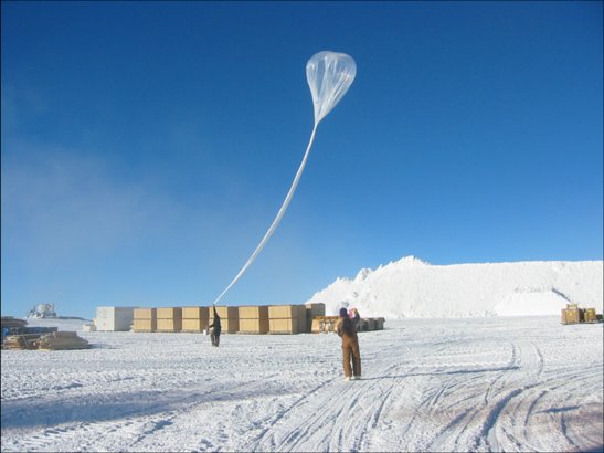 Ozonesonde Launch at the South Pole
The Ozone and Water Vapor Group is part of NOAA's Earth System Research Laboratory (ESRL) in Boulder, CO. The Ozone Water Vapor Group conducts research on the nature and causes of the depletion of the stratospheric ozone layer and the role of stratospheric and tropospheric ozone and water vapor in forcing climate change and in modifying the chemical cleaning capacity of the atmosphere. This is accomplished through long-term observations and intensive field programs that measure ozone and water vapor levels in the upper troposphere and stratosphere. The Reference Network used by the Ozone and Water Vapor Group is part of NOAA's Earth System Research Laboratory in Boulder, CO. The measurement programs include Total Column Ozone Measurements (Dobson Ozone), Surface Ozone Measurements, Ozonesonde Measurements using balloons, and Water Vapor measurements using balloons.
An ozonesonde is a lightweight, balloon-borne instrument that is mated to a conventional meteorological radiosonde. As the balloon ascends through the atmosphere it sends information on ozone and standard meteorological quantities (air temperature, pressure, and relative humidity) back to a ground receiving station. The balloon is able to ascend to altitudes of about 115,000 feet (35 km) in about two hours before it will burst. Ozonesonde are launched approximately weekly from 9 locations including American Samoa, Antarctica, Greenland, Fiji, and the United States (Alabama, California, Colorado, Hawaii, and Rhode Island). The data have been collected since 1967.
An ozonesonde is a lightweight, balloon-borne instrument that is mated to a conventional meteorological radiosonde. As the balloon ascends through the atmosphere it sends information on ozone and standard meteorological quantities (air temperature, pressure, and relative humidity) back to a ground receiving station. The balloon is able to ascend to altitudes of about 115,000 feet (35 km) in about two hours before it will burst. Ozonesonde are launched approximately weekly from 9 locations including American Samoa, Antarctica, Greenland, Fiji, and the United States (Alabama, California, Colorado, Hawaii, and Rhode Island). The data have been collected since 1967.
Dataset Citation
- Cite as: Johnson, Bryan J.; Cullis, Patrick D.; and NOAA ESRL (2018): Earth System Research Laboratory Ozone Water Vapor Group Ozonesonde Measurements, Version 1. [indicate subset used]. NOAA National Centers for Environmental Information. doi:10.7289/V5CC0XZ1 [access date].
Dataset Identifiers
- doi:10.7289/V5CC0XZ1
- NCEI DSI 3267_01
- gov.noaa.ncdc:C01563
ISO 19115-2 Metadata
gov.noaa.ncdc:C01563
| Download Data |
|
| Distribution Formats |
|
| Ordering Instructions | Contact NCEI for other distribution options and instructions. |
| Distributor |
NOAA National Centers for Environmental Information ncei.info@noaa.gov |
| Dataset Point of Contact | Jordan, Allen Software/Electrical Engineer DOC/NOAA/ESRL/GMD > Global Monitoring Division, Earth System Research Laboratory, NOAA, U.S. Department of Commerce (303) 497-4781 allen.jordan@noaa.gov |
| Dataset Point of Contact | McClure-Begley, Audra Associate Scientist DOC/NOAA/ESRL/GMD > Global Monitoring Division, Earth System Research Laboratory, NOAA, U.S. Department of Commerce (303) 497-6823 audra.mcclure@noaa.gov |
| Time Period | 1967-01-17 to Present |
| Spatial Bounding Box Coordinates |
West: -180.0
East: 180.0
South: -90.0
North: 90.0
|
| Spatial Coverage Map |
| General Documentation |
|
| Associated Resources |
|
| Publication Dates |
|
| Edition | 1 |
| Data Presentation Form | Digital table - digital representation of facts or figures systematically displayed, especially in columns |
| Dataset Progress Status | Ongoing - data is continually being updated |
| Data Update Frequency | Weekly |
| Purpose | The Ozone and Water Vapor Group conducts research on the nature and causes of the depletion of the stratospheric ozone layer and the role of stratospheric and tropospheric ozone and water vapor in forcing climate change and in modifying the chemical cleansing capacity of the atmosphere. This data will be used by researchers with a similar mission. |
| Use Limitations |
|
| Dataset Citation |
|
| Cited Authors |
|
| Principal Investigators |
|
| Collaborators |
|
| Publishers |
|
| Theme keywords |
Global Change Master Directory (GCMD) Science Keywords
|
| Data Center keywords |
Global Change Master Directory (GCMD) Data Center Keywords
|
| Platform keywords |
Global Change Master Directory (GCMD) Platform Keywords
|
| Instrument keywords |
Global Change Master Directory (GCMD) Instrument Keywords
|
| Place keywords |
Global Change Master Directory (GCMD) Location Keywords
|
| Project keywords |
Global Change Master Directory (GCMD) Project Keywords
|
| Data Resolution keywords |
Global Change Master Directory (GCMD) Vertical Data Resolution Keywords
|
| Stratum keywords |
Global Change Master Directory (GCMD) Location Keywords
|
| Use Constraints |
|
| Access Constraints |
|
| Fees |
|
| Lineage information for: dataset | |
|---|---|
| Lineage Statement | Over 50 years of records of balloon ozonesonde launches initiating at Boulder CO. The dataset originated here at NOAA ESRL, starting with strip chart recordings of sondes in the late 60s. |
| Processing Environment | Windows, using in-house post-processing software written in C# (SkySonde). |
| Lineage information for: repository | |
|---|---|
| Processing Steps |
|
Last Modified: 2023-06-23
For questions about the information on this page, please email: ncei.info@noaa.gov
For questions about the information on this page, please email: ncei.info@noaa.gov