NOAA Polar Orbiting Satellite (POES) Global Visible and Infrared Band Data from ESSA (1966 - 1972) and NOAA (1972 - 1978) Satellites
NOAA POES imagery 1966-1978
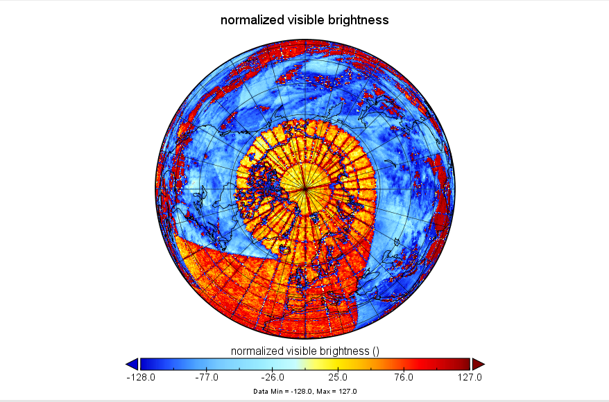 Calibrated visible satellite data (gnav) sample image
The NOAA Polar Orbiting Satellite (POES) Global Visible and Infrared Band Data from ESSA (1966 - 1972) and NOAA (1972 - 1978) Satellites data set, provided in NetCDF format, was created by scanning satellite images held in the NCEI Physical Archives. Data were scanned from either 35 mm film or paper photographs, then converted to NetCDF format with navigation information to improve accessibility and use in modern satellite applications. Data are mapped to a polar stereographic grid with a grid cell size of approximately 10 km. Visible and infrared data are available for both southern and northern hemispheres within this data collection but may not be available for all dates. Each scanned image's NetCDF file includes the raw scanned data, in addition to the processed imagery that has undergone pseudo-calibration and has been navigated to include location information. The original scans are archived via a separate Submission Agreement. Most of the scanning and all of the navigation and processing was done at the National Snow and Ice Data Center (NSIDC). The NOAA team at NSIDC maintains the User’s Guide documentation for this data set, and provides a link so that users who search NSIDC’s site will find the data set. The data are archived at and distributed by NCEI.
The ESSA satellites (ESSA-3, -5, -7, -9) were in operation from December 1966 through November 1972. They were equipped with the Advanced Vidicon Camera System (AVCS). In addition, ITOS-1 and NOAA-1 were equipped with the AVCS and were operational from January 1970 to August 1971. Only visible images are available during this time period. Quality varies throughout the 1960s time period. From October 1972 through March 1978, data from the NOAA satellites (NOAA-2, -3, -4, -5) were acquired. They were equipped with a Scanning Radiometer (SR) with both visible and infrared (IR) bands, so IR observations are available for this time period as well as visible. These were organized as cross-track scan lines.
The ESSA satellites (ESSA-3, -5, -7, -9) were in operation from December 1966 through November 1972. They were equipped with the Advanced Vidicon Camera System (AVCS). In addition, ITOS-1 and NOAA-1 were equipped with the AVCS and were operational from January 1970 to August 1971. Only visible images are available during this time period. Quality varies throughout the 1960s time period. From October 1972 through March 1978, data from the NOAA satellites (NOAA-2, -3, -4, -5) were acquired. They were equipped with a Scanning Radiometer (SR) with both visible and infrared (IR) bands, so IR observations are available for this time period as well as visible. These were organized as cross-track scan lines.
Dataset Citation
- Cite as: Campbell, G. Garrett, (2019): NOAA Polar Orbiting Satellite (POES) Global Visible and Infrared Band Data from ESSA (1966 - 1972) and NOAA (1972 - 1978) Satellites [indicate subset used]. NOAA National Centers for Environmental Information. doi:10.7289/V5QV3JV6 [access date].
Dataset Identifiers
- doi:10.7289/V5QV3JV6
- NCEI DSI 4001_01
- gov.noaa.ncdc:C01577
ISO 19115-2 Metadata
gov.noaa.ncdc:C01577
| Order Data |
|
| Distribution Formats |
|
| Ordering Instructions | Contact NCEI for other distribution options and instructions. |
| Distributor |
NOAA National Centers for Environmental Information ncei.info@noaa.gov |
| Dataset Point of Contact | Customer Engagement Branch NOAA National Centers for Environmental Information 1-828-271-4800 ncei.orders@noaa.gov |
| Time Period | 1966-12-01 to 1978-03-16 (time interval: 1-day) |
| Spatial Bounding Box Coordinates |
West: -180.0
East: 180.0
South: -90.0
North: 90.0
|
| Spatial Coverage Map |
| Dataset Information | |
| General Documentation |
|
| Processing Documents |
|
| Associated Resources |
|
| Publication Dates |
|
| Data Presentation Form | Digital image |
| Dataset Progress Status | Complete - production of the data has been completed |
| Data Update Frequency | As needed |
| Purpose | This data is useful for the study of weather and climate before the current satellite record. It may be useful for reanalysis studies, cloud climatologies, and special weather events. |
| Use Limitations |
|
| Dataset Citation |
|
| Cited Authors |
|
| Principal Investigators |
|
| Publishers |
|
| Theme keywords |
Global Change Master Directory (GCMD) Science Keywords
|
| Data Center keywords |
Global Change Master Directory (GCMD) Data Center Keywords
|
| Platform keywords |
Global Change Master Directory (GCMD) Platform Keywords
|
| Instrument keywords |
Global Change Master Directory (GCMD) Instrument Keywords
|
| Place keywords |
Global Change Master Directory (GCMD) Location Keywords
|
| Project keywords |
Global Change Master Directory (GCMD) Project Keywords
|
| Data Resolution keywords |
Global Change Master Directory (GCMD) Horizontal Data Resolution Keywords
|
| Stratum keywords |
Global Change Master Directory (GCMD) Location Keywords
|
| Use Constraints |
|
| Access Constraints |
|
| Fees |
|
| Lineage information for: dataset | |
|---|---|
| Lineage Statement | Original satellite data were collected by ESSA (later NOAA) and sent to the National Climatic Data Center (now NCEI) for stewardship. NSIDC then scanned the original imagery from physical media stored at NCEI, then digitized and applied navigation to the files. |
| Processor |
|
| Processing Documents |
|
| Source Datasets |
|
| Lineage information for: repository | |
|---|---|
| Processing Steps |
|
| Acquisition Information (collection) | |
|---|---|
| Instrument |
|
| Platform |
|
Last Modified: 2023-06-23
For questions about the information on this page, please email: ncei.info@noaa.gov
For questions about the information on this page, please email: ncei.info@noaa.gov