Automatic Identification System (AIS) in US Offshore Waters Vessel Traffic Data
US AIS; Marine Cadastre
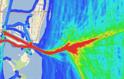 Ship Density Image from Miami
Vessel traffic data or Automatic Identification Systems (AIS) are a navigation safety device that transmits and monitors the location and characteristics of many vessels in U.S. and international waters in real-time. In the U.S. the Coast Guard and industry collect AIS data, which can also be used for a variety of coastal management purposes. NOAA and BOEM have worked jointly to make available these data from the U.S. Coast Guards national network of AIS receivers. The original records were filtered to a one-minute frequency rate and were subsetted to depict the location and description of vessels broadcasting within the Exclusive Economic Zone. MarineCadastre.gov AIS data are divided by month and Universal Transverse Mercator (UTM) zone.
- Cite as: Bureau of Ocean Energy Management (BOEM); National Oceanic and Atmospheric Administration (NOAA); Marine Cadastre. 2019. Automatic Identification System (AIS) in US Offshore Waters Vessel Traffic Data. Updated annually. [indicate subset used]. NOAA National Centers for Environmental Information. [access date].
- gov.noaa.ncdc:C01591
- NCEI DSI 1161_01
| Other Access |
-
NCEI Customer Support (offlineAccess)
This dataset is not currently available for public download from NCEI. Please contact NCEI to place a request for access to the archived data. The data can also be found via the Marine Cadastre AIS webpage, link is the documentation section.
|
| Distribution Formats |
|
| Ordering Instructions |
Contact NCEI for other distribution options and instructions. |
| Distributor |
NOAA National Centers for Environmental Information
ncei.info@noaa.gov
|
| Dataset Point of Contact |
Customer Engagement Branch
NOAA National Centers for Environmental Information
1-828-271-4800
ncei.orders@noaa.gov
|
| Time Period |
2015-01-01 to 2017-12-31 (time interval: 1-minute) |
| Spatial Reference System |
urn:ogc:def:crs:EPSG::4326 |
| Spatial Bounding Box Coordinates |
West: -180.0
East: 180.0
South: -90.0
North: 90.0
|
| Spatial Coverage Map |
|
| General Documentation |
|
| Associated Resources |
- MarineCadasatre.gov Automatic Identification System (AIS)
|
| Publication Dates |
- publication: 2018-08-08
- creation: 2018-06-28
|
| Data Presentation Form |
mapDigital
|
| Dataset Progress Status |
Ongoing - data is continually being updated |
| Data Update Frequency |
Annually |
| Purpose |
These data are intended for coastal and ocean use planning. To support coastal and ocean planning and other activities pursuant to the Energy Policy Act, Coastal Zone Management Act, Magnuson-Stevens Fishery Conservation and Management Act, National Environmental Policy Act, Rivers and Harbors Act and the Submerged Lands Act. |
| Use Limitations |
- These data are intended for coastal and ocean use planning. Not for navigation. https://marinecadastre.gov/about/disclaimer.html
|
| Dataset Citation |
- Cite as: Bureau of Ocean Energy Management (BOEM); National Oceanic and Atmospheric Administration (NOAA); Marine Cadastre. 2019. Automatic Identification System (AIS) in US Offshore Waters Vessel Traffic Data. Updated annually. [indicate subset used]. NOAA National Centers for Environmental Information. [access date].
|
| Cited Authors |
- National Oceanic and Atmospheric Administration (NOAA)
- Bureau of Ocean Energy Management (BOEM)
- MarineCadastre.gov Data Stewards
MarineCadastre.gov: Bureau of Ocean Energy Management and NOAA Office for Coastal Management
|
| Publishers |
- DOC/NOAA/NESDIS/NCEI > National Centers for Environmental Information, NESDIS, NOAA, U.S. Department of Commerce
|
| Theme keywords |
Global Change Master Directory (GCMD) Science Keywords- Earth Science > Human Dimensions > Environmental Governance/Management
Keyword Thesaurus Title
- AIS
- ship traffic
- vessel traffic
- vessel density
- Automatic Identification System
- navigation
|
| Data Center keywords |
Global Change Master Directory (GCMD) Data Center Keywords
- DOC/NOAA/NESDIS/NCEI > National Centers for Environmental Information, NESDIS, NOAA, U.S. Department of Commerce
- DOC/NOAA/NESDIS/NCDC > National Climatic Data Center, NESDIS, NOAA, U.S. Department of Commerce
|
| Place keywords |
Global Change Master Directory (GCMD) Location Keywords- Continent > North America > United States Of America
|
| Use Constraints |
- Cite as: Bureau of Ocean Energy Management (BOEM); National Oceanic and Atmospheric Administration (NOAA); Marine Cadastre. 2019. Automatic Identification System (AIS) in US Offshore Waters Vessel Traffic Data. Updated annually. [indicate subset used]. NOAA National Centers for Environmental Information. [access date].
- Use liability: NOAA and NCEI cannot provide any warranty as to the accuracy, reliability, or completeness of furnished data. Users assume responsibility to determine the usability of these data. The user is responsible for the results of any application of this data for other than its intended purpose.
|
| Access Constraints |
- Distribution liability: NOAA and NCEI make no warranty, expressed or implied, regarding these data, nor does the fact of distribution constitute such a warranty. NOAA and NCEI cannot assume liability for any damages caused by any errors or omissions in these data. If appropriate, NCEI can only certify that the data it distributes are an authentic copy of the records that were accepted for inclusion in the NCEI archives.
|
| Fees |
- In most cases, electronic downloads of the data are free. However, fees may apply for custom orders, data certifications, copies of analog materials, and data distribution on physical media.
|
| Lineage information for: dataset |
|---|
| Lineage Statement |
Two different processing steps are described below. One for the 2015-2017 AIS data in csv format and one for the 2009-2014 AIS data provided in file geodatabase format. |
| Processor |
- RPS Group Inc.
- RPS Group Inc.
|
| Processing Steps |
- For the 2015 - 2017 data: Filter the raw NMEA data to one-minute sample rate, select a subset of fields using MarineCadastre.gov NMEA to SQL Server processing tools. Load filtered records to SQL Server 2017 database using MarineCadastre.gov NMEA to SQL Server processing tools. Conduct quality and completeness check using logging results from the filter and loading process, and database record counts. Update the IMO, CallSign, VesselName, Length, Width, VesselType, and Draft from US Coast Guard AVIS. Added/ updated new vessel type code field to each record fragment that was found in the US Coast Guard AVIS. Export records from the SQL Server database to CSV files organized by month and UTM zone using MarineCadastre.gov Filter and Export utilities. Modify the format of date/time values to a UTC string format during export. Modify the format of the IMO vessel number to include the "IMO" prefix during export. Trim white space from string attributes during export. Replaced comma punctuation marks with a semi-colon in the vessel name or call sign field if present to improve CSV formatting during export. Replaced the vessel Status code values with descriptive text during export. Include a header record with descriptive text for each field during export. Write extracted AIS data to an ASCII CSV format file using MarineCadastre.gov Filter and Export utilities. Compress each ASCII CSV file.
Rationale: Convert raw NMEA data into open CSV file format.
- The data was divided spatially by UTM zone and aggregated temporally to monthly datasets using AISParser. The data was then converted to FGDB using the AIS data model created for this project and a custom script which implements AISParser and ArcObjects.
Rationale: Convert raw NMEA data into GIS-friendly file format.
|
| Source Datasets |
- 2015, 2016, and 2017 NAIS Database
- 2015, 2016, and 2017 NAIS Database
- Description of Source: U.S. Coast Guard Navigation Center raw NMEA data
- Temporal extent used: 2015-01-01 to 2017-12-31
- Spatial extent used: N:75 S:15 E:-60 W:-180
- 2009, 2010, 2011, 2012, 2013, and 2014 NAIS Database
|
| Lineage information for: repository |
|---|
| Processing Steps |
- 2015-04-22T00:00:00 - NOAA created the National Centers for Environmental Information (NCEI) by merging NOAA's National Climatic Data Center (NCDC), National Geophysical Data Center (NGDC), and National Oceanographic Data Center (NODC), including the National Coastal Data Development Center (NCDDC), per the Consolidated and Further Continuing Appropriations Act, 2015, Public Law 113-235. NCEI launched publicly on April 22, 2015.
|
Last Modified: 2023-06-23
For questions about the information on this page, please email:
ncei.info@noaa.gov