Automatic Identification System (AIS) in US Offshore Waters Vessel Traffic Data
- referenceSystemInfo
- identificationInfo
- distributionInfo
- dataQualityInfo
- dataQualityInfo
- metadataMaintenance
(MI_Metadata)
fileIdentifier: gov.noaa.ncdc:C01591
language: eng; USA
characterSet: (MD_CharacterSetCode) utf8
hierarchyLevel: (MD_ScopeCode) dataset
contact: (CI_ResponsibleParty)
organisationName: NOAA National Centers for Environmental Information
contactInfo: (CI_Contact)
address: (CI_Address)
electronicMailAddress: ncei.info@noaa.gov
onlineResource: (CI_OnlineResource)
linkage: https://www.ncei.noaa.gov/contact
name: NCEI Contact Information
description: Information for contacts at NCEI.
function: (CI_OnLineFunctionCode) information
role: (CI_RoleCode) pointOfContact
dateStamp: 2023-06-23
metadataStandardName: ISO 19115-2 Geographic Information - Metadata - Part 2: Extensions for Imagery and Gridded Data
metadataStandardVersion: ISO 19115-2:2009(E)
return to top
referenceSystemInfo: (MD_ReferenceSystem)
referenceSystemIdentifier: (RS_Identifier)
authority: (CI_Citation)
title: EPSG Geodetic Parameter Dataset Registry
date: (CI_Date)
date: 2008-11-12
dateType: (CI_DateTypeCode) publication
citedResponsibleParty: (CI_ResponsibleParty)
organisationName: International Association of Oil and Gas Producers (OGP) Geomatics Committee
contactInfo: (CI_Contact)
onlineResource: (CI_OnlineResource)
linkage: http://www.epsg-registry.org/
applicationProfile: Data Search Application
name: EPSG Geodetic Parameter Dataset Registry Application
description: Interface to the EPSG Geodetic Parameter Dataset Registry
function: (CI_OnLineFunctionCode) search
role: (CI_RoleCode) custodian
citedResponsibleParty: (CI_ResponsibleParty)
organisationName: International Association of Oil and Gas Producers (OGP) Geomatics Committee
contactInfo: (CI_Contact)
onlineResource: (CI_OnlineResource)
linkage: http://www.epsg-registry.org/export.htm?gml=urn:ogc:def:crs:EPSG::4326
applicationProfile: Download
name: Coordinate Reference System data in GML
description: Coordinate Reference System data in GML
function: (CI_OnLineFunctionCode) download
role: (CI_RoleCode) custodian
code: urn:ogc:def:crs:EPSG::4326
version: (unknown)
return to top
identificationInfo: (MD_DataIdentification)
citation: (CI_Citation)
title: Automatic Identification System (AIS) in US Offshore Waters Vessel Traffic Data
alternateTitle: US AIS; Marine Cadastre
date: (CI_Date)
date: 2018-08-08
dateType: (CI_DateTypeCode) publication
date: (CI_Date)
date: 2018-06-28
dateType: (CI_DateTypeCode) creation
identifier: (MD_Identifier)
code: gov.noaa.ncdc:C01591
identifier: (MD_Identifier)
code: NCEI DSI 1161_01
citedResponsibleParty: (CI_ResponsibleParty)
organisationName: DOC/NOAA/NESDIS/NCEI > National Centers for Environmental Information, NESDIS, NOAA, U.S. Department of Commerce
role: (CI_RoleCode) publisher
citedResponsibleParty: (CI_ResponsibleParty)
organisationName: National Oceanic and Atmospheric Administration (NOAA)
role: (CI_RoleCode) author
citedResponsibleParty: (CI_ResponsibleParty)
organisationName: Bureau of Ocean Energy Management (BOEM)
role: (CI_RoleCode) author
citedResponsibleParty: (CI_ResponsibleParty)
organisationName: MarineCadastre.gov: Bureau of Ocean Energy Management and NOAA Office for Coastal Management
positionName: MarineCadastre.gov Data Stewards
contactInfo: (CI_Contact)
phone: (CI_Telephone)
voice: 843-740-1202
address: (CI_Address)
electronicMailAddress: info@marinecadastre.gov
contactInstructions: email
role: (CI_RoleCode) author
presentationForm: (CI_PresentationFormCode) mapDigital
abstract: Vessel traffic data or Automatic Identification Systems (AIS) are a navigation safety device that transmits and monitors the location and characteristics of many vessels in U.S. and international waters in real-time. In the U.S. the Coast Guard and industry collect AIS data, which can also be used for a variety of coastal management purposes. NOAA and BOEM have worked jointly to make available these data from the U.S. Coast Guards national network of AIS receivers. The original records were filtered to a one-minute frequency rate and were subsetted to depict the location and description of vessels broadcasting within the Exclusive Economic Zone. MarineCadastre.gov AIS data are divided by month and Universal Transverse Mercator (UTM) zone.
purpose: These data are intended for coastal and ocean use planning. To support coastal and ocean planning and other activities pursuant to the Energy Policy Act, Coastal Zone Management Act, Magnuson-Stevens Fishery Conservation and Management Act, National Environmental Policy Act, Rivers and Harbors Act and the Submerged Lands Act.
status: (MD_ProgressCode) onGoing
pointOfContact: (CI_ResponsibleParty)
organisationName: NOAA National Centers for Environmental Information
positionName: Customer Engagement Branch
contactInfo: (CI_Contact)
phone: (CI_Telephone)
voice: 1-828-271-4800
facsimile: 1-828-271-4876
address: (CI_Address)
deliveryPoint: 151 Patton Avenue
deliveryPoint: Veach-Baley Federal Building, Room 468
city: Asheville
administrativeArea: NC
postalCode: 28801-5001
country: USA
electronicMailAddress: ncei.orders@noaa.gov
onlineResource: (CI_OnlineResource)
linkage: https://www.ncei.noaa.gov
protocol: HTTPS
applicationProfile: Web Browser
name: NOAA National Centers for Environmental Information (NCEI)
description: NCEI home page with information, data access and contact information.
function: (CI_OnLineFunctionCode) information
hoursOfService: 8:00 - 6:00 Eastern
role: (CI_RoleCode) pointOfContact
resourceMaintenance: (MD_MaintenanceInformation)
maintenanceAndUpdateFrequency: (MD_MaintenanceFrequencyCode) annually
graphicOverview: (MD_BrowseGraphic)
fileName: https://marinecadastre.gov/img/ship_density_sm.png
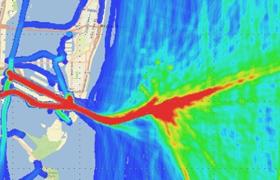
fileDescription: Ship Density Image from Miami
fileType: PNG
descriptiveKeywords: (MD_Keywords)
keyword: Earth Science > Human Dimensions > Environmental Governance/Management
type: (MD_KeywordTypeCode) theme
thesaurusName: (CI_Citation)
title: Global Change Master Directory (GCMD) Science Keywords
date: (CI_Date)
date: 2018
dateType: (CI_DateTypeCode) revision
edition: Version 8.6
citedResponsibleParty: (CI_ResponsibleParty)
organisationName: Global Change Data Center, Science and Exploration Directorate, Goddard Space Flight Center (GSFC) National Aeronautics and Space Administration (NASA)
contactInfo: (CI_Contact)
onlineResource: (CI_OnlineResource)
linkage: https://earthdata.nasa.gov/about/gcmd/global-change-master-directory-gcmd-keywords
protocol: HTTPS
applicationProfile: Web Browser
name: Global Change Master Directory (GCMD) Keywords
description: The information provided on this page seeks to define how the GCMD Keywords are structured, used and accessed. It also provides information on how users can participate in the further development of the keywords.
function: (CI_OnLineFunctionCode) information
role: (CI_RoleCode) publisher
descriptiveKeywords: (MD_Keywords)
keyword: Continent > North America > United States Of America
type: (MD_KeywordTypeCode) place
thesaurusName: (CI_Citation)
title: Global Change Master Directory (GCMD) Location Keywords
date: (CI_Date)
date: 2018
dateType: (CI_DateTypeCode) revision
edition: Version 8.6
citedResponsibleParty: (CI_ResponsibleParty)
organisationName: Global Change Data Center, Science and Exploration Directorate, Goddard Space Flight Center (GSFC) National Aeronautics and Space Administration (NASA)
contactInfo: (CI_Contact)
onlineResource: (CI_OnlineResource)
linkage: https://earthdata.nasa.gov/about/gcmd/global-change-master-directory-gcmd-keywords
protocol: HTTPS
applicationProfile: Web Browser
name: Global Change Master Directory (GCMD) Keywords
description: The information provided on this page seeks to define how the GCMD Keywords are structured, used and accessed. It also provides information on how users can participate in the further development of the keywords.
function: (CI_OnLineFunctionCode) information
role: (CI_RoleCode) publisher
descriptiveKeywords: (MD_Keywords)
keyword:
keyword: DOC/NOAA/NESDIS/NCEI > National Centers for Environmental Information, NESDIS, NOAA, U.S. Department of Commerce
keyword: DOC/NOAA/NESDIS/NCDC > National Climatic Data Center, NESDIS, NOAA, U.S. Department of Commerce
type: (MD_KeywordTypeCode) dataCentre
thesaurusName: (CI_Citation)
title: Global Change Master Directory (GCMD) Data Center Keywords
date: (CI_Date)
date: 2018
dateType: (CI_DateTypeCode) revision
edition: Version 8.6
citedResponsibleParty: (CI_ResponsibleParty)
organisationName: Global Change Data Center, Science and Exploration Directorate, Goddard Space Flight Center (GSFC) National Aeronautics and Space Administration (NASA)
contactInfo: (CI_Contact)
onlineResource: (CI_OnlineResource)
linkage: https://earthdata.nasa.gov/about/gcmd/global-change-master-directory-gcmd-keywords
protocol: HTTPS
applicationProfile: Web Browser
name: Global Change Master Directory (GCMD) Keywords
description: The information provided on this page seeks to define how the GCMD Keywords are structured, used and accessed. It also provides information on how users can participate in the further development of the keywords.
function: (CI_OnLineFunctionCode) information
role: (CI_RoleCode) publisher
descriptiveKeywords: (MD_Keywords)
keyword: AIS
keyword: ship traffic
keyword: vessel traffic
keyword: vessel density
keyword: Automatic Identification System
keyword: navigation
type: (MD_KeywordTypeCode) theme
thesaurusName: (CI_Citation)
title: Keyword Thesaurus Title
date: (missing)
resourceConstraints: (MD_Constraints)
useLimitation: These data are intended for coastal and ocean use planning. Not for navigation. https://marinecadastre.gov/about/disclaimer.html
resourceConstraints: (MD_LegalConstraints)
useConstraints: (MD_RestrictionCode) otherRestrictions
otherConstraints: Cite as: Bureau of Ocean Energy Management (BOEM); National Oceanic and Atmospheric Administration (NOAA); Marine Cadastre. 2019. Automatic Identification System (AIS) in US Offshore Waters Vessel Traffic Data. Updated annually. [indicate subset used]. NOAA National Centers for Environmental Information. [access date].
resourceConstraints: (MD_LegalConstraints)
accessConstraints: (MD_RestrictionCode) otherRestrictions
otherConstraints: Distribution liability: NOAA and NCEI make no warranty, expressed or implied, regarding these data, nor does the fact of distribution constitute such a warranty. NOAA and NCEI cannot assume liability for any damages caused by any errors or omissions in these data. If appropriate, NCEI can only certify that the data it distributes are an authentic copy of the records that were accepted for inclusion in the NCEI archives.
resourceConstraints: (MD_LegalConstraints)
useConstraints: (MD_RestrictionCode) otherRestrictions
otherConstraints: Use liability: NOAA and NCEI cannot provide any warranty as to the accuracy, reliability, or completeness of furnished data. Users assume responsibility to determine the usability of these data. The user is responsible for the results of any application of this data for other than its intended purpose.
aggregationInfo: (MD_AggregateInformation)
aggregateDataSetName: (CI_Citation)
title: MarineCadasatre.gov Automatic Identification System (AIS)
date: (CI_Date)
date: 2009
dateType: (CI_DateTypeCode) creation
citedResponsibleParty: (CI_ResponsibleParty)
organisationName: National Oceanic and Atmospheric Administration (NOAA)
role: (CI_RoleCode) publisher
citedResponsibleParty: (CI_ResponsibleParty)
organisationName: Bureau of Ocean Energy Management (BOEM)
role: (CI_RoleCode) publisher
citedResponsibleParty: (CI_ResponsibleParty)
organisationName: (missing)
contactInfo: (CI_Contact)
onlineResource: (CI_OnlineResource)
linkage: https://marinecadastre.gov/ais/
protocol: HTTPS
applicationProfile: Web Browser
name: MarineCadasatre.gov Main AIS page
description: MarineCadastre.gov website to download AIS data.
role: (missing)
associationType: (DS_AssociationTypeCode) source
initiativeType: (DS_InitiativeTypeCode) collection
spatialRepresentationType: (MD_SpatialRepresentationTypeCode) vector
language: eng; USA
topicCategory: (MD_TopicCategoryCode) climatologyMeteorologyAtmosphere
topicCategory: (MD_TopicCategoryCode) oceans
topicCategory: (MD_TopicCategoryCode) transportation
extent: (EX_Extent)
geographicElement: (EX_GeographicBoundingBox)
extentTypeCode: 1
westBoundLongitude: -180.0
eastBoundLongitude: 180.0
southBoundLatitude: -90.0
northBoundLatitude: 90.0
temporalElement: (EX_TemporalExtent)
extent:
TimePeriod:
description: ground condition
beginPosition: 2015-01-01
endPosition: 2017-12-31
timeInterval: 1
return to top
distributionInfo: (MD_Distribution)
distributor: (MD_Distributor)
distributorContact: (CI_ResponsibleParty)
organisationName: NOAA National Centers for Environmental Information
contactInfo: (CI_Contact)
address: (CI_Address)
electronicMailAddress: ncei.info@noaa.gov
onlineResource: (CI_OnlineResource)
linkage: https://www.ncei.noaa.gov/contact
name: NCEI Contact Information
description: Information for contacts at NCEI.
function: (CI_OnLineFunctionCode) information
role: (CI_RoleCode) distributor
distributionOrderProcess: (MD_StandardOrderProcess)
fees: In most cases, electronic downloads of the data are free. However, fees may apply for custom orders, data certifications, copies of analog materials, and data distribution on physical media.
orderingInstructions: Contact NCEI for other distribution options and instructions.
distributorFormat: (MD_Format)
name: CSV
version: (missing)
distributorFormat: (MD_Format)
name: HTML
version: (missing)
distributorFormat: (MD_Format)
name: HTML
version: (missing)
distributorTransferOptions: (MD_DigitalTransferOptions)
onLine: (CI_OnlineResource)
linkage: https://www.ncei.noaa.gov/metadata/geoportal/rest/metadata/item/gov.noaa.ncdc:C01591/html
protocol: HTTPS
applicationProfile: Landing Page
name: NCEI Dataset Landing Page
description: Landing page for the dataset.
function: (CI_OnLineFunctionCode) information
distributorTransferOptions: (MD_DigitalTransferOptions)
transferSize: (missing)
onLine: (CI_OnlineResource)
linkage: https://www.ncei.noaa.gov/contact
protocol: HTTPS
applicationProfile: Web Browser
name: NCEI Customer Support
description: This dataset is not currently available for public download from NCEI. Please contact NCEI to place a request for access to the archived data. The data can also be found via the Marine Cadastre AIS webpage, link is the documentation section.
function: (CI_OnLineFunctionCode) offlineAccess
distributorTransferOptions: (MD_DigitalTransferOptions)
transferSize: (missing)
onLine: (CI_OnlineResource)
linkage: https://marinecadastre.gov/ais/faq/
protocol: HTTPS
applicationProfile: Documentation
name: Marine Cadastre Website FAQ Page
description: FAQ on how to use the data
function: (CI_OnLineFunctionCode) information
distributorTransferOptions: (MD_DigitalTransferOptions)
transferSize: (missing)
onLine: (CI_OnlineResource)
linkage: https://navcen.uscg.gov/?pageName=AISMessages
protocol: HTTPS
applicationProfile: Information
name: USCG Navigation Center AIS Messages
description: The data variables of AIS published by the U.S. Coast Guard NAVCEN
function: (CI_OnLineFunctionCode) information
return to top
dataQualityInfo: (DQ_DataQuality)
scope: (DQ_Scope)
level: (MD_ScopeCode) dataset
extent: #boundingExtent
lineage: (LI_Lineage)
statement: Two different processing steps are described below. One for the 2015-2017 AIS data in csv format and one for the 2009-2014 AIS data provided in file geodatabase format.
processStep: (LE_ProcessStep)
description: For the 2015 - 2017 data: Filter the raw NMEA data to one-minute sample rate, select a subset of fields using MarineCadastre.gov NMEA to SQL Server processing tools. Load filtered records to SQL Server 2017 database using MarineCadastre.gov NMEA to SQL Server processing tools. Conduct quality and completeness check using logging results from the filter and loading process, and database record counts. Update the IMO, CallSign, VesselName, Length, Width, VesselType, and Draft from US Coast Guard AVIS. Added/ updated new vessel type code field to each record fragment that was found in the US Coast Guard AVIS. Export records from the SQL Server database to CSV files organized by month and UTM zone using MarineCadastre.gov Filter and Export utilities. Modify the format of date/time values to a UTC string format during export. Modify the format of the IMO vessel number to include the "IMO" prefix during export. Trim white space from string attributes during export. Replaced comma punctuation marks with a semi-colon in the vessel name or call sign field if present to improve CSV formatting during export. Replaced the vessel Status code values with descriptive text during export. Include a header record with descriptive text for each field during export. Write extracted AIS data to an ASCII CSV format file using MarineCadastre.gov Filter and Export utilities. Compress each ASCII CSV file.
rationale: Convert raw NMEA data into open CSV file format.
dateTime: (missing)
processor: (CI_ResponsibleParty)
organisationName: RPS Group Inc.
role: (CI_RoleCode) processor
source: sd001
processStep: (LE_ProcessStep)
description: The data was divided spatially by UTM zone and aggregated temporally to monthly datasets using AISParser. The data was then converted to FGDB using the AIS data model created for this project and a custom script which implements AISParser and ArcObjects.
rationale: Convert raw NMEA data into GIS-friendly file format.
dateTime: (missing)
processor: (CI_ResponsibleParty)
organisationName: RPS Group Inc.
role: (CI_RoleCode) processor
source: sd002
source: (LE_Source)
description: U.S. Coast Guard Navigation Center raw NMEA data
sourceCitation: (CI_Citation)
title: 2015, 2016, and 2017 NAIS Database
date: (CI_Date)
date: 2017-12-31
dateType: (CI_DateTypeCode) publication
citedResponsibleParty: (CI_ResponsibleParty)
organisationName: U.S Coast Guard
role: (CI_RoleCode) resourceProvider
citedResponsibleParty: (CI_ResponsibleParty)
organisationName: (missing)
contactInfo: (CI_Contact)
onlineResource: (CI_OnlineResource)
linkage: https://www.navcen.uscg.gov/
protocol: HTTPS
applicationProfile: Web Browser
name: 2015, 2016, and 2017 NAIS Database
function: (CI_OnLineFunctionCode) information
role: (missing)
sourceExtent: (EX_Extent)
geographicElement: (EX_GeographicBoundingBox)
extentTypeCode: 1
westBoundLongitude: -180
eastBoundLongitude: -60
southBoundLatitude: 15
northBoundLatitude: 75
temporalElement: (EX_TemporalExtent)
extent:
TimePeriod:
beginPosition: 2015-01-01
endPosition: 2017-12-31
sourceStep: ps001
source: (LE_Source)
description: U.S. Coast Guard Navigation Center raw NMEA data
sourceCitation: (CI_Citation)
title: 2009, 2010, 2011, 2012, 2013, and 2014 NAIS Database
date: (CI_Date)
date: 2014-12-31
dateType: (CI_DateTypeCode) publication
citedResponsibleParty: (CI_ResponsibleParty)
organisationName: U.S Coast Guard
role: (CI_RoleCode) resourceProvider
citedResponsibleParty: (CI_ResponsibleParty)
organisationName: (missing)
contactInfo: (CI_Contact)
onlineResource: (CI_OnlineResource)
linkage: https://www.navcen.uscg.gov/
protocol: HTTPS
applicationProfile: Web Browser
name: 2009, 2010, 2011, 2012, 2013, and 2014 NAIS Database
function: (CI_OnLineFunctionCode) information
role: (missing)
sourceExtent: (EX_Extent)
geographicElement: (EX_GeographicBoundingBox)
extentTypeCode: 1
westBoundLongitude: -180
eastBoundLongitude: -60
southBoundLatitude: 15
northBoundLatitude: 75
temporalElement: (EX_TemporalExtent)
extent:
TimePeriod:
beginPosition: 2009-01-01
endPosition: 2014-12-31
sourceStep: ps002
return to top
dataQualityInfo: (DQ_DataQuality)
scope: (DQ_Scope)
level: (MD_ScopeCode) repository
levelDescription: (MD_ScopeDescription)
other: NOAA National Centers for Environmental Information
lineage: (LI_Lineage)
processStep: (LE_ProcessStep)
description: NOAA created the National Centers for Environmental Information (NCEI) by merging NOAA's National Climatic Data Center (NCDC), National Geophysical Data Center (NGDC), and National Oceanographic Data Center (NODC), including the National Coastal Data Development Center (NCDDC), per the Consolidated and Further Continuing Appropriations Act, 2015, Public Law 113-235. NCEI launched publicly on April 22, 2015.
dateTime:
DateTime: 2015-04-22T00:00:00
return to top
metadataMaintenance: (MD_MaintenanceInformation)
maintenanceAndUpdateFrequency: (MD_MaintenanceFrequencyCode) asNeeded
maintenanceNote: Bulk metadata change applied on 2023-06-23. See version control repository history for metadata change details.