NOAA 0.25-degree Daily Optimum Interpolation Sea Surface Temperature (OISST), Version 2.1
Sea Surface Temperature - Optimum Interpolation
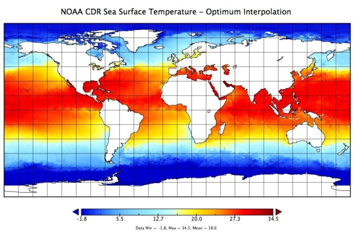 Sea Surface Temperature image
This high-resolution sea surface temperature (SST) analysis product was developed using an optimum interpolation (OI) technique. The OISST analysis has a spatial grid resolution of 0.25 degree and temporal resolution of 1 day, spanning from September 1981 to present. The analysis was constructed by combining observations from different platforms on a regular global grid, including Advanced Very High Resolution Radiometer (AVHRR) satellite data, ships, buoys and Argo floats. A spatially complete SST map was produced by interpolating to fill in spatial gaps. The methodology includes bias adjustment of satellite and ship observations (referenced to buoys) to compensate for platform differences and sensor biases. This proved critical during the Mt. Pinatubo eruption in 1991, when the widespread presence of volcanic aerosols resulted in infrared satellite temperatures that were much cooler than actual ocean temperatures, and other degradation of satellite observations. Released in March 2020, Version 2.1 supersedes the previous Version 2. For the January 2016 to present time period, changes include: 1) In-Situ ship and buoy data changed from the NCEP Traditional Alphanumeric Codes (TAC) to the NCEI merged TAC + Binary Universal Form for the Representation (BUFR) data; 2) Addition of Argo float observed SST data; 3) Satellite input changed from METOP-A and NOAA-19 to METOP-A and METOP-B; 4) Revised ship-buoy SST corrections and revised sea-ice-concentration to SST conversion. The data before January 1, 2016 remain the same as Version 2.0. Preliminary product files are produced daily in near real-time (1-day latency) and can be updated in the first few days if critical input data become available after the initial production time. After two weeks, a complete or final product is generated and archived with no additional changes expected. The product is available in netCDF-4 with metadata attributes.
Dataset Citation
- Cite as: Huang, Boyin; Liu, Chunying; Banzon, Viva F.; Freeman, Eric; Graham, Garrett; Hankins, William; Smith, Thomas M.; Zhang, Huai-Min. (2020): NOAA 0.25-degree Daily Optimum Interpolation Sea Surface Temperature (OISST), Version 2.1. [indicate subset used]. NOAA National Centers for Environmental Information. https://doi.org/10.25921/RE9P-PT57. Accessed [date].
Dataset Identifiers
- doi:10.25921/RE9P-PT57
- NCEI DSI 3650_02
- gov.noaa.ncdc:C01606
ISO 19115-2 Metadata
gov.noaa.ncdc:C01606
| Download Data |
|
| Distribution Formats |
|
| Ordering Instructions | Contact NCEI for other distribution options and instructions. |
| Distributor |
NOAA National Centers for Environmental Information ncei.info@noaa.gov |
| Dataset Point of Contact | Customer Engagement Branch DOC/NOAA/NESDIS/NCEI > National Centers for Environmental Information, NESDIS, NOAA, U.S. Department of Commerce +1 (828) 271-4800 oisst_contacts@noaa.gov |
| Dataset Point of Contact | OISST Product Team DOC/NOAA/NESDIS/NCEI > National Centers for Environmental Information, NESDIS, NOAA, U.S. Department of Commerce oisst-help@noaa.gov |
| Time Period | 1981-09-01 to Present (time interval: 1-day) |
| Spatial Bounding Box Coordinates |
West: -180.0
East: 180.0
South: -90.0
North: 90.0
|
| Spatial Coverage Map |
| General Documentation |
|
| Processing Documents |
|
| Associated Resources |
|
| Publication Dates |
|
| Edition | Version 2.1 |
| Data Presentation Form | Digital image |
| Dataset Progress Status | Ongoing - data is continually being updated |
| Data Update Frequency | Daily |
| Purpose | The NOAA Daily 0.25 degree Optimum Interpolation Sea Surface Temperature (OISST) provides complete ocean temperature fields constructed by combining bias-adjusted observations from different platforms (satellite, ships, buoys) on a regular global grid, with gaps filled in by interpolation. Applications include climate and oceanographic research, marine environmental and coastal applications including marine ecosystems and fisheries. |
| Dataset Citation |
|
| Cited Authors |
|
| Principal Investigators |
|
| Contributors |
|
| Publishers |
|
| Theme keywords |
Global Change Master Directory (GCMD) Science Keywords
|
| Data Center keywords |
Global Change Master Directory (GCMD) Data Center Keywords
|
| Instrument keywords |
Global Change Master Directory (GCMD) Instrument Keywords
|
| Place keywords |
Global Change Master Directory (GCMD) Location Keywords
|
| Stratum keywords |
Global Change Master Directory (GCMD) Location Keywords
|
| Use Constraints |
|
| Access Constraints |
|
| Fees |
|
| Lineage information for: dataset | |
|---|---|
| Lineage Statement | This dataset was produced by and is archived at the NOAA National Centers for Environmental Information (NCEI). |
| Processor |
|
| Processing Steps |
|
| Processing Documents |
|
| Source Datasets |
|
| Lineage information for: repository | |
|---|---|
| Processing Steps |
|
Last Modified: 2023-08-10
For questions about the information on this page, please email: ncei.info@noaa.gov
For questions about the information on this page, please email: ncei.info@noaa.gov