Marine Geology Reports in the NGDC Archive
- spatialRepresentationInfo
- referenceSystemInfo
- identificationInfo
- identificationInfo
- contentInfo
- contentInfo
- contentInfo
- distributionInfo
- dataQualityInfo
- dataQualityInfo
- metadataMaintenance
- acquisitionInformation
(MI_Metadata)
fileIdentifier: gov.noaa.ngdc.mgg.geology:G00502
hierarchyLevel: (MD_ScopeCode) dataset
contact: (CI_ResponsibleParty)
organisationName: NOAA National Centers for Environmental Information
contactInfo: (CI_Contact)
address: (CI_Address)
electronicMailAddress: ncei.info@noaa.gov
onlineResource: (CI_OnlineResource)
linkage: https://www.ncei.noaa.gov/contact
name: NCEI Contact Information
description: Information for contacts at NCEI.
function: (CI_OnLineFunctionCode) information
role: (CI_RoleCode) pointOfContact
dateStamp: 2020-04-21
metadataStandardName: ISO 19115-2 Geographic Information - Metadata - Part 2: Extensions for Imagery and Gridded Data
metadataStandardVersion: ISO 19115-2:2009(E)
return to top
spatialRepresentationInfo: (MD_VectorSpatialRepresentation)
geometricObjects: (MD_GeometricObjects)
geometricObjectType: (MD_GeometricObjectTypeCode) point
return to top
referenceSystemInfo: (MD_ReferenceSystem)
referenceSystemIdentifier: (RS_Identifier)
authority: (CI_Citation)
title: European Petroleum Survey Group (EPSG) Geodetic Parameter Registry
date: (CI_Date)
date: 2008-11-12
dateType: (CI_DateTypeCode) publication
citedResponsibleParty: (CI_ResponsibleParty)
organisationName: European Petroleum Survey Group
contactInfo: (CI_Contact)
onlineResource: (CI_OnlineResource)
linkage: http://www.epsg-registry.org/
name: European Petroleum Survey Group Geodetic Parameter Dataset
description: Registry that accesses the EPSG Geodetic Parameter Dataset, which is a structured dataset of Coordinate Reference Systems and Coordinate Transformations.
function: (CI_OnLineFunctionCode) search
role: (inapplicable)
code: urn:ogc:def:crs:EPSG:4326
version: 6.18.3
return to top
identificationInfo: (MD_DataIdentification)
citation: (CI_Citation)
title: Marine Geology Reports in the NGDC Archive
date: (CI_Date)
date: 1976-01-01
dateType: (CI_DateTypeCode) publication
date: (CI_Date)
date: 2015-06-01
dateType: (CI_DateTypeCode) revision
identifier: (MD_Identifier)
authority: (CI_Citation)
title: NOAA National Centers for Environmental Information
date: (inapplicable)
code: NCEI Metadata ID: gov.noaa.ngdc.mgg.geology:G00502
citedResponsibleParty: (CI_ResponsibleParty)
individualName:
organisationName: Multiple Investigators
role: (CI_RoleCode) author
citedResponsibleParty: (CI_ResponsibleParty)
organisationName: NOAA National Centers for Environmental Information
role: (CI_RoleCode) publisher
presentationForm: (CI_PresentationFormCode) imageDigital
series: (CI_Series)
name: Marine Geology and Geophysics (MGG)
issueIdentification: Multiple MGG identifiers
abstract: Historic Marine Geologic data reports available are from academia, government, and non-U.S. sources. These reports were originally in paper or film form and were scanned to Portable Document Format (PDF) to enable online browse/download and archive in digital form. The following are examples of the types of analyses of sediment or rock from the ocean floor or lakebeds worldwide which may be included in individual data reports: descriptions of composition and/or lithology, grain size and other physical properties, mineralogy, geochemistry, paleontology, petrology, paleomagnetism and acoustics of sediment. They may also contain low-resolution photographs of cores or dredges, or the ocean floor. Reports are searchable via the Marine Geology Digital Inventory and may also be linked to/discoverable via the Index to Marine and Lacustrine Geological Samples (IMLGS). Scanned images of most paper data reports are available to view online, however, some Copyrighted reports contributed through the World Data Center System are available for on-site inspection only. For these reports, the geologic inventory provides links to the contributing institution for ordering.
purpose: Marine Geological and Geophysical Research and Environmental Studies
credit: Credit the source of the original data set.
status: (MD_ProgressCode) completed
status: (MD_ProgressCode) historicalArchive
pointOfContact: (CI_ResponsibleParty)
organisationName: NOAA National Centers for Environmental Information
contactInfo: (CI_Contact)
address: (CI_Address)
electronicMailAddress: ncei.info@noaa.gov
onlineResource: (CI_OnlineResource)
linkage: https://www.ncei.noaa.gov/contact
name: NCEI Contact Information
description: Information for contacts at NCEI.
function: (CI_OnLineFunctionCode) information
role: (CI_RoleCode) pointOfContact
pointOfContact: (CI_ResponsibleParty)
organisationName: NOAA National Centers for Environmental Information
positionName: Marine Geology Data Manager
contactInfo: (CI_Contact)
address: (CI_Address)
deliveryPoint: 325 Broadway, Mail Code E/NE42
city: Boulder
administrativeArea: CO
postalCode: 80305-3328
country: USA
electronicMailAddress: geology.info@noaa.gov
role: (CI_RoleCode) pointOfContact
resourceMaintenance: (MD_MaintenanceInformation)
maintenanceAndUpdateFrequency: (MD_MaintenanceFrequencyCode) irregular
maintenanceNote: Additions as new reports are received.
graphicOverview: (MD_BrowseGraphic)
fileName: https://www.ngdc.noaa.gov/mgg/image/marine_geology_map200x165.png
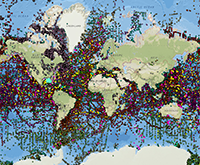
fileDescription: data locations
fileType: PNG
descriptiveKeywords: (MD_Keywords)
keyword: Unknown
keyword: ICSU-WDS > International Council for Science - World Data System
type: (MD_KeywordTypeCode) project
thesaurusName: (CI_Citation)
title: Global Change Master Directory (GCMD) Project Keywords
date: (CI_Date)
date: 2020-01-09
dateType: (CI_DateTypeCode) publication
edition: 9.1
citedResponsibleParty: (CI_ResponsibleParty)
organisationName: NASA Goddard Space Flight Center, Earth Science Data and Information System
contactInfo: (CI_Contact)
onlineResource: (CI_OnlineResource)
linkage: https://www.earthdata.nasa.gov/learn/find-data/idn/gcmd-keywords
name: Global Change Master Directory (GCMD) Keywords
description: The information provided on this page seeks to define how the GCMD Keywords are structured, used and accessed. It also provides information on how users can participate in the further development of the keywords.
function: (CI_OnLineFunctionCode) information
role: (CI_RoleCode) custodian
descriptiveKeywords: (MD_Keywords)
keyword: Scientific archives
keyword: Electronic records
keyword: Oceanography
keyword: Ocean bottom
keyword: Geology
keyword: Submarine geology
keyword: Marine sediments
type: (MD_KeywordTypeCode) theme
thesaurusName: (CI_Citation)
title: Library of Congress Subject Headings
date: (unknown)
citedResponsibleParty: (CI_ResponsibleParty)
organisationName: US Library of Congress
contactInfo: (CI_Contact)
onlineResource: (CI_OnlineResource)
linkage: http://id.loc.gov/authorities/subjects
protocol: http
applicationProfile: web browser
name: Library of Congress Subject Headings (LCSH)
description: The Library of Congress Subject Headings (LCSH) are part of a Linked Data Service, actively maintained since 1898 to catalog materials held at the Library of Congress.
function: (CI_OnLineFunctionCode) information
role: (CI_RoleCode) resourceProvider
descriptiveKeywords: (MD_Keywords)
keyword: Marine geology
type: (MD_KeywordTypeCode) theme
thesaurusName: (CI_Citation)
title: SeaDataNet Common Vocabularies
date: (unknown)
citedResponsibleParty: (CI_ResponsibleParty)
organisationName: SeaDataNet
contactInfo: (CI_Contact)
onlineResource: (CI_OnlineResource)
linkage: http://www.seadatanet.org/Standards-Software/Common-Vocabularies
protocol: http
applicationProfile: web browser
name: SeaDataNet Common Vocabularies
description: The SeaDataNet Vocabulary Server is populated with lists describing a wide range of entities relevant to marine metadata and data such as parameters, sea area names, platform classes, instrument types, and so on.
function: (CI_OnLineFunctionCode) information
role: (CI_RoleCode) resourceProvider
descriptiveKeywords: (MD_Keywords)
keyword: Sea-floor characteristics
type: (MD_KeywordTypeCode) theme
thesaurusName: (CI_Citation)
title: USGS Science Topics
date: (unknown)
citedResponsibleParty: (CI_ResponsibleParty)
organisationName: US Geological Survey
contactInfo: (CI_Contact)
onlineResource: (CI_OnlineResource)
linkage: https://www2.usgs.gov/science/about/
protocol: http
applicationProfile: web browser
name: USGS Thesaurus
description: The USGS Thesaurus contains thematic terms for categorizing information resources intended to support finding and understanding scientific information.
function: (CI_OnLineFunctionCode) information
role: (CI_RoleCode) resourceProvider
descriptiveKeywords: (MD_Keywords)
keyword: Earth Science > Oceans > Marine Sediments > Geotechnical Properties
keyword: Earth Science > Oceans > Marine Sediments > Sediment Chemistry
keyword: Earth Science > Oceans > Marine Sediments > Sediment Composition
keyword: Earth Science > Oceans > Marine Sediments > Sedimentary Textures
keyword: Earth Science > Paleoclimate > Ocean/Lake Records > Boreholes
keyword: Earth Science > Paleoclimate > Ocean/Lake Records > Isotopes
keyword: Earth Science > Paleoclimate > Ocean/Lake Records > Microfossils
keyword: Earth Science > Paleoclimate > Ocean/Lake Records > Paleomagnetic Data
keyword: Earth Science > Paleoclimate > Ocean/Lake Records > Sediments
keyword: Earth Science > Solid Earth > Rocks/Minerals/Crystals > Major Elements
keyword: Earth Science > Solid Earth > Rocks/Minerals/Crystals > Minor Elements
keyword: Earth Science > Solid Earth > Rocks/Minerals/Crystals > Trace Elements
keyword: Earth Science > Solid Earth > Geomagnetism > Paleomagnetism
keyword: Earth Science > Solid Earth > Rocks/Minerals/Crystals > Age Determinations
keyword: Earth Science > Solid Earth > Rocks/Minerals/Crystals > Igneous Rocks
keyword: Earth Science > Solid Earth > Rocks/Minerals/Crystals > Metamorphic Rocks
keyword: Earth Science > Solid Earth > Rocks/Minerals/Crystals > Sedimentary Rocks
keyword: Earth Science > Solid Earth > Rocks/Minerals/Crystals > Sediments
keyword: Earth Science > OCEANS > Marine Sediments > Stratigraphic Sequence
keyword: Earth Science > PALEOCLIMATE > Ocean/Lake Records > Stratigraphic Sequence
type: (MD_KeywordTypeCode) theme
thesaurusName: (CI_Citation)
title: Global Change Master Directory (GCMD) Science Keywords
date: (CI_Date)
date: 2020-01-09
dateType: (CI_DateTypeCode) publication
edition: 9.1
citedResponsibleParty: (CI_ResponsibleParty)
organisationName: NASA Goddard Space Flight Center, Earth Science Data and Information System
contactInfo: (CI_Contact)
onlineResource: (CI_OnlineResource)
linkage: https://www.earthdata.nasa.gov/learn/find-data/idn/gcmd-keywords
name: Global Change Master Directory (GCMD) Keywords
description: The information provided on this page seeks to define how the GCMD Keywords are structured, used and accessed. It also provides information on how users can participate in the further development of the keywords.
function: (CI_OnLineFunctionCode) information
role: (CI_RoleCode) custodian
descriptiveKeywords: (MD_Keywords)
keyword: In Situ Ocean-based Platforms > Ships
type: (MD_KeywordTypeCode) platform
thesaurusName: (CI_Citation)
title: Global Change Master Directory (GCMD) Platform Keywords
date: (CI_Date)
date: 2020-01-09
dateType: (CI_DateTypeCode) publication
edition: 9.1
citedResponsibleParty: (CI_ResponsibleParty)
organisationName: NASA Goddard Space Flight Center, Earth Science Data and Information System
contactInfo: (CI_Contact)
onlineResource: (CI_OnlineResource)
linkage: https://www.earthdata.nasa.gov/learn/find-data/idn/gcmd-keywords
name: Global Change Master Directory (GCMD) Keywords
description: The information provided on this page seeks to define how the GCMD Keywords are structured, used and accessed. It also provides information on how users can participate in the further development of the keywords.
function: (CI_OnLineFunctionCode) information
role: (CI_RoleCode) custodian
descriptiveKeywords: (MD_Keywords)
keyword: In Situ/Laboratory Instruments > Corers > Coring Devices
keyword: In Situ/Laboratory Instruments > Samplers > Dredging Devices
keyword: In Situ/Laboratory Instruments > Samplers > Grabbers/Traps/Collectors > Grab Samplers
keyword: In Situ/Laboratory Instruments > Corers > ROCK CORERS
keyword: In Situ/Laboratory Instruments > Corers > Sediment Corers
type: (MD_KeywordTypeCode) instrument
thesaurusName: (CI_Citation)
title: Global Change Master Directory (GCMD) Instrument Keywords
date: (CI_Date)
date: 2020-01-09
dateType: (CI_DateTypeCode) publication
edition: 9.1
citedResponsibleParty: (CI_ResponsibleParty)
organisationName: NASA Goddard Space Flight Center, Earth Science Data and Information System
contactInfo: (CI_Contact)
onlineResource: (CI_OnlineResource)
linkage: https://www.earthdata.nasa.gov/learn/find-data/idn/gcmd-keywords
name: Global Change Master Directory (GCMD) Keywords
description: The information provided on this page seeks to define how the GCMD Keywords are structured, used and accessed. It also provides information on how users can participate in the further development of the keywords.
function: (CI_OnLineFunctionCode) information
role: (CI_RoleCode) custodian
descriptiveKeywords: (MD_Keywords)
keyword: Mineralogy
keyword: Paleontology
keyword: Geochemistry
keyword: Lithology
keyword: Petrology
keyword: Sea Floor Photographs
type: (MD_KeywordTypeCode) theme
thesaurusName: (CI_Citation)
title: Uncontrolled Keywords
date: (unknown)
descriptiveKeywords: (MD_Keywords)
keyword: DOC/NOAA/NESDIS/NCEI > National Centers for Environmental Information, NESDIS, NOAA, U.S. Department of Commerce
keyword: DOC/NOAA/NESDIS/NGDC > National Geophysical Data Center, NESDIS, NOAA, U.S. Department of Commerce
type: (MD_KeywordTypeCode) dataCenter
thesaurusName: (CI_Citation)
title: Global Change Master Directory (GCMD) Data Center Keywords
date: (CI_Date)
date: 2020-01-09
dateType: (CI_DateTypeCode) publication
edition: 9.1
citedResponsibleParty: (CI_ResponsibleParty)
organisationName: NASA Goddard Space Flight Center, Earth Science Data and Information System
contactInfo: (CI_Contact)
onlineResource: (CI_OnlineResource)
linkage: https://www.earthdata.nasa.gov/learn/find-data/idn/gcmd-keywords
name: Global Change Master Directory (GCMD) Keywords
description: The information provided on this page seeks to define how the GCMD Keywords are structured, used and accessed. It also provides information on how users can participate in the further development of the keywords.
function: (CI_OnLineFunctionCode) information
role: (CI_RoleCode) custodian
descriptiveKeywords: (MD_Keywords)
keyword: SOLID EARTH > CRUST
keyword: Geographic Region > Global Ocean
keyword: Vertical Location >Sea Floor
type: (MD_KeywordTypeCode) place
thesaurusName: (CI_Citation)
title: Global Change Master Directory (GCMD) Location Keywords
date: (CI_Date)
date: 2020-01-09
dateType: (CI_DateTypeCode) publication
edition: 9.1
citedResponsibleParty: (CI_ResponsibleParty)
organisationName: NASA Goddard Space Flight Center, Earth Science Data and Information System
contactInfo: (CI_Contact)
onlineResource: (CI_OnlineResource)
linkage: https://www.earthdata.nasa.gov/learn/find-data/idn/gcmd-keywords
name: Global Change Master Directory (GCMD) Keywords
description: The information provided on this page seeks to define how the GCMD Keywords are structured, used and accessed. It also provides information on how users can participate in the further development of the keywords.
function: (CI_OnLineFunctionCode) information
role: (CI_RoleCode) custodian
resourceConstraints: (MD_LegalConstraints)
accessConstraints: (MD_RestrictionCode) otherRestrictions
otherConstraints: Distribution liability: NOAA and NCEI make no warranty, expressed or implied, regarding these data, nor does the fact of distribution constitute such a warranty. NOAA and NCEI cannot assume liability for any damages caused by any errors or omissions in these data. If appropriate, NCEI can only certify that the data it distributes are an authentic copy of the records that were accepted for inclusion in the NCEI archives.
resourceConstraints: (MD_LegalConstraints)
useConstraints: (MD_RestrictionCode) otherRestrictions
otherConstraints: Use liability: NOAA and NCEI cannot provide any warranty as to the accuracy, reliability, or completeness of furnished data. Users assume responsibility to determine the usability of these data. The user is responsible for the results of any application of this data for other than its intended purpose.
resourceConstraints: (MD_LegalConstraints)
accessConstraints: (MD_RestrictionCode) otherRestrictions
otherConstraints: Access to this dataset is unrestricted.
resourceConstraints: (MD_LegalConstraints)
useLimitation: (MD_RestrictionCode) otherRestrictions
otherConstraints: Cite as: Multiple Investigators.1976: Marine Geology Reports in the NGDC Archive. NOAA National Centers for Environmental Information. Accessed [date].
resourceConstraints: (MD_Constraints)
useLimitation: Produced by the NOAA National Centers for Environmental Information. Not subject to copyright protection within the United States.
resourceConstraints: (MD_LegalConstraints)
useConstraints: (MD_RestrictionCode) otherRestrictions
otherConstraints: While every effort has been made to ensure that these data are accurate and reliable within the limits of the current state of the art, NOAA cannot assume liability for any damages caused by any errors or omissions in the data, nor as a result of the failure of the data to function on a particular system. NOAA makes no warranty, expressed or implied, nor does the fact of distribution constitute such a warranty.
resourceConstraints: (MD_SecurityConstraints)
classification: (MD_ClassificationCode) unclassified
aggregationInfo: (MD_AggregateInformation)
aggregateDataSetName: (CI_Citation)
title: NCEI Marine Geology Data Archive
date: (CI_Date)
date: 1977-12-31
dateType: (CI_DateTypeCode)
citedResponsibleParty: (CI_ResponsibleParty)
organisationName: NOAA National Centers for Environmental Information
role: (CI_RoleCode) resourceProvider
citedResponsibleParty: (CI_ResponsibleParty)
organisationName: (inapplicable)
contactInfo: (CI_Contact)
onlineResource: (CI_OnlineResource)
linkage: https://data.noaa.gov/metaview/page?xml=NOAA/NESDIS/NGDC/Collection/iso/xml/Marine_Geology.xml&view=getDataView&header=none
protocol: WWW:LINK-1.0-http--link
applicationProfile: Web Browser
name: Parent Archive
description: Information about the Marine Geology Data Archive at NCEI.
function: (CI_OnLineFunctionCode) information
role: (inapplicable)
associationType: (DS_AssociationTypeCode) largerWorkCitation
initiativeType: (DS_InitiativeTypeCode) collection
aggregationInfo: (MD_AggregateInformation)
aggregateDataSetName: (CI_Citation)
title: NOAA/NCEI Marine Geology WAF
date: (CI_Date)
date: 2015-10-05
dateType: (CI_DateTypeCode)
citedResponsibleParty: (CI_ResponsibleParty)
organisationName: NOAA National Centers for Environmental Information
role: (CI_RoleCode) author
citedResponsibleParty: (CI_ResponsibleParty)
organisationName: (inapplicable)
contactInfo: (CI_Contact)
onlineResource: (CI_OnlineResource)
linkage: https://data.noaa.gov/waf/NOAA/NESDIS/NGDC/MGG/Geology/iso/
protocol: WWW:LINK-1.0-http--link
applicationProfile: Web Browser
name: Marine geology metadata records.
function: (CI_OnLineFunctionCode) search
role: (inapplicable)
associationType: (DS_AssociationTypeCode) crossReference
initiativeType: (DS_InitiativeTypeCode) collection
spatialRepresentationType: (MD_SpatialRepresentationTypeCode) vector
spatialResolution: (missing) (MD_Resolution)
equivalentScale:
language:
LanguageCode: eng; USA
characterSet: (MD_CharacterSetCode) UTF8
topicCategory: (MD_TopicCategoryCode) geoscientificInformation
topicCategory: (MD_TopicCategoryCode) oceans
environmentDescription: Native Dataset Environment: ASCII text
extent: (EX_Extent)
description: Global ocean floor
geographicElement: (EX_GeographicBoundingBox)
westBoundLongitude: -180.0
eastBoundLongitude: 180.0
southBoundLatitude: -90.0
northBoundLatitude: 90.0
temporalElement: (EX_TemporalExtent)
extent:
TimePeriod:
description: Sampling Dates
beginPosition: 1930-01-01
endPosition: 2013-11-26
verticalElement: (EX_VerticalExtent)
minimumValue:
Real: -10000
maximumValue:
Real: 0
verticalCRS: (missing)
supplementalInformation: Many data reports were received as paper copies, on 35-mm or 16-mm microfilm, or microfiche. All paper reports have been scanned to PDF and some microfilm reports are also available as PDF, however some reports are obtainable only offline in their original form.
return to top
identificationInfo: (SV_ServiceIdentification)
citation: (CI_Citation)
title: Marine Geology Data Archive ArcGIS Map Service
date: (CI_Date)
date: 2011-02-15
dateType: (CI_DateTypeCode) creation
citedResponsibleParty: (CI_ResponsibleParty)
organisationName: NOAA National Centers for Environmental Information
contactInfo: (CI_Contact)
onlineResource: (CI_OnlineResource)
linkage: https://www.ncei.noaa.gov/metadata/geoportal/rest/metadata/item/gov.noaa.ngdc%3AMarine_Geology/html
name: Marine Geology Data Archive and Inventory
description: Please see website for more information about the data.
function: (CI_OnLineFunctionCode) information
role: (CI_RoleCode) publisher
citedResponsibleParty: (CI_ResponsibleParty)
organisationName: NOAA National Centers for Environmental Information
contactInfo: (CI_Contact)
onlineResource: (CI_OnlineResource)
linkage: https://noaa.maps.arcgis.com/home/item.html?id=c433891200a246629f5327e7f3e8b7e0
name: NOAA GeoPlatform Entry for Marine Geology Data Archive (dynamic map service)
description: NOAA GeoPlatform listing for Marine Geology Data Archive (dynamic map service)
function: (CI_OnLineFunctionCode) information
role: (CI_RoleCode) publisher
citedResponsibleParty: (CI_ResponsibleParty)
organisationName: NOAA National Centers for Environmental Information
contactInfo: (CI_Contact)
onlineResource: (CI_OnlineResource)
linkage: https://noaa.maps.arcgis.com/home/item.html?id=4ff1e688d4df41d59e2d5bc00b2d20a9
name: NOAA GeoPlatform Entry for Marine Geology Data Archive (tile layer)
description: NOAA GeoPlatform listing for Marine Geology Data Archive (tile layer)
function: (CI_OnLineFunctionCode) information
role: (CI_RoleCode) publisher
citedResponsibleParty: (CI_ResponsibleParty)
organisationName: DOC/NOAA/NESDIS/NCEI > National Centers for Environmental Information, NESDIS, NOAA, Department of Commerce
contactInfo: (CI_Contact)
onlineResource: (CI_OnlineResource)
linkage: https://maps.ngdc.noaa.gov/viewers/marine_geology
name: Marine Geology Map Viewer
description: The interactive map viewer provides an interface to display and query the data.
function: (CI_OnLineFunctionCode) search
role: (CI_RoleCode) publisher
abstract: The Marine Geology Map Service provides access to geosample-related data compilations and reports in the NCEI archive contributed by academic and government sources around the world. Over eight terabytes of analyses, descriptions, and images of sediment and rock from the sea floor and lakebeds are available. Examples of data available include geosample composition, physical properties, petrology/mineralogy, geochemistry, paleontology, and paleomagnetism, as well as sample x-rays, photographs, and seabed imagery. Additional geosample-related data and imagery in the NCEI archive contributed by partner institutions are available through the Index to Marine and Lacustrine Geological Samples.
pointOfContact: (CI_ResponsibleParty)
individualName: NCEI GIS Team
organisationName: NOAA National Centers for Environmental Information
contactInfo: (CI_Contact)
address: (CI_Address)
electronicMailAddress: ncei.gis@noaa.gov
role: (CI_RoleCode) pointOfContact
descriptiveKeywords: (MD_Keywords)
keyword: DATA ANALYSIS AND VISUALIZATION > GEOGRAPHIC INFORMATION SYSTEMS > WEB-BASED GEOGRAPHIC INFORMATION SYSTEMS
keyword: DATA MANAGEMENT/DATA HANDLING > DATA SEARCH AND RETRIEVAL
keyword: DATA ANALYSIS AND VISUALIZATION > VISUALIZATION/IMAGE PROCESSING
type: (MD_KeywordTypeCode) theme
thesaurusName: (CI_Citation)
title: Global Change Master Directory (GCMD) Service Keywords
date: (CI_Date)
date: 2020-01-09
dateType: (CI_DateTypeCode) publication
edition: 9.1
citedResponsibleParty: (CI_ResponsibleParty)
organisationName: NASA Goddard Space Flight Center, Earth Science Data and Information System
contactInfo: (CI_Contact)
onlineResource: (CI_OnlineResource)
linkage: https://www.earthdata.nasa.gov/learn/find-data/idn/gcmd-keywords
name: Global Change Master Directory (GCMD) Keywords
description: The information provided on this page seeks to define how the GCMD Keywords are structured, used and accessed. It also provides information on how users can participate in the further development of the keywords.
function: (CI_OnLineFunctionCode) information
role: (CI_RoleCode) custodian
resourceConstraints: (MD_Constraints)
useLimitation: Please credit individual participating institutions for underlying data and images and the NOAA National Centers for Environmental Information (NCEI) for the database and map viewer.
serviceType:
LocalName: ArcGIS Map Service
serviceTypeVersion: 10.7
extent: (EX_Extent)
geographicElement: (EX_GeographicBoundingBox)
extentTypeCode: 1
westBoundLongitude: -180
eastBoundLongitude: 180
southBoundLatitude: -90
northBoundLatitude: 90
couplingType: (SV_CouplingType) tight
containsOperations: (SV_OperationMetadata)
operationName: ArcGIS Server REST endpoint for tile layer
DCP: (unknown)
connectPoint: (CI_OnlineResource)
linkage: https://tiles.arcgis.com/tiles/C8EMgrsFcRFL6LrL/arcgis/rest/services/marine_geology/MapServer
protocol: https
applicationProfile: http://www.geoplatform.gov/spec/esri-map-rest
name: Marine Geology Data Archive Tile Layer
description: REST endpoint for Marine Geology Data Archive tile layer (Web Mercator projection)
function: (CI_OnLineFunctionCode) search
containsOperations: (SV_OperationMetadata)
operationName: ArcGIS Server REST endpoint for dynamic map service
DCP: (unknown)
connectPoint: (CI_OnlineResource)
linkage: https://gis.ngdc.noaa.gov/arcgis/rest/services/web_mercator/marine_geology_dynamic/MapServer
protocol: https
applicationProfile: http://www.geoplatform.gov/spec/esri-map-rest
name: Marine Geology Data Archive ArcGIS Dynamic Map Service
description: REST endpoint for Marine Geology Data Archive ArcGIS dynamic map service
function: (CI_OnLineFunctionCode) search
containsOperations: (SV_OperationMetadata)
operationName: WMS Get Capabilities
DCP:
connectPoint: (CI_OnlineResource)
linkage: https://gis.ngdc.noaa.gov/arcgis/services/web_mercator/marine_geology_dynamic/MapServer/WMSServer?request=GetCapabilities&service=WMS
protocol: https
applicationProfile: http://opengis.net/spec/wms
name: Marine Geology Data Archive Web Map Service (WMS)
description: Capabilities document for Open Geospatial Consortium Web Map Service for Marine Geology Data Archive
function: (CI_OnLineFunctionCode) search
return to top
contentInfo: (MD_CoverageDescription)
attributeDescription:
RecordType: The Latitude and Longitude (point) from which a sample of sediment or rock was collected from the sea floor or a lakebed.
contentType: (MD_CoverageContentTypeCode) point
dimension: (MD_Band)
sequenceIdentifier:
MemberName:
aName: Latitude
attributeType: (unknown)
descriptor: Distance measured north or south from the equator. Distance north is positive, distance south is negative.
maxValue:
Real: 90.00000
minValue:
Real: -90.00000
units:
UnitDefinition:
identifier: decimal degrees
name: decimal degrees
dimension: (MD_Band)
sequenceIdentifier:
MemberName:
aName: Longitude
attributeType: (unknown)
descriptor: Longitude is measured from the Prime Meridian (which is the north/south line that runs through Greenwich, England), values measured east are positive and values measured west are negative.
maxValue:
Real: 180.00000
minValue:
Real: -180.00000
units:
UnitDefinition:
identifier: decimal degrees
name: decimal degrees
return to top
contentInfo: (MD_CoverageDescription)
attributeDescription:
RecordType: Information about the location from which a sample of sediment or rock was collected from the sea floor or a lakebed.
contentType: (MD_CoverageContentTypeCode) physicalMeasurement
dimension: (MD_Band)
sequenceIdentifier:
MemberName:
aName: Water Depth Meters
attributeType: (unknown)
descriptor: The depth from the surface of the water to the sea floor or lakebed at the location where a measurement was taken or sample collection was begun.
maxValue:
Real: 23000
minValue:
Real: 0
units:
UnitDefinition:
identifier: corrected meters
name: corrected meters
return to top
contentInfo: (MD_FeatureCatalogueDescription)
complianceCode: false
includedWithDataset: true
featureTypes:
LocalName:
featureCatalogueCitation: (CI_Citation)
title: Documentation
date: (CI_Date)
date: 1976-07-06
dateType: (CI_DateTypeCode) creation
date: (CI_Date)
date: 1976-07-06
dateType: (CI_DateTypeCode) publication
date: (CI_Date)
date: 2013-11-26
dateType: (CI_DateTypeCode) revision
otherCitationDetails: Documentation is included within each report contents of data sets varies widely.
return to top
distributionInfo: (MD_Distribution)
distributor: (MD_Distributor)
distributorContact: (CI_ResponsibleParty)
organisationName: NOAA National Centers for Environmental Information
contactInfo: (CI_Contact)
address: (CI_Address)
electronicMailAddress: ncei.info@noaa.gov
onlineResource: (CI_OnlineResource)
linkage: https://www.ncei.noaa.gov/contact
name: NCEI Contact Information
description: Information for contacts at NCEI.
function: (CI_OnLineFunctionCode) information
role: (CI_RoleCode) distributor
distributionOrderProcess: (MD_StandardOrderProcess)
fees: In most cases, electronic downloads of the data are free. However, fees may apply for custom orders, data certifications, copies of analog materials, and data distribution on physical media.
orderingInstructions: Contact NCEI for other distribution options and instructions.
distributorFormat: (MD_Format)
name: PDF
version: (unknown)
specification: Adobe Portable Document Format (PDF).
distributorTransferOptions: (MD_DigitalTransferOptions)
onLine: (CI_OnlineResource)
linkage: https://data.noaa.gov/metaview/page?xml=NOAA/NESDIS/NGDC/MGG/Geology/iso/xml/G00502.xml&view=getDataView&header=none
protocol: WWW:LINK-1.0-http--link
applicationProfile: Web Browser
name: Metadata Landing Page
description: Information about the data set, all access options, and complete documentation.
function: (CI_OnLineFunctionCode) information
distributorTransferOptions: (MD_DigitalTransferOptions)
onLine: (CI_OnlineResource)
linkage: https://ngdc.noaa.gov/mgg/geology/
protocol: WWW:LINK-1.0-http--link
applicationProfile: Web Browser
name: Web page
description: Web page of information about the data set with links to download data and documentation from NCEI.
function: (CI_OnLineFunctionCode) information
distributorTransferOptions: (MD_DigitalTransferOptions)
onLine: (CI_OnlineResource)
linkage: https://maps.ngdc.noaa.gov/viewers/marine_geology/
protocol: WWW:LINK-1.0-http--link
applicationProfile: Web Browser
name: ArcGIS map
description: ArcGIS interactive map interface to search and download data.
function: (CI_OnLineFunctionCode) search
distributorTransferOptions: (MD_DigitalTransferOptions)
onLine: (CI_OnlineResource)
linkage: https://www.ngdc.noaa.gov/idb/struts/form?dataset=101477&search_look=1&display_look=1&le_0=90&ge_0=-90&ge_1=-180&le_1=180
protocol: WWW:LINK-1.0-http--link
applicationProfile: Web Browser
name: Web forms interface
description: Web forms interface to search and download data.
function: (CI_OnLineFunctionCode) search
distributorTransferOptions: (MD_DigitalTransferOptions)
onLine:
return to top
dataQualityInfo: (DQ_DataQuality)
scope: (DQ_Scope)
level: (MD_ScopeCode) dataset
extent: #boundingExtent
levelDescription: (MD_ScopeDescription)
dataset: gov.noaa.ngdc.mgg.geology:G00502
report: (DQ_AbsoluteExternalPositionalAccuracy)
nameOfMeasure: Horizontal Positional Accuracy
measureDescription: (unknown)
evaluationMethodDescription: The horizontal accuracy of data values is approximately .001 degree of latitude/longitude.
result: (unknown)
report: (DQ_QuantitativeAttributeAccuracy)
nameOfMeasure: Reliability
measureDescription: (unknown)
evaluationMethodDescription: Quality control was performed by the originator. NGDC performed basic out-of-range location testing.
result: (unknown)
lineage: (LI_Lineage)
statement: lineage prior to transfer to NCEI is unknown.
processStep: (LI_ProcessStep)
description: (unknown)
dateTime: (unknown)
source: (LI_Source)
description: Multiple sources
return to top
dataQualityInfo: (DQ_DataQuality)
scope: (DQ_Scope)
level: (MD_ScopeCode) repository
levelDescription: (MD_ScopeDescription)
other: NOAA National Centers for Environmental Information
lineage: (LI_Lineage)
processStep: (LE_ProcessStep)
description: NOAA created the National Centers for Environmental Information (NCEI) by merging NOAA's National Climatic Data Center (NCDC), National Geophysical Data Center (NGDC), and National Oceanographic Data Center (NODC), including the National Coastal Data Development Center (NCDDC), per the Consolidated and Further Continuing Appropriations Act, 2015, Public Law 113-235. NCEI launched publicly on April 22, 2015.
dateTime:
DateTime: 2015-04-22T00:00:00
return to top
metadataMaintenance: (MD_MaintenanceInformation)
maintenanceAndUpdateFrequency: (MD_MaintenanceFrequencyCode) asNeeded
maintenanceNote: Modified for compliance to NCEI Template v1.2.
return to top
acquisitionInformation: (MI_AcquisitionInformation)
instrument: (MI_Instrument)
identifier: (MD_Identifier)
code: In Situ/Laboratory Instruments
type: instrument
description: Instrument Type: Sea floor and lakebed geologic sampling (coring, drilling, dredging, trawling, and/or grab sampling devices) and/or in situ measurements (cameras, visual observations, and/or recorders/loggers)
platform: (MI_Platform)
identifier: (MD_Identifier)
code: In Situ Ocean-based Platforms > SHIPS
description: Various ocean-based and lake-based ships, boats, remotely operated vehicles, submersibles, and other unspecified types of platforms
instrument: (inapplicable)