Northern Gulf Littoral Initiative (NGLI), Geology and Physical Properties of Marine Sediments in the N.E. Gulf of Mexico: Data Report
- spatialRepresentationInfo
- referenceSystemInfo
- identificationInfo
- contentInfo
- contentInfo
- distributionInfo
- dataQualityInfo
- dataQualityInfo
- metadataMaintenance
- acquisitionInformation
(MI_Metadata)
fileIdentifier: gov.noaa.ngdc.mgg.geology:G02123
hierarchyLevel: (MD_ScopeCode) dataset
contact: (CI_ResponsibleParty)
organisationName: NOAA National Centers for Environmental Information
contactInfo: (CI_Contact)
address: (CI_Address)
electronicMailAddress: ncei.info@noaa.gov
onlineResource: (CI_OnlineResource)
linkage: https://www.ncei.noaa.gov/contact
name: NCEI Contact Information
description: Information for contacts at NCEI.
function: (CI_OnLineFunctionCode) information
role: (CI_RoleCode) pointOfContact
dateStamp: 2020-04-21
metadataStandardName: ISO 19115-2 Geographic Information - Metadata - Part 2: Extensions for Imagery and Gridded Data
metadataStandardVersion: ISO 19115-2:2009(E)
return to top
spatialRepresentationInfo: (MD_VectorSpatialRepresentation)
geometricObjects: (MD_GeometricObjects)
geometricObjectType: (MD_GeometricObjectTypeCode) point
return to top
referenceSystemInfo: (MD_ReferenceSystem)
referenceSystemIdentifier: (RS_Identifier)
authority: (CI_Citation)
title: European Petroleum Survey Group (EPSG) Geodetic Parameter Registry
date: (CI_Date)
date: 2008-11-12
dateType: (CI_DateTypeCode) publication
citedResponsibleParty: (CI_ResponsibleParty)
organisationName: European Petroleum Survey Group
contactInfo: (CI_Contact)
onlineResource: (CI_OnlineResource)
linkage: http://www.epsg-registry.org/
name: European Petroleum Survey Group Geodetic Parameter Dataset
description: Registry that accesses the EPSG Geodetic Parameter Dataset, which is a structured dataset of Coordinate Reference Systems and Coordinate Transformations.
function: (CI_OnLineFunctionCode) search
role: (inapplicable)
code: urn:ogc:def:crs:EPSG:4326
version: 6.18.3
return to top
identificationInfo: (MD_DataIdentification)
citation: (CI_Citation)
title: Northern Gulf Littoral Initiative (NGLI), Geology and Physical Properties of Marine Sediments in the N.E. Gulf of Mexico: Data Report
date: (CI_Date)
date: 2001-12-31
dateType: (CI_DateTypeCode) publication
date: (CI_Date)
date: 2001-12-31
dateType: (CI_DateTypeCode) revision
citedResponsibleParty: (CI_ResponsibleParty)
individualName: Sawyer, William B.
organisationName: U.S. Naval Research Laboratory (NRL)
role: (CI_RoleCode) author
citedResponsibleParty: (CI_ResponsibleParty)
individualName: Vaughan, Chad
organisationName: U.S. Naval Research Laboratory (NRL)
role: (CI_RoleCode) author
citedResponsibleParty: (CI_ResponsibleParty)
individualName: Lavoie, Dawn
organisationName: U.S. Naval Research Laboratory (NRL)
role: (CI_RoleCode) author
citedResponsibleParty: (CI_ResponsibleParty)
individualName: Furukawa, Yoko
organisationName: U.S. Naval Research Laboratory (NRL)
role: (CI_RoleCode) author
citedResponsibleParty: (CI_ResponsibleParty)
individualName: Carnaggio, Nancy
organisationName: U.S. Naval Research Laboratory (NRL)
role: (CI_RoleCode) author
citedResponsibleParty: (CI_ResponsibleParty)
individualName: Maclean, Jennifer
organisationName: U.S. Naval Research Laboratory (NRL)
role: (CI_RoleCode) author
citedResponsibleParty: (CI_ResponsibleParty)
individualName: Edward Populis
organisationName: U.S. Naval Research Laboratory (NRL)
role: (CI_RoleCode) author
citedResponsibleParty: (CI_ResponsibleParty)
organisationName: NOAA National Centers for Environmental Information
role: (CI_RoleCode) publisher
presentationForm: (CI_PresentationFormCode) tableDigital
series: (CI_Series)
name: Marine Geology and Geophysics (MGG)
issueIdentification: MGG09925001
abstract: The Northern Gulf Littoral Initiative (NGLI), Geology and Physical Properties of Marine Sediments in the N.E. gulf of Mexico: Data Report, was produced by the U.S. Naval Research Laboratory (NRL) with sponsorship by the Naval Oceanographic Office, in July 2001. It is report NRL/Mr-MM/7430--01-8548. Sediment cores and grab samples were collected inthe N.E. Gulf of Mexico for the purpose of categorizing the seafloor environment. This report presents results of shore-based analyses performed on the cores and grab samples. Interpretive results are not included. The unopened cores were continuously logged with a multisensor core logger, X-rayed for internal structure identification, and subsequently split open where the core material was tested for mass physical and mechanical properties. This CD data report contains spreadsheets that include: the logged data (compressional wave velocity, bulk density by gamma-ray attenuation, derived porosity and acoustic impedance), the laboratory determined properties (natural water content, undrained shear strength, and particle size distribution parameters), core and grab sample photos, and maps of the surficial sediment properties.
purpose: research and defense
credit: William B. Sawyer, et al., U.S. Naval Research Laboratory (NRL)
status: (MD_ProgressCode) completed
status: (MD_ProgressCode) historicalArchive
pointOfContact: (CI_ResponsibleParty)
organisationName: NOAA National Centers for Environmental Information
contactInfo: (CI_Contact)
address: (CI_Address)
electronicMailAddress: ncei.info@noaa.gov
onlineResource: (CI_OnlineResource)
linkage: https://www.ncei.noaa.gov/contact
name: NCEI Contact Information
description: Information for contacts at NCEI.
function: (CI_OnLineFunctionCode) information
role: (CI_RoleCode) pointOfContact
pointOfContact: (CI_ResponsibleParty)
organisationName: NOAA National Centers for Environmental Information
positionName: Marine Geology Data Manager
contactInfo: (CI_Contact)
address: (CI_Address)
deliveryPoint: 325 Broadway, Mail Code E/NE42
city: Boulder
administrativeArea: CO
postalCode: 80305-3328
country: USA
electronicMailAddress: geology.info@noaa.gov
role: (CI_RoleCode) pointOfContact
resourceMaintenance: (MD_MaintenanceInformation)
maintenanceAndUpdateFrequency: (MD_MaintenanceFrequencyCode) notPlanned
maintenanceNote: Completed data set, no additions planned.
graphicOverview: (MD_BrowseGraphic)
fileName: https://www.ngdc.noaa.gov/mgg/image/geolin/preview09925001.gif
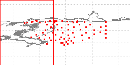
fileDescription: sample locations in study area
fileType: GIF
descriptiveKeywords: (MD_Keywords)
keyword: Unknown
keyword: ICSU-WDS > International Council for Science - World Data System
type: (MD_KeywordTypeCode) project
thesaurusName: (CI_Citation)
title: Global Change Master Directory (GCMD) Project Keywords
date: (CI_Date)
date: 2020-01-09
dateType: (CI_DateTypeCode) publication
edition: 9.1
citedResponsibleParty: (CI_ResponsibleParty)
organisationName: NASA Goddard Space Flight Center, Earth Science Data and Information System
contactInfo: (CI_Contact)
onlineResource: (CI_OnlineResource)
linkage: https://www.earthdata.nasa.gov/learn/find-data/idn/gcmd-keywords
name: Global Change Master Directory (GCMD) Keywords
description: The information provided on this page seeks to define how the GCMD Keywords are structured, used and accessed. It also provides information on how users can participate in the further development of the keywords.
function: (CI_OnLineFunctionCode) information
role: (CI_RoleCode) custodian
descriptiveKeywords: (MD_Keywords)
keyword: Scientific archives
keyword: Electronic records
keyword: Oceanography
keyword: Ocean bottom
keyword: Geology
keyword: Submarine geology
keyword: Marine sediments
type: (MD_KeywordTypeCode) theme
thesaurusName: (CI_Citation)
title: Library of Congress Subject Headings
date: (unknown)
citedResponsibleParty: (CI_ResponsibleParty)
organisationName: US Library of Congress
contactInfo: (CI_Contact)
onlineResource: (CI_OnlineResource)
linkage: http://id.loc.gov/authorities/subjects
protocol: http
applicationProfile: web browser
name: Library of Congress Subject Headings (LCSH)
description: The Library of Congress Subject Headings (LCSH) are part of a Linked Data Service, actively maintained since 1898 to catalog materials held at the Library of Congress.
function: (CI_OnLineFunctionCode) information
role: (CI_RoleCode) resourceProvider
descriptiveKeywords: (MD_Keywords)
keyword: Marine geology
type: (MD_KeywordTypeCode) theme
thesaurusName: (CI_Citation)
title: SeaDataNet Common Vocabularies
date: (unknown)
citedResponsibleParty: (CI_ResponsibleParty)
organisationName: SeaDataNet
contactInfo: (CI_Contact)
onlineResource: (CI_OnlineResource)
linkage: http://www.seadatanet.org/Standards-Software/Common-Vocabularies
protocol: http
applicationProfile: web browser
name: SeaDataNet Common Vocabularies
description: The SeaDataNet Vocabulary Server is populated with lists describing a wide range of entities relevant to marine metadata and data such as parameters, sea area names, platform classes, instrument types, and so on.
function: (CI_OnLineFunctionCode) information
role: (CI_RoleCode) resourceProvider
descriptiveKeywords: (MD_Keywords)
keyword: Sea-floor characteristics
type: (MD_KeywordTypeCode) theme
thesaurusName: (CI_Citation)
title: USGS Science Topics
date: (unknown)
citedResponsibleParty: (CI_ResponsibleParty)
organisationName: US Geological Survey
contactInfo: (CI_Contact)
onlineResource: (CI_OnlineResource)
linkage: https://www2.usgs.gov/science/about/
protocol: http
applicationProfile: web browser
name: USGS Thesaurus
description: The USGS Thesaurus contains thematic terms for categorizing information resources intended to support finding and understanding scientific information.
function: (CI_OnLineFunctionCode) information
role: (CI_RoleCode) resourceProvider
descriptiveKeywords: (MD_Keywords)
keyword: Earth Science > Oceans > Marine Sediments > Geotechnical Properties
keyword: Earth Science > Oceans > Marine Sediments > Sedimentation
keyword: Earth Science > Oceans > Marine Sediments > Sediment Composition
keyword: Earth Science > Oceans > Marine Sediments > Sedimentary Textures
keyword: Earth Science > Oceans > Marine Sediments
keyword: Earth Science > Biosphere > Aquatic Ecosystems > Benthic Habitat
keyword: Earth Science > Solid Earth > Rocks/Minerals/Crystals > Sediments
type: (MD_KeywordTypeCode) theme
thesaurusName: (CI_Citation)
title: Global Change Master Directory (GCMD) Science Keywords
date: (CI_Date)
date: 2020-01-09
dateType: (CI_DateTypeCode) publication
edition: 9.1
citedResponsibleParty: (CI_ResponsibleParty)
organisationName: NASA Goddard Space Flight Center, Earth Science Data and Information System
contactInfo: (CI_Contact)
onlineResource: (CI_OnlineResource)
linkage: https://www.earthdata.nasa.gov/learn/find-data/idn/gcmd-keywords
name: Global Change Master Directory (GCMD) Keywords
description: The information provided on this page seeks to define how the GCMD Keywords are structured, used and accessed. It also provides information on how users can participate in the further development of the keywords.
function: (CI_OnLineFunctionCode) information
role: (CI_RoleCode) custodian
descriptiveKeywords: (MD_Keywords)
keyword: In Situ Ocean-based Platforms > Ships
type: (MD_KeywordTypeCode) platform
thesaurusName: (CI_Citation)
title: Global Change Master Directory (GCMD) Platform Keywords
date: (CI_Date)
date: 2020-01-09
dateType: (CI_DateTypeCode) publication
edition: 9.1
citedResponsibleParty: (CI_ResponsibleParty)
organisationName: NASA Goddard Space Flight Center, Earth Science Data and Information System
contactInfo: (CI_Contact)
onlineResource: (CI_OnlineResource)
linkage: https://www.earthdata.nasa.gov/learn/find-data/idn/gcmd-keywords
name: Global Change Master Directory (GCMD) Keywords
description: The information provided on this page seeks to define how the GCMD Keywords are structured, used and accessed. It also provides information on how users can participate in the further development of the keywords.
function: (CI_OnLineFunctionCode) information
role: (CI_RoleCode) custodian
descriptiveKeywords: (MD_Keywords)
keyword: In Situ/Laboratory Instruments > Photon/Optical Detectors > Cameras
keyword: In Situ/Laboratory Instruments > Corers > Coring Devices
keyword: In Situ/Laboratory Instruments > Samplers > Dredging Devices
keyword: In Situ/Laboratory Instruments > Samplers > Grabbers/Traps/Collectors > Grab Samplers
type: (MD_KeywordTypeCode) instrument
thesaurusName: (CI_Citation)
title: Global Change Master Directory (GCMD) Instrument Keywords
date: (CI_Date)
date: 2020-01-09
dateType: (CI_DateTypeCode) publication
edition: 9.1
citedResponsibleParty: (CI_ResponsibleParty)
organisationName: NASA Goddard Space Flight Center, Earth Science Data and Information System
contactInfo: (CI_Contact)
onlineResource: (CI_OnlineResource)
linkage: https://www.earthdata.nasa.gov/learn/find-data/idn/gcmd-keywords
name: Global Change Master Directory (GCMD) Keywords
description: The information provided on this page seeks to define how the GCMD Keywords are structured, used and accessed. It also provides information on how users can participate in the further development of the keywords.
function: (CI_OnLineFunctionCode) information
role: (CI_RoleCode) custodian
descriptiveKeywords: (MD_Keywords)
keyword: DOC/NOAA/NESDIS/NCEI > National Centers for Environmental Information, NESDIS, NOAA, U.S. Department of Commerce
keyword: DOC/NOAA/NESDIS/NGDC > National Geophysical Data Center, NESDIS, NOAA, U.S. Department of Commerce
type: (MD_KeywordTypeCode) dataCenter
thesaurusName: (CI_Citation)
title: Global Change Master Directory (GCMD) Data Center Keywords
date: (CI_Date)
date: 2020-01-09
dateType: (CI_DateTypeCode) publication
edition: 9.1
citedResponsibleParty: (CI_ResponsibleParty)
organisationName: NASA Goddard Space Flight Center, Earth Science Data and Information System
contactInfo: (CI_Contact)
onlineResource: (CI_OnlineResource)
linkage: https://www.earthdata.nasa.gov/learn/find-data/idn/gcmd-keywords
name: Global Change Master Directory (GCMD) Keywords
description: The information provided on this page seeks to define how the GCMD Keywords are structured, used and accessed. It also provides information on how users can participate in the further development of the keywords.
function: (CI_OnLineFunctionCode) information
role: (CI_RoleCode) custodian
descriptiveKeywords: (MD_Keywords)
keyword: Ocean > Atlantic Ocean > NORTH ATLANTIC OCEAN > GULF OF MEXICO
keyword: Vertical Location >Sea Floor
type: (MD_KeywordTypeCode) place
thesaurusName: (CI_Citation)
title: Global Change Master Directory (GCMD) Location Keywords
date: (CI_Date)
date: 2020-01-09
dateType: (CI_DateTypeCode) publication
edition: 9.1
citedResponsibleParty: (CI_ResponsibleParty)
organisationName: NASA Goddard Space Flight Center, Earth Science Data and Information System
contactInfo: (CI_Contact)
onlineResource: (CI_OnlineResource)
linkage: https://www.earthdata.nasa.gov/learn/find-data/idn/gcmd-keywords
name: Global Change Master Directory (GCMD) Keywords
description: The information provided on this page seeks to define how the GCMD Keywords are structured, used and accessed. It also provides information on how users can participate in the further development of the keywords.
function: (CI_OnLineFunctionCode) information
role: (CI_RoleCode) custodian
resourceConstraints: (MD_LegalConstraints)
accessConstraints: (MD_RestrictionCode) otherRestrictions
otherConstraints: Distribution liability: NOAA and NCEI make no warranty, expressed or implied, regarding these data, nor does the fact of distribution constitute such a warranty. NOAA and NCEI cannot assume liability for any damages caused by any errors or omissions in these data. If appropriate, NCEI can only certify that the data it distributes are an authentic copy of the records that were accepted for inclusion in the NCEI archives.
resourceConstraints: (MD_LegalConstraints)
useConstraints: (MD_RestrictionCode) otherRestrictions
otherConstraints: Use liability: NOAA and NCEI cannot provide any warranty as to the accuracy, reliability, or completeness of furnished data. Users assume responsibility to determine the usability of these data. The user is responsible for the results of any application of this data for other than its intended purpose.
resourceConstraints: (MD_LegalConstraints)
useLimitation: (MD_RestrictionCode) otherRestrictions
otherConstraints: Cite as: Sawyer, William B., Chad Vaughan, Dawn Lavoie, Yoko Furukawa, Nancy Carnaggio, Jennifer Maclean, and Edward Populis. 2001. Northern Gulf Littoral Initiative (NGLI), Geology and Physical Properties of Marine Sediments in the N.E. Gulf of Mexico: Data Report. Report NRL/MR-MM/7430--01-8548, U.S. Naval Research Laboratory, Washington, DC, 12 pages., and cite NCEI as the source of the data.
resourceConstraints: (MD_Constraints)
useLimitation: Produced by the NOAA National Centers for Environmental Information. Not subject to copyright protection within the United States.
resourceConstraints: (MD_LegalConstraints)
useConstraints: (MD_RestrictionCode) otherRestrictions
otherConstraints: While every effort has been made to ensure that these data are accurate and reliable within the limits of the current state of the art, NOAA cannot assume liability for any damages caused by any errors or omissions in the data, nor as a result of the failure of the data to function on a particular system. NOAA makes no warranty, expressed or implied, nor does the fact of distribution constitute such a warranty.
resourceConstraints: (MD_SecurityConstraints)
classification: (MD_ClassificationCode) unclassified
resourceConstraints: (MD_LegalConstraints)
accessConstraints: (MD_RestrictionCode) otherRestrictions
otherConstraints: Access to this dataset is unrestricted.
aggregationInfo: (MD_AggregateInformation)
aggregateDataSetName: (CI_Citation)
title: Northern Gulf Littoral Initiative (NGLI), Geology and Physical Properties of Marine Sediments in the N.E. Gulf of Mexico: Data Report
date: (CI_Date)
date: 2001-12-31
dateType: (CI_DateTypeCode) publication
citedResponsibleParty: (CI_ResponsibleParty)
organisationName: U.S. Naval Research Laboratory
role: (CI_RoleCode) author
citedResponsibleParty: (CI_ResponsibleParty)
organisationName: (inapplicable)
contactInfo: (CI_Contact)
onlineResource: (CI_OnlineResource)
linkage: https://apps.dtic.mil/sti/pdfs/ADA393657.pdf
protocol: WWW:LINK-1.0-http--link
applicationProfile: Web Browser
name: Report NRL/MR-MM/7430--01-8548
function: (CI_OnLineFunctionCode) information
role: (inapplicable)
otherCitationDetails: Sawyer, William B., Chad Vaughan, Dawn Lavoie, Yoko Furukawa, Nancy Carnaggio, Jennifer Maclean, and Edward Populis, 2001, Northern Gulf Littoral Initiative (NGLI), Geology and Physical Properties of Marine Sediments in the N.E. Gulf of Mexico: Data Report. Report NRL/MR-MM/7430--01-8548, U.S. Naval Research Laboratory, Washington, DC, 12 pages.
associationType: (DS_AssociationTypeCode) crossReference
initiativeType: (DS_InitiativeTypeCode) project
aggregationInfo: (MD_AggregateInformation)
aggregateDataSetName: (CI_Citation)
title: The NGDC Seafloor Sediment Grain Size Database
date: (CI_Date)
date: 1976-12-31
dateType: (CI_DateTypeCode) publication
identifier: (MD_Identifier)
code:
Anchor: DOI doi:10.7289/V5G44N6W
citedResponsibleParty: (CI_ResponsibleParty)
organisationName: National Geophysical Data Center, NOAA
role: (CI_RoleCode) author
citedResponsibleParty: (CI_ResponsibleParty)
organisationName: (inapplicable)
contactInfo: (CI_Contact)
onlineResource: (CI_OnlineResource)
linkage: https://doi.org/10.7289/V5G44N6W
protocol: WWW:LINK-1.0-http--link
applicationProfile: Web Browser
name: Related database (doi:10.7289/V5G44N6W)
description: This database contains related grain size data.
function: (CI_OnLineFunctionCode) information
role: (inapplicable)
otherCitationDetails: National Geophysical Data Center (1976): The NGDC Seafloor Sediment Grain Size Database. NOAA National Centers for Environmental Information. doi:10.7289/V5G44N6W
associationType: (DS_AssociationTypeCode) crossReference
initiativeType: (DS_InitiativeTypeCode) project
aggregationInfo: (MD_AggregateInformation)
aggregateDataSetName: (CI_Citation)
title: NCEI Marine Geology Data Archive
date: (CI_Date)
date: 1977-12-31
dateType: (CI_DateTypeCode)
citedResponsibleParty: (CI_ResponsibleParty)
organisationName: NOAA National Centers for Environmental Information
role: (CI_RoleCode) resourceProvider
citedResponsibleParty: (CI_ResponsibleParty)
organisationName: (inapplicable)
contactInfo: (CI_Contact)
onlineResource: (CI_OnlineResource)
linkage: https://data.noaa.gov/metaview/page?xml=NOAA/NESDIS/NGDC/Collection/iso/xml/Marine_Geology.xml&view=getDataView&header=none
protocol: WWW:LINK-1.0-http--link
applicationProfile: Web Browser
name: Parent Archive
description: Information about the Marine Geology Data Archive at NCEI.
function: (CI_OnLineFunctionCode) information
role: (inapplicable)
associationType: (DS_AssociationTypeCode) largerWorkCitation
initiativeType: (DS_InitiativeTypeCode) collection
aggregationInfo: (MD_AggregateInformation)
aggregateDataSetName: (CI_Citation)
title: NOAA/NCEI Marine Geology WAF
date: (CI_Date)
date: 2015-10-05
dateType: (CI_DateTypeCode)
citedResponsibleParty: (CI_ResponsibleParty)
organisationName: NOAA National Centers for Environmental Information
role: (CI_RoleCode) author
citedResponsibleParty: (CI_ResponsibleParty)
organisationName: (inapplicable)
contactInfo: (CI_Contact)
onlineResource: (CI_OnlineResource)
linkage: https://data.noaa.gov/waf/NOAA/NESDIS/NGDC/MGG/Geology/iso/
protocol: WWW:LINK-1.0-http--link
applicationProfile: Web Browser
name: Marine geology metadata records.
function: (CI_OnLineFunctionCode) search
role: (inapplicable)
associationType: (DS_AssociationTypeCode) crossReference
initiativeType: (DS_InitiativeTypeCode) collection
spatialRepresentationType: (MD_SpatialRepresentationTypeCode) vector
spatialResolution: (missing) (MD_Resolution)
levelOfDetail: Vertical resolution is 1 meter and horizontal resolution is .001 degree.
language:
LanguageCode: eng; USA
characterSet: (MD_CharacterSetCode) UTF8
topicCategory: (MD_TopicCategoryCode) geoscientificInformation
topicCategory: (MD_TopicCategoryCode) oceans
environmentDescription: Native Dataset Environment: ASCII text
extent: (EX_Extent)
description: Northern Gulf of Mexico
geographicElement: (EX_GeographicBoundingBox)
westBoundLongitude: -89.474
eastBoundLongitude: -87.75
southBoundLatitude: 29.0256
northBoundLatitude: 30.284
temporalElement: (EX_TemporalExtent)
extent:
TimePeriod:
description: Publication Date
beginPosition: 20010101
endPosition: 20011231
verticalElement: (EX_VerticalExtent)
minimumValue:
Real: -1338
maximumValue:
Real: -3
verticalCRS: (missing)
supplementalInformation: Data from this report are available online from NCEI, on CD-ROM from the Naval Research Laboratory, and also online from the U.S. Naval Research Laboratory (http://www7430.nrlssc.navy.mil/facilities/coresedlab/NGLI.htm) as NRL Multi-Media Report NRL/MR-MM/7430--01-8548.
return to top
contentInfo: (MD_CoverageDescription)
attributeDescription:
RecordType: The Latitude and Longitude (point) from which a sample of sediment or rock was collected from the sea floor or a lakebed.
contentType: (MD_CoverageContentTypeCode) point
dimension: (MD_Band)
sequenceIdentifier:
MemberName:
aName: Latitude
attributeType: (unknown)
descriptor: Distance measured north or south from the equator. Distance north is positive, distance south is negative.
maxValue:
Real: 90.00000
minValue:
Real: -90.00000
units:
UnitDefinition:
identifier: decimal degrees
name: decimal degrees
dimension: (MD_Band)
sequenceIdentifier:
MemberName:
aName: Longitude
attributeType: (unknown)
descriptor: Longitude is measured from the Prime Meridian (which is the north/south line that runs through Greenwich, England), values measured east are positive and values measured west are negative.
maxValue:
Real: 180.00000
minValue:
Real: -180.00000
units:
UnitDefinition:
identifier: decimal degrees
name: decimal degrees
return to top
contentInfo: (MD_FeatureCatalogueDescription)
complianceCode: false
includedWithDataset: true
featureTypes:
LocalName:
featureCatalogueCitation: (CI_Citation)
title: Documentation for the Northern Gulf Littoral Initiative (NGLI), Geology and Physical Properties of Marine Sediments in the N.E. Gulf of Mexico: Data Report dataset.
date: (CI_Date)
date: 2001-12-31
dateType: (CI_DateTypeCode) creation
otherCitationDetails: Entities and attributes are completely described in a text file accompanying the dataset on download.
return to top
distributionInfo: (MD_Distribution)
distributor: (MD_Distributor)
distributorContact: (CI_ResponsibleParty)
organisationName: NOAA National Centers for Environmental Information
contactInfo: (CI_Contact)
address: (CI_Address)
electronicMailAddress: ncei.info@noaa.gov
onlineResource: (CI_OnlineResource)
linkage: https://www.ncei.noaa.gov/contact
name: NCEI Contact Information
description: Information for contacts at NCEI.
function: (CI_OnLineFunctionCode) information
role: (CI_RoleCode) distributor
distributionOrderProcess: (MD_StandardOrderProcess)
fees: In most cases, electronic downloads of the data are free. However, fees may apply for custom orders, data certifications, copies of analog materials, and data distribution on physical media.
orderingInstructions: Contact NCEI for other distribution options and instructions.
distributorFormat: (MD_Format)
name: XLS
version: (unknown)
distributorFormat: (MD_Format)
name: GRD
version: (unknown)
distributorFormat: (MD_Format)
name: GIF
version: (unknown)
distributorFormat: (MD_Format)
name: JPEG
version: (unknown)
distributorFormat: (MD_Format)
name: PNG
version: (unknown)
distributorFormat: (MD_Format)
name: PDF
version: (unknown)
distributorTransferOptions: (MD_DigitalTransferOptions)
onLine: (CI_OnlineResource)
linkage: https://data.noaa.gov/metaview/page?xml=NOAA/NESDIS/NGDC/MGG/Geology/iso/xml/G02123.xml&view=getDataView&header=none
protocol: WWW:LINK-1.0-http--link
applicationProfile: Web Browser
name: Metadata Landing Page
description: Information about the data set, all access options, and complete documentation.
function: (CI_OnLineFunctionCode) information
distributorTransferOptions: (MD_DigitalTransferOptions)
onLine: (CI_OnlineResource)
linkage: https://www.ngdc.noaa.gov/mgg/geology/data/g02123/
protocol: WWW:LINK-1.0-http--link
applicationProfile: Web Browser
name: Data files and documentation
description: Access to originator's data files and documentation.
function: (CI_OnLineFunctionCode) download
return to top
dataQualityInfo: (DQ_DataQuality)
scope: (DQ_Scope)
level: (MD_ScopeCode) dataset
extent: #boundingExtent
levelDescription: (MD_ScopeDescription)
dataset: gov.noaa.ngdc.mgg.geology:G02123
report: (DQ_AbsoluteExternalPositionalAccuracy)
nameOfMeasure: Horizontal Positional Accuracy
measureDescription: (unknown)
evaluationMethodDescription: The horizontal accuracy of data values is approximately .001 degree of latitude/longitude.
result: (unknown)
report: (DQ_QuantitativeAttributeAccuracy)
nameOfMeasure: Reliability
measureDescription: (unknown)
evaluationMethodDescription: Quality control was performed by the originator. NGDC performed basic out-of-range location testing.
result: (unknown)
lineage: (LI_Lineage)
statement: lineage prior to transfer to NCEI is unknown
processStep: (LI_ProcessStep)
description: Received data from originator
dateTime:
DateTime: 2001-01-01T00:00:00
source: (LI_Source)
description: William B. Sawyer, Chad Vaughan, Dawn Lavoie, Yoko Furukawa, Nancy Carnaggio, Jennifer Maclean, Eddie Populis U.S. Naval Research Laboratory (NRL)
return to top
dataQualityInfo: (DQ_DataQuality)
scope: (DQ_Scope)
level: (MD_ScopeCode) repository
levelDescription: (MD_ScopeDescription)
other: NOAA National Centers for Environmental Information
lineage: (LI_Lineage)
processStep: (LE_ProcessStep)
description: NOAA created the National Centers for Environmental Information (NCEI) by merging NOAA's National Climatic Data Center (NCDC), National Geophysical Data Center (NGDC), and National Oceanographic Data Center (NODC), including the National Coastal Data Development Center (NCDDC), per the Consolidated and Further Continuing Appropriations Act, 2015, Public Law 113-235. NCEI launched publicly on April 22, 2015.
dateTime:
DateTime: 2015-04-22T00:00:00
return to top
metadataMaintenance: (MD_MaintenanceInformation)
maintenanceAndUpdateFrequency: (MD_MaintenanceFrequencyCode) asNeeded
maintenanceNote: Modified for compliance to NCEI Template v1.2.
return to top
acquisitionInformation: (MI_AcquisitionInformation)
instrument: (MI_Instrument)
identifier: (MD_Identifier)
code: In Situ/Laboratory Instruments
type: instrument
description: Instrument Type: Sea floor and lakebed geologic sampling (coring, drilling, dredging, trawling, and/or grab sampling devices) and/or in situ measurements (cameras, visual observations, and/or recorders/loggers)
platform: (MI_Platform)
identifier: (RS_Identifier)
code: Pelican
description: (unknown)
instrument: (MI_Instrument)
identifier: (MD_Identifier)
code: In Situ/Laboratory Instruments
type: instrument
description: Instrument Type: Sea floor and lakebed geologic sampling (coring, drilling, dredging, trawling, and/or grab sampling devices) and/or in situ measurements (cameras, visual observations, and/or recorders/loggers)