Advanced CORK (ACORK) Data from the Nankai Trough, Ocean Drilling Program (ODP) Holes 808I and 1173B
- spatialRepresentationInfo
- referenceSystemInfo
- identificationInfo
- contentInfo
- distributionInfo
- dataQualityInfo
- dataQualityInfo
- metadataMaintenance
- acquisitionInformation
(MI_Metadata)
fileIdentifier: gov.noaa.ngdc.mgg.geology:G13001
hierarchyLevel: (MD_ScopeCode) dataset
contact: (CI_ResponsibleParty)
organisationName: NOAA National Centers for Environmental Information
contactInfo: (CI_Contact)
address: (CI_Address)
electronicMailAddress: ncei.info@noaa.gov
onlineResource: (CI_OnlineResource)
linkage: https://www.ncei.noaa.gov/contact
name: NCEI Contact Information
description: Information for contacts at NCEI.
function: (CI_OnLineFunctionCode) information
role: (CI_RoleCode) pointOfContact
dateStamp: 2020-04-21
metadataStandardName: ISOO 19115-2 Geographic Information - Metadata - Part 2: Extensions for Imagery and Gridded Data
metadataStandardVersion: ISO 19115-2:2009(E)
return to top
spatialRepresentationInfo: (MD_VectorSpatialRepresentation)
geometricObjects: (MD_GeometricObjects)
geometricObjectType: (MD_GeometricObjectTypeCode) point
return to top
referenceSystemInfo: (MD_ReferenceSystem)
referenceSystemIdentifier: (RS_Identifier)
authority: (CI_Citation)
title: European Petroleum Survey Group (EPSG) Geodetic Parameter Registry
date: (CI_Date)
date: 2008-11-12
dateType: (CI_DateTypeCode) publication
citedResponsibleParty: (CI_ResponsibleParty)
organisationName: European Petroleum Survey Group
contactInfo: (CI_Contact)
onlineResource: (CI_OnlineResource)
linkage: http://www.epsg-registry.org/
name: European Petroleum Survey Group Geodetic Parameter Dataset
description: Registry that accesses the EPSG Geodetic Parameter Dataset, which is a structured dataset of Coordinate Reference Systems and Coordinate Transformations.
function: (CI_OnLineFunctionCode) search
role: (inapplicable)
code: urn:ogc:def:crs:EPSG:4326
version: 6.18.3
return to top
identificationInfo: (MD_DataIdentification)
citation: (CI_Citation)
title: Advanced CORK (ACORK) Data from the Nankai Trough, Ocean Drilling Program (ODP) Holes 808I and 1173B
date: (CI_Date)
date: 2013-11-18
dateType: (CI_DateTypeCode) publication
date: (CI_Date)
date: 2014-11-18
dateType: (CI_DateTypeCode) revision
identifier: (MD_Identifier)
authority: (CI_Citation)
title: International DOI Foundation (IDF)
date: (inapplicable)
code:
Anchor: DOI doi:10.7289/V5KW5CXW
identifier: (MD_Identifier)
authority: (CI_Citation)
title: NOAA National Centers for Environmental Information
date: (inapplicable)
code: NCEI Metadata ID: gov.noaa.ngdc.mgg.geology:G13001
citedResponsibleParty: (CI_ResponsibleParty)
individualName: Becker, Keir
organisationName: University of Miami, RSMAS
role: (CI_RoleCode) author
citedResponsibleParty: (CI_ResponsibleParty)
individualName: Davis, Earl
organisationName: Geological Survey of Canada
role: (CI_RoleCode) author
citedResponsibleParty: (CI_ResponsibleParty)
organisationName: NOAA National Centers for Environmental Information
role: (CI_RoleCode) publisher
presentationForm: (CI_PresentationFormCode) tableDigital
series: (CI_Series)
name: Proceedings of the Ocean Drilling Program, Initial Reports
issueIdentification: Leg 196
otherCitationDetails: Mikada, H., Becker, K., Moore, J.C., Klaus, A., et al., 2002. Proc. ODP, Init. Repts., 196: College Station, TX (Ocean Drilling Program). doi:10.2973/odp.proc.ir.196.2002
abstract: The ASCII datasets contain pressure values measured at 10-min intervals at the seafloor and several subseafloor depths in two "Advanced CORK" hydrologic observatories installed by ODP in 2001 at Sites 808I and 1173B in the Nankai Trough subduction zone. The datasets were downloaded from logger memory using Japanese research submersibles at irregular intervals of 1-2 years. Currently there are 14 total datasets as follows: downloads at 808I in 2002, 2003, 2004, 2006, 2007, 2008, 2011, and 2012; downloads at 1173B in 2002, 2004, 2006, 2007, 2011, and 2012. They should be of interest to scientists studying seismogenic processes at subduction zones. Please note that much of the data from 808I may be compromised by the lack of seal for the central bore. In addition, several of the valves on both installations were bumped open by a reentry camera frame during deployment, so the first year's installment of data from both sites was compromised until the valves were closed during the 2002 Kaiko operations. There are separate data files for each of the downloads. Each data file has a header of basic metadata that describes the contents of the columns and the respective checks on logger clock drift. Typically, the clock drift was checked just before each download, and the clocks were then reset to UTC immediately after the respective downloads. In three cases, the records of the logger times checks have been misplaced and the drifts computed from other clock checks (consistent from year to year at each site, order 1-2 minutes per year) are reported. Note that the times in the data files have not been corrected for the clock drift. Also, during some of the download operations, there were attempts to calibrate the relative offsets among gauges by opening the seafloor valves to apply seafloor pressure to all the gauges. These are not reflected in the main data files. The installations have battery power for 10-15 years of operation, longer with planned addition of supplemental batteries, so there should be future downloads to add to the archive. There are likely to be future JAMSTEC download opportunities at unpredictable intervals, hopefully every 1-2 years. At approximately 5 Mb/yr, future datasets should be approximately 5-10 Mb in size.
purpose: scientific research
credit: If you utilize the Nankai ACORK data from this site in any publications, please acknowledge support from the Ocean Drilling Program (ODP), Geological Survey of Canada, and the National Science Foundation (NSF grants OCE-0083156 and OCE-0825210), as well as JAMSTEC for submersible support for the data downloads in 2002, 2003, 2004, 2006-2008, 2011, and 2012.
status: (MD_ProgressCode) onGoing
status: (MD_ProgressCode) historicalArchive
pointOfContact: (CI_ResponsibleParty)
organisationName: NOAA National Centers for Environmental Information
contactInfo: (CI_Contact)
address: (CI_Address)
electronicMailAddress: ncei.info@noaa.gov
onlineResource: (CI_OnlineResource)
linkage: https://www.ncei.noaa.gov/contact
name: NCEI Contact Information
description: Information for contacts at NCEI.
function: (CI_OnLineFunctionCode) information
role: (CI_RoleCode) pointOfContact
pointOfContact: (CI_ResponsibleParty)
organisationName: NOAA National Centers for Environmental Information
positionName: Marine Geology Data Manager
contactInfo: (CI_Contact)
address: (CI_Address)
deliveryPoint: 325 Broadway, Mail Code E/NE42
city: Boulder
administrativeArea: CO
postalCode: 80305-3328
country: USA
electronicMailAddress: geology.info@noaa.gov
role: (CI_RoleCode) pointOfContact
resourceMaintenance: (MD_MaintenanceInformation)
maintenanceAndUpdateFrequency: (MD_MaintenanceFrequencyCode) irregular
maintenanceNote: The installations have battery power for 10-15 years of operation, longer with planned addition of supplemental batteries, so there should be future downloads to add to the archive. There are likely to be future JAMSTEC download opportunities at unpredictable intervals, hopefully every 1-2 years.
graphicOverview: (MD_BrowseGraphic)
fileName: https://www.ngdc.noaa.gov/mgg/image/acorklocation.jpg
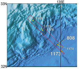
fileDescription: ACORK location map
fileType: JPEG
descriptiveKeywords: (MD_Keywords)
keyword: ODP
keyword: ICSU-WDS > International Council for Science - World Data System
type: (MD_KeywordTypeCode) project
thesaurusName: (CI_Citation)
title: Global Change Master Directory (GCMD) Project Keywords
date: (CI_Date)
date: 2020-01-09
dateType: (CI_DateTypeCode) publication
edition: 9.1
citedResponsibleParty: (CI_ResponsibleParty)
organisationName: NASA Goddard Space Flight Center, Earth Science Data and Information System
contactInfo: (CI_Contact)
onlineResource: (CI_OnlineResource)
linkage: https://www.earthdata.nasa.gov/learn/find-data/idn/gcmd-keywords
name: Global Change Master Directory (GCMD) Keywords
description: The information provided on this page seeks to define how the GCMD Keywords are structured, used and accessed. It also provides information on how users can participate in the further development of the keywords.
function: (CI_OnLineFunctionCode) information
role: (CI_RoleCode) custodian
descriptiveKeywords: (MD_Keywords)
keyword: Scientific archives
keyword: Electronic records
keyword: Oceanography
keyword: Ocean bottom
keyword: Geology
keyword: Submarine geology
type: (MD_KeywordTypeCode) theme
thesaurusName: (CI_Citation)
title: Library of Congress Subject Headings
date: (unknown)
citedResponsibleParty: (CI_ResponsibleParty)
organisationName: US Library of Congress
contactInfo: (CI_Contact)
onlineResource: (CI_OnlineResource)
linkage: http://id.loc.gov/authorities/subjects
protocol: http
applicationProfile: web browser
name: Library of Congress Subject Headings (LCSH)
description: The Library of Congress Subject Headings (LCSH) are part of a Linked Data Service, actively maintained since 1898 to catalog materials held at the Library of Congress.
function: (CI_OnLineFunctionCode) information
role: (CI_RoleCode) resourceProvider
descriptiveKeywords: (MD_Keywords)
keyword: Marine geology
type: (MD_KeywordTypeCode) theme
thesaurusName: (CI_Citation)
title: SeaDataNet Common Vocabularies
date: (unknown)
citedResponsibleParty: (CI_ResponsibleParty)
organisationName: SeaDataNet
contactInfo: (CI_Contact)
onlineResource: (CI_OnlineResource)
linkage: http://www.seadatanet.org/Standards-Software/Common-Vocabularies
protocol: http
applicationProfile: web browser
name: SeaDataNet Common Vocabularies
description: The SeaDataNet Vocabulary Server is populated with lists describing a wide range of entities relevant to marine metadata and data such as parameters, sea area names, platform classes, instrument types, and so on.
function: (CI_OnLineFunctionCode) information
role: (CI_RoleCode) resourceProvider
descriptiveKeywords: (MD_Keywords)
keyword: Sea-floor characteristics
type: (MD_KeywordTypeCode) theme
thesaurusName: (CI_Citation)
title: USGS Science Topics
date: (unknown)
citedResponsibleParty: (CI_ResponsibleParty)
organisationName: US Geological Survey
contactInfo: (CI_Contact)
onlineResource: (CI_OnlineResource)
linkage: https://www2.usgs.gov/science/about/
protocol: http
applicationProfile: web browser
name: USGS Thesaurus
description: The USGS Thesaurus contains thematic terms for categorizing information resources intended to support finding and understanding scientific information.
function: (CI_OnLineFunctionCode) information
role: (CI_RoleCode) resourceProvider
descriptiveKeywords: (MD_Keywords)
keyword: Earth Science > Oceans > Ocean Pressure
type: (MD_KeywordTypeCode) theme
thesaurusName: (CI_Citation)
title: Global Change Master Directory (GCMD) Science Keywords
date: (CI_Date)
date: 2020-01-09
dateType: (CI_DateTypeCode) publication
edition: 9.1
citedResponsibleParty: (CI_ResponsibleParty)
organisationName: NASA Goddard Space Flight Center, Earth Science Data and Information System
contactInfo: (CI_Contact)
onlineResource: (CI_OnlineResource)
linkage: https://www.earthdata.nasa.gov/learn/find-data/idn/gcmd-keywords
name: Global Change Master Directory (GCMD) Keywords
description: The information provided on this page seeks to define how the GCMD Keywords are structured, used and accessed. It also provides information on how users can participate in the further development of the keywords.
function: (CI_OnLineFunctionCode) information
role: (CI_RoleCode) custodian
descriptiveKeywords: (MD_Keywords)
keyword: In Situ Ocean-based Platforms > Ships
type: (MD_KeywordTypeCode) platform
thesaurusName: (CI_Citation)
title: Global Change Master Directory (GCMD) Platform Keywords
date: (CI_Date)
date: 2020-01-09
dateType: (CI_DateTypeCode) publication
edition: 9.1
citedResponsibleParty: (CI_ResponsibleParty)
organisationName: NASA Goddard Space Flight Center, Earth Science Data and Information System
contactInfo: (CI_Contact)
onlineResource: (CI_OnlineResource)
linkage: https://www.earthdata.nasa.gov/learn/find-data/idn/gcmd-keywords
name: Global Change Master Directory (GCMD) Keywords
description: The information provided on this page seeks to define how the GCMD Keywords are structured, used and accessed. It also provides information on how users can participate in the further development of the keywords.
function: (CI_OnLineFunctionCode) information
role: (CI_RoleCode) custodian
descriptiveKeywords: (MD_Keywords)
keyword: In Situ/Laboratory Instruments > Gauges > BOTTOM PRESSURE GAUGES
type: (MD_KeywordTypeCode) instrument
thesaurusName: (CI_Citation)
title: Global Change Master Directory (GCMD) Instrument Keywords
date: (CI_Date)
date: 2020-01-09
dateType: (CI_DateTypeCode) publication
edition: 9.1
citedResponsibleParty: (CI_ResponsibleParty)
organisationName: NASA Goddard Space Flight Center, Earth Science Data and Information System
contactInfo: (CI_Contact)
onlineResource: (CI_OnlineResource)
linkage: https://www.earthdata.nasa.gov/learn/find-data/idn/gcmd-keywords
name: Global Change Master Directory (GCMD) Keywords
description: The information provided on this page seeks to define how the GCMD Keywords are structured, used and accessed. It also provides information on how users can participate in the further development of the keywords.
function: (CI_OnLineFunctionCode) information
role: (CI_RoleCode) custodian
descriptiveKeywords: (MD_Keywords)
keyword: DOC/NOAA/NESDIS/NCEI > National Centers for Environmental Information, NESDIS, NOAA, U.S. Department of Commerce
keyword: DOC/NOAA/NESDIS/NGDC > National Geophysical Data Center, NESDIS, NOAA, U.S. Department of Commerce
type: (MD_KeywordTypeCode) dataCenter
thesaurusName: (CI_Citation)
title: Global Change Master Directory (GCMD) Data Center Keywords
date: (CI_Date)
date: 2020-01-09
dateType: (CI_DateTypeCode) publication
edition: 9.1
citedResponsibleParty: (CI_ResponsibleParty)
organisationName: NASA Goddard Space Flight Center, Earth Science Data and Information System
contactInfo: (CI_Contact)
onlineResource: (CI_OnlineResource)
linkage: https://www.earthdata.nasa.gov/learn/find-data/idn/gcmd-keywords
name: Global Change Master Directory (GCMD) Keywords
description: The information provided on this page seeks to define how the GCMD Keywords are structured, used and accessed. It also provides information on how users can participate in the further development of the keywords.
function: (CI_OnLineFunctionCode) information
role: (CI_RoleCode) custodian
descriptiveKeywords: (MD_Keywords)
keyword: Ocean > Pacific Ocean
type: (MD_KeywordTypeCode) place
thesaurusName: (CI_Citation)
title: Global Change Master Directory (GCMD) Location Keywords
date: (CI_Date)
date: 2020-01-09
dateType: (CI_DateTypeCode) publication
edition: 9.1
citedResponsibleParty: (CI_ResponsibleParty)
organisationName: NASA Goddard Space Flight Center, Earth Science Data and Information System
contactInfo: (CI_Contact)
onlineResource: (CI_OnlineResource)
linkage: https://www.earthdata.nasa.gov/learn/find-data/idn/gcmd-keywords
name: Global Change Master Directory (GCMD) Keywords
description: The information provided on this page seeks to define how the GCMD Keywords are structured, used and accessed. It also provides information on how users can participate in the further development of the keywords.
function: (CI_OnLineFunctionCode) information
role: (CI_RoleCode) custodian
resourceConstraints: (MD_LegalConstraints)
accessConstraints: (MD_RestrictionCode) otherRestrictions
otherConstraints: Distribution liability: NOAA and NCEI make no warranty, expressed or implied, regarding these data, nor does the fact of distribution constitute such a warranty. NOAA and NCEI cannot assume liability for any damages caused by any errors or omissions in these data. If appropriate, NCEI can only certify that the data it distributes are an authentic copy of the records that were accepted for inclusion in the NCEI archives.
resourceConstraints: (MD_LegalConstraints)
useConstraints: (MD_RestrictionCode) otherRestrictions
otherConstraints: Use liability: NOAA and NCEI cannot provide any warranty as to the accuracy, reliability, or completeness of furnished data. Users assume responsibility to determine the usability of these data. The user is responsible for the results of any application of this data for other than its intended purpose.
resourceConstraints: (MD_LegalConstraints)
useLimitation: (MD_RestrictionCode) otherRestrictions
otherConstraints: Cite as: Becker, K.; Davis, E.; et al. (2013): Advanced CORK (ACORK) Data from the Nankai Trough, Ocean Drilling Program (ODP) Holes 808I and 1173B. NOAA National Centers for Environmental Information. doi:10.7289/V5KW5CXW [access date]
resourceConstraints: (MD_LegalConstraints)
useLimitation: (MD_RestrictionCode) otherRestrictions
otherConstraints: Cite as: {{Author(s)}}. {{Publication year}}: {{Title}}. {{Version}}. [indicate subset used]. NOAA National Centers for Environmental Information. https://doi.org/{{DOI}}. Accessed [date].
resourceConstraints: (MD_LegalConstraints)
accessConstraints: (MD_RestrictionCode) otherRestrictions
otherConstraints: Access to this dataset is unrestricted.
resourceConstraints: (MD_Constraints)
useLimitation: If you utilize the Nankai ACORK data from this site in any publications, please acknowledge support from the Ocean Drilling Program (ODP), Geological Survey of Canada, and the National Science Foundation (NSF grants OCE-0083156 and OCE-0825210), as well as JAMSTEC for submersible support for the data downloads in 2002, 2003, 2004, 2006-2008, 2011, and 2012 (Note that the ACORK in Hole 1173B was not visited for data downloads in 2003 or 2008).
resourceConstraints: (MD_Constraints)
useLimitation: Produced by the NOAA National Centers for Environmental Information. Not subject to copyright protection within the United States.
resourceConstraints: (MD_SecurityConstraints)
classification: (MD_ClassificationCode) unclassified
aggregationInfo: (MD_AggregateInformation)
aggregateDataSetName: (CI_Citation)
title: Volume 196 Initial Reports
date: (CI_Date)
date: 2002-12-31
dateType: (CI_DateTypeCode) publication
identifier: (MD_Identifier)
code:
Anchor: DOI doi:10.2973/odp.proc.ir.196.2002
citedResponsibleParty: (CI_ResponsibleParty)
organisationName: (inapplicable)
contactInfo: (CI_Contact)
onlineResource: (CI_OnlineResource)
linkage: https://doi.org/doi:10.2973/odp.proc.ir.196.2002
protocol: WWW:LINK-1.0-http--link
applicationProfile: Web Browser
name: doi:10.2973/odp.proc.ir.196.2002
description: Related scientific study
function: (CI_OnLineFunctionCode) information
role: (inapplicable)
citedResponsibleParty: (CI_ResponsibleParty)
individualName: H. Mikada
role: (CI_RoleCode) author
citedResponsibleParty: (CI_ResponsibleParty)
individualName: Keir Becker
organisationName: University of Miami, RSMAS
role: (CI_RoleCode) author
citedResponsibleParty: (CI_ResponsibleParty)
individualName: J.C. Moore
role: (CI_RoleCode) author
citedResponsibleParty: (CI_ResponsibleParty)
individualName: Adam Klaus
organisationName: Ocean Drilling Program (ODP)
role: (CI_RoleCode) author
citedResponsibleParty: (CI_ResponsibleParty)
organisationName: Ocean Drilling Program (ODP)
role: (CI_RoleCode) publisher
presentationForm: (CI_PresentationFormCode) documentHardcopy
series: (CI_Series)
name: Initial Reports of the Ocean Drilling Program
issueIdentification: Volume 196 Initial Reports, 30 April 2002, ISSN 1096-2158, doi:10.2973/odp.proc.ir.196.2002
otherCitationDetails: Mikada, H., Becker, K., Moore, J.C., Klaus, A., et al., 2002. Deformation and Fluid Flow Processes in the Nankai Trough Accretionary Prism: Logging While Drilling and Advanced CORKs, Proc. ODP, Init. Repts., 196: College Station, TX (Ocean Drilling Program). doi:10.2973/odp.proc.ir.196.2002
associationType: (DS_AssociationTypeCode) crossReference
initiativeType: (DS_InitiativeTypeCode) study
aggregationInfo: (MD_AggregateInformation)
aggregateDataSetName: (CI_Citation)
title: Archive of Core and Site/Hole Data and Photographs from the Ocean Drilling Program (ODP)
date: (CI_Date)
date: 2005-12-31
dateType: (CI_DateTypeCode) publication
identifier: (MD_Identifier)
code:
Anchor: DOI doi:10.7289/V5W37T8C
citedResponsibleParty: (CI_ResponsibleParty)
organisationName: Ocean Drilling Program
role: (CI_RoleCode) author
citedResponsibleParty: (CI_ResponsibleParty)
organisationName: (inapplicable)
contactInfo: (CI_Contact)
onlineResource: (CI_OnlineResource)
linkage: https://doi.org/10.7289/V5W37T8C
protocol: WWW:LINK-1.0-http--link
applicationProfile: Web Browser
name: doi:10.7289/V5W37T8C
description: This data set contains related data and information.
function: (CI_OnLineFunctionCode) information
role: (inapplicable)
otherCitationDetails: Ocean Drilling Program (2005): Archive of Core and Site/Hole Data and Photographs from the Ocean Drilling Program (ODP). NOAA National Centers for Environmental Information. doi:10.7289/V5W37T8C
associationType: (DS_AssociationTypeCode) crossReference
initiativeType: (DS_InitiativeTypeCode) project
aggregationInfo: (MD_AggregateInformation)
aggregateDataSetName: (CI_Citation)
title: NCEI Marine Geology Data Archive
date: (CI_Date)
date: 1977-12-31
dateType: (CI_DateTypeCode)
citedResponsibleParty: (CI_ResponsibleParty)
organisationName: NOAA National Centers for Environmental Information
role: (CI_RoleCode) resourceProvider
citedResponsibleParty: (CI_ResponsibleParty)
organisationName: (inapplicable)
contactInfo: (CI_Contact)
onlineResource: (CI_OnlineResource)
linkage: https://data.noaa.gov/metaview/page?xml=NOAA/NESDIS/NGDC/Collection/iso/xml/Marine_Geology.xml&view=getDataView&header=none
protocol: WWW:LINK-1.0-http--link
applicationProfile: Web Browser
name: Parent Archive
description: Information about the Marine Geology Data Archive at NCEI.
function: (CI_OnLineFunctionCode) information
role: (inapplicable)
associationType: (DS_AssociationTypeCode) largerWorkCitation
initiativeType: (DS_InitiativeTypeCode) collection
aggregationInfo: (MD_AggregateInformation)
aggregateDataSetName: (CI_Citation)
title: NOAA/NCEI Marine Geology WAF
date: (CI_Date)
date: 2015-10-05
dateType: (CI_DateTypeCode)
citedResponsibleParty: (CI_ResponsibleParty)
organisationName: NOAA National Centers for Environmental Information
role: (CI_RoleCode) author
citedResponsibleParty: (CI_ResponsibleParty)
organisationName: (inapplicable)
contactInfo: (CI_Contact)
onlineResource: (CI_OnlineResource)
linkage: https://data.noaa.gov/waf/NOAA/NESDIS/NGDC/MGG/Geology/iso/
protocol: WWW:LINK-1.0-http--link
applicationProfile: Web Browser
name: Marine geology metadata records.
function: (CI_OnLineFunctionCode) search
role: (inapplicable)
associationType: (DS_AssociationTypeCode) crossReference
initiativeType: (DS_InitiativeTypeCode) collection
spatialRepresentationType: (MD_SpatialRepresentationTypeCode) vector
spatialResolution: (missing) (MD_Resolution)
levelOfDetail: Vertical resolution is 1 meter and horizontal resolution is .001 degree.
language:
LanguageCode: eng; USA
characterSet: (MD_CharacterSetCode) utf8
topicCategory: (MD_TopicCategoryCode) geoscientificInformation
topicCategory: (MD_TopicCategoryCode) oceans
environmentDescription: Native Dataset Environment: ASCII files.
extent: (EX_Extent)
description: Nankai Trough
geographicElement: (EX_GeographicBoundingBox)
westBoundLongitude: 134.9450
eastBoundLongitude: 135.0247
southBoundLatitude: 32.2447
northBoundLatitude: 32.3536
temporalElement: (EX_TemporalExtent)
extent:
TimePeriod:
beginPosition: 2002-01-01T00:23:00.000Z
endPosition: 2012-12-31T00:23:00.000Z
verticalElement: (EX_VerticalExtent)
minimumValue:
Real: -4791
maximumValue:
Real: -4675
verticalCRS: msl depth in meters
supplementalInformation: Caution: Data downloaded prior to September 6, 2013 have incorrect column headers. Details of the ACORK installations are available in the ODP Initial Reports, Vol 196 (Mikada, Becker, Moore, Klaus, et al, 2002). Please note that much of the data from 808I may be compromised by the lack of seal for the central bore. In addition, several of the valves on both installations were bumped open by a reentry camera frame during deployment, so the first year's installment of data from both sites was compromised until the valves were closed during the 2002 Kaiko operations.Typically, the clock drift was checked just before each download, and the clocks were then reset to UTC immediately after the respective downloads. In three cases, the records of the logger times checks have been misplaced and the drifts computed from other clock checks (consistent from year to year at each site, order 1-2 minutes per year) are reported. Note that the times in the data files have not been corrected for the clock drift. Also, during some of the download operations, there were attempts to calibrate the relative offsets among gauges by opening the seafloor valves to apply seafloor pressure to all the gauges. These are not reflected in the main data files.
return to top
contentInfo: (MI_CoverageDescription)
attributeDescription:
RecordType: There are separate data files for each of the downloads. Each data file has a header of basic metadata that describes the contents of the columns and the respective checks on logger clock drift.
contentType: (MD_CoverageContentTypeCode) point
dimension: (MD_Band)
sequenceIdentifier:
MemberName:
aName: line
attributeType: (unknown)
descriptor: sequential number for logging line
units: (unknown)
dimension: (MD_Band)
sequenceIdentifier:
MemberName:
aName: date
attributeType: (unknown)
descriptor: date of logging
dimension: (MD_Band)
sequenceIdentifier:
MemberName:
aName: time
attributeType: (unknown)
descriptor: time of logging
dimension: (MD_Band)
sequenceIdentifier:
MemberName:
aName: Vb
attributeType: (unknown)
descriptor: A-Cork logger pressure gauge reading (kPa)
dimension: (MD_Band)
sequenceIdentifier:
MemberName:
aName: S
attributeType: (unknown)
descriptor: logger monitoring screens (multiple depths below sea floor)
return to top
distributionInfo: (MD_Distribution)
distributor: (MD_Distributor)
distributorContact: (CI_ResponsibleParty)
organisationName: NOAA National Centers for Environmental Information
contactInfo: (CI_Contact)
address: (CI_Address)
electronicMailAddress: ncei.info@noaa.gov
onlineResource: (CI_OnlineResource)
linkage: https://www.ncei.noaa.gov/contact
name: NCEI Contact Information
description: Information for contacts at NCEI.
function: (CI_OnLineFunctionCode) information
role: (CI_RoleCode) distributor
distributionOrderProcess: (MD_StandardOrderProcess)
fees: In most cases, electronic downloads of the data are free. However, fees may apply for custom orders, data certifications, copies of analog materials, and data distribution on physical media.
orderingInstructions: Contact NCEI for other distribution options and instructions.
distributorFormat: (MD_Format)
name: ASCII
version: UTF-8
specification: American Standard Code for Information Interchange (ASCII) text format.
distributorTransferOptions: (MD_DigitalTransferOptions)
onLine: (CI_OnlineResource)
linkage: https://doi.org/10.7289/V5KW5CXW
protocol: WWW:LINK-1.0-http--link
applicationProfile: Web Browser
name: Metadata Landing Page
description: How to cite this data set (doi:10.7289/V5KW5CXW), all access options, and complete documentation.
function: (CI_OnLineFunctionCode) information
distributorTransferOptions: (MD_DigitalTransferOptions)
onLine: (CI_OnlineResource)
linkage: https://www.ngdc.noaa.gov/mgg/geology/odp/cork.html
protocol: WWW:LINK-1.0-http--link
applicationProfile: Web Browser
name: Web page
description: Web page of information with links to originator's data files and documentation.
function: (CI_OnLineFunctionCode) information
distributorTransferOptions: (MD_DigitalTransferOptions)
onLine: (CI_OnlineResource)
linkage: https://www.ngdc.noaa.gov/mgg/geology/data/joides_resolution/cork/808i/20130906_808i_acork_all_files.tar.gz
protocol: WWW:LINK-1.0-http--link
applicationProfile: Web Browser
name: 808I Data files
description: Download all data and documetation for ACORK data from hole 808I as a compressed tar file (tar.gz).
function: (CI_OnLineFunctionCode) download
distributorTransferOptions: (MD_DigitalTransferOptions)
onLine: (CI_OnlineResource)
linkage: https://www.ngdc.noaa.gov/mgg/geology/data/joides_resolution/cork/1173b/20130906_1173b_acork_all_files.tar.gz
protocol: WWW:LINK-1.0-http--link
applicationProfile: Web Browser
name: 1173B Data files
description: Download all data and documetation for ACORK data from hole 1173B as a compressed tar file (tar.gz).
function: (CI_OnLineFunctionCode) download
return to top
dataQualityInfo: (DQ_DataQuality)
scope: (DQ_Scope)
level: (MD_ScopeCode) dataset
extent: #boundingExtent
levelDescription: (MD_ScopeDescription)
dataset: gov.noaa.ngdc.mgg.geology:G13001
report: (DQ_CompletenessCommission)
evaluationMethodDescription: Report by contributing scientist.
result: (unknown)
report: (DQ_CompletenessOmission)
evaluationMethodDescription: The ACORK in Hole 1173B was not visited for data downloads in 2003 or 2008.
result: (unknown)
report: (DQ_ConceptualConsistency)
measureDescription: Please note that much of the data from 808I may be compromised by the lack of seal for the central bore. In addition, several of the valves on both installations were bumped open by a reentry camera frame during deployment, so the first year's installment of data from both sites was compromised until the valves were closed during the 2002 Kaiko operations.
result: (unknown)
report: (DQ_AbsoluteExternalPositionalAccuracy)
nameOfMeasure: Horizontal Positional Accuracy
measureDescription: (unknown)
evaluationMethodDescription: The horizontal accuracy of data values is approximately .00001 degree of latitude/longitude.
result: (unknown)
report: (DQ_NonQuantitativeAttributeAccuracy)
nameOfMeasure: Reliability
measureDescription: (unknown)
evaluationMethodDescription: Quality control is performed by originator.
result: (unknown)
lineage: (LI_Lineage)
statement: Data are received intermittently from the investigator.
processStep: (LI_ProcessStep)
description: Last data received from the investigator.
dateTime:
DateTime: 2013-09-06T00:00:00
source: (LI_Source)
description: Provider is Dr. Keir Becker, one of the investigators collecting the data.
return to top
dataQualityInfo: (DQ_DataQuality)
scope: (DQ_Scope)
level: (MD_ScopeCode) repository
levelDescription: (MD_ScopeDescription)
other: NOAA National Centers for Environmental Information
lineage: (LI_Lineage)
processStep: (LE_ProcessStep)
description: NOAA created the National Centers for Environmental Information (NCEI) by merging NOAA's National Climatic Data Center (NCDC), National Geophysical Data Center (NGDC), and National Oceanographic Data Center (NODC), including the National Coastal Data Development Center (NCDDC), per the Consolidated and Further Continuing Appropriations Act, 2015, Public Law 113-235. NCEI launched publicly on April 22, 2015.
dateTime:
DateTime: 2015-04-22T00:00:00
return to top
metadataMaintenance: (MD_MaintenanceInformation)
maintenanceAndUpdateFrequency: (MD_MaintenanceFrequencyCode) asNeeded
maintenanceNote: Modified for compliance to NCEI Template v1.2.
return to top
acquisitionInformation: (MI_AcquisitionInformation)
instrument: (MI_Instrument)
citation: (CI_Citation)
title: In Situ/Laboratory Instruments > Gauges > BOTTOM PRESSURE GAUGES
alternateTitle: BPR
date: (unknown)
identifier: (MD_Identifier)
code: In Situ/Laboratory Instruments > Gauges > BOTTOM PRESSURE GAUGES
type: (unknown)
platform: (MI_Platform)
identifier: (MD_Identifier)
code: In Situ Ocean-based Platforms > SHIPS
description: Various ocean-based and lake-based ships, boats, remotely operated vehicles, submersibles, and other unspecified types of platforms
instrument: (inapplicable)