Archive of Geosample Data and Information from the U.S. Extended Continental Shelf (ECS) Project.
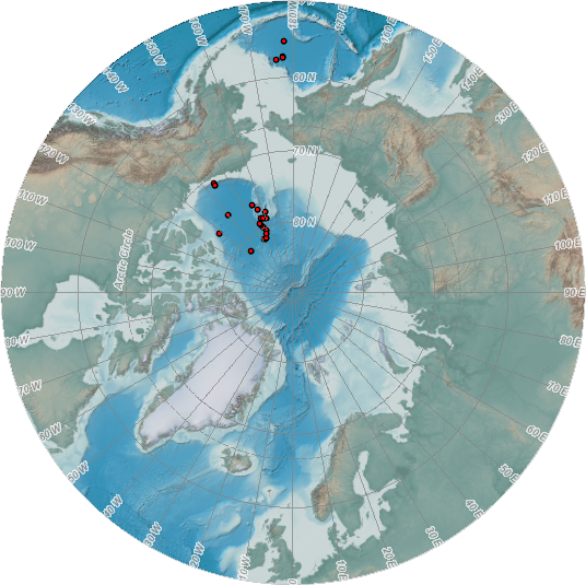 image of sea floor sample locations
Geological samples collected as part of the U.S. Extended Continental Shelf (ECS) Project are curated by the U.S. Geological Survey, a partner in the ECS Project.
To date, dredges and cores have been collected from the Arctic Ocean floor, and small sediment samples have also been collected from the Bering Sea.
According to ECS policy, application can be made by qualified researchers to the ECS Samples Curator to obtain portions of these samples for study.
Related sample data, information, and images generated at sea, during ECS post-cruise working parties, and other research results
are available for public access via the ECS Information Management System (ECS IMS) website maintained by NOAA's NCEI.
Both ECS samples and related data are searchable through the Index to Marine and Lacustrine Geological Samples (IMLGS) database maintained by NCEI.
Dataset Citation
- Cite as: U.S. Extended Continental Shelf Project (ECS). 2008: Archive of Geosample Data and Information from the U.S. Extended Continental Shelf (ECS) Project. NOAA National Centers for Environmental Information. https://doi.org/10.7289/V5GF0RG9. Accessed [date].
Dataset Identifiers
- doi:10.7289/V5GF0RG9
- NCEI Metadata ID: gov.noaa.ngdc.mgg.geology:archived-data_ECS-samples-repository
ISO 19115-2 Metadata
gov.noaa.ngdc.mgg.geology:archived-data_ECS-samples-repository
| Search Data |
|
| Download Data |
|
| Distribution Formats |
|
| Ordering Instructions | Contact NCEI for other distribution options and instructions. |
| Distributor |
NOAA National Centers for Environmental Information ncei.info@noaa.gov |
| Dataset Point of Contact |
NOAA National Centers for Environmental Information ncei.info@noaa.gov |
| Dataset Point of Contact | Marine Geology Data Manager NOAA National Centers for Environmental Information geology.info@noaa.gov |
| Coverage Description | Arctic Ocean, Bering Sea |
| Time Period | 2008-08-31T00:00:00.000Z to 2012-09-22T00:00:00.000Z |
| Spatial Reference System | urn:ogc:def:crs:EPSG:4326 |
| Spatial Bounding Box Coordinates |
West: -177.7997
East: -128.62745
South: 55.15945
North: 81.57966
|
| Spatial Coverage Map |
| General Documentation |
|
| Associated Resources |
|
| Publication Dates |
|
| Data Presentation Form | Digital table - digital representation of facts or figures systematically displayed, especially in columns Digital image |
| Dataset Progress Status | Ongoing - data is continually being updated Historical archive - data has been stored in an offline storage facility |
| Data Update Frequency | Irregular - ECS core data are collected infrequently, no new samples have been collected since 2012. |
| Supplemental Information | While the ECS project is committed to transparency and public release of data collected as part of the ECS project, this approach is not always practical or possible for sensitive or otherwise restricted data sets data collected outside of the ECS project that are not currently publicly available may need to be handled differently. The ECS project will address the terms of access and use of such data on a case-by-case basis in conjunction with the entity responsible for such data. The ECS project will encourage the owners of all non-public data to make such data public, particularly for use by the ECS project and especially if the data were collected with government funds. |
| Purpose | The first priority for geologic samples collected as part of the U.S. ECS Project is their application to delineating the U.S. ECS, however the ECS Task Force recognizes the important scientific value of these samples and encourages their study and the open publication of related scientific findings. The purpose of adding information about the ECS geological samples collection to the IMLGS is to promote new research on existing samples. |
| Use Limitations |
|
| Dataset Citation |
|
| Cited Authors |
|
| Originators |
|
| Custodians |
|
| Sponsors |
|
| Publishers |
|
| Acknowledgments |
|
| Theme keywords |
Library of Congress Subject Headings
|
| Data Center keywords |
Global Change Master Directory (GCMD) Data Center Keywords
|
| Platform keywords |
Global Change Master Directory (GCMD) Platform Keywords
|
| Instrument keywords |
Global Change Master Directory (GCMD) Instrument Keywords
|
| Place keywords |
Global Change Master Directory (GCMD) Location Keywords
|
| Project keywords |
Global Change Master Directory (GCMD) Project Keywords
|
| Use Constraints |
|
| Access Constraints |
|
| Other Constraints | Cite as: U.S. Extended Continental Shelf Project (ECS). 2008: Archive of Geosample Data and Information from the U.S. Extended Continental Shelf (ECS) Project. NOAA National Centers for Environmental Information. https://doi.org/10.7289/V5GF0RG9. Accessed [date]. |
| Fees |
|
| Lineage information for: dataset | |
|---|---|
| Lineage Statement | Incoming data were checked for adherence to controlled vocabularies, illegal data types in numeric fields, and out of range latitudes/longitudes. NCEI added IGSNs/links to related resources, where known, and performed cursory visual inspection of data for reasonableness, asking the originator for guidance on discrepancies. |
| Processor |
|
| Processing Environment | Native Dataset Environment: database tables with auxiliary text, images, and PDF documents. |
| Source Datasets |
|
| Lineage information for: repository | |
|---|---|
| Processing Steps |
|
| Acquisition Information (collection) | |
|---|---|
| Instrument |
|
| Platform | |
Last Modified: 2020-04-21
For questions about the information on this page, please email: ncei.info@noaa.gov
For questions about the information on this page, please email: ncei.info@noaa.gov