Archive of Geosample Information from Scientific Ocean Drilling
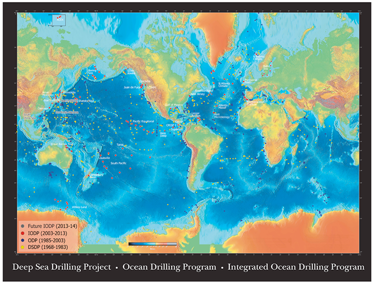 IODP drill sites
Texas A and M University (TAMU), JOIDES Resolution Science Operator of the International Ocean Discovery Program (IODP), is a partner in the Index to Marine and Lacustrine Geological Samples (IMLGS) database, contributing information to the IMLGS to help researchers discover geological samples curated in their facility. The IODP core repositories archive and make available core material from the current IODP, and also from its predecessor programs, the Deep Sea Drilling Project (DSDP), Ocean Drilling Program (ODP), and Integrated Ocean Drilling Program (IODP). Core material is available to researchers through the IODP Curator. TAMU also contributed information to the IMLGS describing cores from the former IODP and ODP in their role as Science Operator for those programs. Information describing DSDP cores for the IMLGS was prepared by the former DSDP data management group operated by the Scripps Institution of Oceanography (SIO). TAMU periodically sends post-moratorium IODP core data, documents, and imagery to NCEI for long-term archive. The latest IODP data, and full-resolution TIFF images are available from the Data Librarian at TAMU. Full-resolution TIFF images in the NCEI archive are offline only.
- Cite as: International Ocean Discovery Program (IODP). 2015: Archive of Geosample Information from Scientific Ocean Drilling. NOAA National Centers for Environmental Information. https://doi.org/10.7289/V57M05XN. Accessed [date].
- doi:10.7289/V57M05XN
- NCEI Metadata ID: gov.noaa.ngdc.mgg.geology:archived-data_IODP-sample-repository
gov.noaa.ngdc.mgg.geology:archived-data_IODP-sample-repository
| Search Data |
-
Web forms interface (search)
Text interface enabling search (DSDP, ODP, IODP), data download, and links to related data via the Index to Marine and Lacustrine Geological Samples (IMLGS).
-
Map viewer (search)
ArcGIS interactive map interface enabling search (DSDP, ODP, IODP), data download, and links to related data via the Index to Marine and Lacustrine Geological Samples (IMLGS).
|
| Download Data |
-
Data files (download)
Direct link to data from JOIDES Resolution/ODP/IODP Expeditions(images offline only)
-
Data files (download)
Direct link to data from Glomar Challenger/DSDP Expeditions(images offline only)
|
| Distribution Formats |
|
| Ordering Instructions |
Contact NCEI for other distribution options and instructions. |
| Distributor |
NOAA National Centers for Environmental Information
ncei.info@noaa.gov
|
| Dataset Point of Contact |
NOAA National Centers for Environmental Information
ncei.info@noaa.gov
|
| Dataset Point of Contact |
Marine Geology Data Manager
NOAA National Centers for Environmental Information
geology.info@noaa.gov
|
| Coverage Description |
Global ocean sea floor |
| Time Period |
1968-08-11 to Present |
| Spatial Reference System |
urn:ogc:def:crs:EPSG:4326 |
| Spatial Bounding Box Coordinates |
West: -179.5558
East: 179.738
South: -77.442
North: 80.4747
|
| Spatial Coverage Map |
|
| General Documentation |
|
| Associated Resources |
- Index to Marine and Lacustrine Geological Samples (IMLGS)
-
Parent Database
The parent IMLGS database contains more/related data and information.
- Archive of Core and Site/Hole Data and Photographs from the Integrated Ocean Drilling Program (IODP)
- Archive of Core and Site/Hole Data and Photographs from the Ocean Drilling Program (ODP)
- Archive of Core and Site/Hole Data and Photographs from the Deep Sea Drilling Project (DSDP)
- NCEI Marine Geology Data Archive
-
Parent Archive
Information about the Marine Geology Data Archive at NCEI.
- NOAA/NCEI Marine Geology WAF
|
| Publication Dates |
- publication: 1977-12-31
- revision: 2015-06-30
|
| Data Presentation Form |
Digital table - digital representation of facts or figures systematically displayed, especially in columns
Digital image
Digital document - digital representation of a primarily textual item (can contain illustrations also)
|
| Dataset Progress Status |
Ongoing - data is continually being updated
Historical archive - data has been stored in an offline storage facility |
| Data Update Frequency |
Irregular - No data have been received for the new International Ocean Discovery Program (IODP) cores; Integrated Ocean Drilling Program (IODP) Expeditions were completed in 2013. DSDP and ODP Legs are also complete. Data will continue to be added to the long-term archive as they come out of moratorium. |
| Supplemental Information |
These data were prepared for archive at NGDC by the IODP staff at Texas A and M University (TAMU), to fulfill the requirements of the US National Science Foundation's "Policy for Oceanographic Data", NSF document 11-004. |
| Purpose |
Marine geological and geophysical research. Research into the deep biosphere and the subseafloor ocean; Environmental change, processes and effects; and Solid earth cycles and geodynamics. |
| Use Limitations |
- Produced by the NOAA National Centers for Environmental Information. Not subject to copyright protection within the United States.
|
| Dataset Citation |
- Cite as: International Ocean Discovery Program (IODP). 2015: Archive of Geosample Information from Scientific Ocean Drilling. NOAA National Centers for Environmental Information. https://doi.org/10.7289/V57M05XN. Accessed [date].
|
| Cited Authors |
- International Ocean Discovery Program (IODP)
|
| Originators |
- John Firth, Curator
International Ocean Discovery Program (IODP)
- Phil Rumford, Superintendent, Gulf Coast Repository
International Ocean Discovery Program (IODP)
- Christine Mato, former Curator
Ocean Drilling Program (ODP)
- Peter Woodbury, former DSDP Database Manager
Deep Sea Drilling Project (DSDP)
|
| Sponsors |
- National Science Foundation (NSF)
|
| Points of Contact |
- Don Simms, Data Librarian
Texas A and M University, JOIDES Resolution Science Operator, International Ocean Discovery Program (IODP)
|
| Publishers |
- NOAA National Centers for Environmental Information
|
| Acknowledgments |
- IODP and ODP core data were compiled by Texas A and M University. Core data for the DSDP were compiled by Scripps Institution of Oceanography, Science Operator for the Deep Sea Drilling Project. DSDP, ODP, and IODP data were compiled with support from the U.S. National Science Foundation (NSF), and international sources.
|
| Theme keywords |
Library of Congress Subject Headings
- Scientific archives
- Electronic records
- Oceanography
- Ocean bottom
- Geology
- Submarine geology
- Marine sediments
SeaDataNet Common Vocabularies
USGS Science Topics- Sea-floor characteristics
Global Change Master Directory (GCMD) Science Keywords
- Earth Science > Oceans > Marine Sediments > Geotechnical Properties
- Earth Science > Oceans > Marine Sediments > Sediment Chemistry
- Earth Science > Oceans > Marine Sediments > Sediment Composition
- Earth Science > Paleoclimate > Ocean/Lake Records > Boreholes
- Earth Science > Paleoclimate > Ocean/Lake Records > Isotopes
- Earth Science > Paleoclimate > Ocean/Lake Records > Macrofossils
- Earth Science > Paleoclimate > Ocean/Lake Records > Microfossils
- Earth Science > Paleoclimate > Ocean/Lake Records > Paleomagnetic Data
- Earth Science > Paleoclimate > Ocean/Lake Records > Sediments
- Earth Science > Solid Earth > Rocks/Minerals/Crystals > Major Elements
- Earth Science > Solid Earth > Rocks/Minerals/Crystals > Minor Elements
- Earth Science > Solid Earth > Rocks/Minerals/Crystals > Trace Elements
- Earth Science > Solid Earth > Geomagnetism > Paleomagnetism
- Earth Science > Solid Earth > Rocks/Minerals/Crystals > Age Determinations
- Earth Science > Solid Earth > Rocks/Minerals/Crystals > Igneous Rocks
- Earth Science > Solid Earth > Rocks/Minerals/Crystals > Metamorphic Rocks
- Earth Science > Solid Earth > Rocks/Minerals/Crystals > Sedimentary Rocks
- Earth Science > Solid Earth > Rocks/Minerals/Crystals > Sediments
- Earth Science > OCEANS > Marine Sediments > Stratigraphic Sequence
- Earth Science > PALEOCLIMATE > Ocean/Lake Records > Stratigraphic Sequence
|
| Data Center keywords |
Global Change Master Directory (GCMD) Data Center Keywords
- DOC/NOAA/NESDIS/NCEI > National Centers for Environmental Information, NESDIS, NOAA, U.S. Department of Commerce
- DOC/NOAA/NESDIS/NGDC > National Geophysical Data Center, NESDIS, NOAA, U.S. Department of Commerce
|
| Platform keywords |
Global Change Master Directory (GCMD) Platform Keywords- In Situ Ocean-based Platforms > Ships
|
| Instrument keywords |
Global Change Master Directory (GCMD) Instrument Keywords
- In Situ/Laboratory Instruments > Corers > Coring Devices
- In Situ/Laboratory Instruments > Corers > Rock Corers
- In Situ/Laboratory Instruments > Corers > Sediment Corers
|
| Place keywords |
Global Change Master Directory (GCMD) Location Keywords
- Solid Earth > Crust
- Geographic Region > Global Ocean
- Vertical Location >Sea Floor
|
| Project keywords |
Global Change Master Directory (GCMD) Project Keywords- IODP > International Ocean Discovery Program
Global Change Master Directory (GCMD) Project Keywords
Global Change Master Directory (GCMD) Project Keywords- ICSU-WDS > International Council for Science - World Data System
|
| Use Constraints |
- Use liability: NOAA and NCEI cannot provide any warranty as to the accuracy, reliability, or completeness of furnished data. Users assume responsibility to determine the usability of these data. The user is responsible for the results of any application of this data for other than its intended purpose.
- While every effort has been made to ensure that these data are accurate and reliable within the limits of the current state of the art, NOAA cannot assume liability for any damages caused by any errors or omissions in the data, nor as a result of the failure of the data to function on a particular system. NOAA makes no warranty, expressed or implied, nor does the fact of distribution constitute such a warranty.
|
| Access Constraints |
- Distribution liability: NOAA and NCEI make no warranty, expressed or implied, regarding these data, nor does the fact of distribution constitute such a warranty. NOAA and NCEI cannot assume liability for any damages caused by any errors or omissions in these data. If appropriate, NCEI can only certify that the data it distributes are an authentic copy of the records that were accepted for inclusion in the NCEI archives.
- Access to this dataset is unrestricted.
|
| Other Constraints |
Cite as: International Ocean Discovery Program (IODP). 2015: Archive of Geosample Information from Scientific Ocean Drilling. NOAA National Centers for Environmental Information. https://doi.org/10.7289/V57M05XN. Accessed [date]. |
| Fees |
- In most cases, electronic downloads of the data are free. However, fees may apply for custom orders, data certifications, copies of analog materials, and data distribution on physical media.
|
| Lineage information for: dataset |
|---|
| Lineage Statement |
Information about cores obtained by the Glomar Challenger during the Deep Sea Drilling Project (DSDP) was compiled by the DSDP Project Office at the Scripps Institution of Oceanography. Information pertaining to cores obtained by the JOIDES Resolution during the Ocean Drilling Program (ODP), Integrated Ocean Drilling Program (IODP), and International Ocean Discovery Program (IODP) was compiled by Texas A and M University (TAMU), Science Operator for the ODP and IODP. Digital data origin varies by program. DSDP data were exported from the SIO Burroughs server. Some ODP data prior to Leg 129 were exported from the 1032 database management system at TAMU. ODP and IODP core data from JOIDES Resolution Expeditions 129 to 317 were exported from the JANUS database system at TAMU. Data for Expedition 317 and higher were processed through the LIMS system at TAMU. |
| Processor |
- NOAA National Centers for Environmental Information
|
| Processing Environment |
Native Dataset Environment: ASCII text |
| Source Datasets |
- DSDP, ODP, and IODP Databases.
- Description of Source: Current source, Texas A and M University, JOIDES Resolution Science Operator, International Ocean Discovery Program
|
| Lineage information for: repository |
|---|
| Processing Steps |
- 2015-04-22T00:00:00 - NOAA created the National Centers for Environmental Information (NCEI) by merging NOAA's National Climatic Data Center (NCDC), National Geophysical Data Center (NGDC), and National Oceanographic Data Center (NODC), including the National Coastal Data Development Center (NCDDC), per the Consolidated and Further Continuing Appropriations Act, 2015, Public Law 113-235. NCEI launched publicly on April 22, 2015.
|
| Acquisition Information (collection) |
|---|
| Instrument |
- In Situ/Laboratory Instruments
- APC
- Half APC
- RCB
- XCB
- MDCB
- PCS
- In Situ/Laboratory Instruments
- In Situ/Laboratory Instruments
|
| Platform |
|
Last Modified: 2020-04-21
For questions about the information on this page, please email:
ncei.info@noaa.gov