Archive of Geosample Information from Scientific Ocean Drilling
- spatialRepresentationInfo
- referenceSystemInfo
- identificationInfo
- contentInfo
- contentInfo
- contentInfo
- contentInfo
- distributionInfo
- dataQualityInfo
- dataQualityInfo
- metadataMaintenance
- acquisitionInformation
- acquisitionInformation
(MI_Metadata)
fileIdentifier: gov.noaa.ngdc.mgg.geology:archived-data_IODP-sample-repository
hierarchyLevel: (MD_ScopeCode) dataset
contact: (CI_ResponsibleParty)
organisationName: NOAA National Centers for Environmental Information
contactInfo: (CI_Contact)
address: (CI_Address)
electronicMailAddress: ncei.info@noaa.gov
onlineResource: (CI_OnlineResource)
linkage: https://www.ncei.noaa.gov/contact
name: NCEI Contact Information
description: Information for contacts at NCEI.
function: (CI_OnLineFunctionCode) information
role: (CI_RoleCode) pointOfContact
dateStamp: 2020-04-21
metadataStandardName: ISO 19115-2 Geographic Information - Metadata - Part 2: Extensions for Imagery and Gridded Data
metadataStandardVersion: ISO 19115-2:2009(E)
return to top
spatialRepresentationInfo: (MD_VectorSpatialRepresentation)
geometricObjects: (MD_GeometricObjects)
geometricObjectType: (MD_GeometricObjectTypeCode) point
return to top
referenceSystemInfo: (MD_ReferenceSystem)
referenceSystemIdentifier: (RS_Identifier)
authority: (CI_Citation)
title: European Petroleum Survey Group (EPSG) Geodetic Parameter Registry
date: (CI_Date)
date: 2008-11-12
dateType: (CI_DateTypeCode) publication
citedResponsibleParty: (CI_ResponsibleParty)
organisationName: European Petroleum Survey Group
contactInfo: (CI_Contact)
onlineResource: (CI_OnlineResource)
linkage: http://www.epsg-registry.org/
name: European Petroleum Survey Group Geodetic Parameter Dataset
description: Registry that accesses the EPSG Geodetic Parameter Dataset, which is a structured dataset of Coordinate Reference Systems and Coordinate Transformations.
function: (CI_OnLineFunctionCode) search
role: (inapplicable)
code: urn:ogc:def:crs:EPSG:4326
version: 6.18.3
return to top
identificationInfo: (MD_DataIdentification)
citation: (CI_Citation)
title: Archive of Geosample Information from Scientific Ocean Drilling
date: (CI_Date)
date: 1977-12-31
dateType: (CI_DateTypeCode) publication
date: (CI_Date)
date: 2015-06-30
dateType: (CI_DateTypeCode) revision
identifier: (MD_Identifier)
authority: (CI_Citation)
title: International DOI Foundation (IDF)
date: (inapplicable)
code:
Anchor: DOI doi:10.7289/V57M05XN
identifier: (MD_Identifier)
authority: (CI_Citation)
title: NOAA National Centers for Environmental Information
date: (inapplicable)
code: NCEI Metadata ID: gov.noaa.ngdc.mgg.geology:archived-data_IODP-sample-repository
citedResponsibleParty: (CI_ResponsibleParty)
organisationName: International Ocean Discovery Program (IODP)
role: (CI_RoleCode) author
citedResponsibleParty: (CI_ResponsibleParty)
individualName: John Firth, Curator
organisationName: International Ocean Discovery Program (IODP)
role: (CI_RoleCode) originator
citedResponsibleParty: (CI_ResponsibleParty)
individualName: Phil Rumford, Superintendent, Gulf Coast Repository
organisationName: International Ocean Discovery Program (IODP)
role: (CI_RoleCode) originator
citedResponsibleParty: (CI_ResponsibleParty)
individualName: Christine Mato, former Curator
organisationName: Ocean Drilling Program (ODP)
role: (CI_RoleCode) originator
citedResponsibleParty: (CI_ResponsibleParty)
individualName: Don Simms, Data Librarian
organisationName: Texas A and M University, JOIDES Resolution Science Operator, International Ocean Discovery Program (IODP)
positionName: Data Librarian
role: (CI_RoleCode) pointOfContact
citedResponsibleParty: (CI_ResponsibleParty)
individualName: Peter Woodbury, former DSDP Database Manager
organisationName: Deep Sea Drilling Project (DSDP)
role: (CI_RoleCode) originator
citedResponsibleParty: (CI_ResponsibleParty)
organisationName: National Science Foundation (NSF)
role: (CI_RoleCode) sponsor
citedResponsibleParty: (CI_ResponsibleParty)
organisationName: NOAA National Centers for Environmental Information
role: (CI_RoleCode) publisher
presentationForm: (CI_PresentationFormCode) tableDigital
presentationForm: (CI_PresentationFormCode) imageDigital
presentationForm: (CI_PresentationFormCode) documentDigital
series: (CI_Series)
name: NCEI/WDS for Geophysics digital data set
issueIdentification: IMLGS services layers IODP, DSDP, and ODP and discrete data sets MGG15055001 through MGG15055999, and MGG23065001 through MGG23065999
otherCitationDetails: The DSDP, ODP, and IODP each operated/operate a partner core repository, contributing data to the Index to Marine and Lacustrine Geological Samples (IMLGS) database. The IMLGS is a collaboration between NCEI and multiple institutions (some supported by NSF) and government agencies, created by the institutions to offer common data about, and discovery/access to geological samples in their sample repository collections. The purpose of the IMLGS is to promote new research on existing samples. The database is maintained by NCEI under the guidance of a Curators Consortium, composed of representatives from the partner institutions.
abstract: Texas A and M University (TAMU), JOIDES Resolution Science Operator of the International Ocean Discovery Program (IODP), is a partner in the Index to Marine and Lacustrine Geological Samples (IMLGS) database, contributing information to the IMLGS to help researchers discover geological samples curated in their facility. The IODP core repositories archive and make available core material from the current IODP, and also from its predecessor programs, the Deep Sea Drilling Project (DSDP), Ocean Drilling Program (ODP), and Integrated Ocean Drilling Program (IODP). Core material is available to researchers through the IODP Curator. TAMU also contributed information to the IMLGS describing cores from the former IODP and ODP in their role as Science Operator for those programs. Information describing DSDP cores for the IMLGS was prepared by the former DSDP data management group operated by the Scripps Institution of Oceanography (SIO). TAMU periodically sends post-moratorium IODP core data, documents, and imagery to NCEI for long-term archive. The latest IODP data, and full-resolution TIFF images are available from the Data Librarian at TAMU. Full-resolution TIFF images in the NCEI archive are offline only.
purpose: Marine geological and geophysical research. Research into the deep biosphere and the subseafloor ocean; Environmental change, processes and effects; and Solid earth cycles and geodynamics.
credit: IODP and ODP core data were compiled by Texas A and M University. Core data for the DSDP were compiled by Scripps Institution of Oceanography, Science Operator for the Deep Sea Drilling Project. DSDP, ODP, and IODP data were compiled with support from the U.S. National Science Foundation (NSF), and international sources.
status: (MD_ProgressCode) onGoing
status: (MD_ProgressCode) historicalArchive
pointOfContact: (CI_ResponsibleParty)
organisationName: NOAA National Centers for Environmental Information
contactInfo: (CI_Contact)
address: (CI_Address)
electronicMailAddress: ncei.info@noaa.gov
onlineResource: (CI_OnlineResource)
linkage: https://www.ncei.noaa.gov/contact
name: NCEI Contact Information
description: Information for contacts at NCEI.
function: (CI_OnLineFunctionCode) information
role: (CI_RoleCode) pointOfContact
pointOfContact: (CI_ResponsibleParty)
organisationName: NOAA National Centers for Environmental Information
positionName: Marine Geology Data Manager
contactInfo: (CI_Contact)
address: (CI_Address)
deliveryPoint: 325 Broadway, Mail Code E/NE42
city: Boulder
administrativeArea: CO
postalCode: 80305-3328
country: USA
electronicMailAddress: geology.info@noaa.gov
role: (CI_RoleCode) pointOfContact
resourceMaintenance: (MD_MaintenanceInformation)
maintenanceAndUpdateFrequency: (MD_MaintenanceFrequencyCode) irregular
maintenanceNote: No data have been received for the new International Ocean Discovery Program (IODP) cores; Integrated Ocean Drilling Program (IODP) Expeditions were completed in 2013. DSDP and ODP Legs are also complete. Data will continue to be added to the long-term archive as they come out of moratorium.
graphicOverview: (MD_BrowseGraphic)
fileName: https://www.ngdc.noaa.gov/mgg/image/ScientificOceanDrillingProgramUSIO.png
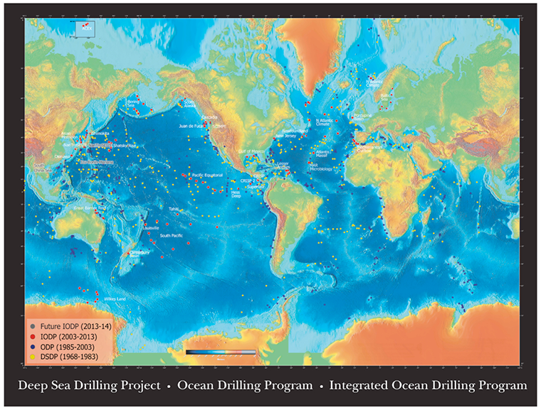
fileDescription: IODP drill sites
fileType: PNG
descriptiveKeywords: (MD_Keywords)
keyword: IODP > International Ocean Discovery Program
type: (MD_KeywordTypeCode) project
thesaurusName: (CI_Citation)
title: Global Change Master Directory (GCMD) Project Keywords
date: (CI_Date)
date: 2020-01-09
dateType: (CI_DateTypeCode) publication
edition: 9.1
citedResponsibleParty: (CI_ResponsibleParty)
organisationName: NASA Goddard Space Flight Center, Earth Science Data and Information System
contactInfo: (CI_Contact)
onlineResource: (CI_OnlineResource)
linkage: https://www.earthdata.nasa.gov/learn/find-data/idn/gcmd-keywords
name: Global Change Master Directory (GCMD) Keywords
description: The information provided on this page seeks to define how the GCMD Keywords are structured, used and accessed. It also provides information on how users can participate in the further development of the keywords.
function: (CI_OnLineFunctionCode) information
role: (CI_RoleCode) custodian
descriptiveKeywords: (MD_Keywords)
keyword: Scientific archives
keyword: Electronic records
keyword: Oceanography
keyword: Ocean bottom
keyword: Geology
keyword: Submarine geology
keyword: Marine sediments
type: (MD_KeywordTypeCode) theme
thesaurusName: (CI_Citation)
title: Library of Congress Subject Headings
date: (unknown)
citedResponsibleParty: (CI_ResponsibleParty)
organisationName: US Library of Congress
contactInfo: (CI_Contact)
onlineResource: (CI_OnlineResource)
linkage: http://id.loc.gov/authorities/subjects
protocol: http
applicationProfile: web browser
name: Library of Congress Subject Headings (LCSH)
description: The Library of Congress Subject Headings (LCSH) are part of a Linked Data Service, actively maintained since 1898 to catalog materials held at the Library of Congress.
function: (CI_OnLineFunctionCode) information
role: (CI_RoleCode) resourceProvider
descriptiveKeywords: (MD_Keywords)
keyword: Marine geology
type: (MD_KeywordTypeCode) theme
thesaurusName: (CI_Citation)
title: SeaDataNet Common Vocabularies
date: (unknown)
citedResponsibleParty: (CI_ResponsibleParty)
organisationName: SeaDataNet
contactInfo: (CI_Contact)
onlineResource: (CI_OnlineResource)
linkage: http://www.seadatanet.org/Standards-Software/Common-Vocabularies
protocol: http
applicationProfile: web browser
name: SeaDataNet Common Vocabularies
description: The SeaDataNet Vocabulary Server is populated with lists describing a wide range of entities relevant to marine metadata and data such as parameters, sea area names, platform classes, instrument types, and so on.
function: (CI_OnLineFunctionCode) information
role: (CI_RoleCode) resourceProvider
descriptiveKeywords: (MD_Keywords)
keyword: Sea-floor characteristics
type: (MD_KeywordTypeCode) theme
thesaurusName: (CI_Citation)
title: USGS Science Topics
date: (unknown)
citedResponsibleParty: (CI_ResponsibleParty)
organisationName: US Geological Survey
contactInfo: (CI_Contact)
onlineResource: (CI_OnlineResource)
linkage: https://www2.usgs.gov/science/about/
protocol: http
applicationProfile: web browser
name: USGS Thesaurus
description: The USGS Thesaurus contains thematic terms for categorizing information resources intended to support finding and understanding scientific information.
function: (CI_OnLineFunctionCode) information
role: (CI_RoleCode) resourceProvider
descriptiveKeywords: (MD_Keywords)
keyword: Earth Science > Oceans > Marine Sediments > Geotechnical Properties
keyword: Earth Science > Oceans > Marine Sediments > Sediment Chemistry
keyword: Earth Science > Oceans > Marine Sediments > Sediment Composition
keyword: Earth Science > Paleoclimate > Ocean/Lake Records > Boreholes
keyword: Earth Science > Paleoclimate > Ocean/Lake Records > Isotopes
keyword: Earth Science > Paleoclimate > Ocean/Lake Records > Macrofossils
keyword: Earth Science > Paleoclimate > Ocean/Lake Records > Microfossils
keyword: Earth Science > Paleoclimate > Ocean/Lake Records > Paleomagnetic Data
keyword: Earth Science > Paleoclimate > Ocean/Lake Records > Sediments
keyword: Earth Science > Solid Earth > Rocks/Minerals/Crystals > Major Elements
keyword: Earth Science > Solid Earth > Rocks/Minerals/Crystals > Minor Elements
keyword: Earth Science > Solid Earth > Rocks/Minerals/Crystals > Trace Elements
keyword: Earth Science > Solid Earth > Geomagnetism > Paleomagnetism
keyword: Earth Science > Solid Earth > Rocks/Minerals/Crystals > Age Determinations
keyword: Earth Science > Solid Earth > Rocks/Minerals/Crystals > Igneous Rocks
keyword: Earth Science > Solid Earth > Rocks/Minerals/Crystals > Metamorphic Rocks
keyword: Earth Science > Solid Earth > Rocks/Minerals/Crystals > Sedimentary Rocks
keyword: Earth Science > Solid Earth > Rocks/Minerals/Crystals > Sediments
keyword: Earth Science > OCEANS > Marine Sediments > Stratigraphic Sequence
keyword: Earth Science > PALEOCLIMATE > Ocean/Lake Records > Stratigraphic Sequence
type: (MD_KeywordTypeCode) theme
thesaurusName: (CI_Citation)
title: Global Change Master Directory (GCMD) Science Keywords
date: (CI_Date)
date: 2020-01-09
dateType: (CI_DateTypeCode) publication
edition: 9.1
citedResponsibleParty: (CI_ResponsibleParty)
organisationName: NASA Goddard Space Flight Center, Earth Science Data and Information System
contactInfo: (CI_Contact)
onlineResource: (CI_OnlineResource)
linkage: https://www.earthdata.nasa.gov/learn/find-data/idn/gcmd-keywords
name: Global Change Master Directory (GCMD) Keywords
description: The information provided on this page seeks to define how the GCMD Keywords are structured, used and accessed. It also provides information on how users can participate in the further development of the keywords.
function: (CI_OnLineFunctionCode) information
role: (CI_RoleCode) custodian
descriptiveKeywords: (MD_Keywords)
keyword: In Situ Ocean-based Platforms > Ships
type: (MD_KeywordTypeCode) platform
thesaurusName: (CI_Citation)
title: Global Change Master Directory (GCMD) Platform Keywords
date: (CI_Date)
date: 2020-01-09
dateType: (CI_DateTypeCode) publication
edition: 9.1
citedResponsibleParty: (CI_ResponsibleParty)
organisationName: NASA Goddard Space Flight Center, Earth Science Data and Information System
contactInfo: (CI_Contact)
onlineResource: (CI_OnlineResource)
linkage: https://www.earthdata.nasa.gov/learn/find-data/idn/gcmd-keywords
name: Global Change Master Directory (GCMD) Keywords
description: The information provided on this page seeks to define how the GCMD Keywords are structured, used and accessed. It also provides information on how users can participate in the further development of the keywords.
function: (CI_OnLineFunctionCode) information
role: (CI_RoleCode) custodian
descriptiveKeywords: (MD_Keywords)
keyword: In Situ/Laboratory Instruments > Corers > Coring Devices
keyword: In Situ/Laboratory Instruments > Corers > Rock Corers
keyword: In Situ/Laboratory Instruments > Corers > Sediment Corers
type: (MD_KeywordTypeCode) instrument
thesaurusName: (CI_Citation)
title: Global Change Master Directory (GCMD) Instrument Keywords
date: (CI_Date)
date: 2020-01-09
dateType: (CI_DateTypeCode) publication
edition: 9.1
citedResponsibleParty: (CI_ResponsibleParty)
organisationName: NASA Goddard Space Flight Center, Earth Science Data and Information System
contactInfo: (CI_Contact)
onlineResource: (CI_OnlineResource)
linkage: https://www.earthdata.nasa.gov/learn/find-data/idn/gcmd-keywords
name: Global Change Master Directory (GCMD) Keywords
description: The information provided on this page seeks to define how the GCMD Keywords are structured, used and accessed. It also provides information on how users can participate in the further development of the keywords.
function: (CI_OnLineFunctionCode) information
role: (CI_RoleCode) custodian
descriptiveKeywords: (MD_Keywords)
keyword: IMLGS
type: (MD_KeywordTypeCode) project
thesaurusName: (CI_Citation)
title: Global Change Master Directory (GCMD) Project Keywords
date: (CI_Date)
date: 2020-01-09
dateType: (CI_DateTypeCode) publication
edition: 9.1
citedResponsibleParty: (CI_ResponsibleParty)
organisationName: NASA Goddard Space Flight Center, Earth Science Data and Information System
contactInfo: (CI_Contact)
onlineResource: (CI_OnlineResource)
linkage: https://www.earthdata.nasa.gov/learn/find-data/idn/gcmd-keywords
name: Global Change Master Directory (GCMD) Keywords
description: The information provided on this page seeks to define how the GCMD Keywords are structured, used and accessed. It also provides information on how users can participate in the further development of the keywords.
function: (CI_OnLineFunctionCode) information
role: (CI_RoleCode) custodian
descriptiveKeywords: (MD_Keywords)
keyword: ICSU-WDS > International Council for Science - World Data System
type: (MD_KeywordTypeCode) project
thesaurusName: (CI_Citation)
title: Global Change Master Directory (GCMD) Project Keywords
date: (CI_Date)
date: 2020-01-09
dateType: (CI_DateTypeCode) publication
edition: 9.1
citedResponsibleParty: (CI_ResponsibleParty)
organisationName: NASA Goddard Space Flight Center, Earth Science Data and Information System
contactInfo: (CI_Contact)
onlineResource: (CI_OnlineResource)
linkage: https://www.earthdata.nasa.gov/learn/find-data/idn/gcmd-keywords
name: Global Change Master Directory (GCMD) Keywords
description: The information provided on this page seeks to define how the GCMD Keywords are structured, used and accessed. It also provides information on how users can participate in the further development of the keywords.
function: (CI_OnLineFunctionCode) information
role: (CI_RoleCode) custodian
descriptiveKeywords: (MD_Keywords)
keyword: DOC/NOAA/NESDIS/NCEI > National Centers for Environmental Information, NESDIS, NOAA, U.S. Department of Commerce
keyword: DOC/NOAA/NESDIS/NGDC > National Geophysical Data Center, NESDIS, NOAA, U.S. Department of Commerce
type: (MD_KeywordTypeCode) dataCentre
thesaurusName: (CI_Citation)
title: Global Change Master Directory (GCMD) Data Center Keywords
date: (CI_Date)
date: 2020-01-09
dateType: (CI_DateTypeCode) publication
edition: 9.1
citedResponsibleParty: (CI_ResponsibleParty)
organisationName: NASA Goddard Space Flight Center, Earth Science Data and Information System
contactInfo: (CI_Contact)
onlineResource: (CI_OnlineResource)
linkage: https://www.earthdata.nasa.gov/learn/find-data/idn/gcmd-keywords
name: Global Change Master Directory (GCMD) Keywords
description: The information provided on this page seeks to define how the GCMD Keywords are structured, used and accessed. It also provides information on how users can participate in the further development of the keywords.
function: (CI_OnLineFunctionCode) information
role: (CI_RoleCode) custodian
descriptiveKeywords: (MD_Keywords)
keyword: Solid Earth > Crust
keyword: Geographic Region > Global Ocean
keyword: Vertical Location >Sea Floor
type: (MD_KeywordTypeCode) place
thesaurusName: (CI_Citation)
title: Global Change Master Directory (GCMD) Location Keywords
date: (CI_Date)
date: 2020-01-09
dateType: (CI_DateTypeCode) publication
edition: 9.1
citedResponsibleParty: (CI_ResponsibleParty)
organisationName: NASA Goddard Space Flight Center, Earth Science Data and Information System
contactInfo: (CI_Contact)
onlineResource: (CI_OnlineResource)
linkage: https://www.earthdata.nasa.gov/learn/find-data/idn/gcmd-keywords
name: Global Change Master Directory (GCMD) Keywords
description: The information provided on this page seeks to define how the GCMD Keywords are structured, used and accessed. It also provides information on how users can participate in the further development of the keywords.
function: (CI_OnLineFunctionCode) information
role: (CI_RoleCode) custodian
resourceConstraints: (MD_LegalConstraints)
accessConstraints: (MD_RestrictionCode) otherRestrictions
otherConstraints: Distribution liability: NOAA and NCEI make no warranty, expressed or implied, regarding these data, nor does the fact of distribution constitute such a warranty. NOAA and NCEI cannot assume liability for any damages caused by any errors or omissions in these data. If appropriate, NCEI can only certify that the data it distributes are an authentic copy of the records that were accepted for inclusion in the NCEI archives.
resourceConstraints: (MD_LegalConstraints)
useConstraints: (MD_RestrictionCode) otherRestrictions
otherConstraints: Use liability: NOAA and NCEI cannot provide any warranty as to the accuracy, reliability, or completeness of furnished data. Users assume responsibility to determine the usability of these data. The user is responsible for the results of any application of this data for other than its intended purpose.
resourceConstraints: (MD_LegalConstraints)
useLimitation: (MD_RestrictionCode) otherRestrictions
otherConstraints: Cite as: International Ocean Discovery Program (IODP). 2015: Archive of Geosample Information from Scientific Ocean Drilling. NOAA National Centers for Environmental Information. https://doi.org/10.7289/V57M05XN. Accessed [date].
resourceConstraints: (MD_Constraints)
useLimitation: Produced by the NOAA National Centers for Environmental Information. Not subject to copyright protection within the United States.
resourceConstraints: (MD_LegalConstraints)
useConstraints: (MD_RestrictionCode) otherRestrictions
otherConstraints: While every effort has been made to ensure that these data are accurate and reliable within the limits of the current state of the art, NOAA cannot assume liability for any damages caused by any errors or omissions in the data, nor as a result of the failure of the data to function on a particular system. NOAA makes no warranty, expressed or implied, nor does the fact of distribution constitute such a warranty.
resourceConstraints: (MD_SecurityConstraints)
classification: (MD_ClassificationCode) unclassified
resourceConstraints: (MD_LegalConstraints)
accessConstraints: (MD_RestrictionCode) otherRestrictions
otherConstraints: Access to this dataset is unrestricted.
aggregationInfo: (MD_AggregateInformation)
aggregateDataSetName: (CI_Citation)
title: Index to Marine and Lacustrine Geological Samples (IMLGS)
date: (CI_Date)
date: 1977-12-31
dateType: (CI_DateTypeCode) publication
identifier: (MD_Identifier)
code:
Anchor: DOI doi:10.7289/V5H41PB
citedResponsibleParty: (CI_ResponsibleParty)
organisationName: Curators of Marine and Lacustrine Geological Samples
role: (CI_RoleCode) author
citedResponsibleParty: (CI_ResponsibleParty)
organisationName: (inapplicable)
contactInfo: (CI_Contact)
onlineResource: (CI_OnlineResource)
linkage: https://dx.doi.org/10.7289/V5H41PB8
protocol: WWW:LINK-1.0-http--link
applicationProfile: Web Browser
name: Parent Database
description: The parent IMLGS database contains more/related data and information.
function: (CI_OnLineFunctionCode) information
role: (inapplicable)
associationType: (DS_AssociationTypeCode) largerWorkCitation
initiativeType: (DS_InitiativeTypeCode) project
aggregationInfo: (MD_AggregateInformation)
aggregateDataSetName: (CI_Citation)
title: Archive of Core and Site/Hole Data and Photographs from the Integrated Ocean Drilling Program (IODP)
date: (CI_Date)
date: 2010-12-31
dateType: (CI_DateTypeCode) publication
identifier: (MD_Identifier)
code:
Anchor: DOI doi:10.7289/V58913SM
citedResponsibleParty: (CI_ResponsibleParty)
organisationName: Integrated Ocean Drilling Program
role: (CI_RoleCode) author
citedResponsibleParty: (CI_ResponsibleParty)
organisationName: NOAA National Centers for Environmental Information
role: (CI_RoleCode) resourceProvider
citedResponsibleParty: (CI_ResponsibleParty)
organisationName: (inapplicable)
contactInfo: (CI_Contact)
onlineResource: (CI_OnlineResource)
linkage: https://doi.org/10.7289/V58913SM
protocol: WWW:LINK-1.0-http--link
applicationProfile: Web Browser
name: doi:10.7289/V58913SM
description: This data set contains related data and information.
function: (CI_OnLineFunctionCode) information
role: (inapplicable)
otherCitationDetails: Integrated Ocean Drilling Program (2010): Archive of Core and Site/Hole Data and Photographs from the Integrated Ocean Drilling Program (IODP). NOAA National Centers for Environmental Information. doi:10.7289/V58913SM
associationType: (DS_AssociationTypeCode) crossReference
initiativeType: (DS_InitiativeTypeCode) project
aggregationInfo: (MD_AggregateInformation)
aggregateDataSetName: (CI_Citation)
title: Archive of Core and Site/Hole Data and Photographs from the Ocean Drilling Program (ODP)
date: (CI_Date)
date: 2005-12-31
dateType: (CI_DateTypeCode) publication
identifier: (MD_Identifier)
code:
Anchor: DOI doi:10.7289/V5W37T8C
citedResponsibleParty: (CI_ResponsibleParty)
organisationName: Ocean Drilling Program
role: (CI_RoleCode) author
citedResponsibleParty: (CI_ResponsibleParty)
organisationName: (inapplicable)
contactInfo: (CI_Contact)
onlineResource: (CI_OnlineResource)
linkage: https://doi.org/10.7289/V5W37T8C
protocol: WWW:LINK-1.0-http--link
applicationProfile: Web Browser
name: doi:10.7289/V5W37T8C
description: This data set contains related data and information.
function: (CI_OnLineFunctionCode) information
role: (inapplicable)
otherCitationDetails: Ocean Drilling Program (2005): Archive of Core and Site/Hole Data and Photographs from the Ocean Drilling Program (ODP). NOAA National Centers for Environmental Information. doi:10.7289/V5W37T8C
associationType: (DS_AssociationTypeCode) crossReference
initiativeType: (DS_InitiativeTypeCode) project
aggregationInfo: (MD_AggregateInformation)
aggregateDataSetName: (CI_Citation)
title: Archive of Core and Site/Hole Data and Photographs from the Deep Sea Drilling Project (DSDP)
date: (CI_Date)
date: 1989-12-31
dateType: (CI_DateTypeCode) publication
identifier: (MD_Identifier)
code:
Anchor: DOI doi:10.7289/V54M92G2
citedResponsibleParty: (CI_ResponsibleParty)
organisationName: Deep Sea Drilling Project
role: (CI_RoleCode) author
citedResponsibleParty: (CI_ResponsibleParty)
organisationName: (inapplicable)
contactInfo: (CI_Contact)
onlineResource: (CI_OnlineResource)
linkage: https://doi.org/10.7289/V54M92G2
protocol: WWW:LINK-1.0-http--link
applicationProfile: Web Browser
name: doi:10.7289/V54M92G2
description: This data set contains related data and information.
function: (CI_OnLineFunctionCode) information
role: (inapplicable)
otherCitationDetails: Deep Sea Drilling Project (1989): Archive of Core and Site/Hole Data and Photographs from the Deep Sea Drilling Project (DSDP). NOAA National Centers for Environmental Information. doi:10.7289/V54M92G2
associationType: (DS_AssociationTypeCode) crossReference
initiativeType: (DS_InitiativeTypeCode) project
aggregationInfo: (MD_AggregateInformation)
aggregateDataSetName: (CI_Citation)
title: NCEI Marine Geology Data Archive
date: (CI_Date)
date: 1977-12-31
dateType: (CI_DateTypeCode)
citedResponsibleParty: (CI_ResponsibleParty)
organisationName: NOAA National Centers for Environmental Information
role: (CI_RoleCode) resourceProvider
citedResponsibleParty: (CI_ResponsibleParty)
organisationName: (inapplicable)
contactInfo: (CI_Contact)
onlineResource: (CI_OnlineResource)
linkage: https://data.noaa.gov/metaview/page?xml=NOAA/NESDIS/NGDC/Collection/iso/xml/Marine_Geology.xml&view=getDataView&header=none
protocol: WWW:LINK-1.0-http--link
applicationProfile: Web Browser
name: Parent Archive
description: Information about the Marine Geology Data Archive at NCEI.
function: (CI_OnLineFunctionCode) information
role: (inapplicable)
associationType: (DS_AssociationTypeCode) largerWorkCitation
initiativeType: (DS_InitiativeTypeCode) collection
aggregationInfo: (MD_AggregateInformation)
aggregateDataSetName: (CI_Citation)
title: NOAA/NCEI Marine Geology WAF
date: (CI_Date)
date: 2015-10-05
dateType: (CI_DateTypeCode)
citedResponsibleParty: (CI_ResponsibleParty)
organisationName: NOAA National Centers for Environmental Information
role: (CI_RoleCode) author
citedResponsibleParty: (CI_ResponsibleParty)
organisationName: (inapplicable)
contactInfo: (CI_Contact)
onlineResource: (CI_OnlineResource)
linkage: https://data.noaa.gov/waf/NOAA/NESDIS/NGDC/MGG/Geology/iso/
protocol: WWW:LINK-1.0-http--link
applicationProfile: Web Browser
name: Marine geology metadata records.
function: (CI_OnLineFunctionCode) search
role: (inapplicable)
associationType: (DS_AssociationTypeCode) crossReference
initiativeType: (DS_InitiativeTypeCode) collection
spatialRepresentationType: (MD_SpatialRepresentationTypeCode) vector
spatialResolution: (missing) (MD_Resolution)
levelOfDetail: Vertical resolution is 1 meter and horizontal resolution is .001 degree.
language:
LanguageCode: eng; USA
characterSet: (MD_CharacterSetCode) UTF8
topicCategory: (MD_TopicCategoryCode) geoscientificInformation
topicCategory: (MD_TopicCategoryCode) oceans
environmentDescription: Native Dataset Environment: ASCII text
extent: (EX_Extent)
description: Global ocean sea floor
geographicElement: (EX_GeographicBoundingBox)
westBoundLongitude: -179.5558
eastBoundLongitude: 179.738
southBoundLatitude: -77.442
northBoundLatitude: 80.4747
temporalElement: (EX_TemporalExtent)
extent:
TimePeriod:
description: Sampling Dates
beginPosition: 1968-08-11
endPosition:
verticalElement: (EX_VerticalExtent)
minimumValue:
Real: -7034
maximumValue:
Real: -38
verticalCRS: (missing)
supplementalInformation: These data were prepared for archive at NGDC by the IODP staff at Texas A and M University (TAMU), to fulfill the requirements of the US National Science Foundation's "Policy for Oceanographic Data", NSF document 11-004.
return to top
contentInfo: (MD_CoverageDescription)
attributeDescription:
RecordType: The Latitude and Longitude (point) from which a sample of sediment or rock was collected from the sea floor or a lakebed.
contentType: (MD_CoverageContentTypeCode) point
dimension: (MD_Band)
sequenceIdentifier:
MemberName:
aName: Latitude
attributeType: (unknown)
descriptor: Distance measured north or south from the equator. Distance north is positive, distance south is negative.
maxValue:
Real: 90.00000
minValue:
Real: -90.00000
units:
UnitDefinition:
identifier: decimal degrees
name: decimal degrees
dimension: (MD_Band)
sequenceIdentifier:
MemberName:
aName: Longitude
attributeType: (unknown)
descriptor: Longitude is measured from the Prime Meridian (which is the north/south line that runs through Greenwich, England), values measured east are positive and values measured west are negative.
maxValue:
Real: 180.00000
minValue:
Real: -180.00000
units:
UnitDefinition:
identifier: decimal degrees
name: decimal degrees
return to top
contentInfo: (MD_CoverageDescription)
attributeDescription:
RecordType: Information about the location from which a sample of sediment or rock was collected from the sea floor or a lakebed.
contentType: (MD_CoverageContentTypeCode) physicalMeasurement
dimension: (MD_Band)
sequenceIdentifier:
MemberName:
aName: Water Depth Meters
attributeType: (unknown)
descriptor: The depth from the surface of the water to the sea floor or lakebed at the location where a measurement was taken or sample collection was begun.
maxValue:
Real: 23000
minValue:
Real: 0
units:
UnitDefinition:
identifier: corrected meters
name: corrected meters
return to top
contentInfo: (MD_FeatureCatalogueDescription)
complianceCode: false
includedWithDataset: true
featureTypes:
LocalName:
featureCatalogueCitation: (CI_Citation)
title: Documentation
date: (CI_Date)
date: 2014-06-10
dateType: (CI_DateTypeCode) creation
otherCitationDetails: Entities and attributes of data and images discoverable and downloadable via the IMLGS are completely described in separate text and PDF files compiled by TAMU.
return to top
contentInfo: (MI_CoverageDescription)
attributeDescription:
RecordType: A record describing a marine or lacustrine geologic sample: A sample of sediment or rock, usually taken from the sea floor or a lakebed, from the sample collection of one of the participating institutions.
contentType: (MD_CoverageContentTypeCode) point
dimension: (MD_Band)
sequenceIdentifier:
MemberName:
aName: begin_date
attributeType: (unknown)
descriptor: The date when a sampling operation was begun.
maxValue:
Real: 20160122
minValue:
Real: 18000101
units:
UnitDefinition:
identifier: Year, Month, Day in the form YYYYMMDD
name: Year, Month, Day in the form YYYYMMDD
dimension: (MD_Band)
sequenceIdentifier:
MemberName:
aName: end_date
attributeType: (unknown)
descriptor: The date when a geological sampling operation was concluded. Not used if an operation was conducted in a single day.
maxValue:
Real: 20160122
minValue:
Real: 18000101
units:
UnitDefinition:
identifier: Year, Month, Day in the form YYYYMMDD
name: Year, Month, Day in the form YYYYMMDD
dimension: (MD_Band)
sequenceIdentifier:
MemberName:
aName: latitude
attributeType: (unknown)
descriptor: Distance measured north or south from the equator. Distance north is positive, distance south is negative.
maxValue:
Real: 90.00000
minValue:
Real: -90.00000
units:
UnitDefinition:
identifier: decimal degrees
name: decimal degrees
dimension: (MD_Band)
sequenceIdentifier:
MemberName:
aName: latdeg
attributeType: (unknown)
descriptor: Distance measured north or south from the equator in whole degrees, unsigned.
maxValue:
Real: 90
minValue:
Real: 0
units:
UnitDefinition:
identifier: whole degrees, unsigned
name: whole degrees, unsigned
dimension: (MD_Band)
sequenceIdentifier:
MemberName:
aName: latmin
attributeType: (unknown)
descriptor: Minutes of latitude, added to the attribute latdeg, indicating distance measured north or south from the equator.
maxValue:
Real: 59.00
minValue:
Real: 00.00
units:
UnitDefinition:
identifier: Minutes and decimal minutes of latitude
name: Minutes and decimal minutes of latitude
dimension: (MD_Band)
sequenceIdentifier:
MemberName:
aName: end_lat
attributeType: (unknown)
descriptor: Distance measured north or south from the equator at which sampling operations were concluded. Blank if sampling location is fixed. Distance north is positive, distance south is negative.
maxValue:
Real: 90.00000
minValue:
Real: -90.00000
units:
UnitDefinition:
identifier: decimal degrees
name: decimal degrees
dimension: (MD_Band)
sequenceIdentifier:
MemberName:
aName: end_latdeg
attributeType: (unknown)
descriptor: Distance measured north or south from the equator in whole degrees, unsigned, at which sampling operations were concluded. Blank if sampling location is fixed.
maxValue:
Real: 90
minValue:
Real: 0
units:
UnitDefinition:
identifier: whole degrees, unsigned
name: whole degrees, unsigned
dimension: (MD_Band)
sequenceIdentifier:
MemberName:
aName: end_latmin
attributeType: (unknown)
descriptor: Minutes of latitude, added to the attribute latdeg, indicating distance measured north or south from the equator, at which sampling operations were concluded. Blank if sampling location is fixed.
maxValue:
Real: 59.00
minValue:
Real: 00.00
units:
UnitDefinition:
identifier: Minutes and decimal minutes of latitude
name: Minutes and decimal minutes of latitude
dimension: (MD_Band)
sequenceIdentifier:
MemberName:
aName: longitude
attributeType: (unknown)
descriptor: Longitude is measured from the Prime Meridian (which is the north/south line that runs through Greenwich, England), values measured east are positive and values measured west are negative.
maxValue:
Real: 180.00000
minValue:
Real: -180.00000
units:
UnitDefinition:
identifier: decimal degrees
name: decimal degrees
dimension: (MD_Band)
sequenceIdentifier:
MemberName:
aName: londeg
attributeType: (unknown)
descriptor: Distance measured east or west of the Prime Meridian in whole degrees, unsigned.
maxValue:
Real: 90
minValue:
Real: 0
units:
UnitDefinition:
identifier: whole degrees, unsigned
name: whole degrees, unsigned
dimension: (MD_Band)
sequenceIdentifier:
MemberName:
aName: lonmin
attributeType: (unknown)
descriptor: Minutes of longitude, added to the attribute londeg, indicating distance measured east or west of the Prime Meridian.
maxValue:
Real: 59.00
minValue:
Real: 00.00
units:
UnitDefinition:
identifier: Minutes and decimal minutes of longitude
name: Minutes and decimal minutes of longitude
dimension: (MD_Band)
sequenceIdentifier:
MemberName:
aName: end_lon
attributeType: (unknown)
descriptor: Longitude is measured from the Prime Meridian (which is the north/south line that runs through Greenwich, England), at which sampling operations were concluded. Blank if sampling location is fixed. Values measured east are positive and values measured west are negative.
maxValue:
Real: 180.00000
minValue:
Real: -180.00000
units:
UnitDefinition:
identifier: decimal degrees
name: decimal degrees
dimension: (MD_Band)
sequenceIdentifier:
MemberName:
aName: end_londeg
attributeType: (unknown)
descriptor: Distance measured east or west of the Prime Meridian in whole degrees, unsigned, at which sampling operations were concluded. Blank if sampling location is fixed.
maxValue:
Real: 90
minValue:
Real: 0
units:
UnitDefinition:
identifier: whole degrees, unsigned
name: whole degrees, unsigned
dimension: (MD_Band)
sequenceIdentifier:
MemberName:
aName: end_lonmin
attributeType: (unknown)
descriptor: Minutes of longitude, added to the attribute londeg, indicating distance measured east or west of the Prime Meridian, at which sampling operations were concluded. Blank if sampling location is fixed.
maxValue:
Real: 59.00
minValue:
Real: 00.00
units:
UnitDefinition:
identifier: Minutes and decimal minutes of longitude
name: Minutes and decimal minutes of longitude
dimension: (MD_Band)
sequenceIdentifier:
MemberName:
aName: water_depth
attributeType: (unknown)
descriptor: The depth from the surface of the water to the sea floor or lakebed at the location where sample collection was begun.
maxValue:
Real: 23000
minValue:
Real: 0
units:
UnitDefinition:
identifier: corrected meters
name: corrected meters
dimension: (MD_Band)
sequenceIdentifier:
MemberName:
aName: end_water_depth
attributeType: (unknown)
descriptor: The water depth at the location where sample collection was concluded. Blank if sampling location was fixed.
maxValue:
Real: 23000
minValue:
Real: 0
units:
UnitDefinition:
identifier: corrected meters
name: corrected meters
dimension: (MD_Band)
sequenceIdentifier:
MemberName:
aName: cored_length
attributeType: (unknown)
descriptor: The length of a cored sample.
maxValue:
Real: 999999
minValue:
Real: 0
units:
UnitDefinition:
identifier: centimeters
name: centimeters
dimension: (MD_Band)
sequenceIdentifier:
MemberName:
aName: cored_length_mm
attributeType: (unknown)
descriptor: Additional precision in length of a cored sample.
maxValue:
Real: 99
minValue:
Real: 0
units:
UnitDefinition:
identifier: millimeters
name: millimeters
dimension: (MD_Band)
sequenceIdentifier:
MemberName:
aName: cored_diam
attributeType: (unknown)
descriptor: The diameter of a cored sample.
maxValue:
Real: 999
minValue:
Real: 0
units:
UnitDefinition:
identifier: centimeters
name: centimeters
dimension: (MD_Band)
sequenceIdentifier:
MemberName:
aName: cored_diam_mm
attributeType: (unknown)
descriptor: Additional precision in diameter of a cored sample.
maxValue:
Real: 99
minValue:
Real: 0
units:
UnitDefinition:
identifier: millimeters
name: millimeters
dimension: (MD_Band)
sequenceIdentifier:
MemberName:
aName: last_update
attributeType: (unknown)
descriptor: The date when date from a sample was added to the database or last updated in the database.
maxValue:
Real: 20151231
minValue:
Real: 19771001
units:
UnitDefinition:
identifier: Year, Month, Day in the form YYYYMMDD
name: Year, Month, Day in the form YYYYMMDD
dimension: (MD_Band)
sequenceIdentifier:
MemberName:
aName: interval
attributeType: (unknown)
descriptor: A specific interval within a core, or a separate piece of a grab or dredge sample, for which there is a separate set of information in the database.
maxValue:
Real: 999999
minValue:
Real: 0
units:
UnitDefinition:
identifier: none
name: none
dimension: (MD_Band)
sequenceIdentifier:
MemberName:
aName: depth_top
attributeType: (unknown)
descriptor: Depth to top of an interval within a core.
maxValue:
Real: 999999
minValue:
Real: 0
units:
UnitDefinition:
identifier: centimeters
name: centimeters
dimension: (MD_Band)
sequenceIdentifier:
MemberName:
aName: depth_top_mm
attributeType: (unknown)
descriptor: Additional precision in depth to top of an interval within a core.
maxValue:
Real: 99
minValue:
Real: 0
units:
UnitDefinition:
identifier: millimeters
name: millimeters
dimension: (MD_Band)
sequenceIdentifier:
MemberName:
aName: depth_bot
attributeType: (unknown)
descriptor: Depth to bottom of an interval within a core.
maxValue:
Real: 999999
minValue:
Real: 0
units:
UnitDefinition:
identifier: centimeters
name: centimeters
dimension: (MD_Band)
sequenceIdentifier:
MemberName:
aName: depth_bot_mm
attributeType: (unknown)
descriptor: Additional precision in depth to bottom of an interval within a core.
maxValue:
Real: 99
minValue:
Real: 0
units:
UnitDefinition:
identifier: millimeters
name: millimeters
dimension: (MD_Band)
sequenceIdentifier:
MemberName:
aName: dhcore_length
attributeType: (unknown)
descriptor: Length of a single core taken down a multiple-core hole.
maxValue:
Real: 999999
minValue:
Real: 0
units:
UnitDefinition:
identifier: centimeters
name: centimeters
dimension: (MD_Band)
sequenceIdentifier:
MemberName:
aName: dhcore_length_mm
attributeType: (unknown)
descriptor: Additional precision in length of a downhole core.
maxValue:
Real: 99
minValue:
Real: 0
units:
UnitDefinition:
identifier: millimeters
name: millimeters
dimension: (MD_Band)
sequenceIdentifier:
MemberName:
aName: dhcore_interval
attributeType: (unknown)
descriptor: A specific interval within a downhole core, for which there is a separate set of information in the database.
maxValue:
Real: 999999
minValue:
Real: 0
units:
UnitDefinition:
identifier: none
name: none
dimension: (MD_Band)
sequenceIdentifier:
MemberName:
aName: dtop_in_dhcore
attributeType: (unknown)
descriptor: Depth to top of an interval within a downhole core.
maxValue:
Real: 999999
minValue:
Real: 0
units:
UnitDefinition:
identifier: centimeters
name: centimeters
dimension: (MD_Band)
sequenceIdentifier:
MemberName:
aName: dtop_mm_in_dhcore
attributeType: (unknown)
descriptor: Additional precision in depth to top of an interval within a downhole core.
maxValue:
Real: 99
minValue:
Real: 0
units:
UnitDefinition:
identifier: millimeters
name: millimeters
dimension: (MD_Band)
sequenceIdentifier:
MemberName:
aName: dbot_in_dhcore
attributeType: (unknown)
descriptor: Depth to bottom of an interval within a downhole core.
maxValue:
Real: 999999
minValue:
Real: 0
units:
UnitDefinition:
identifier: centimeters
name: centimeters
dimension: (MD_Band)
sequenceIdentifier:
MemberName:
aName: dbot_mm_dhcore
attributeType: (unknown)
descriptor: Additional precision in depth to bottom of an interval within a downhole core.
maxValue:
Real: 99
minValue:
Real: 0
units:
UnitDefinition:
identifier: millimeters
name: millimeters
dimension: (MD_Band)
sequenceIdentifier:
MemberName:
aName: weight
attributeType: (unknown)
descriptor: Weight of the sample or piece of sample described.
maxValue:
Real: 9999.999
minValue:
Real: 0
units:
UnitDefinition:
identifier: kilograms
name: kilograms
dimension: (MD_Band)
sequenceIdentifier:
MemberName:
aName: cmcd_top
attributeType: (unknown)
descriptor: Depth to top of downhole core within hole.
maxValue:
Real: 999999
minValue:
Real: 0
units:
UnitDefinition:
identifier: centimeters
name: centimeters
dimension: (MD_Band)
sequenceIdentifier:
MemberName:
aName: mmcd_top
attributeType: (unknown)
descriptor: Additional precision in depth to top of downhole core within a hole.
maxValue:
Real: 99
minValue:
Real: 0
units:
UnitDefinition:
identifier: millimeters
name: millimeters
dimension: (MD_Band)
sequenceIdentifier:
MemberName:
aName: cmcd_bot
attributeType: (unknown)
descriptor: Depth to bottom of a downhole core within a hole.
maxValue:
Real: 999999
minValue:
Real: 0
units:
UnitDefinition:
identifier: centimeters
name: centimeters
dimension: (MD_Band)
sequenceIdentifier:
MemberName:
aName: mmcd_bot
attributeType: (unknown)
descriptor: Additional precision in depth to bottom of downhole core within a hole.
maxValue:
Real: 99
minValue:
Real: 0
units:
UnitDefinition:
identifier: millimeters
name: millimeters
rangeElementDescription: (MI_RangeElementDescription)
name: facility_code
definition: An abbreviation for the sample repository responsible for curating a given marine or lacustrine geological sample.
rangeElement:
Record: AOML: NOAA - Atlantic Oceanographic and Meteorological Laboratories (now closed)
rangeElement:
Record: ARFFSU: Antarctic Marine Geology Research Facility, Florida State University
rangeElement:
Record: AWI: Alfred Wegener Institute for Polar Research (not actively adding samples)
rangeElement:
Record: BOSCORF: British Ocean Sediment Core Research Facility, Southampton Oceanography Centre
rangeElement:
Record: BPRC: Byrd Polar Research Center Ohio State University Core Repository
rangeElement:
Record: Canada: Geological Survey of Canada, Atlantic (GSCA), Bedford Institute of Oceanography
rangeElement:
Record: DSDP: Deep Sea Drilling Project (housed at IODP, superceded by ODP)
rangeElement:
Record: ECS: U.S. Extended Continental Shelf Program Sample Repository, operated by the U.S. Geological Survey
rangeElement:
Record: GEOMAR: IFM-GEOMAR Leibniz-Institute for Marine Sciences (not actively adding samples)
rangeElement:
Record: IODP: Integrated Ocean Drilling Program
rangeElement:
Record: LDEO: Lamont-Doherty Earth Observatory, Columbia University
rangeElement:
Record: LacCore: National Lacustrine Core Repository, University of Minnesota
rangeElement:
Record: NMNH: National Museum of Natural History, Smithsonian Institution (Samples collected by NOS/USCGS only)
rangeElement:
Record: ODP: Ocean Drilling Program (superceded by the Integrated Ocean Drilling Program)
rangeElement:
Record: OSU: College of Ocean and Atmospheric Sciences, Oregon State University
rangeElement:
Record: PMEL: NOAA- Pacific Marine Environmental Laboratories (not actively adding samples)
rangeElement:
Record: RSMAS: Rosenstiel School of Marine and Atmospheric Sciences, University of Miami (not actively adding samples)
rangeElement:
Record: SIO: Scripps Institution of Oceanography, University of California San Diego
rangeElement:
Record: SOEST: School of Ocean and Earth Science and Technology, University of Hawaii-Manoa (not actively adding samples)
rangeElement:
Record: U WISC: Department of Geology and Geophysics, University of Wisconsin-Madison (not actively adding samples)
rangeElement:
Record: URI: Graduate School of Oceanography, University of Rhode Island
rangeElement:
Record: USC: Department of Earth sciences, University of Southern California (not actively adding samples)
rangeElement:
Record: USGSMP: US Geological Survey, Menlo Park CA
rangeElement:
Record: USGSSP: US Geological Survey, St. Petersburg FL
rangeElement:
Record: USGSWH: US Geological Survey, Woods Hole MA
rangeElement:
Record: UT: University of Texas Institute of Geophysics (not actively adding samples)
rangeElement:
Record: WHOI: Woods Hole Oceanographic Institution
rangeElementDescription: (MI_RangeElementDescription)
name: ship_code
definition: A deprecated four-digit numeric code. The first two digits are an institution code and the second two digits are a unique ship within the institution. This code is internal to NCEI and specific to marine geology.
rangeElement:
Record: NCEI/MGG Institution and Ship Codes. This value must not be null.: NOAA National Centers for Environmental Information
rangeElementDescription: (MI_RangeElementDescription)
name: platform
definition: The name of the platform (usually a ship) that collected the geological sample.
rangeElement:
Record: This is a controlled vocabulary list of platform (ship) names maintained at NCEI. It is a text field up to 50 characters in length, assigned by the sample repository and regularized to a standard vocabulary by NCEI. The names are checked against the list maintained by ICES, and the R2R list for consistency.
rangeElementDescription: (MI_RangeElementDescription)
name: cruise
definition: The period of operation of a ship, during which a geological sample was taken. A cruise may contain one or more legs, or port-to-port segments.
rangeElement:
Record: This is not a predefined set of values. The cruise identifier is a freeform text field up to 30 characters in length, assigned by the sample repository. If another, standard identifier for the cruise or leg within a cruise for a given sample, it will be coded in the leg field. This value must not be null.
rangeElementDescription: (MI_RangeElementDescription)
name: sample
definition: The sample may be geologic material recovered by a single grab, dredge, or core, or may indicate a single hole in the sea floor or lakebed. Within a hole/sample, there may be additional distinct down-hole cores, sections, or intervals.
rangeElement:
Record: This is not a predefined set of values. Sample identifier is a freeform text field up to 30 characters in length, assigned by the sample repository. This value must not be null.
rangeElementDescription: (MI_RangeElementDescription)
name: device
definition: The type of device used to recover a geologic sample from the sea floor or a lakebed.
rangeElement:
Record: core: A coring device that is undifferentiated as far as specific type.
rangeElement:
Record: core, box: A shallow coring device in a box-like or rectangular shape.
rangeElement:
Record: core, camera mounted: A coring device mounted on a camera.
rangeElement:
Record: core, dart: A small coring device usually used to recover a rock sample.
rangeElement:
Record: core, free-fall: A free-fall specialized tubular gravity coring device
rangeElement:
Record: core, gravity: A coring device, driven into sediment by a weight.
rangeElement:
Record: core, hand-held: A hand operated coring device.
rangeElement:
Record: core, kastenlot: A long, rectangular gravity corer.
rangeElement:
Record: core, multicorer: A device taking multiple, small, tubular cores at once.
rangeElement:
Record: core, piston: A tubular sampling device, with an inner piston, used to recover sediment.
rangeElement:
Record: core, piston(giant): A piston coring device that is longer and wider in diameter than a standard piston corer.
rangeElement:
Record: core, submersible mounted: A coring device mounted on a submersible vehicle.
rangeElement:
Record: core, vibrating: A sediment coring device, with a vibrating mechanism, often used to recover coarse sediments, such as sand.
rangeElement:
Record: corer, trigger wt.: A small core mounted on a larger piston core. When the trigger wt. corer hits the sediment surface, it causes the piston to activate within the piston core.
rangeElement:
Record: downhole coring: Used to indicate a hole from which multiple individual coring devices have sequentially extracted geologic samples, down the hole.
rangeElement:
Record: dredge: A device dragged along the seabed surface, to recover geologic material.
rangeElement:
Record: dredge (old fmt): Used to indicate a dredging device where sample information was entered into the database using old descriptors.
rangeElement:
Record: dredge, rock: A dredging device specifically designed to recover rock samples.
rangeElement:
Record: drill: A drilling device that is undifferentiated as to specific type.
rangeElement:
Record: drill, rock: A drilling device designed to obtain rock samples.
rangeElement:
Record: drill, sediment: A drilling device designed to recover sediment.
rangeElement:
Record: grab: A sampling device designed to recover undifferentiated material from the surface of the sea floor or lakebed.
rangeElement:
Record: grab, ROV: A grab sampler mounted/operated from a remotely operated vehicle.
rangeElement:
Record: probe: Indicates a sample taken in conjunction with a sea floor probe.
rangeElement:
Record: suspended sediment: A sampling device designed to recover sediment suspended above the sea floor.
rangeElement:
Record: trap, sediment: A device intended to trap sediment over time to measure sediment transport.
rangeElement:
Record: trawl: A net dragged along the sea floor.
rangeElement:
Record: unknown device: Used in all cases when the sampling device is unknown, the field must not be null.
rangeElementDescription: (MI_RangeElementDescription)
name: ns
definition: Indicator of whether latitude is north or south of the equator.
rangeElement:
Record: n: Latitude value is north of the equator.
rangeElement:
Record: s: Latitude measured is south of the equator.
rangeElementDescription: (MI_RangeElementDescription)
name: end_ns
definition: Indicator of whether latitude is north or south of the equator, where sampling operations were concluded. Blank if sampling location is fixed.
rangeElement:
Record: n: Latitude value is north of the equator.
rangeElement:
Record: s: Latitude measured is south of the equator.
rangeElementDescription: (MI_RangeElementDescription)
name: ew
definition: Indicator of whether longitude is east or west of the Prime Meridian.
rangeElement:
Record: e: Longitude measured is east of the Prime Meridian.
rangeElement:
Record: w: Longitude measured is west of the Prime Meridian.
rangeElementDescription: (MI_RangeElementDescription)
name: end_ew
definition: Indicator of whether longitude is east or west of the Prime Meridian, at which sampling operations were concluded. Blank if sampling location is fixed.
rangeElement:
Record: e: Longitude measured is east of the Prime Meridian.
rangeElement:
Record: w: Longitude measured is west of the Prime Meridian.
rangeElementDescription: (MI_RangeElementDescription)
name: latlon_orig
definition: Indicates the units in which latitude and longitude were originally coded.
rangeElement:
Record: d: Latitude and longitude were originally entered in decimal degrees.
rangeElement:
Record: m: Latitude and longitude were originally entered in degrees, minutes, and hundredths of minutes.
rangeElementDescription: (MI_RangeElementDescription)
name: storage_meth
definition: Indicates the sample storage method used.
rangeElement:
Record: frozen: Samples are kept frozen.
rangeElement:
Record: refrigerated: Samples are refrigerated.
rangeElement:
Record: room temperature, dry: Samples are kept at room temperature, unsealed.
rangeElement:
Record: room temperature, moisture sealed: Samples are kept at room temperature, moisture sealed.
rangeElementDescription: (MI_RangeElementDescription)
name: pi
definition: The name of the Principal Investigator that collected, or is responsible for, the geologic sample.
rangeElement:
Record: This is not a predefined set of values. The name is a freeform text field up to 255 characters in length, assigned by the sample repository.
rangeElementDescription: (MI_RangeElementDescription)
name: province
definition: The physiographic province of the site where the sample was collected.
rangeElement:
Record: shelf, insular: insular shelf
rangeElement:
Record: shelf, continental: continental shelf (along continental margin)
rangeElement:
Record: slope, insular: insular slope
rangeElement:
Record: slope, continental: continental slope
rangeElement:
Record: rise, insular: insular rise
rangeElement:
Record: rise, continental: continental rise
rangeElement:
Record: marginal plateau or borderland: marginal plateau or borderland, deeper than 100 fms (eg. Blake Plateau)
rangeElement:
Record: unspecified
rangeElement:
Record: apron, archipelagic: archipelagic apron
rangeElement:
Record: abyssal plain
rangeElement:
Record: abyssal hills
rangeElement:
Record: seamount or seamount province
rangeElement:
Record: rise or ridge, aseismic ocean: aseismic oceanic rise or ridge (eg. Rio Grande Rise or Walvis Ridge)
rangeElement:
Record: ridge crest
rangeElement:
Record: ridge flank
rangeElement:
Record: axial valley
rangeElement:
Record: trench, insular: insular trench
rangeElement:
Record: trench, continental margin: trench along a continental margin
rangeElement:
Record: fracture zone
rangeElement:
Record: sea, marginal: marginal sea
rangeElement:
Record: basin, small ocean: small ocean basin
rangeElement:
Record: lake, inland fresh water: inland fresh water lake
rangeElement:
Record: harbor, shallow bay: harbor or shallow bay
rangeElement:
Record: delta or cone
rangeElement:
Record: canyon, submarine: submarine canyon
rangeElement:
Record: canyon or channel, mid-ocean: mid-ocean canyon or channel
rangeElement:
Record: plateau, oceanic: oceanic plateau
rangeElement:
Record: lake, salt water inland: salt water inland lake
rangeElement:
Record: sound
rangeElement:
Record: strait
rangeElement:
Record: channel, river or stream: river or stream channel
rangeElement:
Record: lagoon
rangeElement:
Record: lake: lake, undifferentiated type
rangeElement:
Record: paleochannel
rangeElement:
Record: paleolake
rangeElement:
Record: reservoir
rangeElement:
Record: wetland
rangeElement:
Record: beach
rangeElement:
Record: estuary
rangeElement:
Record: fjord
rangeElement:
Record: paleoestuary
rangeElement:
Record: terrestrial, undifferentiated
rangeElementDescription: (MI_RangeElementDescription)
name: lake
definition: The name of the lake from which a geological sample was collected.
rangeElement:
Record: This is not a predefined set of values. Lake is a freeform text field up to 50 characters in length, assigned by the sample repository and compiled into an alphabetical list by NCEI.
rangeElementDescription: (MI_RangeElementDescription)
name: igsn
definition: International Geosample Number (IGSN).
rangeElement:
Record: http://geosamples.org.
rangeElementDescription: (MI_RangeElementDescription)
name: imlgs
definition: IMLGS identifier
rangeElement:
Record: A unique number preceded by imlgs representing one record in the Index to Marine and Lacustrine Geological Samples database
rangeElementDescription: (MI_RangeElementDescription)
name: leg
definition: A definitive cruiseleg identifier used to cross reference the sample material to additional information about the cruse and leg on which it was collected. May also be used to specify an alternative leg identifier to the cruise parameter.
rangeElement:
Record: This is not a predefined set of values. Values are determined by a variety of definitive sources, such as the Marine Geoscience Data System (MGDS), the Scripps Institution of Oceanography SIO Explorer, the R2R system, and the US Geological Survey InfoBank, among others. It consists of a community consensus definitive identifier for a particular cruise leg combination, and may change over time.
rangeElementDescription: (MI_RangeElementDescription)
name: other_link
definition: A URL linking sample level information in the database to additional data and information outside the database, usually archived by NCEI, related to the sample. For example, core photographs, descriptions, or analyses.
rangeElement:
Record: This is not a predefined set of values. It consists of a valid program call/URL up to 500 characters in length.
rangeElementDescription: (MI_RangeElementDescription)
name: sample_comments
definition: Comments about a whole core, grab, dredge, or hole.
rangeElement:
Record: This is not a predefined set of values. Freeform text field up to 2000 characters in length.
rangeElementDescription: (MI_RangeElementDescription)
name: show_sampl
definition: URL to link detailed interval level information to a whole core, grab, dredge, or hole.
rangeElement:
Record: This is not a predefined set of values. Freeform text field up to 254 characters in length.
rangeElementDescription: (MI_RangeElementDescription)
name: dhcore_id
definition: A distinct down-hole core taken sequentially down a multi-core hole.
rangeElement:
Record: This is not a predefined set of values. Downhole core identifier is a freeform text field up to 30 characters in length, assigned by the sample repository.
rangeElementDescription: (MI_RangeElementDescription)
name: lith1
definition: Primary lithology of the material described.
rangeElement:
Record: calcareous, algae: calcareous material, predominately algae.
rangeElement:
Record: calcareous, biogenic: calcareous material, biogenic in origin.
rangeElement:
Record: calcareous, coral: calcareous material, predominately coral.
rangeElement:
Record: calcareous, foraminifera: calcareous material, predominately foraminifera.
rangeElement:
Record: calcareous, nannofossils: calcareous material, predominately nannofossils.
rangeElement:
Record: calcareous, nonbiogenic: calcareous material, predominately nonbiogenic in origin.
rangeElement:
Record: calcareous, oolites: calcareous material, predominately oolites.
rangeElement:
Record: calcareous, ostracods: calcareous material, predominately ostracods.
rangeElement:
Record: calcareous, pteropods: calcareous material, predominately pteropods.
rangeElement:
Record: calcareous, shells: calcareous material, predominately shells.
rangeElement:
Record: calcareous, spines: calcareous material, predominately spines.
rangeElement:
Record: clay minerals: Clay minerals.
rangeElement:
Record: dolomite: Dolomite, deprecated, see rock_lith.
rangeElement:
Record: fish teeth: Fish teeth.
rangeElement:
Record: glauconite: Glauconite.
rangeElement:
Record: iron or iron oxide: Iron or iron oxide.
rangeElement:
Record: manganese: Manganese.
rangeElement:
Record: opaques: Opaque material.
rangeElement:
Record: phosphate: Phosphate.
rangeElement:
Record: plant debris: Plant debris.
rangeElement:
Record: pyrite or marcasite: Pyrite or marcasite.
rangeElement:
Record: siliceous: Siliceous material, undefined dominant component.
rangeElement:
Record: siliceous, diatoms: Siliceous material, predominately diatoms.
rangeElement:
Record: siliceous, radiolaria: Siliceous material, predominately radiolaria.
rangeElement:
Record: siliceous, sponge spicules: Siliceous material, predominately sponge spicules.
rangeElement:
Record: terrigenous: Terrigenous material, undefined dominant component.
rangeElement:
Record: volcanics: Volcanic material.
rangeElement:
Record: zeolites: Zeolites.
rangeElementDescription: (MI_RangeElementDescription)
name: text1
definition: Primary texture of the material described.
rangeElement:
Record: allogenic limestone: Allogenic limestone, deprecated, see rock_lith.
rangeElement:
Record: authigenic limestone: Authigenic limestone, deprecated, see rock_lith.
rangeElement:
Record: ash: ash.
rangeElement:
Record: breccia: Breccia.
rangeElement:
Record: chert or porcelanite: Chert or porcelanite, deprecated, see rock_lith.
rangeElement:
Record: crusts: Crusts.
rangeElement:
Record: erratic rock: An erratic rock, deprecated, see rock_lith.
rangeElement:
Record: evaporite: Evaporite, deprecated, see rock_lith.
rangeElement:
Record: glass shards: Glass shards.
rangeElement:
Record: gravel: Gravel.
rangeElement:
Record: gravelly mud: Gravelly mud.
rangeElement:
Record: gravelly sand: Gravelly sand.
rangeElement:
Record: lapilli: Lapilli.
rangeElement:
Record: metamorphic rock: Metamorphic rock, deprecated, see rock_lith.
rangeElement:
Record: mud or ooze: Mud or ooze.
rangeElement:
Record: muddy gravel: Muddy gravel.
rangeElement:
Record: muddy sand: Muddy sand
rangeElement:
Record: nodules: Nodules
rangeElement:
Record: plutonic or igneous rock: Plutonic or igneous rock, deprecated, see rock_lith.
rangeElement:
Record: sand: Sand.
rangeElement:
Record: sandy gravel: Sandy gravel.
rangeElement:
Record: sandy mud or ooze: Sandy mud or ooze.
rangeElement:
Record: slabs: Slabs.
rangeElement:
Record: terrigenous clastic sedimentary rock: Terrigenous clastic sedimentary rock, deprecated, see rock_lith.
rangeElement:
Record: volcanic igneous rock: Volcanic igneous rock, deprecated, see rock_lith.
rangeElementDescription: (MI_RangeElementDescription)
name: lith2
definition: Secondary lithology of the material described.
rangeElement:
Record: calcareous, algae: calcareous material, predominately algae.
rangeElement:
Record: calcareous, biogenic: calcareous material, biogenic in origin.
rangeElement:
Record: calcareous, coral: calcareous material, predominately coral.
rangeElement:
Record: calcareous, foraminifera: calcareous material, predominately foraminifera.
rangeElement:
Record: calcareous, nannofossils: calcareous material, predominately nannofossils.
rangeElement:
Record: calcareous, nonbiogenic: calcareous material, predominately nonbiogenic in origin.
rangeElement:
Record: calcareous, oolites: calcareous material, predominately oolites.
rangeElement:
Record: calcareous, ostracods: calcareous material, predominately ostracods.
rangeElement:
Record: calcareous, pteropods: calcareous material, predominately pteropods.
rangeElement:
Record: calcareous, shells: calcareous material, predominately shells.
rangeElement:
Record: calcareous, spines: calcareous material, predominately spines.
rangeElement:
Record: clay minerals: Clay minerals.
rangeElement:
Record: dolomite: Dolomite, deprecated, see rock_lith.
rangeElement:
Record: fish teeth: Fish teeth.
rangeElement:
Record: glauconite: Glauconite.
rangeElement:
Record: iron or iron oxide: Iron or iron oxide.
rangeElement:
Record: manganese: Manganese.
rangeElement:
Record: opaques: Opaque material.
rangeElement:
Record: phosphate: Phosphate.
rangeElement:
Record: plant debris: Plant debris.
rangeElement:
Record: pyrite or marcasite: Pyrite or marcasite.
rangeElement:
Record: siliceous: Siliceous material, undefined dominant component.
rangeElement:
Record: siliceous, diatoms: Siliceous material, predominately diatoms.
rangeElement:
Record: siliceous, radiolaria: Siliceous material, predominately radiolaria.
rangeElement:
Record: siliceous, sponge spicules: Siliceous material, predominately sponge spicules.
rangeElement:
Record: terrigenous: Terrigenous material, undefined dominant component.
rangeElement:
Record: volcanics: Volcanic material.
rangeElement:
Record: zeolites: Zeolites.
rangeElementDescription: (MI_RangeElementDescription)
name: text2
definition: Secondary texture of the material described.
rangeElement:
Record: allogenic limestone: Allogenic limestone, deprecated, see rock_lith.
rangeElement:
Record: authigenic limestone: Authigenic limestone, deprecated, see rock_lith.
rangeElement:
Record: ash: ash.
rangeElement:
Record: breccia: Breccia.
rangeElement:
Record: chert or porcelanite: Chert or porcelanite, deprecated, see rock_lith.
rangeElement:
Record: crusts: Crusts.
rangeElement:
Record: erratic rock: An erratic rock, deprecated, see rock_lith.
rangeElement:
Record: evaporite: Evaporite, deprecated, see rock_lith.
rangeElement:
Record: glass shards: Glass shards.
rangeElement:
Record: gravel: Gravel.
rangeElement:
Record: gravelly mud: Gravelly mud.
rangeElement:
Record: gravelly sand: Gravelly sand.
rangeElement:
Record: lapilli: Lapilli.
rangeElement:
Record: metamorphic rock: Metamorphic rock, deprecated, see rock_lith.
rangeElement:
Record: mud or ooze: Mud or ooze.
rangeElement:
Record: muddy gravel: Muddy gravel.
rangeElement:
Record: muddy sand: Muddy sand
rangeElement:
Record: nodules: Nodules
rangeElement:
Record: plutonic or igneous rock: Plutonic or igneous rock, deprecated, see rock_lith.
rangeElement:
Record: sand: Sand.
rangeElement:
Record: sandy gravel: Sandy gravel.
rangeElement:
Record: sandy mud or ooze: Sandy mud or ooze.
rangeElement:
Record: slabs: Slabs.
rangeElement:
Record: terrigenous clastic sedimentary rock: Terrigenous clastic sedimentary rock, deprecated, see rock_lith.
rangeElement:
Record: volcanic igneous rock: Volcanic igneous rock, deprecated, see rock_lith.
rangeElementDescription: (MI_RangeElementDescription)
name: description
definition: A freeform description of the geological sample.
rangeElement:
Record: This is not a predefined set of values. Description is a freeform text field up to 2000 characters in length.
rangeElementDescription: (MI_RangeElementDescription)
name: age
definition: Geologic age.
rangeElement:
Record: Cretaceous: Cretaceous, undifferentiated.
rangeElement:
Record: Cretaceous, Early: Early, or Lower Cretaceous.
rangeElement:
Record: Cretaceous, Late: Late, or Upper Cretaceous.
rangeElement:
Record: Cretaceous, Middle: Middle Cretaceous.
rangeElement:
Record: Eocene: Eocene.
rangeElement:
Record: Holocene: Holocene.
rangeElement:
Record: Jurassic: Jurassic, undifferentiated.
rangeElement:
Record: Jurassic, Early: Early, or Lower Jurassic.
rangeElement:
Record: Jurassic, Late: Late, or Upper Jurassic.
rangeElement:
Record: Jurassic, Middle: Middle Jurassic.
rangeElement:
Record: Miocene: Miocene.
rangeElement:
Record: Mississippian: Mississippian.
rangeElement:
Record: Oligocene: Oligocene.
rangeElement:
Record: Paleocene: Paleocene.
rangeElement:
Record: Pennsylvanian: Pennsylvanian.
rangeElement:
Record: Permian: Permian.
rangeElement:
Record: Pleistocene: Pleistocene, undifferentiated.
rangeElement:
Record: Pleistocene, Late: Late, or Upper Pleistocene.
rangeElement:
Record: Pliocene: Pliocene.
rangeElement:
Record: Pre-Jurassic: Pre-Jurassic, undifferentiated.
rangeElement:
Record: Pre-Jurassic, Cambrian: Pre-Jurassic, Cambrian.
rangeElement:
Record: Pre-Jurassic, Devonian: Pre-Jurassic, Devonian.
rangeElement:
Record: Pre-Jurassic, Ordovician: Pre-Jurassic, Ordovician.
rangeElement:
Record: Pre-Jurassic, Siluriian: Pre-Jurassic, Silurian.
rangeElement:
Record: Precambrian: Precambrian.
rangeElement:
Record: Quaternary: Quaternary, undifferentiated.
rangeElement:
Record: Tertiary: Tertiary, undifferentiated.
rangeElement:
Record: Triassic: Triassic, undifferentiated.
rangeElement:
Record: unknown: Unknown age.
rangeElementDescription: (MI_RangeElementDescription)
name: absolute_age_top
definition: The absolute age in years at the top of interval.
rangeElement:
Record: This is a freeform text field up to 50 characters in length.
rangeElementDescription: (MI_RangeElementDescription)
name: absolute_age_bot
definition: The absolute age in years at the bottom of interval.
rangeElement:
Record: This is a freeform text field up to 50 characters in length.
rangeElementDescription: (MI_RangeElementDescription)
name: rock_lith
definition: Rock lithology.
rangeElement:
Record: igneous (extrusive/volcanic): igneous (extrusive/volcanic) rock.
rangeElement:
Record: igneous (extrusive/volcanic), andesites: igneous (extrusive/volcanic), andesite.
rangeElement:
Record: igneous (extrusive/volcanic), basalt: igneous (extrusive/volcanic), basalt.
rangeElement:
Record: igneous (extrusive/volcanic), basalt, aphyric: igneous (extrusive/volcanic), basalt, aphyric.
rangeElement:
Record: igneous (extrusive/volcanic), basalt, ol-cpx phyric: igneous (extrusive/volcanic), basalt, ol-cpx phyric.
rangeElement:
Record: igneous (extrusive/volcanic), basalt, ol-pg phyric: igneous (extrusive/volcanic), basalt, ol-pg phyric.
rangeElement:
Record: igneous (extrusive/volcanic), basalt, ol-pg-cpx phyric: igneous (extrusive/volcanic), basalt, ol-pg-cpx phyric.
rangeElement:
Record: igneous (extrusive/volcanic), basalt, olivine phyric: igneous (extrusive/volcanic), basalt, olivine phyric.
rangeElement:
Record: igneous (extrusive/volcanic), basalt, pillow: igneous (extrusive/volcanic), basalt, pillow.
rangeElement:
Record: igneous (extrusive/volcanic), basalt, plagioclase phyric: igneous (extrusive/volcanic), basalt, plagioclase phyric.
rangeElement:
Record: igneous (extrusive/volcanic), basalt, vesicular (>10% vesicles): igneous (extrusive/volcanic), basalt, vesicular (>10% vesicles).
rangeElement:
Record: igneous (extrusive/volcanic), dacites: igneous (extrusive/volcanic), dacites.
rangeElement:
Record: igneous (extrusive/volcanic), hyaloclastites: igneous (extrusive/volcanic), hyaloclastites.
rangeElement:
Record: igneous (extrusive/volcanic), latite: igneous (extrusive/volcanic), latite.
rangeElement:
Record: igneous (extrusive/volcanic), leucitite: igneous (extrusive/volcanic), leucitite.
rangeElement:
Record: igneous (extrusive/volcanic), metabasalt: igneous (extrusive/volcanic), metabasalt.
rangeElement:
Record: igneous (extrusive/volcanic), nephelinite: igneous (extrusive/volcanic), nephelinite.
rangeElement:
Record: igneous (extrusive/volcanic), obsidian/quenched basalt-glass: igneous (extrusive/volcanic), obsidian/quenched basalt-glass.
rangeElement:
Record: igneous (extrusive/volcanic), phonolite: igneous (extrusive/volcanic), phonolite.
rangeElement:
Record: igneous (extrusive/volcanic), pumice/scoria: igneous (extrusive/volcanic), pumice/scoria.
rangeElement:
Record: igneous (extrusive/volcanic), rhyolite: igneous (extrusive/volcanic), rhyolite.
rangeElement:
Record: igneous (extrusive/volcanic), sheet flow basalt: igneous (extrusive/volcanic), sheet flow basalt.
rangeElement:
Record: igneous (extrusive/volcanic), tephrite: igneous (extrusive/volcanic), tephrite.
rangeElement:
Record: igneous (extrusive/volcanic), trachybasalt: igneous (extrusive/volcanic), trachybasalt.
rangeElement:
Record: igneous (extrusive/volcanic), trachyte: igneous (extrusive/volcanic), trachyte.
rangeElement:
Record: igneous (hypabyssal): igneous (hypabyssal) rock.
rangeElement:
Record: igneous (hypabyssal), aplite: igneous (hypabyssal), aplite.
rangeElement:
Record: igneous (hypabyssal), diabase: igneous (hypabyssal), diabase.
rangeElement:
Record: igneous (hypabyssal), diabase, aphyric: igneous (hypabyssal), diabase, aphyric.
rangeElement:
Record: igneous (hypabyssal), diabase, cpx-phyric: igneous (hypabyssal), diabase, cpx-phyric.
rangeElement:
Record: igneous (hypabyssal), diabase, ol-cpx phyric: igneous (hypabyssal), diabase, ol-cpx phyric.
rangeElement:
Record: igneous (hypabyssal), diabase, ol-pg phyric: igneous (hypabyssal), diabase, ol-pg phyric.
rangeElement:
Record: igneous (hypabyssal), diabase, ol-pg-cpx phyric: igneous (hypabyssal), diabase, ol-pg-cpx phyric.
rangeElement:
Record: igneous (hypabyssal), diabase, olivine phyric: igneous (hypabyssal), diabase, olivine phyric.
rangeElement:
Record: igneous (hypabyssal), diabase, pg-cpx phyric: igneous (hypabyssal), diabase, pg-cpx phyric.
rangeElement:
Record: igneous (hypabyssal), diabase, plagioclase phyric: igneous (hypabyssal), diabase, plagioclase phyric.
rangeElement:
Record: igneous (hypabyssal), diorite porphyry: igneous (hypabyssal), diorite porphyry.
rangeElement:
Record: igneous (hypabyssal), granite porphyry: igneous (hypabyssal), granite porphyry.
rangeElement:
Record: igneous (hypabyssal), granophyre: igneous (hypabyssal),granophyre .
rangeElement:
Record: igneous (hypabyssal), lamprophyre: igneous (hypabyssal), lamprophyre.
rangeElement:
Record: igneous (hypabyssal), metadiabase: igneous (hypabyssal), metadiabase.
rangeElement:
Record: igneous (hypabyssal), pegmatite: igneous (hypabyssal), pegmatite.
rangeElement:
Record: igneous (intrusive/plutonic): igneous (intrusive/plutonic) rock.
rangeElement:
Record: igneous (intrusive/plutonic), anorthosite: igneous (intrusive/plutonic), anorthosite.
rangeElement:
Record: igneous (intrusive/plutonic), clinopyroxenite: igneous (intrusive/plutonic), clinopyroxenite.
rangeElement:
Record: igneous (intrusive/plutonic), diorite: igneous (intrusive/plutonic), diorite.
rangeElement:
Record: igneous (intrusive/plutonic), dunite: igneous (intrusive/plutonic), dunite.
rangeElement:
Record: igneous (intrusive/plutonic), gabbro: igneous (intrusive/plutonic), gabbro.
rangeElement:
Record: igneous (intrusive/plutonic), gabbro, ferro: igneous (intrusive/plutonic), gabbro, ferrous.
rangeElement:
Record: igneous (intrusive/plutonic), gabbro, olivine: igneous (intrusive/plutonic), gabbro, olivine.
rangeElement:
Record: igneous (intrusive/plutonic), gabbro, quartz: igneous (intrusive/plutonic), gabbro, quartz.
rangeElement:
Record: igneous (intrusive/plutonic), granite: igneous (intrusive/plutonic), granite.
rangeElement:
Record: igneous (intrusive/plutonic), granodiorite: igneous (intrusive/plutonic), granodiorite.
rangeElement:
Record: igneous (intrusive/plutonic), harzburgite: igneous (intrusive/plutonic), harzburgite.
rangeElement:
Record: igneous (intrusive/plutonic), hornblendite: igneous (intrusive/plutonic), hornblendite.
rangeElement:
Record: igneous (intrusive/plutonic), lherzolite: igneous (intrusive/plutonic), lherzolite.
rangeElement:
Record: igneous (intrusive/plutonic), metagabbro: igneous (intrusive/plutonic), metagabbro.
rangeElement:
Record: igneous (intrusive/plutonic), monzonite: igneous (intrusive/plutonic), monzonite.
rangeElement:
Record: igneous (intrusive/plutonic), norite: igneous (intrusive/plutonic), norite.
rangeElement:
Record: igneous (intrusive/plutonic), orthopyroxenite: igneous (intrusive/plutonic), orthopyroxenite.
rangeElement:
Record: igneous (intrusive/plutonic), peridotite: igneous (intrusive/plutonic), peridotite.
rangeElement:
Record: igneous (intrusive/plutonic), serpentinite: igneous (intrusive/plutonic), serpentinite.
rangeElement:
Record: igneous (intrusive/plutonic), syenite: igneous (intrusive/plutonic), syenite.
rangeElement:
Record: igneous (intrusive/plutonic), tonalite (qtz diorite): igneous (intrusive/plutonic), tonalite (qtz diorite).
rangeElement:
Record: igneous (intrusive/plutonic), tondhjemite: igneous (intrusive/plutonic), tondhjemite.
rangeElement:
Record: igneous (intrusive/plutonic), troctolite: igneous (intrusive/plutonic), troctolite.
rangeElement:
Record: igneous (intrusive/plutonic), websterite, olivine: igneous (intrusive/plutonic), websterite, olivine.
rangeElement:
Record: igneous (intrusive/plutonic), wehrlite: igneous (intrusive/plutonic), wehrlite.
rangeElement:
Record: metamorphic (metamorphosed): metamorphic (metamorphosed) rock.
rangeElement:
Record: metamorphic (metamorphosed), amphibolite: metamorphic (metamorphosed), amphibolite.
rangeElement:
Record: metamorphic (metamorphosed), blastomylonite: metamorphic (metamorphosed), blastomylonite.
rangeElement:
Record: metamorphic (metamorphosed), cataclastite: metamorphic (metamorphosed), cataclastite.
rangeElement:
Record: metamorphic (metamorphosed), eclogite: metamorphic (metamorphosed), eclogite.
rangeElement:
Record: metamorphic (metamorphosed), gneiss: metamorphic (metamorphosed), gneiss.
rangeElement:
Record: metamorphic (metamorphosed), gneiss, augen: metamorphic (metamorphosed), gneiss, augen.
rangeElement:
Record: metamorphic (metamorphosed), gneiss, banded: metamorphic (metamorphosed), gneiss, banded.
rangeElement:
Record: metamorphic (metamorphosed), granulite: metamorphic (metamorphosed), granulite.
rangeElement:
Record: metamorphic (metamorphosed), greenstone: metamorphic (metamorphosed), greenstone.
rangeElement:
Record: metamorphic (metamorphosed), hornfels: metamorphic (metamorphosed), hornfels.
rangeElement:
Record: metamorphic (metamorphosed), marble: metamorphic (metamorphosed), marble.
rangeElement:
Record: metamorphic (metamorphosed), metabasalt/greenstone: metamorphic (metamorphosed), metabasalt/greenstone.
rangeElement:
Record: metamorphic (metamorphosed), metadiabase/greenstone: metamorphic (metamorphosed), metadiabase/greenstone.
rangeElement:
Record: metamorphic (metamorphosed), metagabbro/greenstone: metamorphic (metamorphosed), metagabbro/greenstone.
rangeElement:
Record: metamorphic (metamorphosed), migmatite: metamorphic (metamorphosed), migmatite.
rangeElement:
Record: metamorphic (metamorphosed), phyllite: metamorphic (metamorphosed), phyllite.
rangeElement:
Record: metamorphic (metamorphosed), quartzite: metamorphic (metamorphosed), quartzite.
rangeElement:
Record: metamorphic (metamorphosed), rodingite: metamorphic (metamorphosed), rodingite.
rangeElement:
Record: metamorphic (metamorphosed), schist: metamorphic (metamorphosed), schist.
rangeElement:
Record: metamorphic (metamorphosed), serpentinite: metamorphic (metamorphosed), serpentinite.
rangeElement:
Record: metamorphic (metamorphosed), skarn: metamorphic (metamorphosed), skarn.
rangeElement:
Record: metamorphic (metamorphosed), slate: metamorphic (metamorphosed), slate.
rangeElement:
Record: metamorphic (metamorphosed), soapstone: metamorphic (metamorphosed), soapstone.
rangeElement:
Record: metamorphic (metamorphosed), tectonite: metamorphic (metamorphosed), tectonite.
rangeElement:
Record: metamorphic (metamorphosed), ultramylonite: metamorphic (metamorphosed), ultramylonite.
rangeElement:
Record: sedimentary (chemical): sedimentary (chemical) rock.
rangeElement:
Record: sedimentary (chemical), Mn/Fe nodules: sedimentary (chemical), Mn/Fe nodules.
rangeElement:
Record: sedimentary (chemical), Mn/Fe oxide crusts and nodules: sedimentary (chemical), Mn/Fe oxide crusts and nodules.
rangeElement:
Record: sedimentary (chemical), amorphous silica (tube worm tests): sedimentary (chemical), amorphous silica (tube worm tests).
rangeElement:
Record: sedimentary (chemical), anhydrite: sedimentary (chemical), anhydrite.
rangeElement:
Record: sedimentary (chemical), calcite (assoc with sulfide chimney): sedimentary (chemical), calcite (assoc with sulfide chimney).
rangeElement:
Record: sedimentary (chemical), chalcopyrite: sedimentary (chemical), chalcopyrite.
rangeElement:
Record: sedimentary (chemical), chert/porcelanite: sedimentary (chemical), chert/porcelanite.
rangeElement:
Record: sedimentary (chemical), dolomite/dolostone: sedimentary (chemical), dolomite/dolostone.
rangeElement:
Record: sedimentary (chemical), gypsum: sedimentary (chemical), gypsum.
rangeElement:
Record: sedimentary (chemical), iron ore: sedimentary (chemical), iron ore.
rangeElement:
Record: sedimentary (chemical), iron stone: sedimentary (chemical), iron stone.
rangeElement:
Record: sedimentary (chemical), jasper: sedimentary (chemical), jasper.
rangeElement:
Record: sedimentary (chemical), limestone: sedimentary (chemical), limestone.
rangeElement:
Record: sedimentary (chemical), limestone, lithographic: sedimentary (chemical), limestone, lithographic.
rangeElement:
Record: sedimentary (chemical), phosphorite crusts: sedimentary (chemical), phosphorite crusts.
rangeElement:
Record: sedimentary (chemical), phosphorite nodules: sedimentary (chemical), phosphorite nodules.
rangeElement:
Record: sedimentary (chemical), pyrite/marcasite: sedimentary (chemical), pyrite/marcasite.
rangeElement:
Record: sedimentary (chemical), salt: sedimentary (chemical), salt.
rangeElement:
Record: sedimentary (chemical), sphalerite/wurtzite: sedimentary (chemical), sphalerite/wurtzite.
rangeElement:
Record: sedimentary (chemical), sulfide "dust": sedimentary (chemical), sulfide "dust".
rangeElement:
Record: sedimentary (chemical), sulfide chimney (fragment): sedimentary (chemical), sulfide chimney (fragment).
rangeElement:
Record: sedimentary (chemical), sulfide chimney (whole specimen): sedimentary (chemical), sulfide chimney (whole specimen).
rangeElement:
Record: sedimentary (chemical), travertine: sedimentary (chemical), travertine.
rangeElement:
Record: sedimentary (detrital/fragmental or clastic): sedimentary (detrital/fragmental or clastic) rock.
rangeElement:
Record: sedimentary (detrital/fragmental or clastic), arkose: sedimentary (detrital/fragmental or clastic), arkose.
rangeElement:
Record: sedimentary (detrital/fragmental or clastic), breccia: sedimentary (detrital/fragmental or clastic), breccia.
rangeElement:
Record: sedimentary (detrital/fragmental or clastic), breccia, hyaloclastite/palagonite: sedimentary (detrital/fragmental or clastic), breccia, hyaloclastite/palagonite.
rangeElement:
Record: sedimentary (detrital/fragmental or clastic), breccia, intraformational (sed rocks in same matrix): sedimentary (detrital/fragmental or clastic), breccia, intraformational (sed rocks in same matrix).
rangeElement:
Record: sedimentary (detrital/fragmental or clastic), breccia, serpentinite: sedimentary (detrital/fragmental or clastic), breccia, serpentinite.
rangeElement:
Record: sedimentary (detrital/fragmental or clastic), breccia, tectonic: sedimentary (detrital/fragmental or clastic), breccia, tectonic.
rangeElement:
Record: sedimentary (detrital/fragmental or clastic), calcarenite: sedimentary (detrital/fragmental or clastic), calcarenite.
rangeElement:
Record: sedimentary (detrital/fragmental or clastic), calcilutite: sedimentary (detrital/fragmental or clastic), calcilutite.
rangeElement:
Record: sedimentary (detrital/fragmental or clastic), calcirudite: sedimentary (detrital/fragmental or clastic), calcirudite.
rangeElement:
Record: sedimentary (detrital/fragmental or clastic), claystone: sedimentary (detrital/fragmental or clastic), claystone.
rangeElement:
Record: sedimentary (detrital/fragmental or clastic), conglomerate: sedimentary (detrital/fragmental or clastic), conglomerate.
rangeElement:
Record: sedimentary (detrital/fragmental or clastic), greywacke: sedimentary (detrital/fragmental or clastic), greywacke.
rangeElement:
Record: sedimentary (detrital/fragmental or clastic), greywacke, arkosic: sedimentary (detrital/fragmental or clastic), greywacke, arkosic.
rangeElement:
Record: sedimentary (detrital/fragmental or clastic), greywacke, lithic: sedimentary (detrital/fragmental or clastic), greywacke, lithic.
rangeElement:
Record: sedimentary (detrital/fragmental or clastic), greywacke, sandy: sedimentary (detrital/fragmental or clastic), greywacke, sandy.
rangeElement:
Record: sedimentary (detrital/fragmental or clastic), greywacke, volcanic: sedimentary (detrital/fragmental or clastic), greywacke, volcanic.
rangeElement:
Record: sedimentary (detrital/fragmental or clastic), marl: sedimentary (detrital/fragmental or clastic), marl.
rangeElement:
Record: sedimentary (detrital/fragmental or clastic), mudstone (lutite): sedimentary (detrital/fragmental or clastic), mudstone (lutite).
rangeElement:
Record: sedimentary (detrital/fragmental or clastic), oligomictic conglomerate (clasts of one lithology): sedimentary (detrital/fragmental or clastic), oligomictic conglomerate (clasts of one lithology).
rangeElement:
Record: sedimentary (detrital/fragmental or clastic), orthoquartzite: sedimentary (detrital/fragmental or clastic), orthoquartzite.
rangeElement:
Record: sedimentary (detrital/fragmental or clastic), polymictic conglomerate (containing rock fragments): sedimentary (detrital/fragmental or clastic), polymictic conglomerate (containing rock fragments).
rangeElement:
Record: sedimentary (detrital/fragmental or clastic), sandstone, lithic (containing rock fragments): sedimentary (detrital/fragmental or clastic), sandstone, lithic (containing rock fragments).
rangeElement:
Record: sedimentary (detrital/fragmental or clastic), sandstone/arenite: sedimentary (detrital/fragmental or clastic), sandstone/arenite.
rangeElement:
Record: sedimentary (detrital/fragmental or clastic), shale: sedimentary (detrital/fragmental or clastic), shale.
rangeElement:
Record: sedimentary (detrital/fragmental or clastic), siltstone: sedimentary (detrital/fragmental or clastic), siltstone.
rangeElement:
Record: sedimentary (detrital/fragmental or clastic), tillite: sedimentary (detrital/fragmental or clastic), tillite.
rangeElement:
Record: sedimentary (organic): sedimentary (organic).
rangeElement:
Record: sedimentary (organic), chalk: sedimentary (organic), chalk.
rangeElement:
Record: sedimentary (organic), coal: sedimentary (organic), coal.
rangeElement:
Record: sedimentary (organic), coquina (fossiliferous limestone): sedimentary (organic), coquina (fossiliferous limestone).
rangeElement:
Record: sedimentary (organic), diatomites (chert): sedimentary (organic), diatomites (chert).
rangeElement:
Record: sedimentary (organic), iron stone: sedimentary (organic), iron stone.
rangeElement:
Record: sedimentary (organic), iron ore: sedimentary (organic), iron ore.
rangeElement:
Record: sedimentary (organic), limestone: sedimentary (organic), limestone.
rangeElement:
Record: sedimentary (organic), limestone, lithographic: sedimentary (organic), limestone, lithographic.
rangeElement:
Record: sedimentary (organic), peat: sedimentary (organic), peat.
rangeElement:
Record: sedimentary (organic), phosphorite: sedimentary (organic), phosphorite.
rangeElement:
Record: sedimentary (organic), radiolarites (chert): sedimentary (organic), radiolarites (chert).
rangeElement:
Record: sedimentary (pyroclastic): sedimentary (pyroclastic).
rangeElement:
Record: sedimentary (pyroclastic), agglomerates (bombs)(>32mm diam): sedimentary (pyroclastic), agglomerates (bombs)(>32mm diam).
rangeElement:
Record: sedimentary (pyroclastic), breccia, pillow: sedimentary (pyroclastic), breccia, pillow.
rangeElement:
Record: sedimentary (pyroclastic), hyaloclastite: sedimentary (pyroclastic), hyaloclastite.
rangeElement:
Record: sedimentary (pyroclastic), loose glass fragments: sedimentary (pyroclastic), loose glass fragments.
rangeElement:
Record: sedimentary (pyroclastic), tuff: sedimentary (pyroclastic), tuff.
rangeElement:
Record: sedimentary (pyroclastic), tuff, ash (<4mm diam. clasts): sedimentary (pyroclastic), tuff, ash (<4mm diam. clasts).
rangeElement:
Record: sedimentary (pyroclastic), tuff, crystal (crystal clasts): sedimentary (pyroclastic), tuff, crystal (crystal clasts).
rangeElement:
Record: sedimentary (pyroclastic), tuff, lithic (rock clasts): sedimentary (pyroclastic), tuff, lithic (rock clasts).
rangeElement:
Record: sedimentary (pyroclastic), tuff, vitric (glass clasts): sedimentary (pyroclastic), tuff, vitric (glass clasts).
rangeElement:
Record: sedimentary (pyroclastic), volcanic breccia (blocks)(>32mm): sedimentary (pyroclastic), volcanic breccia (blocks)(>32mm).
rangeElement:
Record: sedimentary (unconsolidated): sedimentary (unconsolidated).
rangeElement:
Record: sedimentary (unconsolidated), clay, calcareous (1-30% biogenous matter-calcareous): sedimentary (unconsolidated), clay, calcareous (1-30% biogenous matter-calcareous).
rangeElement:
Record: sedimentary (unconsolidated), clay, siliceous (1-30% biogenous matter-siliceous): sedimentary (unconsolidated), clay, siliceous (1-30% biogenous matter-siliceous).
rangeElement:
Record: sedimentary (unconsolidated), clay, unfossiliferous: sedimentary (unconsolidated), clay, unfossiliferous.
rangeElement:
Record: sedimentary (unconsolidated), coral: sedimentary (unconsolidated), coral.
rangeElement:
Record: sedimentary (unconsolidated), crabs (+/- vent origin): sedimentary (unconsolidated), crabs (+/- vent origin).
rangeElement:
Record: sedimentary (unconsolidated), glacial erratics: sedimentary (unconsolidated), glacial erratics.
rangeElement:
Record: sedimentary (unconsolidated), gravel: sedimentary (unconsolidated), gravel.
rangeElement:
Record: sedimentary (unconsolidated), lutite (unconsolidated): sedimentary (unconsolidated), lutite (unconsolidated).
rangeElement:
Record: sedimentary (unconsolidated), ooze, calcareous (>30% biogenous matter): sedimentary (unconsolidated), ooze, calcareous (>30% biogenous matter).
rangeElement:
Record: sedimentary (unconsolidated), ooze, calcareous-siliceous: sedimentary (unconsolidated), ooze, calcareous-siliceous.
rangeElement:
Record: sedimentary (unconsolidated), ooze, siliceous (>30% biogenous matter): sedimentary (unconsolidated), ooze, siliceous (>30% biogenous matter).
rangeElement:
Record: sedimentary (unconsolidated), sand: sedimentary (unconsolidated), sand.
rangeElement:
Record: sedimentary (unconsolidated), sand, calcareous (forams/pteropods): sedimentary (unconsolidated), sand, calcareous (forams/pteropods).
rangeElement:
Record: sedimentary (unconsolidated), sea cucumbers: sedimentary (unconsolidated), sea cucumbers.
rangeElement:
Record: sedimentary (unconsolidated), shell fragments (tests): sedimentary (unconsolidated), shell fragments (tests).
rangeElement:
Record: sedimentary (unconsolidated), shell/coral hash: sedimentary (unconsolidated), shell/coral hash.
rangeElement:
Record: sedimentary (unconsolidated), silt: sedimentary (unconsolidated), silt.
rangeElement:
Record: sedimentary (unconsolidated), sponge: sedimentary (unconsolidated), sponge.
rangeElement:
Record: sedimentary (unconsolidated), urchins: sedimentary (unconsolidated), urchins.
rangeElement:
Record: sedimentary (unconsolidated), vent clams: sedimentary (unconsolidated), vent clams.
rangeElement:
Record: sedimentary (unconsolidated), vent worm tests: sedimentary (unconsolidated), vent worm tests.
rangeElementDescription: (MI_RangeElementDescription)
name: rock_min
definition: Rock mineralogy.
rangeElement:
Record: alkali feldspar (K-spar): alkali feldspar (K-spar).
rangeElement:
Record: amphibole (amph): amphibole (amph).
rangeElement:
Record: biotite: biotite.
rangeElement:
Record: clasts, basalt: clasts, basalt.
rangeElement:
Record: clasts, metamorphic: clasts, metamorphic.
rangeElement:
Record: clasts, plutonic: clasts, plutonic.
rangeElement:
Record: clasts, sedimentary: clasts, sedimentary.
rangeElement:
Record: feldspathoids (f): feldspathoids (f).
rangeElement:
Record: garnet: garne.
rangeElement:
Record: matrix cement Mn/Fe oxides: matrix cement Mn/Fe oxides.
rangeElement:
Record: matrix cement calcite: matrix cement calcite.
rangeElement:
Record: matrix cement lithified sediment: matrix cement lithified sediment.
rangeElement:
Record: matrix cement silica: matrix cement silica.
rangeElement:
Record: matrix cement zeolite: matrix cement zeolite.
rangeElement:
Record: muscovite: muscovite.
rangeElement:
Record: olivine (ol): olivine (ol).
rangeElement:
Record: olivine + pyroxene: olivine + pyroxene.
rangeElement:
Record: plagioclase (pg): plagioclase (pg).
rangeElement:
Record: plagioclase + amphibole: plagioclase + amphibole.
rangeElement:
Record: plagioclase + olivine: plagioclase + olivine.
rangeElement:
Record: plagioclase + pyroxene: plagioclase + pyroxene.
rangeElement:
Record: plagioclase+olivine+pyroxene: plagioclase+olivine+pyroxene.
rangeElement:
Record: pyroxene (opx/cpx,px): pyroxene (opx/cpx,px).
rangeElement:
Record: quartz (q): quartz (q).
rangeElement:
Record: spinel: spinel.
rangeElement:
Record: xenoliths: xenoliths.
rangeElementDescription: (MI_RangeElementDescription)
name: weath_meta
definition: Weathering and/or metamorphism additional descriptive information.
rangeElement:
Record: metamorphism - amphibolite: metamorphism - amphibolite.
rangeElement:
Record: metamorphism - granulite: metamorphism - granulite.
rangeElement:
Record: metamorphism - greenschist: metamorphism - greenschist.
rangeElement:
Record: metamorphism - hydrothermal: metamorphism - hydrothermal.
rangeElement:
Record: metamorphism - serpentinized: metamorphism - serpentinized.
rangeElement:
Record: metamorphism - zeolite: metamorphism - zeolite.
rangeElement:
Record: weathering - fresh: weathering - fresh.
rangeElement:
Record: weathering - heavy: weathering - heavy.
rangeElement:
Record: weathering - heavy, very: weathering - heavy, very.
rangeElement:
Record: weathering - light: weathering - light.
rangeElement:
Record: weathering - moderate: weathering - moderate.
rangeElementDescription: (MI_RangeElementDescription)
name: remark
definition: Remarks, primarily about glass content.
rangeElement:
Record: >50% of samples exhibit fresh glass & Mn/Fe oxide coatings: >50% of samples exhibit fresh glass & Mn/Fe oxide coatings.
rangeElement:
Record: >50% of samples exhibit palagonitized glass & Mn/Fe oxide coatings: >50% of samples exhibit palagonitized glass & Mn/Fe oxide coatings.
rangeElement:
Record: >50% of samples exhibit fresh glass: >50% of samples exhibit fresh glass.
rangeElement:
Record: >50% of samples exhibit palagonitized glass: >50% of samples exhibit palagonitized glass.
rangeElement:
Record: no glass: no glass.
rangeElement:
Record: notable Mn/Fe oxide coatings: notable Mn/Fe oxide coatings.
rangeElement:
Record: some samples exhibit fresh glass: some samples exhibit fresh glass.
rangeElement:
Record: some samples exhibit palagonitized glass: some samples exhibit palagonitized glass.
rangeElement:
Record: some samples exhibit palagonitized glass & Mn/Fe oxide coatings: some samples exhibit palagonitized glass & Mn/Fe oxide coatings.
rangeElement:
Record: some samples with fresh glass & Mn/Fe oxide coatings: some samples with fresh glass & Mn/Fe oxide coatings.
rangeElement:
Record: thin Mn/Fe oxide: thin Mn/Fe oxide.
rangeElementDescription: (MI_RangeElementDescription)
name: munsell_code
definition: Munsell color codes.
rangeElement:
Record: This is not a predefined set of values. Description is a freeform text field up to 10 characters in length.
rangeElementDescription: (MI_RangeElementDescription)
name: munsell
definition: Munsell colors.
rangeElement:
Record: This is not a predefined set of values. Description is a freeform text field up to 30 characters in length.
rangeElementDescription: (MI_RangeElementDescription)
name: exhaust_code
definition: Indicator of whether sample material is exhausted.
rangeElement:
Record: x: Sample material is no longer available.
rangeElementDescription: (MI_RangeElementDescription)
name: photo_link
definition: A URL where a sample photograph may be available.
rangeElement:
Record: This is not a predefined set of values. Text field up to 500 characters in length.
rangeElementDescription: (MI_RangeElementDescription)
name: lake
definition: The name of the lake from which a sample was collected.
rangeElement:
Record: This is not a predefined set of values. Freeform text field up to 50 characters in length.
rangeElementDescription: (MI_RangeElementDescription)
name: unit_number
definition: The identifier for a lithologic unit, used primarily for lacustrine samples.
rangeElement:
Record: This is not a predefined set of values. Freeform text field up to 50 characters in length.
rangeElementDescription: (MI_RangeElementDescription)
name: int_comments
definition: Comments about an interval or piece of a core, grab, dredge, or hole.
rangeElement:
Record: This is not a predefined set of values. Freeform text field up to 2000 characters in length.
rangeElementDescription: (MI_RangeElementDescription)
name: dhdevice
definition: Type of downhole sampling device used.
rangeElement:
Record: This is not a predefined set of values. Freeform text field up to 50 characters in length.
rangeElementDescription: (MI_RangeElementDescription)
name: subsample igsn
definition: International Geosample Number (IGSN) for a child or subsample within a sample or event.
rangeElement:
Record: http://geosamples.org.
rangeElementDescription: (MI_RangeElementDescription)
name: parent igsn
definition: International Geosample Number (IGSN) of the parent of the subsample represented by the subsample igsn.
rangeElement:
Record: http://geosamples.org.
return to top
distributionInfo: (MD_Distribution)
distributor: (MD_Distributor)
distributorContact: (CI_ResponsibleParty)
organisationName: NOAA National Centers for Environmental Information
contactInfo: (CI_Contact)
address: (CI_Address)
electronicMailAddress: ncei.info@noaa.gov
onlineResource: (CI_OnlineResource)
linkage: https://www.ncei.noaa.gov/contact
name: NCEI Contact Information
description: Information for contacts at NCEI.
function: (CI_OnLineFunctionCode) information
role: (CI_RoleCode) distributor
distributionOrderProcess: (MD_StandardOrderProcess)
fees: In most cases, electronic downloads of the data are free. However, fees may apply for custom orders, data certifications, copies of analog materials, and data distribution on physical media.
orderingInstructions: Contact NCEI for other distribution options and instructions.
distributorFormat: (MD_Format)
name: ASCII
version: (unknown)
distributorFormat: (MD_Format)
name: TIFF
version: (unknown)
distributorTransferOptions: (MD_DigitalTransferOptions)
onLine: (CI_OnlineResource)
linkage: https://doi.org/10.7289/V57M05XN
protocol: WWW:LINK-1.0-http--link
applicationProfile: Web Browser
name: Metadata Landing Page
description: How to cite this data set (doi:10.7289/V57M05XN), all access options, and complete documentation.
function: (CI_OnLineFunctionCode) information
distributorTransferOptions: (MD_DigitalTransferOptions)
onLine: (CI_OnlineResource)
linkage: https://www.ngdc.noaa.gov/mgg/geology/data/joides_resolution/
protocol: WWW:LINK-1.0-http--link
applicationProfile: Web Browser
name: Data files
description: Direct link to data from JOIDES Resolution/ODP/IODP Expeditions(images offline only)
function: (CI_OnLineFunctionCode) download
distributorTransferOptions: (MD_DigitalTransferOptions)
onLine: (CI_OnlineResource)
linkage: https://www.ngdc.noaa.gov/mgg/geology/data/glomar_challenger/
protocol: WWW:LINK-1.0-http--link
applicationProfile: Web Browser
name: Data files
description: Direct link to data from Glomar Challenger/DSDP Expeditions(images offline only)
function: (CI_OnLineFunctionCode) download
distributorTransferOptions: (MD_DigitalTransferOptions)
onLine: (CI_OnlineResource)
linkage: https://www.ngdc.noaa.gov/geosamples/
protocol: WWW:LINK-1.0-http--link
applicationProfile: Web Browser
name: Web forms interface
description: Text interface enabling search (DSDP, ODP, IODP), data download, and links to related data via the Index to Marine and Lacustrine Geological Samples (IMLGS).
function: (CI_OnLineFunctionCode) search
distributorTransferOptions: (MD_DigitalTransferOptions)
onLine: (CI_OnlineResource)
linkage: https://maps.ngdc.noaa.gov/viewers/sample_index/
protocol: WWW:LINK-1.0-http--link
applicationProfile: Web Browser
name: Map viewer
description: ArcGIS interactive map interface enabling search (DSDP, ODP, IODP), data download, and links to related data via the Index to Marine and Lacustrine Geological Samples (IMLGS).
function: (CI_OnLineFunctionCode) search
distributorTransferOptions: (MD_DigitalTransferOptions)
onLine: (CI_OnlineResource)
linkage: https://www.ngdc.noaa.gov/mgg/geology/drill.html
protocol: WWW:LINK-1.0-http--link
applicationProfile: Web Browser
name: Archive Web page
description: Web page describing DSDP/ODP/IODP data in the NCEI archive.
function: (CI_OnLineFunctionCode) information
distributorTransferOptions: (MD_DigitalTransferOptions)
onLine: (CI_OnlineResource)
linkage: http://www.iodp.org/
protocol: WWW:LINK-1.0-http--link
applicationProfile: Web Browser
name: Originator's Web page
description: Information about the International Ocean Discovery Program.
function: (CI_OnLineFunctionCode) information
distributorTransferOptions: (MD_DigitalTransferOptions)
onLine: (CI_OnlineResource)
linkage: http://iodp.tamu.edu/curation/gcr/index.html
protocol: WWW:LINK-1.0-http--link
applicationProfile: Web Browser
name: IODP Gulf Coast Repository Web page
description: Information about and access to IODP cores curated by TAMU.
function: (CI_OnLineFunctionCode) information
distributorTransferOptions: (MD_DigitalTransferOptions)
onLine: (CI_OnlineResource)
linkage: http://iodp.tamu.edu/database/
protocol: WWW:LINK-1.0-http--link
applicationProfile: Web Browser
name: IODP/TAMU database web page
description: Access IODP data, or request full-resolution TIFF images from the IODP Data Librarian at TAMU.
function: (CI_OnLineFunctionCode) information
return to top
dataQualityInfo: (DQ_DataQuality)
scope: (DQ_Scope)
level: (MD_ScopeCode) dataset
extent: #boundingExtent
levelDescription: (MD_ScopeDescription)
dataset: gov.noaa.ngdc.mgg.geology:archived-data_IODP-sample-repository
report: (DQ_AbsoluteExternalPositionalAccuracy)
nameOfMeasure: Horizontal Positional Accuracy
measureDescription: (unknown)
evaluationMethodDescription: The horizontal accuracy of data values is approximately .00001 degree of latitude/longitude.
result: (unknown)
report: (DQ_QuantitativeAttributeAccuracy)
nameOfMeasure: Reliability
measureDescription: (unknown)
evaluationMethodDescription: Quality control was performed by the originator.
result: (unknown)
lineage: (LI_Lineage)
statement: Information about cores obtained by the Glomar Challenger during the Deep Sea Drilling Project (DSDP) was compiled by the DSDP Project Office at the Scripps Institution of Oceanography. Information pertaining to cores obtained by the JOIDES Resolution during the Ocean Drilling Program (ODP), Integrated Ocean Drilling Program (IODP), and International Ocean Discovery Program (IODP) was compiled by Texas A and M University (TAMU), Science Operator for the ODP and IODP. Digital data origin varies by program. DSDP data were exported from the SIO Burroughs server. Some ODP data prior to Leg 129 were exported from the 1032 database management system at TAMU. ODP and IODP core data from JOIDES Resolution Expeditions 129 to 317 were exported from the JANUS database system at TAMU. Data for Expedition 317 and higher were processed through the LIMS system at TAMU.
processStep: (LI_ProcessStep)
description: Last data received from originator
dateTime:
DateTime: 2015-06-30T00:00:00
processor: (CI_ResponsibleParty)
individualName: Carla J. Moore
organisationName: NOAA National Centers for Environmental Information
positionName: Marine Geology Data Manager
role: (CI_RoleCode) processor
source: (LI_Source)
description: Current source, Texas A and M University, JOIDES Resolution Science Operator, International Ocean Discovery Program
sourceCitation: (CI_Citation)
title: DSDP, ODP, and IODP Databases.
date: (CI_Date)
date: (inapplicable)
dateType: (inapplicable)
sourceExtent: (inapplicable)
return to top
dataQualityInfo: (DQ_DataQuality)
scope: (DQ_Scope)
level: (MD_ScopeCode) repository
levelDescription: (MD_ScopeDescription)
other: NOAA National Centers for Environmental Information
lineage: (LI_Lineage)
processStep: (LE_ProcessStep)
description: NOAA created the National Centers for Environmental Information (NCEI) by merging NOAA's National Climatic Data Center (NCDC), National Geophysical Data Center (NGDC), and National Oceanographic Data Center (NODC), including the National Coastal Data Development Center (NCDDC), per the Consolidated and Further Continuing Appropriations Act, 2015, Public Law 113-235. NCEI launched publicly on April 22, 2015.
dateTime:
DateTime: 2015-04-22T00:00:00
return to top
metadataMaintenance: (MD_MaintenanceInformation)
maintenanceAndUpdateFrequency: (MD_MaintenanceFrequencyCode) asNeeded
maintenanceNote: Modified for compliance to NCEI Template v1.2.
return to top
acquisitionInformation: (MI_AcquisitionInformation)
instrument: (MI_Instrument)
identifier: (MD_Identifier)
code: In Situ/Laboratory Instruments
type: instrument
description: Instrument Type: Sea floor and lakebed geologic sampling (coring, drilling, dredging, trawling, and/or grab sampling devices) and/or in situ measurements (cameras, visual observations, and/or recorders/loggers)
platform: (MI_Platform)
citation: (CI_Citation)
title: JOIDES Resolution
date: (missing)
identifier: (MD_Identifier)
authority: (CI_Citation)
title: JOIDES Resolution
date: (missing)
citedResponsibleParty: (CI_ResponsibleParty)
organisationName: International Council for the Exploration of the Sea (ICES)
contactInfo: (CI_Contact)
onlineResource: (CI_OnlineResource)
linkage: http://www.ices.dk
name: International Council for the Exploration of the Sea (ICES) Ship Code List
description: website
function: (CI_OnLineFunctionCode) information
role: (CI_RoleCode) resourceProvider
code: 54JR
description: The JOIDES Resolution is a riserless drilling vessel operated for worldwide scientific drilling during the Ocean Drilling Program (ODP), the Integrated Ocean Drilling Program (IODP), and the International Ocean Discovery Program (IODP). The Science Operator for the JR under the U.S. Science Support Program, funded by the National Science Foundation, is Texas A and M University.
sponsor: (CI_ResponsibleParty)
organisationName: U.S. Science Support Program/National Science Foundation (NSF)
role: (CI_RoleCode) sponsor
instrument: (MI_Instrument)
identifier: (MD_Identifier)
code: APC
type: Advanced Piston Corer
description: The Advanced Piston Corer is used in soft ooze and sediments.
instrument: (MI_Instrument)
identifier: (MD_Identifier)
code: Half APC
type: Half Advanced Piston Corer
description: The Half Advanced Piston Corer is used to recover high-quality cores from short intervals of soft sediment between hard layers (e.g., ooze/chalk between chert layers) and to extend the depth of a piston core hole.
instrument: (MI_Instrument)
identifier: (MD_Identifier)
code: RCB
type: Rotary Core Barrel
description: The Rotary Core Barrel is used in medium to hard crystalline sediments.
instrument: (MI_Instrument)
identifier: (MD_Identifier)
code: XCB
type: Extended Core Barrel
description: The Extended Core Barrel is used in firm sediments.
instrument: (MI_Instrument)
identifier: (MD_Identifier)
code: MDCB
type: Motor Driven Core Barrel
description: The Motor Driven Core Barrel is used in interbedded materials and hard fractured rock .
instrument: (MI_Instrument)
identifier: (MD_Identifier)
code: PCS
type: Pressure Core Sampler
description: The Pressure Core Sampler is used in sediments while maintaining in situ pressure .
return to top
acquisitionInformation: (MI_AcquisitionInformation)
instrument: (MI_Instrument)
identifier: (MD_Identifier)
code: In Situ/Laboratory Instruments
type: instrument
description: Instrument Type: Sea floor and lakebed geologic sampling (coring, drilling, dredging, trawling, and/or grab sampling devices) and/or in situ measurements (cameras, visual observations, and/or recorders/loggers)
platform: (MI_Platform)
identifier: (RS_Identifier)
code: Glomar Challenger
description: (unknown)
instrument: (MI_Instrument)
identifier: (MD_Identifier)
code: In Situ/Laboratory Instruments
type: instrument
description: Instrument Type: Sea floor and lakebed geologic sampling (coring, drilling, dredging, trawling, and/or grab sampling devices) and/or in situ measurements (cameras, visual observations, and/or recorders/loggers)