Declination Calculator
- spatialRepresentationInfo
- referenceSystemInfo
- identificationInfo
- contentInfo
- distributionInfo
- dataQualityInfo
- dataQualityInfo
- metadataMaintenance
(MI_Metadata)
fileIdentifier: gov.noaa.ngdc.mgg.geophysical_models:Declination_Calculator
hierarchyLevel: (MD_ScopeCode) service
hierarchyLevelName: Magnetic Grid
contact: (CI_ResponsibleParty)
organisationName: NOAA National Centers for Environmental Information
contactInfo: (CI_Contact)
address: (CI_Address)
electronicMailAddress: ncei.info@noaa.gov
onlineResource: (CI_OnlineResource)
linkage: https://www.ncei.noaa.gov/contact
name: NCEI Contact Information
description: Information for contacts at NCEI.
function: (CI_OnLineFunctionCode) information
role: (CI_RoleCode) pointOfContact
dateStamp: 2020-05-14
metadataStandardName: ISO 19115-2 Geographic Information - Metadata - Part 2: Extensions for Imagery and Gridded Data
metadataStandardVersion: ISO 19115-2:2009(E)
return to top
spatialRepresentationInfo: (MD_GridSpatialRepresentation)
numberOfDimensions: 3
cellGeometry: (MD_CellGeometryCode) point
transformationParameterAvailability: true
return to top
referenceSystemInfo: (MD_ReferenceSystem)
referenceSystemIdentifier: (RS_Identifier)
authority: (CI_Citation)
title: World Geodetic System 1984
alternateTitle: WGS 84
date: (CI_Date)
date: 2007-08-27
dateType: (CI_DateTypeCode) revision
citedResponsibleParty: (CI_ResponsibleParty)
organisationName: (withheld)
contactInfo: (CI_Contact)
onlineResource: (CI_OnlineResource)
linkage: https://epsg.org/crs_4326/WGS-84.html
name: WGS 84
description: GML of World Geodetic System 1984 coordinate reference system.
function: (CI_OnLineFunctionCode) information
role: (CI_RoleCode) resourceProvider
citedResponsibleParty: (CI_ResponsibleParty)
organisationName: European Petroleum Survey Group
contactInfo: (CI_Contact)
onlineResource: (CI_OnlineResource)
linkage: https://epsg.org/home.html
name: European Petroleum Survey Group Geodetic Parameter Registry
description: Registry that accesses the EPSG Geodetic Parameter Dataset, which is a structured dataset of Coordinate Reference Systems and Coordinate Transformations.
function: (CI_OnLineFunctionCode) search
role: (CI_RoleCode) publisher
code: urn:ogc:def:crs:EPSG::4326
return to top
identificationInfo: (MD_DataIdentification)
citation: (CI_Citation)
title: Declination Calculator
date: (CI_Date)
date: 2009-12-01
dateType: (CI_DateTypeCode) publication
identifier: (MD_Identifier)
authority: (CI_Citation)
title: NOAA National Centers for Environmental Information
date: (inapplicable)
code: NCEI Metadata ID: gov.noaa.ngdc.mgg.geophysical_models:Declination_Calculator
citedResponsibleParty: (CI_ResponsibleParty)
organisationName: NOAA National Centers for Environmental Information
role: (CI_RoleCode) publisher
citedResponsibleParty: (CI_ResponsibleParty)
positionName: NCEI Geomagnetic Modeling Team
role: (CI_RoleCode) author
presentationForm: (CI_PresentationFormCode) mapDigital
abstract: Declination is calculated using the current International Geomagnetic Reference Field (IGRF) model. Declination is calculated using the current World Magnetic Model (WMM) or International Geomagnetic Reference Field (IGRF) model. While results are typically accurate to 30 minutes of arc, users should be aware that several environmental factors can cause disturbances in the magnetic field.
purpose: The purpose of the calculators is to deliver trusted magnetic field values - past, present, and near future - to aid the public as well as the scientific community in proper navigation, positioning, and other operational and research magnetic field scenarios.
status: (MD_ProgressCode) completed
status: (MD_ProgressCode) historicalArchive
pointOfContact: (CI_ResponsibleParty)
organisationName: NOAA National Centers for Environmental Information
contactInfo: (CI_Contact)
address: (CI_Address)
electronicMailAddress: ncei.info@noaa.gov
onlineResource: (CI_OnlineResource)
linkage: https://www.ncei.noaa.gov/contact
name: NCEI Contact Information
description: Information for contacts at NCEI.
function: (CI_OnLineFunctionCode) information
role: (CI_RoleCode) pointOfContact
pointOfContact: (CI_ResponsibleParty)
organisationName: NOAA National Centers for Environmental Information
positionName: NCEI Geomagnetic Modeling Team
contactInfo: (CI_Contact)
address: (CI_Address)
electronicMailAddress: geomag.models@noaa.gov
role: (CI_RoleCode) pointOfContact
resourceMaintenance: (MD_MaintenanceInformation)
maintenanceAndUpdateFrequency: (MD_MaintenanceFrequencyCode) asNeeded
graphicOverview: (MD_BrowseGraphic)
fileName: https://www.ngdc.noaa.gov/geomag/img/DeclinationMap_US.png
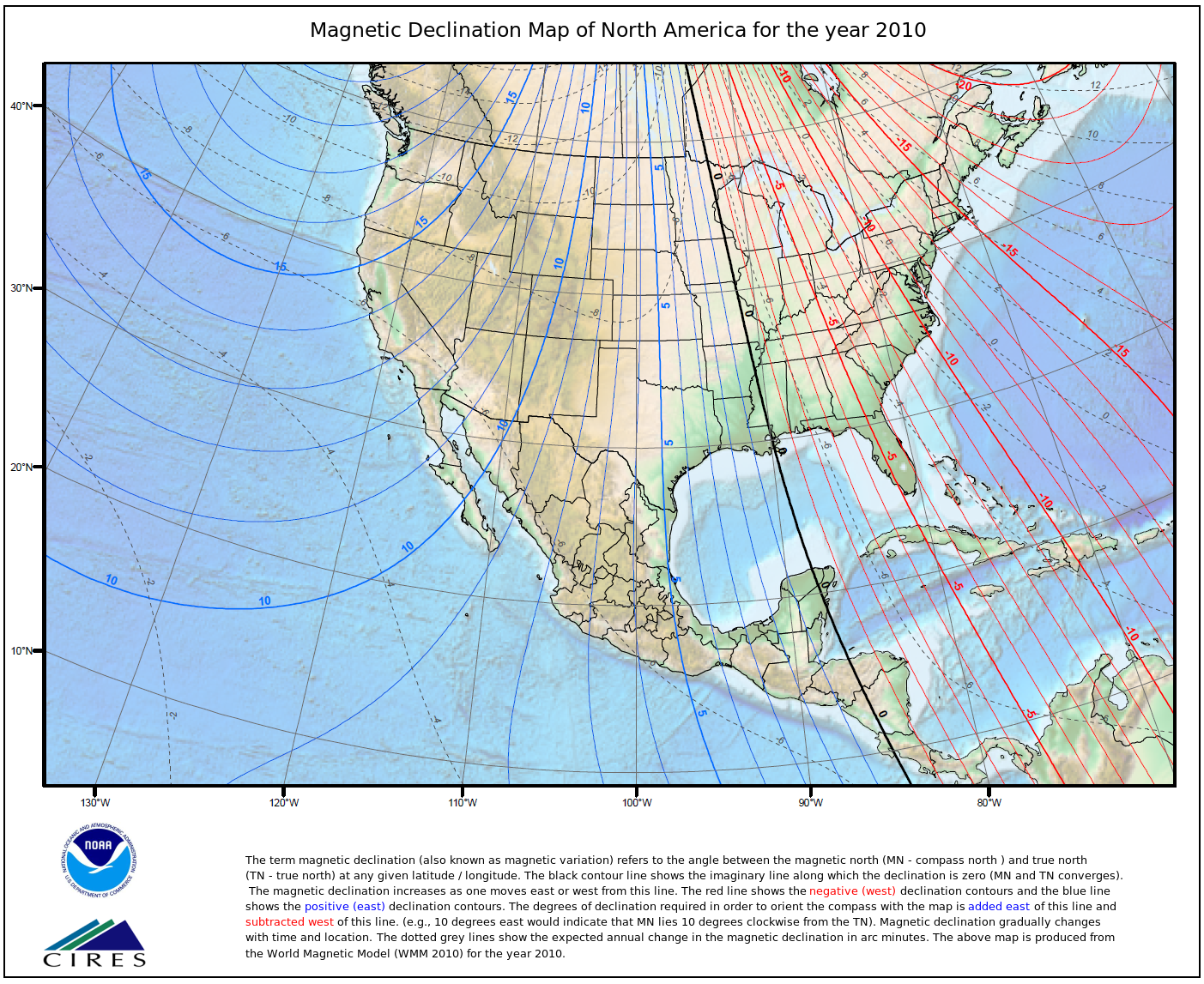
fileDescription: Magnetic Declination map for North America for the year 2010
fileType: PNG
descriptiveKeywords: (MD_Keywords)
keyword: Earth Science > Solid Earth > Geomagnetism > Magnetic Field
keyword: Earth Science > Solid Earth > Geomagnetism > Magnetic Declination
type: (MD_KeywordTypeCode) theme
thesaurusName: (CI_Citation)
title: Global Change Master Directory (GCMD) Science Keywords
date: (CI_Date)
date: 2020-01-09
dateType: (CI_DateTypeCode) publication
edition: 9.1
citedResponsibleParty: (CI_ResponsibleParty)
organisationName: NASA Goddard Space Flight Center, Earth Science Data and Information System
contactInfo: (CI_Contact)
onlineResource: (CI_OnlineResource)
linkage: https://www.earthdata.nasa.gov/learn/find-data/idn/gcmd-keywords
name: Global Change Master Directory (GCMD) Keywords
description: The information provided on this page seeks to define how the GCMD Keywords are structured, used and accessed. It also provides information on how users can participate in the further development of the keywords.
function: (CI_OnLineFunctionCode) information
role: (CI_RoleCode) custodian
descriptiveKeywords: (MD_Keywords)
keyword: Geographic Region > Global
type: (MD_KeywordTypeCode) place
thesaurusName: (CI_Citation)
title: Global Change Master Directory (GCMD) Location Keywords
date: (CI_Date)
date: 2020-01-09
dateType: (CI_DateTypeCode) publication
edition: 9.1
citedResponsibleParty: (CI_ResponsibleParty)
organisationName: NASA Goddard Space Flight Center, Earth Science Data and Information System
contactInfo: (CI_Contact)
onlineResource: (CI_OnlineResource)
linkage: https://www.earthdata.nasa.gov/learn/find-data/idn/gcmd-keywords
name: Global Change Master Directory (GCMD) Keywords
description: The information provided on this page seeks to define how the GCMD Keywords are structured, used and accessed. It also provides information on how users can participate in the further development of the keywords.
function: (CI_OnLineFunctionCode) information
role: (CI_RoleCode) custodian
descriptiveKeywords: (MD_Keywords)
keyword: DOC/NOAA/NESDIS/NCEI > National Centers for Environmental Information, NESDIS, NOAA, U.S. Department of Commerce
keyword: DOC/NOAA/NESDIS/NGDC > National Geophysical Data Center, NESDIS, NOAA, U.S. Department of Commerce
type: (MD_KeywordTypeCode) dataCentre
thesaurusName: (CI_Citation)
title: Global Change Master Directory (GCMD) Data Center Keywords
date: (CI_Date)
date: 2020-01-09
dateType: (CI_DateTypeCode) publication
edition: 9.1
citedResponsibleParty: (CI_ResponsibleParty)
organisationName: NASA Goddard Space Flight Center, Earth Science Data and Information System
contactInfo: (CI_Contact)
onlineResource: (CI_OnlineResource)
linkage: https://www.earthdata.nasa.gov/learn/find-data/idn/gcmd-keywords
name: Global Change Master Directory (GCMD) Keywords
description: The information provided on this page seeks to define how the GCMD Keywords are structured, used and accessed. It also provides information on how users can participate in the further development of the keywords.
function: (CI_OnLineFunctionCode) information
role: (CI_RoleCode) custodian
resourceConstraints: (MD_LegalConstraints)
accessConstraints: (MD_RestrictionCode) otherRestrictions
otherConstraints: Distribution liability: NOAA and NCEI make no warranty, expressed or implied, regarding these data, nor does the fact of distribution constitute such a warranty. NOAA and NCEI cannot assume liability for any damages caused by any errors or omissions in these data. If appropriate, NCEI can only certify that the data it distributes are an authentic copy of the records that were accepted for inclusion in the NCEI archives.
resourceConstraints: (MD_LegalConstraints)
useConstraints: (MD_RestrictionCode) otherRestrictions
otherConstraints: Use liability: NOAA and NCEI cannot provide any warranty as to the accuracy, reliability, or completeness of furnished data. Users assume responsibility to determine the usability of these data. The user is responsible for the results of any application of this data for other than its intended purpose.
resourceConstraints: (MD_Constraints)
useLimitation: Produced by the NOAA National Centers for Environmental Information. Not subject to copyright protection within the United States.
resourceConstraints: (MD_LegalConstraints)
useLimitation: (MD_RestrictionCode) otherRestrictions
otherConstraints: Cite as: NCEI Geomagnetic Modeling Team. 2009: Declination Calculator. NOAA National Centers for Environmental Information. Accessed [date].
spatialRepresentationType: (MD_SpatialRepresentationTypeCode) vector
language: eng; USA
topicCategory: (MD_TopicCategoryCode) geoscientificInformation
extent: (EX_Extent)
description: The IGRF is a global model that extends back to the begining of the 20th Century and is updated every 5 years to include a forcast model for the following 5 years using observations of the Earth's magnetic field over time to interpolate
geographicElement: (EX_GeographicBoundingBox)
westBoundLongitude: -180
eastBoundLongitude: 180
southBoundLatitude: -90
northBoundLatitude: 90
temporalElement: (EX_TemporalExtent)
extent:
TimePeriod:
beginPosition: 1900-01-01
endPosition: 2014-12-31
return to top
contentInfo: (MI_CoverageDescription)
attributeDescription:
RecordType: Individual Value
contentType: (MD_CoverageContentTypeCode) modelResult
dimension: (MD_Band)
descriptor: Declination
maxValue:
Real: 180
minValue:
Real: -180
units:
BaseUnit:
identifier: degree
unitsSystem:
return to top
distributionInfo: (MD_Distribution)
distributor: (MD_Distributor)
distributorContact: (CI_ResponsibleParty)
organisationName: NOAA National Centers for Environmental Information
contactInfo: (CI_Contact)
address: (CI_Address)
electronicMailAddress: ncei.info@noaa.gov
onlineResource: (CI_OnlineResource)
linkage: https://www.ncei.noaa.gov/contact
name: NCEI Contact Information
description: Information for contacts at NCEI.
function: (CI_OnLineFunctionCode) information
role: (CI_RoleCode) distributor
distributionOrderProcess: (MD_StandardOrderProcess)
fees: In most cases, electronic downloads of the data are free. However, fees may apply for custom orders, data certifications, copies of analog materials, and data distribution on physical media.
orderingInstructions: Contact NCEI for other distribution options and instructions.
distributorFormat: (MD_Format)
name: HTML Format
version: 1
specification: The Declination Calculator creates an HTML pop-up window which superimposes a compass rose, indicating the declination, onto the location queried and reports the annual change in declination.
distributorFormat: (MD_Format)
name: XML Format
version: 1
specification: The Declination Calculator creates an XML file which reports the location and date queried as well as the declination and the annual change in declination in decimal minutes per year.
distributorFormat: (MD_Format)
name: CSV Format
version: 1
specification: The Declination Calculator creates an Comma Seperated Variable (CSV) file which reports the location and date queried as well as the declination and the annual change in declination in decimal minutes per year.
distributorFormat: (MD_Format)
name: PDF Format
version: 1
specification: The Declination Calculator creates a Portable Document Format file (PDF) file which reports the location and date queried as well as the declination and the annual change in declination in decimal minutes per year.
distributorTransferOptions: (MD_DigitalTransferOptions)
onLine: (CI_OnlineResource)
linkage: https://www.ncei.noaa.gov/metadata/geoportal/rest/metadata/item/gov.noaa.ngdc.mgg.geophysical_models:Declination_Calculator/html
protocol: HTTPS
name: Metadata Landing Page
function: (CI_OnLineFunctionCode) information
distributorTransferOptions: (MD_DigitalTransferOptions)
onLine: (CI_OnlineResource)
linkage: https://www.ngdc.noaa.gov/geomag/calculators/magcalc.shtml#declination
protocol: HTTPS
name: Magnetic Declination Calculator
function: (CI_OnLineFunctionCode) information
return to top
dataQualityInfo: (DQ_DataQuality)
scope: (DQ_Scope)
level: (MD_ScopeCode) repository
levelDescription: (MD_ScopeDescription)
other: NOAA National Centers for Environmental Information
lineage: (LI_Lineage)
processStep: (LE_ProcessStep)
description: NOAA created the National Centers for Environmental Information (NCEI) by merging NOAA's National Climatic Data Center (NCDC), National Geophysical Data Center (NGDC), and National Oceanographic Data Center (NODC), including the National Coastal Data Development Center (NCDDC), per the Consolidated and Further Continuing Appropriations Act, 2015, Public Law 113-235. NCEI launched publicly on April 22, 2015.
dateTime:
DateTime: 2015-04-22T00:00:00
return to top
dataQualityInfo: (DQ_DataQuality)
scope: (DQ_Scope)
level: (MD_ScopeCode) service
lineage: (LI_Lineage)
processStep: (LE_ProcessStep)
description: User input of area of interest and time for desired data grid into a web interface.
processStep: (LE_ProcessStep)
description: User data is sent via HTTP request to a java servelet hosted on a local server. This checks that all of the necessary information to run the model executable correctly is present and in the correct format.
processStep: (LE_ProcessStep)
description: The server accesses a C executable, in this case the IGRF executable, and inputs the user data and runs the executable to obtain desired output parameters in XML format.
processingInformation: (LE_Processing)
identifier: (MD_Identifier)
code: Processing steps were carried out collectively by the developers of the model. These developers are listed as authors of the associated paper "International Geomagnetic Reference Field: the eleventh generation".
algorithm: (LE_Algorithm)
citation: (CI_Citation)
title: IGRF11 Spherical Harmonic Model.
date: (CI_Date)
date: 2010-10-12
dateType: (CI_DateTypeCode) publication
citedResponsibleParty: (CI_ResponsibleParty)
contactInfo: (CI_Contact)
onlineResource: (CI_OnlineResource)
linkage: https://www.ngdc.noaa.gov/IAGA/vmod/igrf.html
role:
description: Refer to technical report, "International Geomagnetic Reference Field: the eleventh generation", for description of algorithms.
processStep: (LE_ProcessStep)
description: The XML created by the executable is sent back to the server and input into the Java servelet which reformats the output into the format designated by the user at the begining of the process. This reformatted information is returned to the User's webpage.
source: (LI_Source)
description: The IGRF is the product of a collaborative effort between magnetic field modellers and the institutes involved in collecting and disseminating magnetic field data from satellites and from observatories and surveys around the world. The IGRF is a series of mathematical models of the Earth's main field and its annual rate of change (secular variation).
sourceCitation: (CI_Citation)
title: International Geomagnetic Reference Field 11
alternateTitle: IGRF 11
date: (CI_Date)
date: 2010-10-12
dateType: (CI_DateTypeCode) revision
citedResponsibleParty: (CI_ResponsibleParty)
organisationName: International Association of Geomagnetism and Aeronomy (IAGA)
contactInfo: (CI_Contact)
onlineResource: (CI_OnlineResource)
linkage: https://www.ngdc.noaa.gov/IAGA/vmod/igrf.html
name: International Geomagnetic Reference Field
description: The International Association of Geomagnetism and Aeronomy (IAGA) has released the 11th Generation International Geomagnetic Reference Field, which is the latest version of a standard mathematical description of the Earth's main magnetic field that is used widely in studies of the Earth's deep interior, its crust and its ionosphere and magnetosphere.
function: (CI_OnLineFunctionCode) information
role: (CI_RoleCode) resourceProvider
otherCitationDetails: Report on the Reference Field. Equations and coefficients for the eleventh generation. DOI: 10.1111/j.1365-246X.2010.04804.x
return to top
metadataMaintenance: (MD_MaintenanceInformation)
maintenanceAndUpdateFrequency: (MD_MaintenanceFrequencyCode) asNeeded
maintenanceNote: Modified for compliance to NCEI Template v1.2.