Total Sediment Thickness of the World's Oceans & Marginal Seas
- referenceSystemInfo
- identificationInfo
- distributionInfo
- dataQualityInfo
- dataQualityInfo
- metadataMaintenance
(MI_Metadata)
fileIdentifier: gov.noaa.ngdc.mgg.geophysics:G01065
language: eng; USA
characterSet: (MD_CharacterSetCode) utf8
hierarchyLevel: (MD_ScopeCode) dataset
contact: (CI_ResponsibleParty)
individualName: Brian Meyer
organisationName: NOAA National Centers for Environmental Information
contactInfo: (CI_Contact)
phone: (CI_Telephone)
voice: 303-497-6125
address: (CI_Address)
electronicMailAddress: Brian.Meyer@noaa.gov
role: (CI_RoleCode) pointOfContact
dateStamp: 2017-09-25
metadataStandardName: ISO 19115-2 Geographic Information - Metadata - Part 2: Extensions for Imagery and Gridded Data
metadataStandardVersion: ISO 19115-2:2009(E)
return to top
referenceSystemInfo: (MD_ReferenceSystem)
referenceSystemIdentifier: (RS_Identifier)
authority: (CI_Citation)
title: World Geodetic System 1984
alternateTitle: WGS 84
date: (CI_Date)
date: 2007-08-27
dateType: (CI_DateTypeCode) revision
citedResponsibleParty: (CI_ResponsibleParty)
organisationName: (withheld)
contactInfo: (CI_Contact)
onlineResource: (CI_OnlineResource)
linkage: https://epsg.org/crs_4326/WGS-84.html
name: WGS 84
description: GML of World Geodetic System 1984 coordinate reference system.
function: (CI_OnLineFunctionCode) information
role: (CI_RoleCode) resourceProvider
citedResponsibleParty: (CI_ResponsibleParty)
organisationName: European Petroleum Survey Group
contactInfo: (CI_Contact)
onlineResource: (CI_OnlineResource)
linkage: https://epsg.org/home.html
name: European Petroleum Survey Group Geodetic Parameter Registry
description: Registry that accesses the EPSG Geodetic Parameter Dataset, which is a structured dataset of Coordinate Reference Systems and Coordinate Transformations.
function: (CI_OnLineFunctionCode) search
role: (CI_RoleCode) publisher
code: urn:ogc:def:crs:EPSG::4326
return to top
identificationInfo: (MD_DataIdentification)
citation: (CI_Citation)
title: Total Sediment Thickness of the World's Oceans & Marginal Seas
date: (CI_Date)
date: 2003-12-23
dateType: (CI_DateTypeCode) publication
citedResponsibleParty: (CI_ResponsibleParty)
organisationName: NOAA National Centers for Environmental Information
role: (CI_RoleCode) publisher
citedResponsibleParty: (CI_ResponsibleParty)
organisationName: DOC/NOAA/NESDIS/NCEI > National Centers for Environmental Information, NESDIS, NOAA, U.S. Department of Commerce
positionName: User Services
contactInfo: (CI_Contact)
phone: (CI_Telephone)
voice: 303-497-6826
facsimile: 303-497-6513
address: (CI_Address)
deliveryPoint: 325 Broadway
city: Boulder
administrativeArea: CO
postalCode: 80305-3328
country: USA
electronicMailAddress: ngdc.info@noaa.gov
hoursOfService: 8am-5pm, Monday through Friday
role: (CI_RoleCode) publisher
citedResponsibleParty: (CI_ResponsibleParty)
individualName: Barry W. Eakins
organisationName: NOAA National Centers for Environmental Information
positionName: Research Scientist
contactInfo: (CI_Contact)
phone: (CI_Telephone)
voice: 303-497-6505
address: (CI_Address)
deliveryPoint: 325 Broadway, E/GC3
city: Boulder
administrativeArea: Colorado
postalCode: 80305-3328
country: USA
electronicMailAddress: Barry.Eakins@noaa.gov
hoursOfService: 9am-5pm, M-F, Mountain Time
contactInstructions: Contact Marine Geology and Geophysics Division
role: (CI_RoleCode) originator
presentationForm: (CI_PresentationFormCode) mapDigital
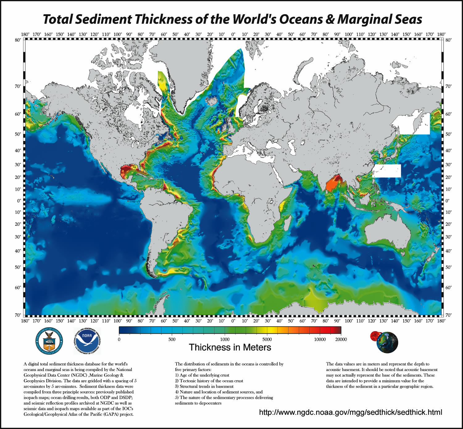
abstract: A digital total-sediment-thickness database for the world's oceans and marginal seas has been compiled by the NOAA National Geophysical Data Center (NGDC). The data were gridded with a grid spacing of 5 arc-minutes by 5 arc-minutes. Sediment-thickness data were compiled from three principle sources: (i) previously published isopach maps including Ludwig and Houtz [1979], Matthias et al. [1988], Divins and Rabinowitz [1990], Hayes and LaBrecque [1991], and Divins [2003]; (ii) ocean drilling results, both from the Ocean Drilling Program (ODP) and the Deep Sea Drilling Project (DSDP); and (iii) seismic reflection profiles archived at NGDC as well as seismic data and isopach maps available as part of the IOC's International Geological-Geophysical Atlas of the Pacific Ocean [Udinstev, 2003].
purpose: To create a global sediment-thickness database for use by researchers and interested public.
status: (MD_ProgressCode) completed
pointOfContact: (CI_ResponsibleParty)
individualName: Barry W. Eakins
organisationName: NOAA National Centers for Environmental Information
positionName: Research Scientist
contactInfo: (CI_Contact)
phone: (CI_Telephone)
voice: 303-497-6505
address: (CI_Address)
deliveryPoint: 325 Broadway, E/GC3
city: Boulder
administrativeArea: Colorado
postalCode: 80305-3328
country: USA
electronicMailAddress: Barry.Eakins@noaa.gov
hoursOfService: 9am-5pm, M-F, Mountain Time
contactInstructions: Contact Marine Geology and Geophysics Division
role: (CI_RoleCode) pointOfContact
resourceMaintenance: (MD_MaintenanceInformation)
maintenanceAndUpdateFrequency: (MD_MaintenanceFrequencyCode) asNeeded
graphicOverview: (MD_BrowseGraphic)
fileName: https://www.ngdc.noaa.gov/mgg/image/sedthick9.jpg
fileDescription: Image of total sediment thickness of the world's oceans and marginal seas.
fileType: JPG
descriptiveKeywords: (MD_Keywords)
keyword: EARTH SCIENCE>OCEANS>Marine Sediments
type: (MD_KeywordTypeCode) theme
thesaurusName: (CI_Citation)
title: Global Change Master Directory (GCMD) Science Keywords
date: (CI_Date)
date: 2020-01-09
dateType: (CI_DateTypeCode) publication
edition: 9.1
citedResponsibleParty: (CI_ResponsibleParty)
organisationName: NASA Goddard Space Flight Center, Earth Science Data and Information System
contactInfo: (CI_Contact)
onlineResource: (CI_OnlineResource)
linkage: https://www.earthdata.nasa.gov/learn/find-data/idn/gcmd-keywords
name: Global Change Master Directory (GCMD) Keywords
description: The information provided on this page seeks to define how the GCMD Keywords are structured, used and accessed. It also provides information on how users can participate in the further development of the keywords.
function: (CI_OnLineFunctionCode) information
role: (CI_RoleCode) custodian
descriptiveKeywords: (MD_Keywords)
keyword: Sediment Thickness
type: (MD_KeywordTypeCode) theme
thesaurusName: (CI_Citation)
title: Uncontrolled Keywords
date: (unknown)
descriptiveKeywords: (MD_Keywords)
keyword: H : 1 km - < 10 km or approximately .01 degree - < .09 degree
keyword: V : 1 meter - < 10 meters
type: (MD_KeywordTypeCode) theme
thesaurusName: (CI_Citation)
title: NASA/GCMD Data Resolution Keywords
date: (unknown)
descriptiveKeywords: (MD_Keywords)
keyword: Ocean>Atlantic Ocean
keyword: Ocean>Indian Ocean
keyword: Ocean>Pacific Ocean
keyword: Ocean>Southern Ocean
keyword: Vertical Location>Sea Floor
type: (MD_KeywordTypeCode) place
thesaurusName: (CI_Citation)
title: Global Change Master Directory (GCMD) Location Keywords
date: (CI_Date)
date: 2020-01-09
dateType: (CI_DateTypeCode) publication
edition: 9.1
citedResponsibleParty: (CI_ResponsibleParty)
organisationName: NASA Goddard Space Flight Center, Earth Science Data and Information System
contactInfo: (CI_Contact)
onlineResource: (CI_OnlineResource)
linkage: https://www.earthdata.nasa.gov/learn/find-data/idn/gcmd-keywords
name: Global Change Master Directory (GCMD) Keywords
description: The information provided on this page seeks to define how the GCMD Keywords are structured, used and accessed. It also provides information on how users can participate in the further development of the keywords.
function: (CI_OnLineFunctionCode) information
role: (CI_RoleCode) custodian
descriptiveKeywords: (MD_Keywords)
keyword: DOC/NOAA/NESDIS/NCEI > National Centers for Environmental Information, NESDIS, NOAA, U.S. Department of Commerce
keyword: DOC/NOAA/NESDIS/NGDC > National Geophysical Data Center, NESDIS, NOAA, U.S. Department of Commerce
type: (MD_KeywordTypeCode) dataCentre
thesaurusName: (CI_Citation)
title: Global Change Master Directory (GCMD) Data Center Keywords
date: (CI_Date)
date: 2020-01-09
dateType: (CI_DateTypeCode) publication
edition: 9.1
citedResponsibleParty: (CI_ResponsibleParty)
organisationName: NASA Goddard Space Flight Center, Earth Science Data and Information System
contactInfo: (CI_Contact)
onlineResource: (CI_OnlineResource)
linkage: https://www.earthdata.nasa.gov/learn/find-data/idn/gcmd-keywords
name: Global Change Master Directory (GCMD) Keywords
description: The information provided on this page seeks to define how the GCMD Keywords are structured, used and accessed. It also provides information on how users can participate in the further development of the keywords.
function: (CI_OnLineFunctionCode) information
role: (CI_RoleCode) custodian
resourceConstraints: (MD_LegalConstraints)
accessConstraints: (MD_RestrictionCode) otherRestrictions
otherConstraints: Distribution liability: NOAA and NCEI make no warranty, expressed or implied, regarding these data, nor does the fact of distribution constitute such a warranty. NOAA and NCEI cannot assume liability for any damages caused by any errors or omissions in these data. If appropriate, NCEI can only certify that the data it distributes are an authentic copy of the records that were accepted for inclusion in the NCEI archives.
resourceConstraints: (MD_LegalConstraints)
useConstraints: (MD_RestrictionCode) otherRestrictions
otherConstraints: Use Constraints: None
resourceConstraints: (MD_LegalConstraints)
accessConstraints: (MD_RestrictionCode) otherRestrictions
otherConstraints: Access Constraints: None
aggregationInfo: (MD_AggregateInformation)
aggregateDataSetName: (CI_Citation)
title: Isopach Map of the Sediments in the Pacific Ocean Basin
date: (CI_Date)
date: 1979-01-01
dateType: (CI_DateTypeCode) publication
citedResponsibleParty: (CI_ResponsibleParty)
organisationName: American Association of Petroleum Geologists
contactInfo: (CI_Contact)
address: (CI_Address)
city: Tulsa
administrativeArea: Oklahoma
role: (CI_RoleCode) publisher
citedResponsibleParty: (CI_ResponsibleParty)
organisationName: Ludwig, W. J.
role: (CI_RoleCode) originator
citedResponsibleParty: (CI_ResponsibleParty)
organisationName: Houtz, R. E.
role: (CI_RoleCode) originator
presentationForm: (CI_PresentationFormCode) mapDigital
associationType: (DS_AssociationTypeCode) crossReference
initiativeType: (DS_InitiativeTypeCode) sciencePaper
aggregationInfo: (MD_AggregateInformation)
aggregateDataSetName: (CI_Citation)
title: Sediment Thickness map of the Indian Ocean
date: (CI_Date)
date: 1988-01-01
dateType: (CI_DateTypeCode) publication
citedResponsibleParty: (CI_ResponsibleParty)
organisationName: American Association of Petroleum Geologists
contactInfo: (CI_Contact)
address: (CI_Address)
city: Tulsa
administrativeArea: Oklahoma
role: (CI_RoleCode) publisher
citedResponsibleParty: (CI_ResponsibleParty)
organisationName: Mathhias, P. K.
role: (CI_RoleCode) originator
citedResponsibleParty: (CI_ResponsibleParty)
organisationName: Rabinowitz, P. D.
role: (CI_RoleCode) originator
citedResponsibleParty: (CI_ResponsibleParty)
organisationName: Dipiazza, N.
role: (CI_RoleCode) originator
presentationForm: (CI_PresentationFormCode) mapDigital
associationType: (DS_AssociationTypeCode) crossReference
initiativeType: (DS_InitiativeTypeCode) sciencePaper
aggregationInfo: (MD_AggregateInformation)
aggregateDataSetName: (CI_Citation)
title: Thickness of Sedimentary Cover for the South Atlantic
date: (CI_Date)
date: 1990-01-01
dateType: (CI_DateTypeCode) publication
citedResponsibleParty: (CI_ResponsibleParty)
organisationName: UNESCO/IOC > Intergovernmental Oceanographic Commission, United Nations Educational, Scientific and Cultural Organization
contactInfo: (CI_Contact)
phone: (CI_Telephone)
voice: +33 1 45 68 10 00
facsimile: +33 1 45 68 58 12
address: (CI_Address)
deliveryPoint: 1 rue Miollis
city: Paris
administrativeArea: Île-de-France
postalCode: 75732 Paris Cedex 15
country: France
role: (CI_RoleCode) publisher
citedResponsibleParty: (CI_ResponsibleParty)
organisationName: Divins, D. L.
role: (CI_RoleCode) originator
citedResponsibleParty: (CI_ResponsibleParty)
organisationName: Rabinowitz, P. D.
role: (CI_RoleCode) originator
presentationForm: (CI_PresentationFormCode) mapDigital
otherCitationDetails: pp. 126-127
associationType: (DS_AssociationTypeCode) crossReference
initiativeType: (DS_InitiativeTypeCode) sciencePaper
aggregationInfo: (MD_AggregateInformation)
aggregateDataSetName: (CI_Citation)
title: Sediment Isopachs: Circum-Antarctic to 30S,
date: (CI_Date)
date: 1991-01-01
dateType: (CI_DateTypeCode) publication
citedResponsibleParty: (CI_ResponsibleParty)
organisationName: American Geophysical Union (AGU)
contactInfo: (CI_Contact)
phone: (CI_Telephone)
voice: (800) 966-2841
address: (CI_Address)
deliveryPoint: 2000 Florida Avenue N.W.
city: Washington
administrativeArea: District of Columbia
postalCode: 20009-1277
country: USA
electronicMailAddress: service@agu.org
role: (CI_RoleCode) publisher
citedResponsibleParty: (CI_ResponsibleParty)
organisationName: Hayes, D. E.
role: (CI_RoleCode) originator
citedResponsibleParty: (CI_ResponsibleParty)
organisationName: LaBrecque, J. L.
role: (CI_RoleCode) originator
presentationForm: (CI_PresentationFormCode) mapDigital
otherCitationDetails: pp. 29-33
associationType: (DS_AssociationTypeCode) crossReference
initiativeType: (DS_InitiativeTypeCode) sciencePaper
aggregationInfo: (MD_AggregateInformation)
aggregateDataSetName: (CI_Citation)
title: Thickness of Sedimentary Cover in the Eastern Pacific Ocean
date: (CI_Date)
date: 2003-01-01
dateType: (CI_DateTypeCode) publication
citedResponsibleParty: (CI_ResponsibleParty)
organisationName: UNESCO/IOC > Intergovernmental Oceanographic Commission, United Nations Educational, Scientific and Cultural Organization
contactInfo: (CI_Contact)
phone: (CI_Telephone)
voice: +33 1 45 68 10 00
facsimile: +33 1 45 68 58 12
address: (CI_Address)
deliveryPoint: 1 rue Miollis
city: Paris
administrativeArea: Île-de-France
postalCode: 75732 Paris Cedex 15
country: France
role: (CI_RoleCode) publisher
citedResponsibleParty: (CI_ResponsibleParty)
organisationName: Divins, D. L.
role: (CI_RoleCode) originator
presentationForm: (CI_PresentationFormCode) mapDigital
otherCitationDetails: pp. 120, 126-127, 130
associationType: (DS_AssociationTypeCode) crossReference
initiativeType: (DS_InitiativeTypeCode) sciencePaper
language: eng; USA
topicCategory: (MD_TopicCategoryCode) geoscientificInformation
extent: (EX_Extent)
geographicElement: (EX_GeographicBoundingBox)
westBoundLongitude: -180.0000
eastBoundLongitude: 180.0000
southBoundLatitude: -70.0000
northBoundLatitude: 79.0000
temporalElement: (EX_TemporalExtent)
extent:
TimePeriod:
beginPosition: 1979-01-01
endPosition: 2003-01-01
return to top
distributionInfo: (MD_Distribution)
distributionFormat: (MD_Format)
name: netCDF
version: 1
specification: binary grid created using GMT (Generic Mapping Tools)
fileDecompressionTechnique: No compression applied
distributionFormat: (MD_Format)
name: ASCII
version: 1
specification: ASCII text versions, both with and without NaNs (not a number)
fileDecompressionTechnique: No compression applied
distributionFormat: (MD_Format)
name: e00
version: 1
specification: ESRI ArcGIS interchange format
fileDecompressionTechnique: WINZIP
distributor: (MD_Distributor)
distributorContact: (CI_ResponsibleParty)
organisationName: DOC/NOAA/NESDIS/NCEI > National Centers for Environmental Information, NESDIS, NOAA, U.S. Department of Commerce
positionName: User Services
contactInfo: (CI_Contact)
phone: (CI_Telephone)
voice: 303-497-6826
facsimile: 303-497-6513
address: (CI_Address)
deliveryPoint: 325 Broadway
city: Boulder
administrativeArea: CO
postalCode: 80305-3328
country: USA
electronicMailAddress: ngdc.info@noaa.gov
hoursOfService: 8am-5pm, Monday through Friday
role: (CI_RoleCode) distributor
distributionOrderProcess: (MD_StandardOrderProcess)
fees: None
transferOptions: (MD_DigitalTransferOptions)
transferSize:
Real: 35600000
onLine: (CI_OnlineResource)
linkage: https://www.ngdc.noaa.gov/mgg/sedthick/data/version1/gmt_netcdf/
transferOptions: (MD_DigitalTransferOptions)
transferSize:
Real: 31000000
onLine: (CI_OnlineResource)
linkage: https://www.ngdc.noaa.gov/mgg/sedthick/data/version1/ascii_nans/
transferOptions: (MD_DigitalTransferOptions)
transferSize:
Real: 9700000
onLine: (CI_OnlineResource)
linkage: https://www.ngdc.noaa.gov/mgg/sedthick/data/version1/arcgis/
return to top
dataQualityInfo: (DQ_DataQuality)
scope: (DQ_Scope)
level: (MD_ScopeCode) repository
levelDescription: (MD_ScopeDescription)
other: NOAA National Centers for Environmental Information
lineage: (LI_Lineage)
processStep: (LE_ProcessStep)
description: NOAA created the National Centers for Environmental Information (NCEI) by merging NOAA's National Climatic Data Center (NCDC), National Geophysical Data Center (NGDC), and National Oceanographic Data Center (NODC), including the National Coastal Data Development Center (NCDDC), per the Consolidated and Further Continuing Appropriations Act, 2015, Public Law 113-235. NCEI launched publicly on April 22, 2015.
dateTime:
DateTime: 2015-04-22T00:00:00
return to top
dataQualityInfo: (DQ_DataQuality)
scope: (DQ_Scope)
level: (MD_ScopeCode) dataset
report: (DQ_CompletenessCommission)
evaluationMethodDescription: NGDC made every effort to obtain all available sediment thickness compilations and data for use in building the global sediment-thickness grid.
result: (unknown)
report: (DQ_ConceptualConsistency)
measureDescription: The distribution of sediments in the oceans is controlled by five primary factors: 1. Age of the underlying crust 2. Tectonic history of the ocean crust 3. Structural trends in basement 4. Nature and location of sediment source, and 5. Nature of the sedimentary processes delivering sediments to depocenters
result: (unknown)
lineage: (LI_Lineage)
processStep: (LE_ProcessStep)
description: The sediment isopach contour maps for the Pacific were digitized by Greg Cole of Los Alamos National Laboratory, for the Indian Ocean by Carol Stein of Northwestern University, and the South Atlantic and Southern Ocean by Dennis Hayes of Lamont-Doherty Earth Observatory.
dateTime:
DateTime: 2000-01-01T00:00:00
processStep: (LE_ProcessStep)
description: The digitized data were then gridded at NGDC using the algorithm for "Gridding with Continuous Curvature Splines in Tension" of Smith and Wessel [1990].
dateTime:
DateTime: 2003-01-01T00:00:00
return to top
metadataMaintenance: (MD_MaintenanceInformation)
maintenanceAndUpdateFrequency: (MD_MaintenanceFrequencyCode) annually
dateOfNextUpdate: 2013-01-18
maintenanceNote: This metadata was automatically generated from the Content Standard for Digital Geospatial Metadata: Extensions for Remote Sensing Metadata standard (version FGDC-STD-012-2002) using the 2012-08-08 version of the FGDC RSE to ISO 19115-2 transform.
maintenanceNote: Translated from FGDC 2012-10-10T10:31:49.827-06:00
maintenanceNote: Last Metadata Review Date: 2017-09-25
maintenanceNote: This record has been automatically modified to include references to NCEI where applicable on 2015-09-01.
contact: (CI_ResponsibleParty)
organisationName: NOAA National Centers for Environmental Information
positionName: Metadata Specialist
role: (CI_RoleCode) editor
contact: (CI_ResponsibleParty)
individualName: Brian Meyer
organisationName: NOAA National Centers for Environmental Information
contactInfo: (CI_Contact)
phone: (CI_Telephone)
voice: 303-497-6125
address: (CI_Address)
electronicMailAddress: Brian.Meyer@noaa.gov
role: (CI_RoleCode) pointOfContact