Volcanic Ash Advisory Database, 1983-2003
- identificationInfo
- contentInfo
- contentInfo
- contentInfo
- contentInfo
- contentInfo
- contentInfo
- distributionInfo
- dataQualityInfo
- dataQualityInfo
- dataQualityInfo
- metadataMaintenance
(MI_Metadata)
fileIdentifier: gov.noaa.ngdc.mgg.hazards:G10073
language: eng; USA
characterSet: (MD_CharacterSetCode) utf8
hierarchyLevel: (MD_ScopeCode) dataset
contact: (CI_ResponsibleParty)
organisationName: NOAA National Centers for Environmental Information
positionName: Hazards Data Manager
contactInfo: (CI_Contact)
address: (CI_Address)
electronicMailAddress: haz.info@noaa.gov
role: (CI_RoleCode) pointOfContact
dateStamp: 2018-07-30
metadataStandardName: ISO 19115-2 Geographic Information - Metadata - Part 2: Extensions for Imagery and Gridded Data
metadataStandardVersion: ISO 19115-2:2009(E)
return to top
identificationInfo: (MD_DataIdentification)
citation: (CI_Citation)
title: Volcanic Ash Advisory Database, 1983-2003
date: (CI_Date)
date: 2006-03-14
dateType: (CI_DateTypeCode) publication
citedResponsibleParty: (CI_ResponsibleParty)
organisationName: NOAA National Centers for Environmental Information
role: (CI_RoleCode) publisher
citedResponsibleParty: (CI_ResponsibleParty)
individualName: Nicolas Arcos
organisationName: DOC/NOAA/NESDIS/NCEI > National Centers for Environmental Information, NESDIS, NOAA, U.S. Department of Commerce
contactInfo: (CI_Contact)
phone: (CI_Telephone)
voice: (303) 497-3158
facsimile: (303) 497-6513
address: (CI_Address)
deliveryPoint: 325 Broadway, Mail Code E/NE42
city: Boulder
administrativeArea: CO
postalCode: 80305-3328
country: USA
electronicMailAddress: haz.info@noaa.gov
role: (CI_RoleCode) pointOfContact
presentationForm: (CI_PresentationFormCode) imageDigital
presentationForm: (CI_PresentationFormCode) tableDigital
abstract: Volcanic ash is a significant hazard to aviation and can also affect global climate patterns. To ensure safe navigation and monitor possible climatic impact, the NOAA Satellite Services Division (SSD) tracks volcanic ash eruptions throughout the world. After an eruption, SSD issues a Volcanic Ash Advisory (VAA) message and a forecast of ash location in the atmosphere from the Volcanic Ash Forecast Transport and Dispersion (VAFTAD) model. The Volcanic Ash Advisory Database contains VAA messages, VAFTAD model output, and substantiating information from 1983 to 2003, that have been scanned into image format. The substantiating information includes surface weather observations, pilot reports, volcanic observatory reports, news media reports, and satellite imagery for each event. This database is static and is no longer being updated by NCEI.
purpose: Provides volcanic ash modelers, climate analysts, and volcanologists with web-access to volcanic ash advisory data from past eruptive events.
credit: Satellite Products and Services Division of the National Environmental Satellite, Data, and Information Service (NESDIS)
status: (MD_ProgressCode) completed
pointOfContact: (CI_ResponsibleParty)
individualName: Nicolas Arcos
organisationName: DOC/NOAA/NESDIS/NCEI > National Centers for Environmental Information, NESDIS, NOAA, U.S. Department of Commerce
contactInfo: (CI_Contact)
phone: (CI_Telephone)
voice: (303) 497-3158
facsimile: (303) 497-6513
address: (CI_Address)
deliveryPoint: 325 Broadway, Mail Code E/NE42
city: Boulder
administrativeArea: CO
postalCode: 80305-3328
country: USA
electronicMailAddress: haz.info@noaa.gov
role: (CI_RoleCode) pointOfContact
resourceMaintenance: (MD_MaintenanceInformation)
maintenanceAndUpdateFrequency: (MD_MaintenanceFrequencyCode) notPlanned
maintenanceNote: There are no plans to update the data in this collection.
graphicOverview: (MD_BrowseGraphic)
fileName: https://www.ngdc.noaa.gov/hazard/icons/volcanoes.jpg
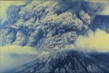
fileDescription: Mt. St. Helens ash cloud
fileType: jpg
descriptiveKeywords: (MD_Keywords)
keyword: Earth Science > Solid Earth > Volcanoes
keyword: Earth Science > Solid Earth > Volcanoes > Eruption Dynamics
keyword: Earth Science > Solid Earth > Volcanoes > Volcanic Ash/Dust
type: (MD_KeywordTypeCode) theme
thesaurusName: (CI_Citation)
title: Global Change Master Directory (GCMD) Science Keywords
date: (CI_Date)
date: 2020-01-09
dateType: (CI_DateTypeCode) publication
edition: 9.1
citedResponsibleParty: (CI_ResponsibleParty)
organisationName: NASA Goddard Space Flight Center, Earth Science Data and Information System
contactInfo: (CI_Contact)
onlineResource: (CI_OnlineResource)
linkage: https://www.earthdata.nasa.gov/learn/find-data/idn/gcmd-keywords
name: Global Change Master Directory (GCMD) Keywords
description: The information provided on this page seeks to define how the GCMD Keywords are structured, used and accessed. It also provides information on how users can participate in the further development of the keywords.
function: (CI_OnLineFunctionCode) information
role: (CI_RoleCode) custodian
descriptiveKeywords: (MD_Keywords)
keyword: ICSU-WDS > International Council for Science - World Data System
type: (MD_KeywordTypeCode) project
thesaurusName: (CI_Citation)
title: Global Change Master Directory (GCMD) Project Keywords
date: (CI_Date)
date: 2020-01-09
dateType: (CI_DateTypeCode) publication
edition: 9.1
citedResponsibleParty: (CI_ResponsibleParty)
organisationName: NASA Goddard Space Flight Center, Earth Science Data and Information System
contactInfo: (CI_Contact)
onlineResource: (CI_OnlineResource)
linkage: https://www.earthdata.nasa.gov/learn/find-data/idn/gcmd-keywords
name: Global Change Master Directory (GCMD) Keywords
description: The information provided on this page seeks to define how the GCMD Keywords are structured, used and accessed. It also provides information on how users can participate in the further development of the keywords.
function: (CI_OnLineFunctionCode) information
role: (CI_RoleCode) custodian
descriptiveKeywords: (MD_Keywords)
keyword: Global
type: (MD_KeywordTypeCode) place
thesaurusName: (CI_Citation)
title: Global Change Master Directory (GCMD) Location Keywords
date: (CI_Date)
date: 2020-01-09
dateType: (CI_DateTypeCode) publication
edition: 9.1
citedResponsibleParty: (CI_ResponsibleParty)
organisationName: NASA Goddard Space Flight Center, Earth Science Data and Information System
contactInfo: (CI_Contact)
onlineResource: (CI_OnlineResource)
linkage: https://www.earthdata.nasa.gov/learn/find-data/idn/gcmd-keywords
name: Global Change Master Directory (GCMD) Keywords
description: The information provided on this page seeks to define how the GCMD Keywords are structured, used and accessed. It also provides information on how users can participate in the further development of the keywords.
function: (CI_OnLineFunctionCode) information
role: (CI_RoleCode) custodian
descriptiveKeywords: (MD_Keywords)
keyword: DOC/NOAA/NESDIS/NCEI > National Centers for Environmental Information, NESDIS, NOAA, U.S. Department of Commerce
keyword: DOC/NOAA/NESDIS/NGDC > National Geophysical Data Center, NESDIS, NOAA, U.S. Department of Commerce
type: (MD_KeywordTypeCode) dataCentre
thesaurusName: (CI_Citation)
title: Global Change Master Directory (GCMD) Data Center Keywords
date: (CI_Date)
date: 2020-01-09
dateType: (CI_DateTypeCode) publication
edition: 9.1
citedResponsibleParty: (CI_ResponsibleParty)
organisationName: NASA Goddard Space Flight Center, Earth Science Data and Information System
contactInfo: (CI_Contact)
onlineResource: (CI_OnlineResource)
linkage: https://www.earthdata.nasa.gov/learn/find-data/idn/gcmd-keywords
name: Global Change Master Directory (GCMD) Keywords
description: The information provided on this page seeks to define how the GCMD Keywords are structured, used and accessed. It also provides information on how users can participate in the further development of the keywords.
function: (CI_OnLineFunctionCode) information
role: (CI_RoleCode) custodian
resourceConstraints: (MD_Constraints)
useLimitation: Produced by the NOAA National Centers for Environmental Information. Not subject to copyright protection within the United States.
resourceConstraints: (MD_LegalConstraints)
accessConstraints: (MD_RestrictionCode) otherRestrictions
otherConstraints: Distribution liability: NOAA and NCEI make no warranty, expressed or implied, regarding these data, nor does the fact of distribution constitute such a warranty. NOAA and NCEI cannot assume liability for any damages caused by any errors or omissions in these data. If appropriate, NCEI can only certify that the data it distributes are an authentic copy of the records that were accepted for inclusion in the NCEI archives.
language: eng; USA
topicCategory: (MD_TopicCategoryCode) climatologyMeteorologyAtmosphere
extent: (EX_Extent)
geographicElement: (EX_GeographicBoundingBox)
westBoundLongitude: -179
eastBoundLongitude: 179
southBoundLatitude: -79
northBoundLatitude: 89
temporalElement: (EX_TemporalExtent)
extent:
TimePeriod:
beginPosition: 1983-07-18
endPosition: 2003-02-23
return to top
contentInfo: (MI_CoverageDescription)
attributeDescription:
RecordType: Volcano Name
contentType: (MD_CoverageContentTypeCode) referenceInformation
return to top
contentInfo: (MI_CoverageDescription)
attributeDescription:
RecordType: Location
contentType: (MD_CoverageContentTypeCode) coordinate
dimension: (MD_Band)
sequenceIdentifier:
MemberName:
aName: Latitude
attributeType: (unknown)
descriptor: Distance measured north or south from the equator. Distance north is positive, distance south is negative.
maxValue:
Real: 90.00000
minValue:
Real: -90.00000
units:
UnitDefinition:
identifier: decimal degrees
name: decimal degrees
dimension: (MD_Band)
sequenceIdentifier:
MemberName:
aName: Longitude
attributeType: (unknown)
descriptor: Longitude is measured from the Prime Meridian (which is the north/south line that runs through Greenwich, England), values measured east are positive and values measured west are negative.
maxValue:
Real: 180.00000
minValue:
Real: -180.00000
units:
UnitDefinition:
identifier: decimal degrees
name: decimal degrees
dimension: (MD_Band)
sequenceIdentifier:
MemberName:
aName: Region
attributeType: (unknown)
descriptor: The global region in which the volcano is located.
return to top
contentInfo: (MI_CoverageDescription)
attributeDescription:
RecordType: Date of Volcanic Ash Advisory
contentType: (MD_CoverageContentTypeCode) physicalMeasurement
return to top
contentInfo: (MI_CoverageDescription)
attributeDescription:
RecordType: Type of Information
contentType: (MD_CoverageContentTypeCode) thematicClassification
rangeElementDescription: (MI_RangeElementDescription)
name: Type of Information
definition: The type of information, whether it be an advisory, model output, or substantiating information.
rangeElement:
Record: Substantiating Information
rangeElement:
Record: Volcanic Ash Advisories and VAFTAD Output
return to top
contentInfo: (MI_CoverageDescription)
attributeDescription:
RecordType: Type of Image
contentType: (MD_CoverageContentTypeCode) thematicClassification
return to top
contentInfo: (MI_CoverageDescription)
attributeDescription:
RecordType: Filename
contentType: (MD_CoverageContentTypeCode) referenceInformation
return to top
distributionInfo: (MD_Distribution)
distributionFormat: (MD_Format)
name: jpeg
version: (unknown)
distributor: (MD_Distributor)
distributorContact: (CI_ResponsibleParty)
organisationName: NOAA National Centers for Environmental Information
positionName: Hazards Data Manager
contactInfo: (CI_Contact)
address: (CI_Address)
electronicMailAddress: haz.info@noaa.gov
role: (CI_RoleCode) pointOfContact
distributionOrderProcess: (MD_StandardOrderProcess)
fees: Free on the web
transferOptions: (MD_DigitalTransferOptions)
onLine: (CI_OnlineResource)
linkage: https://www.ngdc.noaa.gov/nndc/servlet/ShowDatasets?dataset=101597&search_look=39&display_look=39
protocol: http
name: Volcanic Ash Advisory Database Inventory Search
description: Use this form to search the inventory of the volcanic ash advisory database. The Volcanic Ash Advisory Database contains VAA messages, VAFTAD model output, and substantiating information from 1983 to 2003, that have been scanned into image format. This database is static and is no longer being updated by NCEI.
function: (CI_OnLineFunctionCode) search
return to top
dataQualityInfo: (DQ_DataQuality)
scope: (DQ_Scope)
level: (MD_ScopeCode) dataset
lineage: (LI_Lineage)
statement: This database was started in 2004 when Grace Swanson of the NOAA/NESDIS/Satellite Analysis Branch provided twenty years (1983 to 2003) of files containing Volcanic Ash Advisory (VAA) messages issued by the Washington Volcanic Ash Advisory Center (VAAC), Volcanic Ash Forecast Transport and Dispersion (VAFTAD) model output, and substantiating information to the National Geophysical Data Center (NGDC) for archive and distribution. The documents were scanned into image format. The scanning effort was funded through the NOAA Earth Systems Data and Information Management (ESDIM) funding program. The purpose of the project was to provide examples to meteorological offices in other countries of the volcanic ash advisory decision-making process.
processStep: (LI_ProcessStep)
description: The database was created in 2004 from twenty years of files containing Volcanic Ash Advisory (VAA) messages issued by the Washington Volcanic Ash Advisory Center (VAAC), Volcanic Ash Forecast Transport and Dispersion (VAFTAD) model output, and substantiating information to the National Geophysical Data Center (NGDC) for archive and distribution.
processor: (CI_ResponsibleParty)
individualName: Natural Hazards Data Manager
organisationName: DOC/NOAA/NESDIS/NCEI > National Centers for Environmental Information, NESDIS, NOAA, U.S. Department of Commerce
role: (CI_RoleCode) custodian
source: (LI_Source)
description: This database was started in 2004 when Grace Swanson of the NOAA/NESDIS/Satellite Analysis Branch provided twenty years (1983 to 2003) of files containing Volcanic Ash Advisory (VAA) messages issued by the Washington Volcanic Ash Advisory Center (VAAC), Volcanic Ash Forecast Transport and Dispersion (VAFTAD) model output, and substantiating information to the National Geophysical Data Center (NGDC) for archive and distribution.
return to top
dataQualityInfo: (DQ_DataQuality)
scope: (DQ_Scope)
level: (MD_ScopeCode) dataset
report: (DQ_CompletenessCommission)
evaluationMethodDescription: The database is an accurate and complete representation of the decision-making process and algorithms that were used by the Washington Volcanic Ash Advisory Center (VAAC) during this time period.
result: (unknown)
return to top
dataQualityInfo: (DQ_DataQuality)
scope: (DQ_Scope)
level: (MD_ScopeCode) repository
levelDescription: (MD_ScopeDescription)
other: NOAA National Centers for Environmental Information
lineage: (LI_Lineage)
processStep: (LE_ProcessStep)
description: NOAA created the National Centers for Environmental Information (NCEI) by merging NOAA's National Climatic Data Center (NCDC), National Geophysical Data Center (NGDC), and National Oceanographic Data Center (NODC), including the National Coastal Data Development Center (NCDDC), per the Consolidated and Further Continuing Appropriations Act, 2015, Public Law 113-235. NCEI launched publicly on April 22, 2015.
dateTime:
DateTime: 2015-04-22T00:00:00
return to top
metadataMaintenance: (MD_MaintenanceInformation)
maintenanceAndUpdateFrequency: (MD_MaintenanceFrequencyCode) unknown
maintenanceNote: This record was automatically modified on 2015-10-01 to include references to NCEI where applicable.
contact: (CI_ResponsibleParty)
organisationName: NOAA National Centers for Environmental Information
positionName: Metadata Specialist
role: (CI_RoleCode) editor