NCEI/WDS Global Significant Volcanic Eruptions Database, 4360 BC to Present
- identificationInfo
- contentInfo
- contentInfo
- contentInfo
- contentInfo
- contentInfo
- contentInfo
- distributionInfo
- dataQualityInfo
- dataQualityInfo
- dataQualityInfo
- metadataMaintenance
(MI_Metadata)
fileIdentifier: gov.noaa.ngdc.mgg.hazards:G10147
language: eng; USA
characterSet: (MD_CharacterSetCode) utf8
hierarchyLevel: (MD_ScopeCode) dataset
contact: (CI_ResponsibleParty)
organisationName: NOAA National Centers for Environmental Information
positionName: Hazards Data Manager
contactInfo: (CI_Contact)
address: (CI_Address)
electronicMailAddress: haz.info@noaa.gov
role: (CI_RoleCode) pointOfContact
dateStamp: 2021-07-08
metadataStandardName: ISO 19115-2 Geographic Information - Metadata - Part 2: Extensions for Imagery and Gridded Data
metadataStandardVersion: ISO 19115-2:2009(E)
return to top
identificationInfo: (MD_DataIdentification)
citation: (CI_Citation)
title: NCEI/WDS Global Significant Volcanic Eruptions Database, 4360 BC to Present
date: (CI_Date)
date: 2001-03-23
dateType: (CI_DateTypeCode) publication
identifier: (MD_Identifier)
code:
Anchor: DOI doi:10.7289/V5JW8BSH
citedResponsibleParty: (CI_ResponsibleParty)
organisationName: NOAA National Centers for Environmental Information
role: (CI_RoleCode) publisher
citedResponsibleParty: (CI_ResponsibleParty)
organisationName: National Geophysical Data Center / World Data Service (NGDC/WDS)
role: (CI_RoleCode) originator
citedResponsibleParty: (CI_ResponsibleParty)
individualName: Nicolas Arcos
organisationName: DOC/NOAA/NESDIS/NCEI > National Centers for Environmental Information, NESDIS, NOAA, U.S. Department of Commerce
contactInfo: (CI_Contact)
phone: (CI_Telephone)
voice: (303) 497-3158
facsimile: (303) 497-6513
address: (CI_Address)
deliveryPoint: 325 Broadway, Mail Code E/NE42
city: Boulder
administrativeArea: CO
postalCode: 80305-3328
country: USA
electronicMailAddress: haz.info@noaa.gov
role: (CI_RoleCode) pointOfContact
presentationForm: (CI_PresentationFormCode) mapDigital
presentationForm: (CI_PresentationFormCode) tableDigital
abstract: The Significant Volcanic Eruptions Database is a global listing of over 600 eruptions from 4360 BC to the present. A significant eruption is classified as one that meets at least one of the following criteria: caused fatalities, caused moderate damage (approximately $1 million or more), Volcanic Explosivity Index (VEI) of 6 or greater, generated a tsunami, or was associated with a significant earthquake. The database provides information on the latitude, longitude, elevation, type of volcano, last known eruption, VEI index, and socio-economic data such as the total number of casualties, injuries, houses destroyed, and houses damaged, and $ dollage damage estimates. References, political geography, and additional comments are also provided for each eruption. If the eruption was associated with a tsunami or significant earthquake, it is flagged and linked to the related database. For a complete list of current and past activity for all volcanoes on the planet active during the last 10,000 years, please see Smithsonian Institution's Global Volcanism Program (GVP).
purpose: These data are necessary for volcanic hazard assessments and mitigation efforts.
status: (MD_ProgressCode) onGoing
pointOfContact: (CI_ResponsibleParty)
individualName: Nicolas Arcos
organisationName: DOC/NOAA/NESDIS/NCEI > National Centers for Environmental Information, NESDIS, NOAA, U.S. Department of Commerce
contactInfo: (CI_Contact)
phone: (CI_Telephone)
voice: (303) 497-3158
facsimile: (303) 497-6513
address: (CI_Address)
deliveryPoint: 325 Broadway, Mail Code E/NE42
city: Boulder
administrativeArea: CO
postalCode: 80305-3328
country: USA
electronicMailAddress: haz.info@noaa.gov
role: (CI_RoleCode) pointOfContact
resourceMaintenance: (MD_MaintenanceInformation)
maintenanceAndUpdateFrequency: (MD_MaintenanceFrequencyCode) asNeeded
graphicOverview: (MD_BrowseGraphic)
fileName: https://www.ngdc.noaa.gov/hazard/icons/73900106.jpg
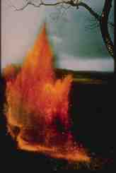
fileDescription: A lava fountain from the 1959 eruption of Kilauea Iki, Hawaii.
fileType: jpg
descriptiveKeywords: (MD_Keywords)
keyword: Earth Science > Solid Earth > Volcanoes > Eruption Dynamics
keyword: Earth Science > Solid Earth > Volcanoes > Lava
keyword: Earth Science > Solid Earth > Volcanoes > Magma
keyword: Earth Science > Solid Earth > Volcanoes > Pyroclastics
keyword: Earth Science > Solid Earth > Volcanoes > Volcanic Ash/Dust
type: (MD_KeywordTypeCode) theme
thesaurusName: (CI_Citation)
title: Global Change Master Directory (GCMD) Science Keywords
date: (CI_Date)
date: 2020-01-09
dateType: (CI_DateTypeCode) publication
edition: 9.1
citedResponsibleParty: (CI_ResponsibleParty)
organisationName: NASA Goddard Space Flight Center, Earth Science Data and Information System
contactInfo: (CI_Contact)
onlineResource: (CI_OnlineResource)
linkage: https://www.earthdata.nasa.gov/learn/find-data/idn/gcmd-keywords
name: Global Change Master Directory (GCMD) Keywords
description: The information provided on this page seeks to define how the GCMD Keywords are structured, used and accessed. It also provides information on how users can participate in the further development of the keywords.
function: (CI_OnLineFunctionCode) information
role: (CI_RoleCode) custodian
descriptiveKeywords: (MD_Keywords)
keyword: Visual Observations
type: (MD_KeywordTypeCode) instrument
thesaurusName: (CI_Citation)
title: Global Change Master Directory (GCMD) Instrument Keywords
date: (CI_Date)
date: 2020-01-09
dateType: (CI_DateTypeCode) publication
edition: 9.1
citedResponsibleParty: (CI_ResponsibleParty)
organisationName: NASA Goddard Space Flight Center, Earth Science Data and Information System
contactInfo: (CI_Contact)
onlineResource: (CI_OnlineResource)
linkage: https://www.earthdata.nasa.gov/learn/find-data/idn/gcmd-keywords
name: Global Change Master Directory (GCMD) Keywords
description: The information provided on this page seeks to define how the GCMD Keywords are structured, used and accessed. It also provides information on how users can participate in the further development of the keywords.
function: (CI_OnLineFunctionCode) information
role: (CI_RoleCode) custodian
descriptiveKeywords: (MD_Keywords)
keyword: ICSU-WDS > International Council for Science - World Data System
type: (MD_KeywordTypeCode) project
thesaurusName: (CI_Citation)
title: Global Change Master Directory (GCMD) Project Keywords
date: (CI_Date)
date: 2020-01-09
dateType: (CI_DateTypeCode) publication
edition: 9.1
citedResponsibleParty: (CI_ResponsibleParty)
organisationName: NASA Goddard Space Flight Center, Earth Science Data and Information System
contactInfo: (CI_Contact)
onlineResource: (CI_OnlineResource)
linkage: https://www.earthdata.nasa.gov/learn/find-data/idn/gcmd-keywords
name: Global Change Master Directory (GCMD) Keywords
description: The information provided on this page seeks to define how the GCMD Keywords are structured, used and accessed. It also provides information on how users can participate in the further development of the keywords.
function: (CI_OnLineFunctionCode) information
role: (CI_RoleCode) custodian
descriptiveKeywords: (MD_Keywords)
keyword: Global
type: (MD_KeywordTypeCode) place
thesaurusName: (CI_Citation)
title: Global Change Master Directory (GCMD) Location Keywords
date: (CI_Date)
date: 2020-01-09
dateType: (CI_DateTypeCode) publication
edition: 9.1
citedResponsibleParty: (CI_ResponsibleParty)
organisationName: NASA Goddard Space Flight Center, Earth Science Data and Information System
contactInfo: (CI_Contact)
onlineResource: (CI_OnlineResource)
linkage: https://www.earthdata.nasa.gov/learn/find-data/idn/gcmd-keywords
name: Global Change Master Directory (GCMD) Keywords
description: The information provided on this page seeks to define how the GCMD Keywords are structured, used and accessed. It also provides information on how users can participate in the further development of the keywords.
function: (CI_OnLineFunctionCode) information
role: (CI_RoleCode) custodian
descriptiveKeywords: (MD_Keywords)
keyword: DOC/NOAA/NESDIS/NCEI > National Centers for Environmental Information, NESDIS, NOAA, U.S. Department of Commerce
keyword: DOC/NOAA/NESDIS/NGDC > National Geophysical Data Center, NESDIS, NOAA, U.S. Department of Commerce
type: (MD_KeywordTypeCode) dataCentre
thesaurusName: (CI_Citation)
title: Global Change Master Directory (GCMD) Data Center Keywords
date: (CI_Date)
date: 2020-01-09
dateType: (CI_DateTypeCode) publication
edition: 9.1
citedResponsibleParty: (CI_ResponsibleParty)
organisationName: NASA Goddard Space Flight Center, Earth Science Data and Information System
contactInfo: (CI_Contact)
onlineResource: (CI_OnlineResource)
linkage: https://www.earthdata.nasa.gov/learn/find-data/idn/gcmd-keywords
name: Global Change Master Directory (GCMD) Keywords
description: The information provided on this page seeks to define how the GCMD Keywords are structured, used and accessed. It also provides information on how users can participate in the further development of the keywords.
function: (CI_OnLineFunctionCode) information
role: (CI_RoleCode) custodian
resourceConstraints: (MD_LegalConstraints)
useLimitation: (MD_RestrictionCode) otherRestrictions
otherConstraints: Cite as: National Geophysical Data Center / World Data Service (NGDC/WDS): NCEI/WDS Global Significant Volcanic Eruptions Database. NOAA National Centers for Environmental Information. doi:10.7289/V5JW8BSH [access date]
resourceConstraints: (MD_LegalConstraints)
accessConstraints: (MD_RestrictionCode) otherRestrictions
otherConstraints: Access to this dataset is unrestricted.
resourceConstraints: (MD_LegalConstraints)
useConstraints: (MD_RestrictionCode) otherRestrictions
otherConstraints: While every effort has been made to ensure that these data are accurate and reliable within the limits of the current state of the art, NOAA cannot assume liability for any damages caused by any errors or omissions in the data, nor as a result of the failure of the data to function on a particular system. NOAA makes no warranty, expressed or implied, nor does the fact of distribution constitute such a warranty.
aggregationInfo: (MD_AggregateInformation)
aggregateDataSetName: (CI_Citation)
title: NCEI/WDS Global Historical Tsunami Database, 2100 BC to Present
date: (CI_Date)
date: 1974-01-01
dateType: (CI_DateTypeCode) publication
identifier: (MD_Identifier)
code:
Anchor: DOI doi:10.7289/V5PN93H7
associationType: (DS_AssociationTypeCode) partOfSeamlessDatabase
initiativeType: (DS_InitiativeTypeCode) collection
aggregationInfo: (MD_AggregateInformation)
aggregateDataSetName: (CI_Citation)
title: NCEI/WDS Global Significant Earthquake Database, 2150 BC to Present
date: (CI_Date)
date: 1972-01-01
dateType: (CI_DateTypeCode) publication
identifier: (MD_Identifier)
code:
Anchor: DOI doi:10.7289/V5TD9V7K
associationType: (DS_AssociationTypeCode) partOfSeamlessDatabase
initiativeType: (DS_InitiativeTypeCode) collection
aggregationInfo: (MD_AggregateInformation)
aggregateDataSetName: (CI_Citation)
title: Global Volcano Locations Database
date: (CI_Date)
date: 2002-01-01
dateType: (CI_DateTypeCode) publication
associationType: (DS_AssociationTypeCode) partOfSeamlessDatabase
initiativeType: (DS_InitiativeTypeCode) collection
aggregationInfo: (MD_AggregateInformation)
aggregateDataSetName: (CI_Citation)
title: The volcanic explosivity index (VEI): an estimate of explosive magnitude for historical volcanism
date: (CI_Date)
date: 1982-01-01
dateType: (CI_DateTypeCode) publication
citedResponsibleParty: (CI_ResponsibleParty)
organisationName: Newhall, C.G.
role: (CI_RoleCode) author
citedResponsibleParty: (CI_ResponsibleParty)
organisationName: Self, S.
role: (CI_RoleCode) author
series: (CI_Series)
name: Journal of Geophysical Research: Oceans and Atmospheres
issueIdentification: 87
otherCitationDetails: pp. 1231-1238
associationType: (DS_AssociationTypeCode) crossReference
initiativeType: (DS_InitiativeTypeCode) sciencePaper
aggregationInfo: (MD_AggregateInformation)
aggregateDataSetName: (CI_Citation)
title: Volcanoes of the World, 2nd edition
date: (CI_Date)
date: 1994-01-01
dateType: (CI_DateTypeCode) publication
citedResponsibleParty: (CI_ResponsibleParty)
organisationName: Simkin, T.
role: (CI_RoleCode) author
citedResponsibleParty: (CI_ResponsibleParty)
organisationName: Siebert, L.
role: (CI_RoleCode) author
series: (CI_Series)
name: Geoscience Press in association with the Smithsonian Institute Global Volcanism Program
otherCitationDetails: 368 p.
associationType: (DS_AssociationTypeCode) crossReference
initiativeType: (DS_InitiativeTypeCode) sciencePaper
language: eng; USA
topicCategory: (MD_TopicCategoryCode) oceans
topicCategory: (MD_TopicCategoryCode) geoscientificInformation
extent: (EX_Extent)
geographicElement: (EX_GeographicBoundingBox)
westBoundLongitude: -180
eastBoundLongitude: 180
southBoundLatitude: -63
northBoundLatitude: 71
temporalElement: (EX_TemporalExtent)
extent:
TimePeriod:
beginPosition: -4360
endPosition:
return to top
contentInfo: (MI_CoverageDescription)
attributeDescription:
RecordType: Volcano Name
contentType: (MD_CoverageContentTypeCode) referenceInformation
return to top
contentInfo: (MI_CoverageDescription)
attributeDescription:
RecordType: Event Date
contentType: (MD_CoverageContentTypeCode) physicalMeasurement
return to top
contentInfo: (MI_CoverageDescription)
attributeDescription:
RecordType: Location
contentType: (MD_CoverageContentTypeCode) coordinate
dimension: (MD_Band)
sequenceIdentifier:
MemberName:
aName: Latitude
attributeType: (unknown)
descriptor: Distance measured north or south from the equator. Distance north is positive, distance south is negative.
maxValue:
Real: 90.00000
minValue:
Real: -90.00000
units:
UnitDefinition:
identifier: decimal degrees
name: decimal degrees
dimension: (MD_Band)
sequenceIdentifier:
MemberName:
aName: Longitude
attributeType: (unknown)
descriptor: Longitude is measured from the Prime Meridian (which is the north/south line that runs through Greenwich, England), values measured east are positive and values measured west are negative.
maxValue:
Real: 180.00000
minValue:
Real: -180.00000
units:
UnitDefinition:
identifier: decimal degrees
name: decimal degrees
dimension: (MD_Band)
sequenceIdentifier:
MemberName:
aName: Elevation
attributeType: (unknown)
descriptor: The elevation of the volcano above global mean sea level. Negative elevation indicates a submarine volcano.
maxValue:
Real: 6887
minValue:
Real: -6000
units:
UnitDefinition:
identifier: meters
name: meters
dimension: (MD_Band)
sequenceIdentifier:
MemberName:
aName: Country
attributeType: (unknown)
descriptor: The country in which the volcano is located.
dimension: (MD_Band)
sequenceIdentifier:
MemberName:
aName: Region
attributeType: (unknown)
descriptor: The global region in which the volcano is located.
return to top
contentInfo: (MI_CoverageDescription)
attributeDescription:
RecordType: Volcano Type
contentType: (MD_CoverageContentTypeCode) thematicClassification
dimension: (MD_Band)
sequenceIdentifier:
MemberName:
aName: Type
attributeType: (unknown)
descriptor: The volcano type as listed by the Smithsonian Institution, Global Volcanism Program. For more information please visit the Global Volcanism Program's volcano types and processes gallery.
return to top
contentInfo: (MI_CoverageDescription)
attributeDescription:
RecordType: Eruption Characteristics
contentType: (MD_CoverageContentTypeCode) physicalMeasurement
dimension: (MD_Band)
sequenceIdentifier:
MemberName:
aName: Associated Hazard
attributeType: (unknown)
descriptor: Whether or not the volcanic eruption caused a tsunami and/or occurred in conjunction with a significant earthquake.
rangeElementDescription: (MI_RangeElementDescription)
name: Volcano Explosivity Index (VEI)
definition: A widely used classification scheme to describe the size of explosive eruptions. It is based principally on the erupted mass or volume of a deposit (Newhall and Self, 1982). Historic eruptions that were definitely explosive, but carry no other descriptive information are assigned a default VEI of 2.
rangeElement:
Record: 0 = General Description: Non-explosive, Cloud-Column Height: <0.1 km, Volume: 10^4 m^3, Qualitative Description: Gentle, Classification: Hawaiian, Recurrence: Daily, Example: Kilauea
rangeElement:
Record: 1 = General Description: Small, Cloud-Column Height: 0.1-1 km, Volume: 10^6 m^3, Qualitative Description: Effusive, Classification: Haw/Strombolian, Recurrence: Daily, Example: Stromboli
rangeElement:
Record: 2 = General Description: Moderate, Cloud-Column Height: 1-5 km, Volume: 10^7 m^3, Qualitative Description: Explosive, Classification: Strom/Vulcanian, Recurrence: Weekly, Example: Galeras, 1992
rangeElement:
Record: 3 = General Description: Moderate-Large, Cloud-Column Height: 3-15 km, Volume: 10^8 m^3, Qualitative Description: Explosive, Classification: Vulcanian, Recurrence: Yearly, Example: Ruiz, 1985
rangeElement:
Record: 4 = General Description: Large, Cloud-Column Height: 10-25 km, Volume: 10^9 m^3, Qualitative Description: Explosive, Classification: Vulc/Plinian, Recurrence: 10's of years, Example: Galunggung, 1982
rangeElement:
Record: 5 = General Description: Very Large, Cloud-Column Height: >25 km, Volume: 10^10 m^3, Qualitative Description: Cataclysmic, Classification: Plinian, Recurrence: 100's of years, Example: St. Helens, 1981
rangeElement:
Record: 6 = Cloud-Column Height: >25 km, Volume: 10^11 m^3, Qualitative Description: Paroxysmal, Classification: Plin/Ultra-Plinian, Recurrence: 100's of years, Example: Krakatau, 1883
rangeElement:
Record: 7 = Cloud-Column Height: >25 km, Volume: 10^12 m^3, Qualitative Description: Colossal, Classification: Ultra-Plinian, Recurrence: 1000's of years, Example: Tambora, 1815
rangeElement:
Record: 8 = Cloud-Column Height: >25 km, Volume: 10^12 m^3, Qualitative Description: Colossal, Classification: Ultra-Plinian, Recurrence: 10,000's of years, Example: Yellowstone, 2 Ma
rangeElementDescription: (MI_RangeElementDescription)
name: Agent
definition: The agent that caused the fatalities for an eruption. Adapted from Simkin and Siebert, 1994.
rangeElement:
Record: A = Avalanche (Debris and landslides)
rangeElement:
Record: E = Electrical (lightning)
rangeElement:
Record: F = Floods (Jokulhlaups)
rangeElement:
Record: G = Gas (emission from eruptive craters as well as fumarolic/solfataric activity)
rangeElement:
Record: I = Indirect deaths (disease, starvation, exposure, desolation)
rangeElement:
Record: L = Lava flows
rangeElement:
Record: M = Mudflows/Lahars
rangeElement:
Record: m = Secondary (post-eruption) mudflows
rangeElement:
Record: P = Pyroclastic flows, surges, and direct blasts
rangeElement:
Record: S = Seismic, or volcanic earthquake (tectonic earthquake deaths excluded)
rangeElement:
Record: T = Tephra (ash, bombs, lapilli, steam blasts. Killing either by ballistic impact, or with finer-grained ash, by suffocation, collapse of ash-covered roogs, etc.
rangeElement:
Record: W = Waves or tsunami
return to top
contentInfo: (MI_CoverageDescription)
attributeDescription:
RecordType: Eruption Effects
contentType: (MD_CoverageContentTypeCode) physicalMeasurement
dimension: (MD_Band)
sequenceIdentifier:
MemberName:
aName: Number of Deaths from the Eruption
attributeType: (unknown)
descriptor: Whenever possible, numbers of deaths from the eruption are listed. These values indicate those deaths that resulted from the eruption. For total deaths (tsunami, volcano, and earthquake), see total deaths field under additional information.
dimension: (MD_Band)
sequenceIdentifier:
MemberName:
aName: Number of Injuries from the Eruption
attributeType: (unknown)
descriptor: Whenever possible, numbers of injuries from the eruption are listed.
dimension: (MD_Band)
sequenceIdentifier:
MemberName:
aName: Damage in Millions of Dollars from the Eruption
attributeType: (unknown)
descriptor: The value in the Damage column should be multipled by 1,000,000 to obtain the actual dollar amount. When a dollar amount for damage was found in the literature, it was listed in the Damage column in millions of U.S. dollars. The dollar value listed is the value at the time of the event. To convert the damage to current dollar values, please use the Consumer Price Index Calculator. Monetary conversion tables for the time of the event were used to convert foreign currency to U.S. dollars.
dimension: (MD_Band)
sequenceIdentifier:
MemberName:
aName: Number of Houses Destroyed by the Eruption
attributeType: (unknown)
descriptor: Whenever possible, number of houses destroyed by the eruption are listed.
rangeElementDescription: (MI_RangeElementDescription)
name: Description of Number of Deaths from the Eruption
definition: When a description was found in the historical literature instead of an actual number of deaths, this value was coded and listed in the Deaths D column. If the actual number of deaths was listed, a descriptor was also added for search purposes.
rangeElement:
Record: 0 = None
rangeElement:
Record: 1 = Few (~1 to 50 deaths)
rangeElement:
Record: 2 = Some (~51 to 100 deaths)
rangeElement:
Record: 3 = Many (~101 to 1000 deaths)
rangeElement:
Record: 4 = Very Many (~1001 or more deaths)
rangeElementDescription: (MI_RangeElementDescription)
name: Description of Number of Injuries from the Eruption
definition: When a description was found in the historical literature instead of an actual number of injuries, this value was coded and listed in the Injuries De column. If the actual number of injuries was listed, a descriptor was also added for search purposes.
rangeElement:
Record: 0 = None
rangeElement:
Record: 1 = Few (~1 to 50 injuries)
rangeElement:
Record: 2 = Some (~51 to 100 injuries)
rangeElement:
Record: 3 = Many (~101 to 1000 injuries)
rangeElement:
Record: 4 = Very Many (~1001 or more injuries)
rangeElementDescription: (MI_RangeElementDescription)
name: Description of Damage from the Eruption
definition: For those events not offering a monetary evaluation of damage, the following five-level scale was used to classify damage (1990 dollars) and was listed in the Damage De column. If the actual dollar amount of damage was listed, a descriptor was also added for search purposes. When possible, a rough estimate was made of the dollar amount of damage based upon the description provided, in order to choose the damage category. In many cases, only a single descriptive term was available. These terms were converted to the damage categories based upon the authors apparent use of the term elsewhere. In the absence of other information, LIMITED is considered synonymous with slight, minor, and light, SEVERE as synonymous with major, extensive, and heavy, and EXTREME as synonymous with catastrophic. Note: The descriptive terms relate approximately to current dollar values.
rangeElement:
Record: 0 = NONE
rangeElement:
Record: 1 = LIMITED (roughly corresponding to less than $1 million)
rangeElement:
Record: 2 = MODERATE (~$1 to $5 million)
rangeElement:
Record: 3 = SEVERE (~>$5 to $24 million)
rangeElement:
Record: 4 = EXTREME (~$25 million or more)
rangeElementDescription: (MI_RangeElementDescription)
name: Description of Number of Houses Destroyed by the Eruption
definition: For those events not offering an exact number of houses destroyed, the following four-level scale was used to classify the destruction and was listed in the Houses Destroyed De column. If the actual number of houses destroyed was listed, a descriptor was also added for search purposes.
rangeElement:
Record: 0 = None
rangeElement:
Record: 1 = Few (~1 to 50 houses)
rangeElement:
Record: 2 = Some (~51 to 100 houses)
rangeElement:
Record: 3 = Many (~101 to 1000 houses)
rangeElement:
Record: 4 = Very Many (~1001 or more houses)
return to top
distributionInfo: (MD_Distribution)
distributionFormat: (MD_Format)
name: ASCII
version: (unknown)
distributionFormat: (MD_Format)
name: ArcGIS
version: (unknown)
distributor: (MD_Distributor)
distributorContact: (CI_ResponsibleParty)
organisationName: NOAA National Centers for Environmental Information
positionName: Hazards Data Manager
contactInfo: (CI_Contact)
address: (CI_Address)
electronicMailAddress: haz.info@noaa.gov
role: (CI_RoleCode) pointOfContact
distributionOrderProcess: (MD_StandardOrderProcess)
fees: Free online
transferOptions: (MD_DigitalTransferOptions)
onLine: (CI_OnlineResource)
linkage: https://www.ngdc.noaa.gov/hazel/view/hazards/volcano/event-search
protocol: http
name: Significant Volcanic Eruptions Database
description: The database contains information on the latitude, longitude, elevation, type of volcano, last known eruption, VEI index, and socio-economic data such as the total number of casualties, injuries, houses destroyed, and houses damaged, and $ dollage damage estimates, if available. If the eruption was associated with a tsunami or significant earthquake, it is flagged and linked to the related database.
function: (CI_OnLineFunctionCode) search
onLine: (CI_OnlineResource)
linkage: https://www.ncei.noaa.gov/maps/hazards/?layers=3
protocol: http
name: Natural Hazards Map Viewer - Significant Volcanic Eruptions Layer
description: Tsunami source and runup locations, significant earthquake epicenters, significant volcanic eruption locations.
function: (CI_OnLineFunctionCode) search
onLine: (CI_OnlineResource)
linkage: https://gis.ngdc.noaa.gov/export/hazards/hazards.kmz
protocol: http
name: Google Earth KML
description: Tsunami source and runup locations, significant earthquake epicenters, significant volcanic eruption locations.
function: (CI_OnLineFunctionCode) download
onLine: (CI_OnlineResource)
linkage: https://www.ngdc.noaa.gov/hazard/
name: NGDC Natural Hazards Website
description: Data, products and services for natural hazards.
function: (CI_OnLineFunctionCode) information
return to top
dataQualityInfo: (DQ_DataQuality)
scope: (DQ_Scope)
level: (MD_ScopeCode) dataset
lineage: (LI_Lineage)
statement: The events in the Significant Volcanic Eruption database were gathered from the Smithsonian Institution's Global Volcanism Program, the U.S. Geological Survey, volcano catalogs, national and government databases and reports, post-event reconnaissance reports, journal articles, newspapers, internet sources, email, and other documents. It should be noted a primary source of information is Volcanoes of the World (Simkin et al.,1981) as well as the subsequent second and third editions.
processStep: (LI_ProcessStep)
description: The database is updated upon the availability of new volcanic eruption data.
processor: (CI_ResponsibleParty)
individualName: Natural Hazards Data Manager
organisationName: DOC/NOAA/NESDIS/NCEI > National Centers for Environmental Information, NESDIS, NOAA, U.S. Department of Commerce
role: (CI_RoleCode) custodian
source: (LI_Source)
description: The events in the Significant Volcanic Eruption database were gathered from the Smithsonian Institution's Global Volcanism Program, the U.S. Geological Survey, volcano catalogs, national and government databases and reports, post-event reconnaissance reports, journal articles, newspapers, internet sources, email, and other documents. It should be noted a primary source of information is Volcanoes of the World (Simkin et al.,1981) as well as the subsequent second and third editions.
return to top
dataQualityInfo: (DQ_DataQuality)
scope: (DQ_Scope)
level: (MD_ScopeCode) dataset
report: (DQ_CompletenessCommission)
evaluationMethodDescription: The database is of high quality and complete. The information was collected from many sources to ensure accuracy and completeness.
result: (unknown)
return to top
dataQualityInfo: (DQ_DataQuality)
scope: (DQ_Scope)
level: (MD_ScopeCode) repository
levelDescription: (MD_ScopeDescription)
other: NOAA National Centers for Environmental Information
lineage: (LI_Lineage)
processStep: (LE_ProcessStep)
description: NOAA created the National Centers for Environmental Information (NCEI) by merging NOAA's National Climatic Data Center (NCDC), National Geophysical Data Center (NGDC), and National Oceanographic Data Center (NODC), including the National Coastal Data Development Center (NCDDC), per the Consolidated and Further Continuing Appropriations Act, 2015, Public Law 113-235. NCEI launched publicly on April 22, 2015.
dateTime:
DateTime: 2015-04-22T00:00:00
return to top
metadataMaintenance: (MD_MaintenanceInformation)
maintenanceAndUpdateFrequency: (MD_MaintenanceFrequencyCode) unknown
maintenanceNote: This record was automatically modified on 2015-10-01 to include references to NCEI where applicable.
contact: (CI_ResponsibleParty)
organisationName: NOAA National Centers for Environmental Information
positionName: Metadata Specialist
role: (CI_RoleCode) editor