Volcanoes in Eruption - Set 2
(MI_Metadata)
fileIdentifier: gov.noaa.ngdc.mgg.photos:G01223
language: eng; USA
characterSet: (MD_CharacterSetCode) utf8
hierarchyLevel: (MD_ScopeCode) dataset
contact: (CI_ResponsibleParty)
organisationName: NOAA National Centers for Environmental Information
positionName: Hazards Data Manager
contactInfo: (CI_Contact)
address: (CI_Address)
electronicMailAddress: haz.info@noaa.gov
role: (CI_RoleCode) pointOfContact
dateStamp: 2018-09-27
metadataStandardName: ISO 19115-2 Geographic Information - Metadata - Part 2: Extensions for Imagery and Gridded Data
metadataStandardVersion: ISO 19115-2:2009(E)
return to top
identificationInfo: (MD_DataIdentification)
citation: (CI_Citation)
title: Volcanoes in Eruption - Set 2
date: (CI_Date)
date: 1994
dateType: (CI_DateTypeCode) publication
edition: First
identifier: (MD_Identifier)
code: Document
citedResponsibleParty: (CI_ResponsibleParty)
organisationName: NOAA National Centers for Environmental Information
role: (CI_RoleCode) publisher
citedResponsibleParty: (CI_ResponsibleParty)
organisationName: DOC/NOAA/NESDIS/NGDC > National Geophysical Data Center, NESDIS, NOAA, U.S. Department of Commerce (comp)
role: (CI_RoleCode) originator
citedResponsibleParty: (CI_ResponsibleParty)
organisationName: National Geophysical Data Center
contactInfo: (CI_Contact)
address: (CI_Address)
city: Boulder
administrativeArea: CO
role: (CI_RoleCode) publisher
presentationForm:
abstract: The word volcano is used to refer to the opening from which molten rock and gas issue from Earth's interior onto the surface, and also to the cone, hill, or mountain built up around the opening by the eruptive products. This slide set depicts ash clouds, fire fountains, lava flows, spatter cones, glowing avalanches, and steam eruptions from 18 volcanoes in 13 countries. Volcano types include strato, cinder cone, basaltic shield, complex, and island-forming. Perhaps no force of nature arouses more awe and wonder than that of a volcanic eruption. Volcanoes can be ruthless destroyers. Primitive people offered sacrifices to stem the tide of such eruptions and many of their legends were centered around volcanic activity. Volcanoes are also benefactors. Volcanic processes have liberated gases of the atmosphere and water in our lakes and oceans from the rocks deep beneath Earth's surface. The fertility of the soil is greatly enhanced by volcanic eruptive products. Land masses such as islands and large sections of continents may owe their existence entirely to volcanic activity. The "volcano" is used to refer to the opening from which molten rock and gas issue from Earth's interior onto the surface, and also to the cone, hill, or mountain built up around the opening by the eruptive products. The molten rock material generated within Earth that feeds volcanoes is called magma and the storage reservoir near the surface is called the magmachamber. Eruptive products include lava (fluid rock material) and pyroclastics or tephra (fragmentary solid or liquid rock material). Tephra includes volcanic ash, lapilli (fragments between 2 and 64 mm), blocks, and bombs. Low viscosity lava can spread great distances from the vent. Higher viscosity produces thicker lava flows that cover less area. Lava may formlava lakes of fluid rock in summit craters or in pit craters on the flanks of shield volcanoes. When the lava issues vertically from a central vent or a fissure in a rhythmic, jet-like eruption, it produces a lava fountain. Pyroclastic (fire-broken) rocks and rock fragments are products of explosive eruptions. These may be ejected more or less vertically, thenfall back to Earth in the form of ash fall deposits. Pyroclastic flows result when the eruptive fragments follow the contours of the volcano and surrounding terrain. They are of three main types: glowing ash clouds, ash flows, and mudflows. A glowing ash cloud (nuee ardente) consists of an avalanche of incandescent volcanic fragments suspended on a cushion of air or expanding volcanic gas. This cloud forms from the collapse of a vertical ash eruption, from a directed blast, or is the result of the disintegration of a lava dome. Temperatures in the glowing cloud can reach 1,000 deg C and velocities of 150 km per hour. Ash flows resemble glowing ash clouds; however, their temperatures are much lower. Mudflows (lahars) consist of solid volcanic rock fragments held in water suspension. Some may be hot, but most occur as cold flows. They may reach speeds of 92 km per hour and extend to distances of several tens of kilometers. Large snow-covered volcanoes that erupt explosively are the principal sources of mud flows. Explosions can give rise to air shock waves and base surges. Air shock waves are generated as a result of the explosive introduction of volcanic ejecta into the atmosphere. A base surge may carry air, water, and solid debris outward from the volcano at the base of the vertical explosion column. Volcanic structures can take many forms. A few of the smaller structures built directly around vents include cinder, spatter, and lava cones. Thick lavas may pile up over their vents to form lava domes. Larger structures produced by low viscosity lava flows include lava plains and gently sloping cones known as a shield volcanoes. A stratovolcano (also known as a composite volcano) is built of successive layers of ash and lava. A volcano may consist of two or more cones side by side and is referred to as compound or complex. Sometimes a violent eruption will partially empty the underground reservoir of magma. The roof of the magma chamber may thenpartially or totally collapse. The resulting caldera may be filled by water. The volcanic structure tells us much about the nature of the eruptions.
purpose: Make available Damage Photos for research and education
credit: Patricia Lockridge
status: (MD_ProgressCode) completed
pointOfContact: (CI_ResponsibleParty)
organisationName: NOAA National Centers for Environmental Information
positionName: Hazards Data Manager
contactInfo: (CI_Contact)
address: (CI_Address)
electronicMailAddress: haz.info@noaa.gov
role: (CI_RoleCode) pointOfContact
resourceMaintenance: (MD_MaintenanceInformation)
maintenanceAndUpdateFrequency: (MD_MaintenanceFrequencyCode) notPlanned
graphicOverview: (MD_BrowseGraphic)
fileName: https://www.ngdc.noaa.gov/hazard/icons/small_res/30/30_619.jpg
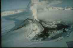
fileDescription: Veniaminof is a large stratovolcano with a summit caldera 180 km northeast of Pavlof on the Alaska peninsula. Its first historic eruption, in 1830, lasted for eight years; seven events have since been reported. Shown here is an oblique aerial view taken on January 23, 1984. An active lava flow has split. The recent November lava flow is snow-covered.
fileType: JPEG
descriptiveKeywords: (MD_Keywords)
keyword: EARTH SCIENCE > SOLID EARTH > Volcanoes > Eruption Dynamics
keyword: EARTH SCIENCE > SOLID EARTH > Volcanoes > Lava
keyword: EARTH SCIENCE > SOLID EARTH > Volcanoes > Magma
keyword: EARTH SCIENCE > SOLID EARTH > Volcanoes > Pyroclastics
keyword: EARTH SCIENCE > SOLID EARTH > Volcanoes > Volcanic Ash/Dust
type: (MD_KeywordTypeCode) theme
thesaurusName: (CI_Citation)
title: NASA/GCMD Earth Science Keywords
date: (unknown)
descriptiveKeywords: (MD_Keywords)
keyword: Lithosphere > Seismic activity > Seismic activity
keyword: Lithosphere > Volcanoes > Volcanoes
type: (MD_KeywordTypeCode) theme
thesaurusName: (CI_Citation)
title: INFOTERRA Keyword Thesaurus
date: (unknown)
descriptiveKeywords: (MD_Keywords)
keyword: ICSU-WDS > International Council for Science - World Data System
type: (MD_KeywordTypeCode) project
thesaurusName: (CI_Citation)
title: Global Change Master Directory (GCMD) Project Keywords
date: (CI_Date)
date: 2020-01-09
dateType: (CI_DateTypeCode) publication
edition: 9.1
citedResponsibleParty: (CI_ResponsibleParty)
organisationName: NASA Goddard Space Flight Center, Earth Science Data and Information System
contactInfo: (CI_Contact)
onlineResource: (CI_OnlineResource)
linkage: https://www.earthdata.nasa.gov/learn/find-data/idn/gcmd-keywords
name: Global Change Master Directory (GCMD) Keywords
description: The information provided on this page seeks to define how the GCMD Keywords are structured, used and accessed. It also provides information on how users can participate in the further development of the keywords.
function: (CI_OnLineFunctionCode) information
role: (CI_RoleCode) custodian
descriptiveKeywords: (MD_Keywords)
keyword: Global
type: (MD_KeywordTypeCode) place
thesaurusName: (CI_Citation)
title: NASA/GCMD Location Keywords
date: (unknown)
descriptiveKeywords: (MD_Keywords)
keyword: DOC/NOAA/NESDIS/NCEI > National Centers for Environmental Information, NESDIS, NOAA, U.S. Department of Commerce
keyword: DOC/NOAA/NESDIS/NGDC > National Geophysical Data Center, NESDIS, NOAA, U.S. Department of Commerce
type: (MD_KeywordTypeCode) dataCentre
thesaurusName: (CI_Citation)
title: Global Change Master Directory (GCMD) Data Center Keywords
date: (CI_Date)
date: 2020-01-09
dateType: (CI_DateTypeCode) publication
edition: 9.1
citedResponsibleParty: (CI_ResponsibleParty)
organisationName: NASA Goddard Space Flight Center, Earth Science Data and Information System
contactInfo: (CI_Contact)
onlineResource: (CI_OnlineResource)
linkage: https://www.earthdata.nasa.gov/learn/find-data/idn/gcmd-keywords
name: Global Change Master Directory (GCMD) Keywords
description: The information provided on this page seeks to define how the GCMD Keywords are structured, used and accessed. It also provides information on how users can participate in the further development of the keywords.
function: (CI_OnLineFunctionCode) information
role: (CI_RoleCode) custodian
resourceConstraints: (MD_LegalConstraints)
accessConstraints: (MD_RestrictionCode) otherRestrictions
useConstraints: (MD_RestrictionCode) otherRestrictions
otherConstraints: Access Constraints: None Use Constraints: None Distribution Liability: While every effort has been made to ensure that these data are accurate and reliable within the limits of the current state of the art, NOAA cannot assume liability for any damages caused by any errors or omissions in the data, nor as a result of the failure of the data to function on a particular system. NOAA makes no warranty, expressed or implied, nor does the fact of distribution constitute such a warranty.
aggregationInfo: (MD_AggregateInformation)
aggregateDataSetIdentifier: (MD_Identifier)
authority: (CI_Citation)
title: Container Packet ID
date: (unknown)
code: G01143
associationType: (DS_AssociationTypeCode)
language: eng; USA
topicCategory: (MD_TopicCategoryCode) geoscientificInformation
extent: (EX_Extent)
geographicElement: (EX_GeographicBoundingBox)
westBoundLongitude: -159.38
eastBoundLongitude: 175.63
southBoundLatitude: -39.16
northBoundLatitude: 63.3
temporalElement: (EX_TemporalExtent)
extent:
TimePeriod:
description: Publication Date
beginPosition: 1866-01-00
endPosition: 1986-03-00
return to top
contentInfo:
return to top
distributionInfo: (MD_Distribution)
distributionFormat: (MD_Format)
name: TIFF
version: (unknown)
distributor: (MD_Distributor)
distributorContact: (CI_ResponsibleParty)
organisationName: DOC/NOAA/NESDIS/NCEI > National Centers for Environmental Information, NESDIS, NOAA, U.S. Department of Commerce
positionName: User Services
contactInfo: (CI_Contact)
phone: (CI_Telephone)
voice: 303-497-6826
facsimile: 303-497-6513
address: (CI_Address)
deliveryPoint: 325 Broadway
city: Boulder
administrativeArea: CO
postalCode: 80305-3328
country: USA
electronicMailAddress: ngdc.info@noaa.gov
hoursOfService: 8am-5pm, Monday through Friday
role: (CI_RoleCode) distributor
transferOptions: (MD_DigitalTransferOptions)
transferSize:
Real: 20412
onLine: (CI_OnlineResource)
linkage: https://www.ngdc.noaa.gov/hazardimages/
onLine: (CI_OnlineResource)
linkage: https://www.ngdc.noaa.gov/hazard/
transferOptions: (MD_DigitalTransferOptions)
offLine: (MD_Medium)
name: (MD_MediumNameCode) cdRom
mediumFormat: (MD_MediumFormatCode) iso9660
return to top
dataQualityInfo: (DQ_DataQuality)
scope: (DQ_Scope)
level: (MD_ScopeCode) repository
levelDescription: (MD_ScopeDescription)
other: NOAA National Centers for Environmental Information
lineage: (LI_Lineage)
processStep: (LE_ProcessStep)
description: NOAA created the National Centers for Environmental Information (NCEI) by merging NOAA's National Climatic Data Center (NCDC), National Geophysical Data Center (NGDC), and National Oceanographic Data Center (NODC), including the National Coastal Data Development Center (NCDDC), per the Consolidated and Further Continuing Appropriations Act, 2015, Public Law 113-235. NCEI launched publicly on April 22, 2015.
dateTime:
DateTime: 2015-04-22T00:00:00
return to top
metadataMaintenance: (MD_MaintenanceInformation)
maintenanceAndUpdateFrequency: (unknown)
maintenanceNote: This metadata was automatically generated from the Content Standard for Digital Geospatial Metadata: Extensions for Remote Sensing Metadata standard version FGDC-STD-012-2002 using the June 2011 version of the FGDC RSE to ISO 19115-2 transform. The Spatial Reference Information is not currently mapped over to ISO but will be mapped in future versions.
maintenanceNote: This record was automatically modified on 2015-10-14 to include references to NCEI where applicable.
contact: (CI_ResponsibleParty)
organisationName: NOAA National Centers for Environmental Information
positionName: Metadata Specialist
role: (CI_RoleCode) editor
contact: (CI_ResponsibleParty)
organisationName: NOAA National Centers for Environmental Information
positionName: Hazards Data Manager
contactInfo: (CI_Contact)
address: (CI_Address)
electronicMailAddress: haz.info@noaa.gov
role: (CI_RoleCode) pointOfContact