Full Sun Drawings Composites Observed from IGY-D1
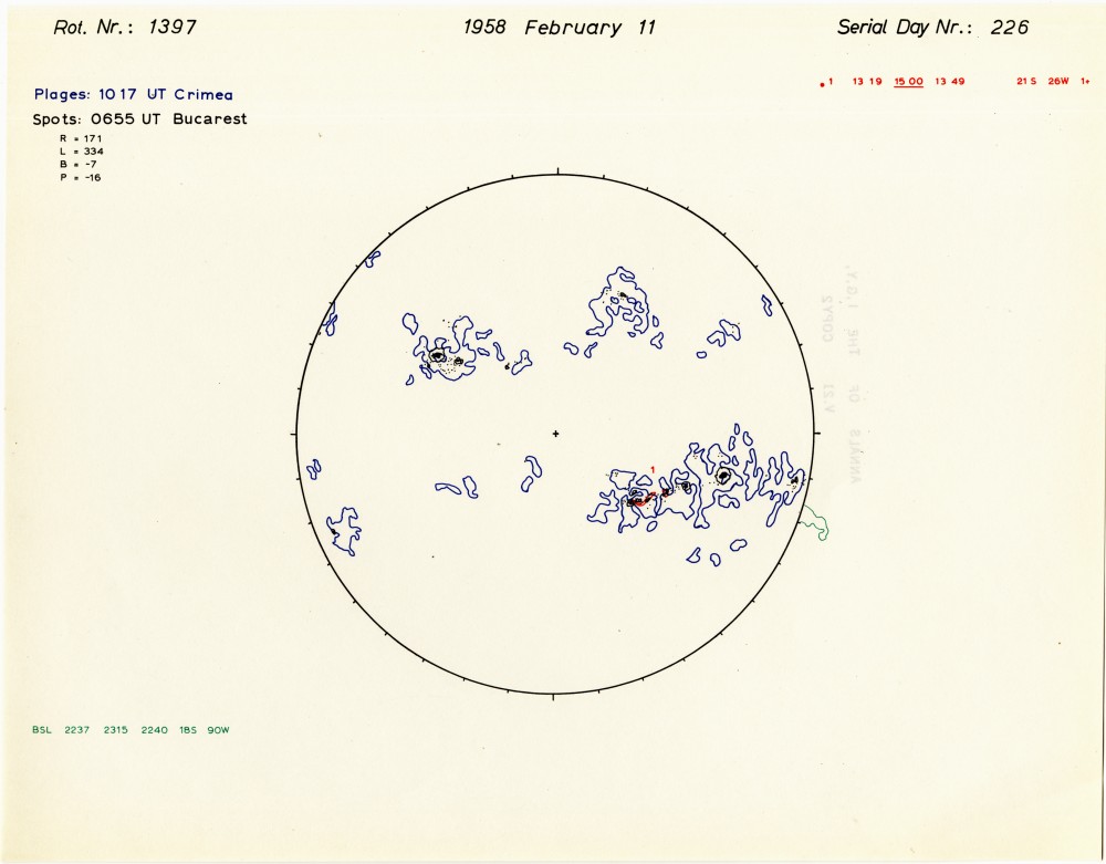 Example Image from Composites_Full Sun Drawings_igy1 series.
The decision to publish this volume of Solar Activity Maps (d2) in the Annuals of the International Geophyical Year was taken during the Fifth Meeting of the Special Commitee of Annual Geophysical International (CSAGI) held in Moscow, 30 July - 9 August 1958. The D-I series of I.G.Y. solar maps is a set of sketches, one for each day, of the following solar phnomena: sunspots, Bares, calcium plages, surges, and active prominences. Tracings are also given of the sequence of the development of some well-observed flares and prominence events.This documentation of the history of 1 1/2 years of solar activity during the I.G.Y. was made possible by the splendid cooperation of sixty observing stations throughout the world. Sunspots were traced from white-light drawings. The outlines of calcium plages were traced principally from spectroheliograms made in the calcium K line. A list of flare events was made with the importance I+ and greater, on the basis of all available observations. The I.G.Y. marked the first time that an attempt was made to assemble, systematically, reports of surges and active prominences from a number of world-wide observatories.
Dataset Citation
Cite this dataset when used as a source.
Dataset Identifiers
- Composites_Full Sun Drawings_igy1
ISO 19115-2 Metadata
gov.noaa.ngdc.stp.solar_imagery:Composites_Full_Sun_Drawings_igy1
| Download Data |
|
| Distribution Formats | Format not available |
| Distributor | William Denig DOC/NOAA/NESDIS/NCEI > National Centers for Environmental Information, NESDIS, NOAA, U.S. Department of Commerce (303) 497-6323 solar.ngdc@noaa.gov |
| Dataset Point of Contact | William Denig DOC/NOAA/NESDIS/NCEI > National Centers for Environmental Information, NESDIS, NOAA, U.S. Department of Commerce (303) 497-6323 solar.ngdc@noaa.gov |
| Coverage Description | Non-geographic |
| Time Period | 1957-07-01 to 1958-12-31 |
| Spatial Bounding Box Coordinates | Non-geographic |
| Documentation links not available. |
| Publication Dates |
|
| Data Presentation Form | Digital document - digital representation of a primarily textual item (can contain illustrations also) |
| Dataset Progress Status | Complete |
| Data Update Frequency | |
| Supplemental Information | The NOAA National Centers for Environmental Information (formally NGDC) provides scientific data stewardship of solar-terrestrial datasets in compliance with NOAA Administrative Order (NAO 212-15), "Management of Environmental Data and Information", published 04 Nov 10. Scientific Data Stewardship includes the Archive, Access, and Assessment (AAA) of operational and related solar and space environmental datasets. |
| Purpose | Scientific data stewardship of solar-terrestrial datasets in compliance with NOAA Administrative Order (NAO) 212-12, "Management of Environmental and Geospatial Data and Information", dated 04 Nov 10. Scientific Data Stewardship includes the Archive, Access, and Assessment (AAA) of operational and related solar and space environmental datasets. |
| Publishers |
|
| Theme keywords |
Global Change Master Directory (GCMD) Science Keywords
|
| Data Center keywords |
Global Change Master Directory (GCMD) Data Center Keywords
|
| Platform keywords |
Global Change Master Directory (GCMD) Platform Keywords
|
| Instrument keywords |
Global Change Master Directory (GCMD) Instrument Keywords
|
| Place keywords |
Global Change Master Directory (GCMD) Location Keywords
|
| Project keywords |
Global Change Master Directory (GCMD) Project Keywords
|
| Use Constraints | No constraint information available |
| Access Constraints |
|
| Fees | Fee information not available. |
| Acquisition Information (collection) | |
|---|---|
| Instrument | |
| Platform |
|
Last Modified: 2016-12-27
For questions about the information on this page, please email: Karen.E.Horan@noaa.gov
For questions about the information on this page, please email: Karen.E.Horan@noaa.gov