Full Sun Drawings Composites Observed from IGY-D1
(MI_Metadata)
fileIdentifier: gov.noaa.ngdc.stp.solar_imagery:Composites_Full_Sun_Drawings_igy1
language: eng; U.S.A.
characterSet: (MD_CharacterSetCode) utf8
hierarchyLevel: (MD_ScopeCode) nonGeographicDataset
hierarchyLevel: (MD_ScopeCode) series
contact: (CI_ResponsibleParty)
individualName: Karen E. Horan
organisationName: DOC/NOAA/NESDIS/NGDC > National Geophysical Data Center, NESDIS, NOAA, U.S. Department of Commerce
positionName:
contactInfo: (CI_Contact)
phone: (CI_Telephone)
voice: 303.497.6277
facsimile: 303.497.6513
address: (CI_Address)
deliveryPoint: NOAA/NESDIS/NGDC E/GC1 325 Broadway
city: Boulder
administrativeArea: CO
postalCode: 80305-3328
country: USA
electronicMailAddress: Karen.E.Horan@noaa.gov
hoursOfService: 7:30 - 5:00 Mountain
contactInstructions: Contact Data Center
role: (CI_RoleCode) custodian
dateStamp: 2016-12-27
metadataStandardName: ISO 19115-2 Geographic Information - Metadata - Part 2: Extensions for Imagery and Gridded Data
metadataStandardVersion: ISO 19115-2:2009(E)
return to top
identificationInfo: (MD_DataIdentification)
citation: (CI_Citation)
title: Full Sun Drawings Composites Observed from IGY-D1
date: (CI_Date)
date: 1957-07-01
dateType: (CI_DateTypeCode) creation
identifier: (MD_Identifier)
code: Composites_Full Sun Drawings_igy1
citedResponsibleParty: NCEI (custodian)
presentationForm: (CI_PresentationFormCode) documentDigital
abstract: The decision to publish this volume of Solar Activity Maps (d2) in the Annuals of the International Geophyical Year was taken during the Fifth Meeting of the Special Commitee of Annual Geophysical International (CSAGI) held in Moscow, 30 July - 9 August 1958. The D-I series of I.G.Y. solar maps is a set of sketches, one for each day, of the following solar phnomena: sunspots, Bares, calcium plages, surges, and active prominences. Tracings are also given of the sequence of the development of some well-observed flares and prominence events.This documentation of the history of 1 1/2 years of solar activity during the I.G.Y. was made possible by the splendid cooperation of sixty observing stations throughout the world. Sunspots were traced from white-light drawings. The outlines of calcium plages were traced principally from spectroheliograms made in the calcium K line. A list of flare events was made with the importance I+ and greater, on the basis of all available observations. The I.G.Y. marked the first time that an attempt was made to assemble, systematically, reports of surges and active prominences from a number of world-wide observatories.
purpose: Scientific data stewardship of solar-terrestrial datasets in compliance with NOAA Administrative Order (NAO) 212-12, "Management of Environmental and Geospatial Data and Information", dated 04 Nov 10. Scientific Data Stewardship includes the Archive, Access, and Assessment (AAA) of operational and related solar and space environmental datasets.
status: (MD_ProgressCode) Complete
pointOfContact: (CI_ResponsibleParty)
individualName: William Denig
organisationName: DOC/NOAA/NESDIS/NCEI > National Centers for Environmental Information, NESDIS, NOAA, U.S. Department of Commerce
contactInfo: (CI_Contact)
phone: (CI_Telephone)
voice: (303) 497-6323
facsimile: (303) 497-6513
address: (CI_Address)
deliveryPoint: 325 Broadway E/GC2
city: Boulder
administrativeArea: CO
postalCode: 80305
country: USA
electronicMailAddress: solar.ngdc@noaa.gov
hoursOfService: 7:30 - 4:30 Mountain
role: (CI_RoleCode) pointOfContact
resourceMaintenance: (MD_MaintenanceInformation)
maintenanceAndUpdateFrequency: (MD_MaintenanceFrequencyCode) nonePlanned
graphicOverview: (MD_BrowseGraphic)
fileName: https://www.ngdc.noaa.gov/stp/space-weather/solar-data/solar-imagery/composites/full-sun-drawings/igy1/documentation/browse_19580211_fd_igy.jpg
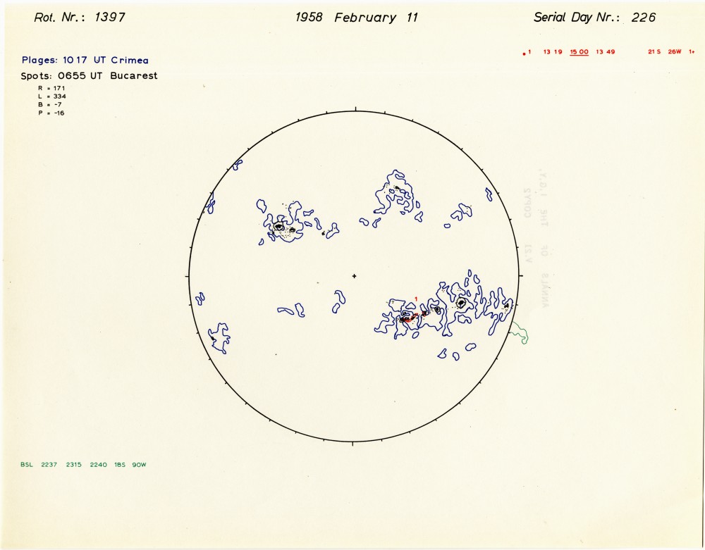
fileDescription: Example Image from Composites_Full Sun Drawings_igy1 series.
fileType: jpg
descriptiveKeywords: (MD_Keywords)
keyword: Sun-Earth Interactions > Solar Activity > Solar Active Regions
keyword: Sun-Earth Interactions > Solar Activity > Solar Imagery
keyword: Sun-Earth Interactions > Solar Activity > Sunspots
keyword: Sun-Earth Interactions > Solar Activity > Corona
keyword: Sun-Earth Interactions > Solar Activity > Solar Synoptic Maps
type: (MD_KeywordTypeCode) theme
thesaurusName: (CI_Citation)
title: Global Change Master Directory (GCMD) Science Keywords
date: (CI_Date)
date: 2020-01-09
dateType: (CI_DateTypeCode) publication
edition: 9.1
citedResponsibleParty: (CI_ResponsibleParty)
organisationName: NASA Goddard Space Flight Center, Earth Science Data and Information System
contactInfo: (CI_Contact)
onlineResource: (CI_OnlineResource)
linkage: https://www.earthdata.nasa.gov/learn/find-data/idn/gcmd-keywords
name: Global Change Master Directory (GCMD) Keywords
description: The information provided on this page seeks to define how the GCMD Keywords are structured, used and accessed. It also provides information on how users can participate in the further development of the keywords.
function: (CI_OnLineFunctionCode) information
role: (CI_RoleCode) custodian
descriptiveKeywords: (MD_Keywords)
keyword: Space > Solar Region > Composites
type: (MD_KeywordTypeCode) place
thesaurusName: (CI_Citation)
title: Global Change Master Directory (GCMD) Location Keywords
date: (CI_Date)
date: 2020-01-09
dateType: (CI_DateTypeCode) publication
edition: 9.1
citedResponsibleParty: (CI_ResponsibleParty)
organisationName: NASA Goddard Space Flight Center, Earth Science Data and Information System
contactInfo: (CI_Contact)
onlineResource: (CI_OnlineResource)
linkage: https://www.earthdata.nasa.gov/learn/find-data/idn/gcmd-keywords
name: Global Change Master Directory (GCMD) Keywords
description: The information provided on this page seeks to define how the GCMD Keywords are structured, used and accessed. It also provides information on how users can participate in the further development of the keywords.
function: (CI_OnLineFunctionCode) information
role: (CI_RoleCode) custodian
descriptiveKeywords: (MD_Keywords)
keyword: Solar Telescopes
type: (MD_KeywordTypeCode) instrument
thesaurusName: (CI_Citation)
title: Global Change Master Directory (GCMD) Instrument Keywords
date: (CI_Date)
date: 2020-01-09
dateType: (CI_DateTypeCode) publication
edition: 9.1
citedResponsibleParty: (CI_ResponsibleParty)
organisationName: NASA Goddard Space Flight Center, Earth Science Data and Information System
contactInfo: (CI_Contact)
onlineResource: (CI_OnlineResource)
linkage: https://www.earthdata.nasa.gov/learn/find-data/idn/gcmd-keywords
name: Global Change Master Directory (GCMD) Keywords
description: The information provided on this page seeks to define how the GCMD Keywords are structured, used and accessed. It also provides information on how users can participate in the further development of the keywords.
function: (CI_OnLineFunctionCode) information
role: (CI_RoleCode) custodian
descriptiveKeywords: (MD_Keywords)
keyword: Solar Observatory Stations
type: (MD_KeywordTypeCode) platform
thesaurusName: (CI_Citation)
title: Global Change Master Directory (GCMD) Platform Keywords
date: (CI_Date)
date: 2020-01-09
dateType: (CI_DateTypeCode) publication
edition: 9.1
citedResponsibleParty: (CI_ResponsibleParty)
organisationName: NASA Goddard Space Flight Center, Earth Science Data and Information System
contactInfo: (CI_Contact)
onlineResource: (CI_OnlineResource)
linkage: https://www.earthdata.nasa.gov/learn/find-data/idn/gcmd-keywords
name: Global Change Master Directory (GCMD) Keywords
description: The information provided on this page seeks to define how the GCMD Keywords are structured, used and accessed. It also provides information on how users can participate in the further development of the keywords.
function: (CI_OnLineFunctionCode) information
role: (CI_RoleCode) custodian
descriptiveKeywords: (MD_Keywords)
keyword: DOC/NOAA/NESDIS/NCEI > National Centers for Environmental Information, NESDIS, NOAA, U.S. Department of Commerce
keyword: DOC/NOAA/NESDIS/NGDC > National Geophysical Data Center, NESDIS, NOAA, U.S. Department of Commerce
type: (MD_KeywordTypeCode) dataCentre
thesaurusName: (CI_Citation)
title: Global Change Master Directory (GCMD) Data Center Keywords
date: (CI_Date)
date: 2020-01-09
dateType: (CI_DateTypeCode) publication
edition: 9.1
citedResponsibleParty: (CI_ResponsibleParty)
organisationName: NASA Goddard Space Flight Center, Earth Science Data and Information System
contactInfo: (CI_Contact)
onlineResource: (CI_OnlineResource)
linkage: https://www.earthdata.nasa.gov/learn/find-data/idn/gcmd-keywords
name: Global Change Master Directory (GCMD) Keywords
description: The information provided on this page seeks to define how the GCMD Keywords are structured, used and accessed. It also provides information on how users can participate in the further development of the keywords.
function: (CI_OnLineFunctionCode) information
role: (CI_RoleCode) custodian
descriptiveKeywords: (MD_Keywords)
keyword: NOAA > Space Weather Program
keyword: WDS > World Data Service for Geophysics, Boulder
type: (MD_KeywordTypeCode) project
thesaurusName: (CI_Citation)
title: Global Change Master Directory (GCMD) Project Keywords
date: (CI_Date)
date: 2020-01-09
dateType: (CI_DateTypeCode) publication
edition: 9.1
citedResponsibleParty: (CI_ResponsibleParty)
organisationName: NASA Goddard Space Flight Center, Earth Science Data and Information System
contactInfo: (CI_Contact)
onlineResource: (CI_OnlineResource)
linkage: https://www.earthdata.nasa.gov/learn/find-data/idn/gcmd-keywords
name: Global Change Master Directory (GCMD) Keywords
description: The information provided on this page seeks to define how the GCMD Keywords are structured, used and accessed. It also provides information on how users can participate in the further development of the keywords.
function: (CI_OnLineFunctionCode) information
role: (CI_RoleCode) custodian
resourceConstraints: (MD_LegalConstraints)
accessConstraints: (MD_RestrictionCode) otherRestrictions
otherConstraints: Distribution liability: NOAA and NCEI make no warranty, expressed or implied, regarding these data, nor does the fact of distribution constitute such a warranty. NOAA and NCEI cannot assume liability for any damages caused by any errors or omissions in these data. If appropriate, NCEI can only certify that the data it distributes are an authentic copy of the records that were accepted for inclusion in the NCEI archives.
spatialResolution: (MD_Resolution)
levelOfDetail:
language: eng; U.S.A.
topicCategory: (MD_TopicCategoryCode) climatologyMeteorologyAtmosphere
extent: (EX_Extent)
description: Non-geographic
temporalElement: (EX_TemporalExtent)
extent:
TimePeriod:
beginPosition: 1957-07-01
endPosition: 1958-12-31
supplementalInformation: The NOAA National Centers for Environmental Information (formally NGDC) provides scientific data stewardship of solar-terrestrial datasets in compliance with NOAA Administrative Order (NAO 212-15), "Management of Environmental Data and Information", published 04 Nov 10. Scientific Data Stewardship includes the Archive, Access, and Assessment (AAA) of operational and related solar and space environmental datasets.
return to top
distributionInfo: (MD_Distribution)
distributionFormat: (missing)
distributor: (MD_Distributor)
distributorContact: (CI_ResponsibleParty)
individualName: William Denig
organisationName: DOC/NOAA/NESDIS/NCEI > National Centers for Environmental Information, NESDIS, NOAA, U.S. Department of Commerce
contactInfo: (CI_Contact)
phone: (CI_Telephone)
voice: (303) 497-6323
facsimile: (303) 497-6513
address: (CI_Address)
deliveryPoint: 325 Broadway E/GC2
city: Boulder
administrativeArea: CO
postalCode: 80305
country: USA
electronicMailAddress: solar.ngdc@noaa.gov
hoursOfService: 7:30 - 4:30 Mountain
role: (CI_RoleCode) pointOfContact
transferOptions: (MD_DigitalTransferOptions)
unitsOfDistribution:
transferSize: (unknown)
onLine: (CI_OnlineResource)
linkage:
name: Composites_Full Sun Drawings_igy1 Directory
description: All images and related documentation.
function: (CI_OnLineFunctionCode) download
return to top
dataQualityInfo: (DQ_DataQuality)
scope: (DQ_Scope)
level: (MD_ScopeCode) series
report: (DQ_CompletenessCommission)
evaluationMethodDescription: Collection consists of daily solar images (photographs) and drawings provided by various solar observatories. The collection is as complete as possible with all available data online.
result: (unknown)
report: (DQ_ConceptualConsistency)
measureDescription: Observatory staff acquire data from one or more telescopes viewing the sun at various wavelengths to identify solar features of interest including the solar corona, plage regions, filaments and prominances.
result: (unknown)
report: (DQ_FormatConsistency)
evaluationMethodDescription: Consistent data presentation formats are used for each separate dataset.
result: (unknown)
report: (DQ_AbsoluteExternalPositionalAccuracy)
evaluationMethodDescription: Drawings are properly rotated into a heliocentric coordination orientation. Top is north. Right is east.
result: (unknown)
report: (DQ_ThematicClassificationCorrectness)
evaluationMethodDescription: Solar images and drawings were obtained and/or prepared by trained staff at the various institutions.
result: (unknown)
report: (DQ_AccuracyOfATimeMeasurement)
evaluationMethodDescription: Daily solar images and drawings are annotated with the observation time and other relevant metadata.
result: (unknown)
return to top
metadataMaintenance: (MD_MaintenanceInformation)
maintenanceAndUpdateFrequency: (MD_MaintenanceFrequencyCode) annually
maintenanceNote: This metadata was automatically generated from a form in in the Chameleon Editor (https://www.ngdc.noaa.gov/cedit) with solarimagery2iso.xsl on 2016-12-27.
return to top
acquisitionInformation: (MI_AcquisitionInformation)
instrument: (MI_Instrument)
identifier: (inapplicable)
type: Solar Telescopes
platform: (MI_Platform)
identifier: (MD_Identifier)
code: IGY-D1
description: TBD
instrument: (inapplicable)