Marine Trackline Geophysical Database
- referenceSystemInfo
- identificationInfo
- identificationInfo
- distributionInfo
- dataQualityInfo
- dataQualityInfo
- metadataMaintenance
- acquisitionInformation
(MI_Metadata)
fileIdentifier: gov.noaa.ngdc:G00129
hierarchyLevel: (MD_ScopeCode) dataset
contact: (CI_ResponsibleParty)
organisationName: NOAA National Centers for Environmental Information
contactInfo: (CI_Contact)
address: (CI_Address)
electronicMailAddress: ncei.info@noaa.gov
onlineResource: (CI_OnlineResource)
linkage: https://www.ncei.noaa.gov/contact
name: NCEI Contact Information
description: Information for contacts at NCEI.
function: (CI_OnLineFunctionCode) information
role: (CI_RoleCode) pointOfContact
dateStamp: 2023-09-15
metadataStandardName: ISO 19115-2 Geographic Information - Metadata - Part 2: Extensions for Imagery and Gridded Data
metadataStandardVersion: ISO 19115-2:2009(E)
return to top
referenceSystemInfo: (MD_ReferenceSystem)
referenceSystemIdentifier: (RS_Identifier)
authority: (inapplicable)
code: Through the collection reference systems have vaired with time and location. Please see survey level metadata for detailed information.
return to top
identificationInfo: (MD_DataIdentification)
citation: (CI_Citation)
title: Marine Trackline Geophysical Database
date: (CI_Date)
date: 1939
dateType: (CI_DateTypeCode) creation
date: (CI_Date)
date: 2023
dateType: (CI_DateTypeCode) revision
date: (CI_Date)
date: 2023-09-15
dateType: (CI_DateTypeCode) publication
identifier: (MD_Identifier)
authority: (CI_Citation)
title: International DOI Foundation (IDF)
date: (inapplicable)
code:
Anchor: DOI doi:10.7289/V5CZ35DR
identifier: (MD_Identifier)
authority: (CI_Citation)
title: NOAA National Centers for Environmental Information
date: (inapplicable)
code: NCEI Metadata ID: gov.noaa.ngdc:G00129
citedResponsibleParty: (CI_ResponsibleParty)
organisationName: NOAA National Centers for Environmental Information
role: (CI_RoleCode) publisher
citedResponsibleParty: (CI_ResponsibleParty)
organisationName: NOAA National Geophysical Data Center
role: (CI_RoleCode) author
citedResponsibleParty: (CI_ResponsibleParty)
organisationName: U.S. and Foreign Academic Institutions
role: (CI_RoleCode) originator
citedResponsibleParty: (CI_ResponsibleParty)
organisationName: U.S. and Foreign Government Agencies
role: (CI_RoleCode) originator
citedResponsibleParty: (CI_ResponsibleParty)
organisationName: Private Companies
role: (CI_RoleCode) originator
citedResponsibleParty: (CI_ResponsibleParty)
organisationName: (withheld)
contactInfo: (CI_Contact)
onlineResource: (CI_OnlineResource)
linkage: https://www.ngdc.noaa.gov/mgg/geodas/trackline.html
name: Marine Geophysical Trackline Data
description: Home page of Trackline Data
function: (CI_OnLineFunctionCode) information
role: (CI_RoleCode) custodian
abstract: This data set contains bathymetry, magnetic, gravity and seismic shot point navigation data collected during marine cruises from 1939 to the present. Coverage is worldwide. These data are stored in the MGD77 exchange format and are available for download in a variety of user selectable formats. One Header record and multiple Data records are available for a particular cruise/leg (port to port operation). The Header record documents both the content and the structure of the subsequent Data records, containing that part of the data that remains invariant throughout the cruise. The Data records present geophysical data (bathymetry, magnetics and gravity) and seismic information (shot-point identification) with a corresponding time and position. Documentation that varies within the cruise is also included with the data records. Data are fully searchable on-line by geographic area, year of cruise, institution, platform, cruise, date or data type.
purpose: Marine Research and Commercial Exploration
status: (MD_ProgressCode) completed
status: (MD_ProgressCode) historicalArchive
pointOfContact: (CI_ResponsibleParty)
organisationName: NOAA National Centers for Environmental Information
contactInfo: (CI_Contact)
address: (CI_Address)
electronicMailAddress: ncei.info@noaa.gov
onlineResource: (CI_OnlineResource)
linkage: https://www.ncei.noaa.gov/contact
name: NCEI Contact Information
description: Information for contacts at NCEI.
function: (CI_OnLineFunctionCode) information
role: (CI_RoleCode) pointOfContact
pointOfContact: (CI_ResponsibleParty)
organisationName: NOAA National Centers for Environmental Information
positionName: Trackline Team
contactInfo: (CI_Contact)
address: (CI_Address)
electronicMailAddress: trackline.info@noaa.gov
hoursOfService: 8:00 - 5:00 Mountain
role: (CI_RoleCode) pointOfContact
resourceMaintenance: (MD_MaintenanceInformation)
maintenanceAndUpdateFrequency: (MD_MaintenanceFrequencyCode) irregular
graphicOverview: (MD_BrowseGraphic)
fileName: https://ngdc.noaa.gov/mgg/image/trkmap256x235.gif
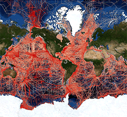
fileDescription: Map showing a web mercator projection of the trackline web map data discovery portal.
fileType: gif
descriptiveKeywords: (MD_Keywords)
keyword: Earth Science > Oceans > Bathymetry/Seafloor Topography > Water Depth
keyword: Earth Science > Oceans > Marine Geophysics > Magnetic Anomalies
keyword: Earth Science > Oceans > Marine Geophysics > Marine Gravity Field
keyword: Earth Science > Oceans > Marine Geophysics > Marine Magnetics
keyword: Earth Science > Solid Earth > Geodetics/Gravity > Gravity
keyword: Earth Science > Solid Earth > Geomagnetism > Magnetic Anomalies
keyword: Earth Science > Solid Earth > Geomagnetism > Magnetic Field
keyword: Earth Science > Solid Earth > Seismology > Seismic Profile
keyword: Earth Science > Oceans > Bathymetry/Seafloor Topography > Bathymetry
keyword: Earth Science > Oceans > Bathymetry/Seafloor Topography > Seafloor Topography
type: (MD_KeywordTypeCode) theme
thesaurusName: (CI_Citation)
title: Global Change Master Directory (GCMD) Science Keywords
date: (CI_Date)
date: 2020-01-09
dateType: (CI_DateTypeCode) publication
edition: 9.1
citedResponsibleParty: (CI_ResponsibleParty)
organisationName: NASA Goddard Space Flight Center, Earth Science Data and Information System
contactInfo: (CI_Contact)
onlineResource: (CI_OnlineResource)
linkage: https://www.earthdata.nasa.gov/learn/find-data/idn/gcmd-keywords
name: Global Change Master Directory (GCMD) Keywords
description: The information provided on this page seeks to define how the GCMD Keywords are structured, used and accessed. It also provides information on how users can participate in the further development of the keywords.
function: (CI_OnLineFunctionCode) information
role: (CI_RoleCode) custodian
descriptiveKeywords: (MD_Keywords)
keyword: INFOTERRA > Energy > Energy processes > Natural gas exploration
keyword: INFOTERRA > Energy > Energy processes > Oil exploration
keyword: INFOTERRA > Subject disciplines > Geophysics > Geophysics
type: (MD_KeywordTypeCode) theme
thesaurusName: (CI_Citation)
title: INFOTERRA Keyword Thesaurus
date: (unknown)
descriptiveKeywords: (MD_Keywords)
keyword: NGDA
keyword: National Geospatial Data Asset
keyword: Elevation Theme
type: (MD_KeywordTypeCode) theme
thesaurusName: (CI_Citation)
title: NGDA Portfolio Themes
date: (unknown)
descriptiveKeywords: (MD_Keywords)
keyword: ICSU-WDS > International Council for Science - World Data System
type: (MD_KeywordTypeCode) project
thesaurusName: (CI_Citation)
title: Global Change Master Directory (GCMD) Project Keywords
date: (CI_Date)
date: 2020-01-09
dateType: (CI_DateTypeCode) publication
edition: 9.1
citedResponsibleParty: (CI_ResponsibleParty)
organisationName: NASA Goddard Space Flight Center, Earth Science Data and Information System
contactInfo: (CI_Contact)
onlineResource: (CI_OnlineResource)
linkage: https://www.earthdata.nasa.gov/learn/find-data/idn/gcmd-keywords
name: Global Change Master Directory (GCMD) Keywords
description: The information provided on this page seeks to define how the GCMD Keywords are structured, used and accessed. It also provides information on how users can participate in the further development of the keywords.
function: (CI_OnLineFunctionCode) information
role: (CI_RoleCode) custodian
descriptiveKeywords: (MD_Keywords)
keyword: Geographic Region > Global Ocean
keyword: Vertical Location > Sea Floor
keyword: Ocean > Arctic Ocean
keyword: Ocean > Atlantic Ocean
keyword: Ocean > Indian Ocean
keyword: Ocean > Pacific Ocean
keyword: Ocean > Southern Ocean
type: (MD_KeywordTypeCode) place
thesaurusName: (CI_Citation)
title: Global Change Master Directory (GCMD) Location Keywords
date: (CI_Date)
date: 2020-01-09
dateType: (CI_DateTypeCode) publication
edition: 9.1
citedResponsibleParty: (CI_ResponsibleParty)
organisationName: NASA Goddard Space Flight Center, Earth Science Data and Information System
contactInfo: (CI_Contact)
onlineResource: (CI_OnlineResource)
linkage: https://www.earthdata.nasa.gov/learn/find-data/idn/gcmd-keywords
name: Global Change Master Directory (GCMD) Keywords
description: The information provided on this page seeks to define how the GCMD Keywords are structured, used and accessed. It also provides information on how users can participate in the further development of the keywords.
function: (CI_OnLineFunctionCode) information
role: (CI_RoleCode) custodian
descriptiveKeywords: (MD_Keywords)
keyword: DOC/NOAA/NESDIS/NCEI > National Centers for Environmental Information, NESDIS, NOAA, U.S. Department of Commerce
keyword: DOC/NOAA/NESDIS/NGDC > National Geophysical Data Center, NESDIS, NOAA, U.S. Department of Commerce
type: (MD_KeywordTypeCode) dataCentre
thesaurusName: (CI_Citation)
title: Global Change Master Directory (GCMD) Data Center Keywords
date: (CI_Date)
date: 2020-01-09
dateType: (CI_DateTypeCode) publication
edition: 9.1
citedResponsibleParty: (CI_ResponsibleParty)
organisationName: NASA Goddard Space Flight Center, Earth Science Data and Information System
contactInfo: (CI_Contact)
onlineResource: (CI_OnlineResource)
linkage: https://www.earthdata.nasa.gov/learn/find-data/idn/gcmd-keywords
name: Global Change Master Directory (GCMD) Keywords
description: The information provided on this page seeks to define how the GCMD Keywords are structured, used and accessed. It also provides information on how users can participate in the further development of the keywords.
function: (CI_OnLineFunctionCode) information
role: (CI_RoleCode) custodian
resourceConstraints: (MD_LegalConstraints)
accessConstraints: (MD_RestrictionCode) otherRestrictions
otherConstraints: Distribution liability: NOAA and NCEI make no warranty, expressed or implied, regarding these data, nor does the fact of distribution constitute such a warranty. NOAA and NCEI cannot assume liability for any damages caused by any errors or omissions in these data. If appropriate, NCEI can only certify that the data it distributes are an authentic copy of the records that were accepted for inclusion in the NCEI archives.
resourceConstraints: (MD_LegalConstraints)
useConstraints: (MD_RestrictionCode) otherRestrictions
otherConstraints: Use liability: NOAA and NCEI cannot provide any warranty as to the accuracy, reliability, or completeness of furnished data. Users assume responsibility to determine the usability of these data. The user is responsible for the results of any application of this data for other than its intended purpose.
resourceConstraints: (MD_Constraints)
useLimitation: Not to be used for navigation. Although these data are of high quality and useful for planning and modeling purposes, they are not suitable for navigation. For navigation, please refer to the NOS nautical chart series.
resourceConstraints: (MD_LegalConstraints)
otherConstraints: Cite as: NOAA National Geophysical Data Center. 1977: Marine Trackline Geophysical Database. NOAA National Centers for Environmental Information. https://doi.org/doi:10.7289/V5CZ35DR. Accessed [date].
language: eng; USA
topicCategory: (MD_TopicCategoryCode) oceans
extent: (EX_Extent)
geographicElement: (EX_GeographicBoundingBox)
westBoundLongitude: -180.00
eastBoundLongitude: 180.00
southBoundLatitude: -90.00
northBoundLatitude: 90.00
temporalElement: (EX_TemporalExtent)
extent:
TimePeriod:
beginPosition: 1939-01-01
endPosition:
return to top
identificationInfo: (SV_ServiceIdentification)
citation: (CI_Citation)
title: Geophysical Trackline Data ArcGIS Map Service
date: (CI_Date)
date: 2012-12-12
dateType: (CI_DateTypeCode) creation
citedResponsibleParty: (CI_ResponsibleParty)
organisationName: NOAA National Centers for Environmental Information
contactInfo: (CI_Contact)
onlineResource: (CI_OnlineResource)
linkage: https://ngdc.noaa.gov/mgg/geodas/trackline.html
name: Marine Geophysical Trackline Data at NCEI
description: Please see website for more information about Marine Geophysical Trackline Data.
function: (CI_OnLineFunctionCode) information
role: (CI_RoleCode) publisher
citedResponsibleParty: (CI_ResponsibleParty)
organisationName: NOAA National Centers for Environmental Information
contactInfo: (CI_Contact)
onlineResource: (CI_OnlineResource)
linkage: https://ngdc.noaa.gov/geomag/aromag.shtml
name: Airborne Magnetic Data
description: Please see website for more information about airborne magnetic data.
function: (CI_OnLineFunctionCode) information
role: (CI_RoleCode) publisher
citedResponsibleParty: (CI_ResponsibleParty)
organisationName: NOAA National Centers for Environmental Information
contactInfo: (CI_Contact)
onlineResource: (CI_OnlineResource)
linkage: https://noaa.maps.arcgis.com/home/item.html?id=9548e62e560d4fcc8183337c54124747
name: NOAA GeoPlatform Entry for Trackline Geophysical Data
description: NOAA GeoPlatform listing for Trackline Geophysical Data
function: (CI_OnLineFunctionCode) information
role: (CI_RoleCode) publisher
abstract: The Marine Trackline Geophysics database contains bathymetry, magnetics, gravity and seismic navigation data collected during marine cruises from 1939 to the present. Coverage is worldwide. Data sources include both US and foreign oceanographic institutions and government agencies. This map service shows tracks (both ship and airborne) for all geophysical surveys in the database, split into sub-layers by data type. This dynamic map service allows these sub-layers to be toggled on/off: All Survey Types (0) - visible by default; Bathymetry (1); Gravity (2); Magnetics (3); Multi-Channel Seismics (4); Seismic Refraction (5); Shot-Point Navigation (6); Side Scan Sonar (7); Single-Channel Seismics (8); Subbottom Profile (9); Aeromagnetic Surveys (10). Separate cached (tiled) map services are also available for several of these layers: All Survey Types (https://noaa.maps.arcgis.com/home/item.html?id=589adaec19ba48a9942ca9b13000c46d), Bathymetry (https://noaa.maps.arcgis.com/home/item.html?id=09dba3b48e8b49f4bcbf21f6e51ef6ed), Gravity (https://noaa.maps.arcgis.com/home/item.html?id=00cb8aa7607b4f11b78ef5a0e77921f5), Magnetics (https://noaa.maps.arcgis.com/home/item.html?id=09d6cfa8909545ddbfe93657ad761222), and Single-Channel Seismics (https://noaa.maps.arcgis.com/home/item.html?id=ff835a5df139428f992a6066151ffdda).
pointOfContact: (CI_ResponsibleParty)
individualName: NCEI GIS Team
organisationName: NOAA National Centers for Environmental Information
contactInfo: (CI_Contact)
address: (CI_Address)
electronicMailAddress: ncei.gis@noaa.gov
role: (CI_RoleCode) pointOfContact
descriptiveKeywords: (MD_Keywords)
keyword: DATA ANALYSIS AND VISUALIZATION > GEOGRAPHIC INFORMATION SYSTEMS > WEB-BASED GEOGRAPHIC INFORMATION SYSTEMS
keyword: DATA MANAGEMENT/DATA HANDLING > DATA SEARCH AND RETRIEVAL
keyword: DATA ANALYSIS AND VISUALIZATION > VISUALIZATION/IMAGE PROCESSING
type: (MD_KeywordTypeCode) theme
thesaurusName: (CI_Citation)
title: Global Change Master Directory (GCMD) Service Keywords
date: (CI_Date)
date: 2020-01-09
dateType: (CI_DateTypeCode) publication
edition: 9.1
citedResponsibleParty: (CI_ResponsibleParty)
organisationName: NASA Goddard Space Flight Center, Earth Science Data and Information System
contactInfo: (CI_Contact)
onlineResource: (CI_OnlineResource)
linkage: https://www.earthdata.nasa.gov/learn/find-data/idn/gcmd-keywords
name: Global Change Master Directory (GCMD) Keywords
description: The information provided on this page seeks to define how the GCMD Keywords are structured, used and accessed. It also provides information on how users can participate in the further development of the keywords.
function: (CI_OnLineFunctionCode) information
role: (CI_RoleCode) custodian
resourceConstraints: (MD_Constraints)
useLimitation: These data not to be used for navigation. Although these data are of high quality and useful for planning and modeling purposes, they are not suitable for navigation. For official navigation products, please refer to the U.S. nautical charts available from the NOAA Office of Coast Survey: http://www.nauticalcharts.noaa.gov.
serviceType:
LocalName: ArcGIS Map Service
serviceTypeVersion: 10.7
extent: (EX_Extent)
geographicElement: (EX_GeographicBoundingBox)
extentTypeCode: 1
westBoundLongitude: -180
eastBoundLongitude: 180
southBoundLatitude: -90
northBoundLatitude: 90
couplingType: (SV_CouplingType) tight
containsOperations: (SV_OperationMetadata)
operationName: ArcGIS Server REST endpoint for dynamic map service
DCP: (unknown)
connectPoint: (CI_OnlineResource)
linkage: https://gis.ngdc.noaa.gov/arcgis/rest/services/web_mercator/trackline_combined_dynamic/MapServer
protocol: http
applicationProfile: http://www.geoplatform.gov/spec/esri-map-rest
name: Geophysical Trackline Data ArcGIS Dynamic Map Service
description: REST endpoint for Geophysical Trackline Data dynamic map service
function: (CI_OnLineFunctionCode) search
containsOperations: (SV_OperationMetadata)
operationName: WMS Get Capabilities
DCP:
connectPoint: (CI_OnlineResource)
linkage: https://gis.ngdc.noaa.gov/arcgis/services/web_mercator/trackline_combined_dynamic/MapServer/WMSServer?request=GetCapabilities&service=WMS
protocol: http
applicationProfile: http://opengis.net/spec/wms
name: Geophysical Trackline Data Web Map Service (WMS)
description: Capabilities document for Open Geospatial Consortium Web Map Service for Geophysical Trackline Data
function: (CI_OnLineFunctionCode) search
return to top
distributionInfo: (MD_Distribution)
distributor: (MD_Distributor)
distributorContact: (CI_ResponsibleParty)
organisationName: NOAA National Centers for Environmental Information
contactInfo: (CI_Contact)
address: (CI_Address)
electronicMailAddress: ncei.info@noaa.gov
onlineResource: (CI_OnlineResource)
linkage: https://www.ncei.noaa.gov/contact
name: NCEI Contact Information
description: Information for contacts at NCEI.
function: (CI_OnLineFunctionCode) information
role: (CI_RoleCode) distributor
distributionOrderProcess: (MD_StandardOrderProcess)
fees: In most cases, electronic downloads of the data are free. However, fees may apply for custom orders, data certifications, copies of analog materials, and data distribution on physical media.
orderingInstructions: Ordering Instructions: Trackline data can be obtained by visiting the Geophysical Survey Data Viewer. The user must then select the desired parameters (bathymetry, magnetics, gravity or seismic) and any other applicable filters. The user is then able to get all of the data that fit this criteria (within certain size limits) or may further refine their request by designating an area of interest. The user is then taken to a landing page where they can further refine the data that they would like to be delivered, format, and any other data that is available. The user then provides an email address where the user will be informed when their data package is available for download.
distributorFormat: (MD_Format)
name: MGD77T
version: (unknown)
distributorFormat: (MD_Format)
name: XYZ
version: (unknown)
distributorTransferOptions: (MD_DigitalTransferOptions)
onLine: (CI_OnlineResource)
linkage: http://maps.ngdc.noaa.gov/viewers/geophysics/
name: Geophysical Survey Data Viewer
description: Search for Marine Geophysical Trackline Data using our web based map viewer.
function: (CI_OnLineFunctionCode) search
distributorTransferOptions: (MD_DigitalTransferOptions)
onLine: (CI_OnlineResource)
linkage: https://www.ngdc.noaa.gov/mgg/geodas/trackline.html
name: Marine Geophysical Trackline Data Homepage
description: NCEI's Marine Trackline Geophysical database provides access to bathymetry, magnetics, gravity and seismic reflection data collected during marine cruises from 1939 to the present. Coverage is worldwide. Data sources include both US and non-US oceanographic institutions, universities, and government agencies.
function: (CI_OnLineFunctionCode) information
return to top
dataQualityInfo: (DQ_DataQuality)
scope: (DQ_Scope)
level: (MD_ScopeCode) repository
levelDescription: (MD_ScopeDescription)
other: NOAA National Centers for Environmental Information
lineage: (LI_Lineage)
processStep: (LE_ProcessStep)
description: NOAA created the National Centers for Environmental Information (NCEI) by merging NOAA's National Climatic Data Center (NCDC), National Geophysical Data Center (NGDC), and National Oceanographic Data Center (NODC), including the National Coastal Data Development Center (NCDDC), per the Consolidated and Further Continuing Appropriations Act, 2015, Public Law 113-235. NCEI launched publicly on April 22, 2015.
dateTime:
DateTime: 2015-04-22T00:00:00
return to top
dataQualityInfo: (DQ_DataQuality)
scope: (DQ_Scope)
level: (MD_ScopeCode) dataset
lineage: (LI_Lineage)
source: (LI_Source)
description: Data in this database is provided by the following institutions: Scripps Institution of Oceanography, Lamont-Doherty Geological Observatory, Geological Survey of Japan, Hydrographic Department of Japan, University of Hawaii, IFREMER, US National Oceanic and Atmospheric Administration, United States Geologic Survey, Woods Hole Oceanographic Institution, US Navy Naval Oceanographic Office, Ocean Drilling Program at Texas A and M, Bundesanstalt für Geowissenschaften und Rohstoffe, Bedford Institute of Oceanography, University of Texas Institute for Geophysics, Institute of Oceanographic Sciences UK, CNEXO, Oregon State University, Bureau of Mineral Resources Australia, Geophysics Division DSIR New Zealand, US Navy NORDA, Texas A and M University, Natural Environment Research Council UK, BNDO, GNS Science New Zealand, University of Tokyo, Geological Survey of Canada, Australian Geological Survey Organisation, GEOMER Data Bank ORSTOM Noumea, Kobe University, Canadian Hydrographic Service, Mobil, Hydrographic Department MSA, Institute of Marine Geology/Geophysics USSR, Oregon State University, United Kingdom Hydrographic Office, University of Rhode Island, Geological Survey of Ireland, GEOMAR Germany, NIWA New Zealand, Russian Academy of Science, South African Data Centre for Oceanography, University of Witwatersrand, Royal Netherlands Navy Hydrographic Service, Chiba University, Land Information New Zealand, Southampton Oceanography Centre, University of Cape Town, University of the Ryukyus, Bundesamt Seeschiffahrt Hydrographie, GuangZhou Marine Geological Survey MGMR, National Institute of Polar Research Japan, National Science Foundation, ORSTOM, Rice University, South African Geological Survey, University of Alabama, University of Cape Town, University of Texas at Austin, University of Rhode Island, BP Shell Todd, British Antarctic Survey, British Oceanographic Data Centre, Diamond Shamrock Petroleum, Far East Scientific Center, First Institute of Oceanography, SOA, Hamilton College, Institut de Physique du Globe de Paris, Jet Propulsion Laboratory, National Research Institute Oceanology South Africa, Petrocorp, Stewart Petroleum, Universite Francaise Pacifique Tahiti, University of California at San Diego
return to top
metadataMaintenance: (MD_MaintenanceInformation)
maintenanceAndUpdateFrequency: (MD_MaintenanceFrequencyCode) asNeeded
maintenanceNote: Modified for compliance to NCEI Template v1.2.
return to top
acquisitionInformation: (MI_AcquisitionInformation)
instrument: (MI_Instrument)
identifier: (MD_Identifier)
code: ECHO SOUNDERS
type: (missing)
instrument: (MI_Instrument)
identifier: (MD_Identifier)
code: GRAVIMETERS
type: (missing)
instrument: (MI_Instrument)
identifier: (MD_Identifier)
code: MAGNETOMETERS
type: (missing)
instrument: (MI_Instrument)
identifier: (MD_Identifier)
code: SEISMIC REFLECTION PROFILERS
type: (missing)