NOS Hydrographic Surveys Collection
National Geospatial Data Asset (NGDA) NOS Hydrographic Surveys
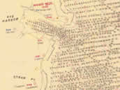 1950s smooth sheet
The National Oceanic and Atmospheric Administration (NOAA) has the statutory mandate to collect hydrographic data in support of nautical chart compilation for safe navigation and to provide background data for engineers, scientific, and other commercial and industrial activities. Hydrographic survey data primarily consist of water depths, but may also include features (e.g. rocks, wrecks), navigation aids, shoreline identification, and bottom type information. NOAA is responsible for archiving and distributing the source data as described in this metadata record. Survey types are B: Hydrographic EEZ Surveys; D: Discovery Surveys; H: Hydrographic Surveys; F: Field Edit Surveys; W: Non-NOS Hydrographic Surveys.
- Cite as: NOAA National Ocean Service. 2012: NOS Hydrographic Surveys Collection. [indicate subset used]. NOAA National Centers for Environmental Information. Accessed [date].
- NCEI Metadata ID: gov.noaa.ngdc:NOS_Hydrographic_Survey_Collection
gov.noaa.ngdc:NOS_Hydrographic_Survey_Collection
| Search Data |
|
| Distribution Formats |
- Bathymetry Attributed Grid (BAG)
- File Specification: Bathymetric Attributed Grid (BAG) is a non-proprietary file format for storing and exchanging bathymetric data developed by the Open Navigation Surface Working Group. BAG files are gridded, multi-dimensional bathymetric data files and is the standard NOS hydrographic data file for public release.
- Geospatial Portable Document Format (GeoImage)
- File Specification: Geospatial Portable Document Format (GeoImage) is a layered geospatial PDF. This image file contains several layers including: a combined bathymetric surface, a survey scale set of soundings, a large scale raster nautical chart, latitude/longitude graticule, title block, and an acoustic imagery mosaic (if available). The image is also geographically referenced, allowing users to locate features, measure distances and angles, and select specific layers of interest
- ASCII XYZ
- TIFF
- PDF
- Generic Sensor Format (GSF)
- Multi-resolution Seamless Image Database (MrSID)
|
| Ordering Instructions |
Contact NCEI for other distribution options and instructions. |
| Distributor |
NOAA National Centers for Environmental Information
ncei.info@noaa.gov
|
| Dataset Point of Contact |
NOAA National Centers for Environmental Information
ncei.info@noaa.gov
|
| Dataset Point of Contact |
Bathymetric Data Acquisition Program Manager
NOAA National Centers for Environmental Information
(303) 497-6429
hydro.Info@noaa.gov or
NGDC.Seafloor.data@noaa.gov
|
| Time Period |
1837-05-23 to Present |
| Spatial Reference System |
Through the collection reference systems have vaired with time and location. Please see survey level metadata for detailed information. |
| Spatial Bounding Box Coordinates |
West: -180
East: 180
South: -90
North: 90
|
| Spatial Coverage Map |
|
| General Documentation |
- Metadata Landing Page
-
NOS Hydrographic Survey Data Home Page
Home page for digitized data from smooth sheets of hydrographic surveys completed between 1837 and 1965, and from survey data acquired digitally on NOS survey vessels since 1965. Over 76 million soundings from over 6,600 surveys are included. NGDC has developed an interactive map and data discovery tool, the Bathymetry Map Service, and a text-based search engine, the Hydrographic Survey Text Search, which enable rapid data discovery and download.
|
| Associated Resources |
- Data Stewardship Maturity Report for Ocean Office of Coast Survey Hydrographic Data
|
| Publication Dates |
- creation: 2012-03-02
- revision: 2023-09-15
- publication: 2012-03-02
|
| Dataset Progress Status |
Ongoing - data is continually being updated
Historical archive - data has been stored in an offline storage facility |
| Data Update Frequency |
Data update frequency not available |
| Purpose |
These hydrographic data are made available to the public for a wide variety of uses, such as sea-bottom characterization, habitat classification, coastal studies, boundary issues, and tsunami forecasting. These data are not intended to be used for navigation. Nautical charts produced and certified by NOAA should be used for navigation purposes. |
| Dataset Citation |
- Cite as: NOAA National Ocean Service. 2012: NOS Hydrographic Surveys Collection. [indicate subset used]. NOAA National Centers for Environmental Information. Accessed [date].
|
| Cited Authors |
- NOAA National Ocean Service
|
| Publishers |
- NOAA National Centers for Environmental Information
|
| Theme keywords |
Global Change Master Directory (GCMD) Science Keywords
- EARTH SCIENCE > Oceans > Bathymetry/Seafloor Topography > Bathymetry
- EARTH SCIENCE > Oceans > Bathymetry/Seafloor Topography > Seafloor Topography
- EARTH SCIENCE > Oceans > Bathymetry/Seafloor Topography > Water Depth
- EARTH SCIENCE > Oceans > Marine Sediments > Sediment Composition
NGDA Portfolio Themes
- NGDA
- National Geospatial Data Asset
- Elevation Theme
Global Change Master Directory (GCMD) Service Keywords
- DATA ANALYSIS AND VISUALIZATION > GEOGRAPHIC INFORMATION SYSTEMS > WEB-BASED GEOGRAPHIC INFORMATION SYSTEMS
- DATA MANAGEMENT/DATA HANDLING > DATA SEARCH AND RETRIEVAL
- DATA ANALYSIS AND VISUALIZATION > VISUALIZATION/IMAGE PROCESSING
Global Change Master Directory (GCMD) Service Keywords
- DATA ANALYSIS AND VISUALIZATION > GEOGRAPHIC INFORMATION SYSTEMS > WEB-BASED GEOGRAPHIC INFORMATION SYSTEMS
- DATA MANAGEMENT/DATA HANDLING > DATA SEARCH AND RETRIEVAL
- DATA ANALYSIS AND VISUALIZATION > VISUALIZATION/IMAGE PROCESSING
|
| Data Center keywords |
Global Change Master Directory (GCMD) Data Center Keywords
- DOC/NOAA/NESDIS/NCEI > National Centers for Environmental Information, NESDIS, NOAA, U.S. Department of Commerce
- DOC/NOAA/NESDIS/NGDC > National Geophysical Data Center, NESDIS, NOAA, U.S. Department of Commerce
|
| Instrument keywords |
Global Change Master Directory (GCMD) Instrument Keywords
- In Situ/Laboratory Instruments > Profilers/Sounders > Acoustic Sounders > > MSBS > Multibeam Swath Bathymetry System
- In Situ/Laboratory Instruments > Profilers/Sounders > Acoustic Sounders > > MBES > Multibeam Mapping System
- In Situ/Laboratory Instruments > Profilers/Sounders > Acoustic Sounders > > SONAR > Sound Navigation and Ranging
- In Situ/Laboratory Instruments > Profilers/Sounders > Acoustic Sounders
- Earth Remote Sensing Instruments > Passive Remote Sensing > Positioning/Navigation > GPS > GPS RECEIVERS
- Earth Remote Sensing Instruments > Passive Remote Sensing > Positioning/Navigation > GPS > GPS/IMU > Global Positioning System/Inertial Measurement Unit
|
| Place keywords |
Getty Thesaurus of Geographic Names
- CONTINENT > NORTH AMERICA > UNITED STATES OF AMERICA
- OCEAN
|
| Project keywords |
- Hydrographic Surveys for Selected Locations Within the United States
Global Change Master Directory (GCMD) Project Keywords
|
| Use Constraints |
- Use liability: NOAA and NCEI cannot provide any warranty as to the accuracy, reliability, or completeness of furnished data. Users assume responsibility to determine the usability of these data. The user is responsible for the results of any application of this data for other than its intended purpose.
|
| Access Constraints |
- Distribution liability: NOAA and NCEI make no warranty, expressed or implied, regarding these data, nor does the fact of distribution constitute such a warranty. NOAA and NCEI cannot assume liability for any damages caused by any errors or omissions in these data. If appropriate, NCEI can only certify that the data it distributes are an authentic copy of the records that were accepted for inclusion in the NCEI archives.
|
| Other Constraints |
These data are NOT to be used for navigation. |
| Other Constraints |
Cite as: NOAA National Ocean Service. 2012: NOS Hydrographic Surveys Collection. [indicate subset used]. NOAA National Centers for Environmental Information. Accessed [date]. |
| Fees |
- In most cases, electronic downloads of the data are free. However, fees may apply for custom orders, data certifications, copies of analog materials, and data distribution on physical media.
|
| Lineage information for: repository |
|---|
| Processing Steps |
- 2015-04-22T00:00:00 - NOAA created the National Centers for Environmental Information (NCEI) by merging NOAA's National Climatic Data Center (NCDC), National Geophysical Data Center (NGDC), and National Oceanographic Data Center (NODC), including the National Coastal Data Development Center (NCDDC), per the Consolidated and Further Continuing Appropriations Act, 2015, Public Law 113-235. NCEI launched publicly on April 22, 2015.
|
Last Modified: 2023-09-15
For questions about the information on this page, please email:
ncei.info@noaa.gov