NOS Hydrographic Surveys Collection
- referenceSystemInfo
- metadataExtensionInfo
- identificationInfo
- identificationInfo
- identificationInfo
- contentInfo
- distributionInfo
- dataQualityInfo
- dataQualityInfo
- metadataMaintenance
(MI_Metadata)
fileIdentifier: gov.noaa.ngdc:NOS_Hydrographic_Survey_Collection
hierarchyLevel: (MD_ScopeCode) series
contact: (CI_ResponsibleParty)
organisationName: NOAA National Centers for Environmental Information
contactInfo: (CI_Contact)
address: (CI_Address)
electronicMailAddress: ncei.info@noaa.gov
onlineResource: (CI_OnlineResource)
linkage: https://www.ncei.noaa.gov/contact
name: NCEI Contact Information
description: Information for contacts at NCEI.
function: (CI_OnLineFunctionCode) information
role: (CI_RoleCode) pointOfContact
dateStamp: 2023-09-15
metadataStandardName: ISO 19115-2 Geographic Information - Metadata - Part 2: Extensions for Imagery and Gridded Data
metadataStandardVersion: ISO 19115-2:2009(E)
return to top
referenceSystemInfo: (MD_ReferenceSystem)
referenceSystemIdentifier: (RS_Identifier)
authority: (inapplicable)
code: Through the collection reference systems have vaired with time and location. Please see survey level metadata for detailed information.
return to top
metadataExtensionInfo: (MD_MetadataExtensionInformation)
extensionOnLineResource: (CI_OnlineResource)
linkage: http://www.ngdc.noaa.gov/metadata/published/xsd/schema/resources/extensions/MD_MetadataExtensionInformation.xml
applicationProfile: xml
name: MD_MetadataExtensionInformation.xml
description: Metadata Extension Information
function: (CI_OnLineFunctionCode) information
return to top
identificationInfo: (MD_DataIdentification)
citation: (CI_Citation)
title: NOS Hydrographic Surveys Collection
alternateTitle: National Geospatial Data Asset (NGDA) NOS Hydrographic Surveys
date: (CI_Date)
date: 2012-03-02
dateType: (CI_DateTypeCode) creation
date: (CI_Date)
date: 2023-09-15
dateType: (CI_DateTypeCode) revision
date: (CI_Date)
date: 2012-03-02
dateType: (CI_DateTypeCode) publication
identifier: (MD_Identifier)
authority: (CI_Citation)
title: NOAA National Centers for Environmental Information
date: (inapplicable)
code: NCEI Metadata ID: gov.noaa.ngdc:NOS_Hydrographic_Survey_Collection
citedResponsibleParty: (CI_ResponsibleParty)
organisationName: NOAA National Centers for Environmental Information
role: (CI_RoleCode) publisher
citedResponsibleParty: (CI_ResponsibleParty)
organisationName: NOAA National Ocean Service
role: (CI_RoleCode) author
abstract: The National Oceanic and Atmospheric Administration (NOAA) has the statutory mandate to collect hydrographic data in support of nautical chart compilation for safe navigation and to provide background data for engineers, scientific, and other commercial and industrial activities. Hydrographic survey data primarily consist of water depths, but may also include features (e.g. rocks, wrecks), navigation aids, shoreline identification, and bottom type information. NOAA is responsible for archiving and distributing the source data as described in this metadata record. Survey types are B: Hydrographic EEZ Surveys; D: Discovery Surveys; H: Hydrographic Surveys; F: Field Edit Surveys; W: Non-NOS Hydrographic Surveys.
purpose: These hydrographic data are made available to the public for a wide variety of uses, such as sea-bottom characterization, habitat classification, coastal studies, boundary issues, and tsunami forecasting. These data are not intended to be used for navigation. Nautical charts produced and certified by NOAA should be used for navigation purposes.
status: (MD_ProgressCode) onGoing
status: (MD_ProgressCode) historicalArchive
pointOfContact: (CI_ResponsibleParty)
organisationName: NOAA National Centers for Environmental Information
contactInfo: (CI_Contact)
address: (CI_Address)
electronicMailAddress: ncei.info@noaa.gov
onlineResource: (CI_OnlineResource)
linkage: https://www.ncei.noaa.gov/contact
name: NCEI Contact Information
description: Information for contacts at NCEI.
function: (CI_OnLineFunctionCode) information
role: (CI_RoleCode) pointOfContact
pointOfContact: (CI_ResponsibleParty)
organisationName: NOAA National Centers for Environmental Information
positionName: Bathymetric Data Acquisition Program Manager
contactInfo: (CI_Contact)
phone: (CI_Telephone)
voice: (303) 497-6429
address: (CI_Address)
electronicMailAddress: hydro.Info@noaa.gov
electronicMailAddress: NGDC.Seafloor.data@noaa.gov
role: (CI_RoleCode) pointOfContact
graphicOverview: (MD_BrowseGraphic)
fileName: https://www.ngdc.noaa.gov/mgg/image/nossmoothsheeticon.jpg
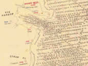
fileDescription: 1950s smooth sheet
fileType: JPG
descriptiveKeywords: (MD_Keywords)
keyword: EARTH SCIENCE > Oceans > Bathymetry/Seafloor Topography > Bathymetry
keyword: EARTH SCIENCE > Oceans > Bathymetry/Seafloor Topography > Seafloor Topography
keyword: EARTH SCIENCE > Oceans > Bathymetry/Seafloor Topography > Water Depth
keyword: EARTH SCIENCE > Oceans > Marine Sediments > Sediment Composition
type: (MD_KeywordTypeCode) theme
thesaurusName: (CI_Citation)
title: Global Change Master Directory (GCMD) Science Keywords
date: (CI_Date)
date: 2020-01-09
dateType: (CI_DateTypeCode) publication
edition: 9.1
citedResponsibleParty: (CI_ResponsibleParty)
organisationName: NASA Goddard Space Flight Center, Earth Science Data and Information System
contactInfo: (CI_Contact)
onlineResource: (CI_OnlineResource)
linkage: https://www.earthdata.nasa.gov/learn/find-data/idn/gcmd-keywords
name: Global Change Master Directory (GCMD) Keywords
description: The information provided on this page seeks to define how the GCMD Keywords are structured, used and accessed. It also provides information on how users can participate in the further development of the keywords.
function: (CI_OnLineFunctionCode) information
role: (CI_RoleCode) custodian
descriptiveKeywords: (MD_Keywords)
keyword: Hydrographic Surveys for Selected Locations Within the United States
type: (MD_KeywordTypeCode) project
thesaurusName: (inapplicable)
descriptiveKeywords: (MD_Keywords)
keyword: CONTINENT > NORTH AMERICA > UNITED STATES OF AMERICA
keyword: OCEAN
type: (MD_KeywordTypeCode) place
thesaurusName: (CI_Citation)
title: Getty Thesaurus of Geographic Names
date: (CI_Date)
date: 2011-04-11
dateType: (CI_DateTypeCode) revision
citedResponsibleParty: (CI_ResponsibleParty)
organisationName: Getty Research Institute
contactInfo: (CI_Contact)
address: (CI_Address)
deliveryPoint: 1200 Getty Center Drive, Suite 1100
city: Los Angeles
administrativeArea: California
postalCode: 90049-1688
country: United States
electronicMailAddress: TGN@getty.edu
onlineResource: (CI_OnlineResource)
linkage: http://www.getty.edu/research/tools/vocabularies/tgn/index.html
name: Getty Thesaurus of Geographic Names Online Page
description: This page provides an interface to search the Getty Thesaurus of Geographic Names.
function: (CI_OnLineFunctionCode) information
role: (CI_RoleCode) custodian
descriptiveKeywords: (MD_Keywords)
keyword: In Situ/Laboratory Instruments > Profilers/Sounders > Acoustic Sounders > > MSBS > Multibeam Swath Bathymetry System
keyword: In Situ/Laboratory Instruments > Profilers/Sounders > Acoustic Sounders > > MBES > Multibeam Mapping System
keyword: In Situ/Laboratory Instruments > Profilers/Sounders > Acoustic Sounders > > SONAR > Sound Navigation and Ranging
keyword: In Situ/Laboratory Instruments > Profilers/Sounders > Acoustic Sounders
keyword: Earth Remote Sensing Instruments > Passive Remote Sensing > Positioning/Navigation > GPS > GPS RECEIVERS
keyword: Earth Remote Sensing Instruments > Passive Remote Sensing > Positioning/Navigation > GPS > GPS/IMU > Global Positioning System/Inertial Measurement Unit
type: (MD_KeywordTypeCode) instrument
thesaurusName: (CI_Citation)
title: Global Change Master Directory (GCMD) Instrument Keywords
date: (CI_Date)
date: 2020-01-09
dateType: (CI_DateTypeCode) publication
edition: 9.1
citedResponsibleParty: (CI_ResponsibleParty)
organisationName: NASA Goddard Space Flight Center, Earth Science Data and Information System
contactInfo: (CI_Contact)
onlineResource: (CI_OnlineResource)
linkage: https://www.earthdata.nasa.gov/learn/find-data/idn/gcmd-keywords
name: Global Change Master Directory (GCMD) Keywords
description: The information provided on this page seeks to define how the GCMD Keywords are structured, used and accessed. It also provides information on how users can participate in the further development of the keywords.
function: (CI_OnLineFunctionCode) information
role: (CI_RoleCode) custodian
descriptiveKeywords: (MD_Keywords)
keyword: NGDA
keyword: National Geospatial Data Asset
keyword: Elevation Theme
type: (MD_KeywordTypeCode) theme
thesaurusName: (CI_Citation)
title: NGDA Portfolio Themes
date: (unknown)
descriptiveKeywords: (MD_Keywords)
keyword: DOC/NOAA/NESDIS/NCEI > National Centers for Environmental Information, NESDIS, NOAA, U.S. Department of Commerce
keyword: DOC/NOAA/NESDIS/NGDC > National Geophysical Data Center, NESDIS, NOAA, U.S. Department of Commerce
type: (MD_KeywordTypeCode) dataCentre
thesaurusName: (CI_Citation)
title: Global Change Master Directory (GCMD) Data Center Keywords
date: (CI_Date)
date: 2020-01-09
dateType: (CI_DateTypeCode) publication
edition: 9.1
citedResponsibleParty: (CI_ResponsibleParty)
organisationName: NASA Goddard Space Flight Center, Earth Science Data and Information System
contactInfo: (CI_Contact)
onlineResource: (CI_OnlineResource)
linkage: https://www.earthdata.nasa.gov/learn/find-data/idn/gcmd-keywords
name: Global Change Master Directory (GCMD) Keywords
description: The information provided on this page seeks to define how the GCMD Keywords are structured, used and accessed. It also provides information on how users can participate in the further development of the keywords.
function: (CI_OnLineFunctionCode) information
role: (CI_RoleCode) custodian
descriptiveKeywords: (MD_Keywords)
keyword: NOAA OneStop Project
type: (MD_KeywordTypeCode) project
thesaurusName: (CI_Citation)
title: Global Change Master Directory (GCMD) Project Keywords
date: (CI_Date)
date: 2020-01-09
dateType: (CI_DateTypeCode) publication
edition: 9.1
citedResponsibleParty: (CI_ResponsibleParty)
organisationName: NASA Goddard Space Flight Center, Earth Science Data and Information System
contactInfo: (CI_Contact)
onlineResource: (CI_OnlineResource)
linkage: https://www.earthdata.nasa.gov/learn/find-data/idn/gcmd-keywords
name: Global Change Master Directory (GCMD) Keywords
description: The information provided on this page seeks to define how the GCMD Keywords are structured, used and accessed. It also provides information on how users can participate in the further development of the keywords.
function: (CI_OnLineFunctionCode) information
role: (CI_RoleCode) custodian
resourceConstraints: (MD_LegalConstraints)
accessConstraints: (MD_RestrictionCode) otherRestrictions
otherConstraints: Distribution liability: NOAA and NCEI make no warranty, expressed or implied, regarding these data, nor does the fact of distribution constitute such a warranty. NOAA and NCEI cannot assume liability for any damages caused by any errors or omissions in these data. If appropriate, NCEI can only certify that the data it distributes are an authentic copy of the records that were accepted for inclusion in the NCEI archives.
resourceConstraints: (MD_LegalConstraints)
useConstraints: (MD_RestrictionCode) otherRestrictions
otherConstraints: Use liability: NOAA and NCEI cannot provide any warranty as to the accuracy, reliability, or completeness of furnished data. Users assume responsibility to determine the usability of these data. The user is responsible for the results of any application of this data for other than its intended purpose.
resourceConstraints: (MD_LegalConstraints)
otherConstraints: These data are NOT to be used for navigation.
resourceConstraints: (MD_LegalConstraints)
useLimitation: (MD_RestrictionCode) otherRestrictions
otherConstraints: Cite as: NOAA National Ocean Service. 2012: NOS Hydrographic Surveys Collection. [indicate subset used]. NOAA National Centers for Environmental Information. Accessed [date].
aggregationInfo: (MD_AggregateInformation)
aggregateDataSetName: (CI_Citation)
title: Data Stewardship Maturity Report for Ocean Office of Coast Survey Hydrographic Data
date: (CI_Date)
date: 2021
dateType: (CI_DateTypeCode) publication
citedResponsibleParty: (CI_ResponsibleParty)
individualName: NOAA Institutional Repository
role: (CI_RoleCode) publisher
citedResponsibleParty: (CI_ResponsibleParty)
organisationName: (missing)
contactInfo: (CI_Contact)
onlineResource: (CI_OnlineResource)
linkage: https://doi.org/10.25923/0s62-kd16
protocol: HTTPS
applicationProfile: Web Browser
name: DSMR Publication at the NOAA Institutional Repository
description: Report documenting the Scientific Data Stewardship Maturity for this dataset.
function: (CI_OnLineFunctionCode) information
role: (inapplicable)
associationType: (DS_AssociationTypeCode) crossReference
initiativeType: (DS_InitiativeTypeCode) sciencePaper
spatialResolution: (MD_Resolution)
equivalentScale: (MD_RepresentativeFraction)
denominator: 10000
language: eng; USA
topicCategory: (MD_TopicCategoryCode) oceans
extent: (EX_Extent)
geographicElement: (EX_GeographicBoundingBox)
westBoundLongitude: -180
eastBoundLongitude: 180
southBoundLatitude: -90
northBoundLatitude: 90
temporalElement: (EX_TemporalExtent)
extent:
TimePeriod:
beginPosition: 1837-05-23
endPosition:
return to top
identificationInfo: (SV_ServiceIdentification)
citation: (CI_Citation)
title: Bathymetric Attributed Grid (BAG) ArcGIS Image Services
date: (CI_Date)
date: 2015-04-20
dateType: (CI_DateTypeCode) creation
citedResponsibleParty: (CI_ResponsibleParty)
organisationName: DOC/NOAA/NESDIS/NCEI > National Centers for Environmental Information, NESDIS, NOAA, Department of Commerce
contactInfo: (CI_Contact)
onlineResource: (CI_OnlineResource)
linkage: https://ngdc.noaa.gov/mgg/bathymetry/hydro.html
name: NOS Hydrographic Survey Data
description: Please see website for more information about NOS Hydrographic Survey Data.
function: (CI_OnLineFunctionCode) information
role: (CI_RoleCode) publisher
citedResponsibleParty: (CI_ResponsibleParty)
organisationName: DOC/NOAA/NESDIS/NCEI > National Centers for Environmental Information, NESDIS, NOAA, Department of Commerce
contactInfo: (CI_Contact)
onlineResource: (CI_OnlineResource)
linkage: https://noaa.maps.arcgis.com/home/item.html?id=2320b46f76c34230a72a70029a970f64
name: NOAA GeoPlatform Entry for Bathymetric Attributed Grid (BAG) Image Service
description: NOAA GeoPlatform listing for Bathymetric Attributed Grid (BAG) image service.
function: (CI_OnLineFunctionCode) information
role: (CI_RoleCode) publisher
citedResponsibleParty: (CI_ResponsibleParty)
organisationName: DOC/NOAA/NESDIS/NCEI > National Centers for Environmental Information, NESDIS, NOAA, Department of Commerce
contactInfo: (CI_Contact)
onlineResource: (CI_OnlineResource)
linkage: https://noaa.maps.arcgis.com/home/item.html?id=7ca0a68d6fd8480cb83c89173ab9d814
name: NOAA GeoPlatform Entry for Bathymetric Attributed Grid (BAG) Color Shaded Relief Tile Layer
description: NOAA GeoPlatform listing for Bathymetric Attributed Grid (BAG) Color Shaded Relief tile layer.
function: (CI_OnLineFunctionCode) information
role: (CI_RoleCode) publisher
citedResponsibleParty: (CI_ResponsibleParty)
organisationName: DOC/NOAA/NESDIS/NCEI > National Centers for Environmental Information, NESDIS, NOAA, Department of Commerce
contactInfo: (CI_Contact)
onlineResource: (CI_OnlineResource)
linkage: https://noaa.maps.arcgis.com/home/item.html?id=f8ca92b0f19a4de3887bdc160f73106e
name: NOAA GeoPlatform Entry for Hydrographic Survey Data Map Service
description: This map service shows the location and coverage of NOS Hydrographic Surveys.
function: (CI_OnLineFunctionCode) search
role: (CI_RoleCode) publisher
abstract: This image service provides a seamless mosaic of high-resolution quality-controlled seafloor elevation from NOAA / National Ocean Service (NOS) Hydrographic Survey Bathymetric Attributed Grids (BAGs) in U.S. coastal waters. Many near-shore areas have been mapped at high resolution (often 1 meter or better). The depths are usually relative to Mean Lower Low Water (MLLW) datum. BAG is a non-proprietary file format for storing and exchanging bathymetric data developed by the Open Navigation Surface Working Group. BAG files are gridded, multi-dimensional bathymetric data files and is the standard NOS hydrographic data file for public release. Current versions of the BAG file contain position and depth grid data, as well as position and uncertainty grid data, and the metadata specific to that BAG file, providing end users information about the source and contents of the BAG file. This service has a server-side function available. This can be selected in the ArcGIS Online layer using "Image Display", or in ArcMap under "Processing Templates": None: Provides depth values in meters. Usually relative to mean lower low water (MLLW), except for some rivers/lakes (see the survey metadata for details); ColorHillshadeBAG: an elevation-tinted hillshade visualization. This is also available as a separate tile layer (faster to draw): https://noaa.maps.arcgis.com/home/item.html?id=7ca0a68d6fd8480cb83c89173ab9d814. The elevations/depths are displayed using this color ramp: http://maps.ngdc.noaa.gov/viewers/bathymetry/images/bag_hillshades_color_scale.png
pointOfContact: (CI_ResponsibleParty)
individualName: NCEI GIS Team
organisationName: NOAA National Centers for Environmental Information
contactInfo: (CI_Contact)
address: (CI_Address)
electronicMailAddress: ncei.gis@noaa.gov
role: (CI_RoleCode) pointOfContact
descriptiveKeywords: (MD_Keywords)
keyword: DATA ANALYSIS AND VISUALIZATION > GEOGRAPHIC INFORMATION SYSTEMS > WEB-BASED GEOGRAPHIC INFORMATION SYSTEMS
keyword: DATA MANAGEMENT/DATA HANDLING > DATA SEARCH AND RETRIEVAL
keyword: DATA ANALYSIS AND VISUALIZATION > VISUALIZATION/IMAGE PROCESSING
type: (MD_KeywordTypeCode) theme
thesaurusName: (CI_Citation)
title: Global Change Master Directory (GCMD) Service Keywords
date: (CI_Date)
date: 2020-01-09
dateType: (CI_DateTypeCode) publication
edition: 9.1
citedResponsibleParty: (CI_ResponsibleParty)
organisationName: NASA Goddard Space Flight Center, Earth Science Data and Information System
contactInfo: (CI_Contact)
onlineResource: (CI_OnlineResource)
linkage: https://www.earthdata.nasa.gov/learn/find-data/idn/gcmd-keywords
name: Global Change Master Directory (GCMD) Keywords
description: The information provided on this page seeks to define how the GCMD Keywords are structured, used and accessed. It also provides information on how users can participate in the further development of the keywords.
function: (CI_OnLineFunctionCode) information
role: (CI_RoleCode) custodian
resourceConstraints: (MD_Constraints)
useLimitation: These data not to be used for navigation. Although these data are of high quality and useful for planning and modeling purposes, they are not suitable for navigation. For official navigation products, please refer to the U.S. nautical charts available from the NOAA Office of Coast Survey: http://www.nauticalcharts.noaa.gov.
serviceType:
LocalName: ArcGIS Image Service
serviceTypeVersion: 10.7
extent: (EX_Extent)
geographicElement: (EX_GeographicBoundingBox)
extentTypeCode: 1
westBoundLongitude: -180
eastBoundLongitude: 180
southBoundLatitude: -90
northBoundLatitude: 90
couplingType: (SV_CouplingType) tight
containsOperations: (SV_OperationMetadata)
operationName: ArcGIS for Server REST endpoint for Bathymetric Attributed Grid (BAG) image service
DCP: (unknown)
connectPoint: (CI_OnlineResource)
linkage: https://gis.ngdc.noaa.gov/arcgis/rest/services/bag_bathymetry/ImageServer
protocol: http
applicationProfile: https://www.geoplatform.gov/spec/esri-image-rest
name: Bathymetric Attributed Grid (BAG) ArcGIS Image Service
description: REST endpoint for Bathymetric Attributed Grid (BAG) ArcGIS Image service
function: (CI_OnLineFunctionCode) search
containsOperations: (SV_OperationMetadata)
operationName: ArcGIS for Server REST endpoint for Bathymetric Attributed Grid (BAG) Color Shaded Relief tile layer
DCP: (unknown)
connectPoint: (CI_OnlineResource)
linkage: https://tiles.arcgis.com/tiles/C8EMgrsFcRFL6LrL/arcgis/rest/services/bag_hillshades/MapServer
protocol: http
applicationProfile: https://www.geoplatform.gov/spec/esri-image-rest
name: Bathymetric Attributed Grid (BAG) Color Shaded Relief tile layer
description: REST endpoint for Bathymetric Attributed Grid (BAG) Color Shaded Relief tile layer (an overview of all surveys in a continuous image). Note: this is a tiled image service, cached to zoom level 16 (2.4 m resolution), with level 17 (1.2 m) available in many areas. In the ArcGIS JavaScript API, it can be loaded as an ArcGISTiledMapServiceLayer (faster), or as an ArcGISImageServiceLayer (slower).
function: (CI_OnLineFunctionCode) search
containsOperations: (SV_OperationMetadata)
operationName: ArcGIS for Server REST endpoint for BAG Color Shaded Relief "Subsets" image service
DCP: (unknown)
connectPoint: (CI_OnlineResource)
linkage: https://gis.ngdc.noaa.gov/arcgis/rest/services/bag_hillshades_subsets/ImageServer
protocol: http
applicationProfile: https://www.geoplatform.gov/spec/esri-image-rest
name: Bathymetric Attributed Grid (BAG) Color Shaded Relief "Subsets" ArcGIS Image Service
description: REST endpoint for Bathymetric Attributed Grid (BAG) Color Shaded Relief "Subsets" ArcGIS Image service. Allows access to the underlying images; allows subsets using a definition query; maximum of 80 rasters displayed at a time. When using the subsets version in ArcMap or the JavaScript API, etc., a definition query can be used to display groupings of images. Example definition query to view all the BAGs for a single NOS survey H12003 off Maryland/Virginia: "Name LIKE 'H12003%'".
function: (CI_OnLineFunctionCode) search
return to top
identificationInfo: (SV_ServiceIdentification)
citation: (CI_Citation)
title: Hydrographic Survey Data ArcGIS Map Services
date: (CI_Date)
date: 2011-02-08
dateType: (CI_DateTypeCode) creation
citedResponsibleParty: (CI_ResponsibleParty)
organisationName: DOC/NOAA/NESDIS/NCEI > National Centers for Environmental Information, NESDIS, NOAA, Department of Commerce
contactInfo: (CI_Contact)
onlineResource: (CI_OnlineResource)
linkage: https://ngdc.noaa.gov/mgg/bathymetry/hydro.html
protocol: HTTPS
name: NOS Hydrographic Survey Data
description: Please see website for more information about NOS Hydrogaphic Survey Data.
function: (CI_OnLineFunctionCode) information
role: (CI_RoleCode) publisher
citedResponsibleParty: (CI_ResponsibleParty)
organisationName: (inapplicable)
contactInfo: (CI_Contact)
onlineResource: (CI_OnlineResource)
linkage: https://noaa.maps.arcgis.com/home/item.html?id=f8ca92b0f19a4de3887bdc160f73106e
protocol: HTTPS
name: NOAA GeoPlatform Entry for Hydrographic Survey Data (dynamic map service)
description: NOAA GeoPlatform listing for Hydrographic Survey Data (dynamic map service).
function: (CI_OnLineFunctionCode) information
role: (CI_RoleCode) publisher
citedResponsibleParty: (CI_ResponsibleParty)
organisationName: (inapplicable)
contactInfo: (CI_Contact)
onlineResource: (CI_OnlineResource)
linkage: https://noaa.maps.arcgis.com/home/item.html?id=d4a3df72f0544cccb89c4c8aea752ebc
protocol: HTTPS
name: NOAA GeoPlatform Entry for Hydrographic Survey Data (tile layer)
description: NOAA GeoPlatform listing for Hydrographic Survey Data (tile layer).
function: (CI_OnLineFunctionCode) information
role: (CI_RoleCode) publisher
citedResponsibleParty: (CI_ResponsibleParty)
organisationName: (inapplicable)
contactInfo: (CI_Contact)
onlineResource: (CI_OnlineResource)
linkage: https://noaa.maps.arcgis.com/home/item.html?id=7ca0a68d6fd8480cb83c89173ab9d814
protocol: ESRI:ArcGIS
name: NOAA GeoPlatform Entry for Bathymetric Attributed Grid (BAG) Color Shaded Relief Image Service
description: This image service shows color shaded relief visualizations of the NOS BAGs (Bathymetric Attributed Grids).
function: (CI_OnLineFunctionCode) search
role: (CI_RoleCode) publisher
abstract: A map service showing the location and coverage of National Ocean Service (NOS) Hydrographic Surveys. The NOS Hydrographic Database (NOSHDB) and Hydrographic Survey Metadata Database (HSMDB), both maintained by NOS and NOAA's National Centers for Environmental Information (NCEI), provide extensive survey coverage and ISO metadata of the coastal waters and Exclusive Economic Zone (EEZ) of the United States and its territories. The NOSHDB contains digitized data from smooth sheets of hydrographic surveys completed between 1837 and 1965, and from survey data acquired digitally on NOS survey vessels since 1965. Data products from NOS surveys, including Bathymetric Attributed Grid (BAG) files, Descriptive Reports, smooth sheet images, survey data images, textual gridded data, and geo-referenced sidescan sonar mosaics, ISO metadata, and survey statistics are available for download from NCEI. Layers available in the map service: Layer 0: Surveys with BAGs available (Bathymetric Attributed Grids); Layer 1: Surveys with digital sounding data available for download; Layer 2 (hidden by default): Surveys without digital sounding data available for download. Layer 3: Detailed BAG footprints.
pointOfContact: (CI_ResponsibleParty)
individualName: NCEI GIS Team
organisationName: NOAA National Centers for Environmental Information
contactInfo: (CI_Contact)
address: (CI_Address)
electronicMailAddress: ncei.gis@noaa.gov
role: (CI_RoleCode) pointOfContact
descriptiveKeywords: (MD_Keywords)
keyword: DATA ANALYSIS AND VISUALIZATION > GEOGRAPHIC INFORMATION SYSTEMS > WEB-BASED GEOGRAPHIC INFORMATION SYSTEMS
keyword: DATA MANAGEMENT/DATA HANDLING > DATA SEARCH AND RETRIEVAL
keyword: DATA ANALYSIS AND VISUALIZATION > VISUALIZATION/IMAGE PROCESSING
type: (MD_KeywordTypeCode) theme
thesaurusName: (CI_Citation)
title: Global Change Master Directory (GCMD) Service Keywords
date: (CI_Date)
date: 2020-01-09
dateType: (CI_DateTypeCode) publication
edition: 9.1
citedResponsibleParty: (CI_ResponsibleParty)
organisationName: NASA Goddard Space Flight Center, Earth Science Data and Information System
contactInfo: (CI_Contact)
onlineResource: (CI_OnlineResource)
linkage: https://www.earthdata.nasa.gov/learn/find-data/idn/gcmd-keywords
name: Global Change Master Directory (GCMD) Keywords
description: The information provided on this page seeks to define how the GCMD Keywords are structured, used and accessed. It also provides information on how users can participate in the further development of the keywords.
function: (CI_OnLineFunctionCode) information
role: (CI_RoleCode) custodian
resourceConstraints: (MD_Constraints)
useLimitation: None
useLimitation: None
serviceType:
LocalName: ArcGIS Map Service
serviceTypeVersion: 10.7
extent: (EX_Extent)
geographicElement: (EX_GeographicBoundingBox)
extentTypeCode: 1
westBoundLongitude: -180
eastBoundLongitude: 180
southBoundLatitude: -90
northBoundLatitude: 90
couplingType: (SV_CouplingType) tight
containsOperations: (SV_OperationMetadata)
operationName: ArcGIS for Server REST endpoint for hosted tile layer
DCP: (unknown)
connectPoint: (CI_OnlineResource)
linkage: https://tiles.arcgis.com/tiles/C8EMgrsFcRFL6LrL/arcgis/rest/services/nos_hydro/MapServer
protocol: http
applicationProfile: https://www.geoplatform.gov/spec/esri-map-rest
name: NOS Hydrographic Surveys ArcGIS Hosted Tile Layer
description: The NOS Hydrographic Surveys ArcGIS hosted tile layer provides rapid display of survey polygons from global scales down to zoom level 10 (approx. 1:577,000 scale).
function: (CI_OnLineFunctionCode) search
containsOperations: (SV_OperationMetadata)
operationName: ArcGIS for Server REST endpoint for dynamic map service
DCP: (unknown)
connectPoint: (CI_OnlineResource)
linkage: https://gis.ngdc.noaa.gov/arcgis/rest/services/web_mercator/nos_hydro_dynamic/MapServer
protocol: ESRI:ArcGIS
applicationProfile: https://www.geoplatform.gov/spec/esri-map-rest
name: NOS Hydrographic Surveys ArcGIS Dynamic Map Service
description: The NOS Hydrographic Surveys ArcGIS dynamic map service is visible at all scales, and allows toggling of the sublayers. A filter can be applied using the layerDefinitions parameter.
function: (CI_OnLineFunctionCode) search
containsOperations: (SV_OperationMetadata)
operationName: WMS Get Capabilities
DCP:
connectPoint: (CI_OnlineResource)
linkage: https://gis.ngdc.noaa.gov/arcgis/services//web_mercator/nos_hydro_dynamic/MapServer/WMSServer?request=GetCapabilities&service=WMS
protocol: OGC:WMS
applicationProfile: http://opengis.net/spec/wms
name: NOS Hydrographic Surveys Web Map Service (WMS)
description: Capabilities document for Open Geospatial Consortium Web Map Service for NOS Hydrographic Surveys
function: (CI_OnLineFunctionCode) search
return to top
contentInfo: (MI_CoverageDescription)
attributeDescription:
RecordType: Data Types
contentType: (MD_CoverageContentTypeCode) physicalMeasurement
rangeElementDescription: (MI_RangeElementDescription)
name: Backscatter
definition: The seafloor backscatter is defined as the amount of acoustic energy being received by the sonar after a complex interaction with the seafloor. This information can be used to determine bottom type, because different bottom types “scatter” sound energy differently.
rangeElement: (unknown)
rangeElementDescription: (MI_RangeElementDescription)
name: Bathymetry
definition: Bathymetry is the study of the "beds" or "floors" of water bodies, including the ocean, rivers, streams, and lakes.
rangeElement: (unknown)
rangeElementDescription: (MI_RangeElementDescription)
name: Lidar
definition: LIDAR, which stands for Light Detection and Ranging, is a remote sensing method that uses light in the form of a pulsed laser to measure ranges (variable distances) to the Earth. These light pulses—combined with other data recorded by the airborne system— generate precise, three-dimensional information about the shape of the Earth and its surface characteristics.
rangeElement: (unknown)
rangeElementDescription: (MI_RangeElementDescription)
name: Side Scan
definition: Side scan sonar is a specialized system for detecting objects on the seafloor. Sonar (sound navigation and ranging) uses sound waves to find and identify objects in the water and determine water depth.
rangeElement: (unknown)
return to top
distributionInfo: (MD_Distribution)
distributor: (MD_Distributor)
distributorContact: (CI_ResponsibleParty)
organisationName: NOAA National Centers for Environmental Information
contactInfo: (CI_Contact)
address: (CI_Address)
electronicMailAddress: ncei.info@noaa.gov
onlineResource: (CI_OnlineResource)
linkage: https://www.ncei.noaa.gov/contact
name: NCEI Contact Information
description: Information for contacts at NCEI.
function: (CI_OnLineFunctionCode) information
role: (CI_RoleCode) distributor
distributionOrderProcess: (MD_StandardOrderProcess)
fees: In most cases, electronic downloads of the data are free. However, fees may apply for custom orders, data certifications, copies of analog materials, and data distribution on physical media.
orderingInstructions: Contact NCEI for other distribution options and instructions.
distributorFormat: (MD_Format)
name: Bathymetry Attributed Grid (BAG)
version: (unknown)
specification: Bathymetric Attributed Grid (BAG) is a non-proprietary file format for storing and exchanging bathymetric data developed by the Open Navigation Surface Working Group. BAG files are gridded, multi-dimensional bathymetric data files and is the standard NOS hydrographic data file for public release.
distributorFormat: (MD_Format)
name: Geospatial Portable Document Format (GeoImage)
version: (unknown)
specification: Geospatial Portable Document Format (GeoImage) is a layered geospatial PDF. This image file contains several layers including: a combined bathymetric surface, a survey scale set of soundings, a large scale raster nautical chart, latitude/longitude graticule, title block, and an acoustic imagery mosaic (if available). The image is also geographically referenced, allowing users to locate features, measure distances and angles, and select specific layers of interest
distributorFormat: (MD_Format)
name: ASCII XYZ
version: (unknown)
distributorFormat: (MD_Format)
name: TIFF
version: (unknown)
distributorFormat: (MD_Format)
name: PDF
version: (unknown)
distributorFormat: (MD_Format)
name: Generic Sensor Format (GSF)
version: (unknown)
distributorFormat: (MD_Format)
name: Multi-resolution Seamless Image Database (MrSID)
version: (unknown)
distributorTransferOptions: (MD_DigitalTransferOptions)
onLine: (CI_OnlineResource)
linkage: https://www.ncei.noaa.gov/metadata/geoportal/rest/metadata/item/gov.noaa.ngdc:NOS_Hydrographic_Survey_Collection/html
protocol: HTTPS
name: Metadata Landing Page
function: (CI_OnLineFunctionCode) information
distributorTransferOptions: (MD_DigitalTransferOptions)
onLine: (CI_OnlineResource)
linkage: https://www.ngdc.noaa.gov/mgg/bathymetry/hydro.html
name: NOS Hydrographic Survey Data Home Page
description: Home page for digitized data from smooth sheets of hydrographic surveys completed between 1837 and 1965, and from survey data acquired digitally on NOS survey vessels since 1965. Over 76 million soundings from over 6,600 surveys are included. NGDC has developed an interactive map and data discovery tool, the Bathymetry Map Service, and a text-based search engine, the Hydrographic Survey Text Search, which enable rapid data discovery and download.
function: (CI_OnLineFunctionCode) information
distributorTransferOptions: (MD_DigitalTransferOptions)
onLine: (CI_OnlineResource)
linkage: https://www.ncei.noaa.gov/maps/bathymetry/
name: Bathymetric Data Viewer
function: (CI_OnLineFunctionCode) search
distributorTransferOptions: (MD_DigitalTransferOptions)
onLine: (CI_OnlineResource)
linkage: https://www.ngdc.noaa.gov/hydro-survey-search/
name: Hydrographic Survey Text Search
function: (CI_OnLineFunctionCode) search
return to top
dataQualityInfo: (DQ_DataQuality)
scope: (DQ_Scope)
level: (MD_ScopeCode) repository
levelDescription: (MD_ScopeDescription)
other: NOAA National Centers for Environmental Information
lineage: (LI_Lineage)
processStep: (LE_ProcessStep)
description: NOAA created the National Centers for Environmental Information (NCEI) by merging NOAA's National Climatic Data Center (NCDC), National Geophysical Data Center (NGDC), and National Oceanographic Data Center (NODC), including the National Coastal Data Development Center (NCDDC), per the Consolidated and Further Continuing Appropriations Act, 2015, Public Law 113-235. NCEI launched publicly on April 22, 2015.
dateTime:
DateTime: 2015-04-22T00:00:00
return to top
dataQualityInfo: (DQ_DataQuality)
scope: (DQ_Scope)
level: (MD_ScopeCode) series
levelDescription: (MD_ScopeDescription)
other: Data Stewardship
report: (DQ_ConceptualConsistency)
nameOfMeasure: Data Stewardship Maturity Assessment
measureIdentification: (MD_Identifier)
code: MM-Stew
measureDescription: The Data Stewardship Maturity Matrix (DSMM) is a unified framework that defines criteria for each of nine components based on measurable practices, which can be used to apply a progressive, 6-level rating to an individual dataset, representing stewardship maturity stages rated as Not Assessed or Not Available (Level 0), adHoc (Level 1), minimum (Level 2), intermediate (Level 3), advanced (Level 4), and optimal (Level 5).
evaluationMethodDescription: Data Stewardship Maturity Assessment was evaluated by the metadata content editor for the NOAA OneStop project using the Scientific Data Stewardship Maturity Assessment Model Template v4.0.
evaluationProcedure: (CI_Citation)
title: The Scientific Data Stewardship Maturity Assessment Model Template
date: (CI_Date)
date: 2015-06-23
dateType: (CI_DateTypeCode) publication
edition: NCDC-CICS-SMM_0001_Rev.1 v4.0 06/23/2015
identifier: (MD_Identifier)
code:
Anchor: DOI link doi:10.10.6084/m9.figshare.1211954
citedResponsibleParty: (CI_ResponsibleParty)
individualName: Peng, Ge
organisationName: CICS-NC/NCEI
role: (CI_RoleCode) author
citedResponsibleParty: (CI_ResponsibleParty)
organisationName: (inapplicable)
contactInfo: (CI_Contact)
onlineResource: (CI_OnlineResource)
linkage: https://doi.org/10.6084/m9.figshare.1211954
protocol: HTTPS
applicationProfile: Web Browser
name: The Scientific Data Stewardship Maturity Assessment Model Template
description: Landing page for quality evaluation procedure.
function: (CI_OnLineFunctionCode) information
role: (inapplicable)
presentationForm: (CI_PresentationFormCode) documentDigital
dateTime:
DateTime: 2016-08-18T00:00:00
result: (DQ_QuantitativeResult)
valueUnit: (inapplicable)
value:
Record:
CodeListValue: optimal
value:
Record:
CodeListValue: intermediate
value:
Record:
CodeListValue: optimal
value:
Record:
CodeListValue: optimal
value:
Record:
CodeListValue: intermediate
value:
Record:
CodeListValue: intermediate
value:
Record:
CodeListValue: intermediate
value:
Record:
CodeListValue: minimal
value:
Record:
CodeListValue: advanced
result: (DQ_ConformanceResult)
specification: (CI_Citation)
title: OCS-HydrographicSurvey
date: (CI_Date)
date: 2016-08-18
dateType: (CI_DateTypeCode) publication
edition: v01r00
citedResponsibleParty: (CI_ResponsibleParty)
organisationName: DOC/NOAA/NESDIS/NCEI > National Centers for Environmental Information, NESDIS, NOAA, U.S. Department of Commerce
role: (CI_RoleCode) publisher
explanation: Data Stewardship Maturity Assessment was evaluated by the metadata content editor for the NOAA OneStop project using the Scientific Data Stewardship Maturity Assessment Model Template v4.0.
pass: (inapplicable)
return to top
metadataMaintenance: (MD_MaintenanceInformation)
maintenanceAndUpdateFrequency: (MD_MaintenanceFrequencyCode) asNeeded
maintenanceNote: Modified for compliance to NCEI Template v1.2.