NOAA/WDS Paleoclimatology - Bigio fire data from Marina Basin (Vallecito Reservoir), San Juan Mountains - IMPD USMAR001
 Paleoclimatology - Fire History
This archived Paleoclimatology Study is available from the NOAA National Centers for Environmental Information (NCEI), under the World Data Service (WDS) for Paleoclimatology. The associated NCEI study type is Fire. The data include parameters of fire history|tree ring with a geographic location of Colorado, United States Of America. The time period coverage is from 506 to -52 in calendar years before present (BP). See metadata information for parameter and study location details. Please cite this study when using the data.
Dataset Citation
- Cite as: Bigio, E.R.; Swetnam, T.W.; Baisan, C.H. (2014-07-09): NOAA/WDS Paleoclimatology - Bigio fire data from Marina Basin (Vallecito Reservoir), San Juan Mountains - IMPD USMAR001. [indicate subset used]. NOAA National Centers for Environmental Information. https://doi.org/10.25921/nbpt-zm77. Accessed [date].
- Please refer to Credit tab for full citation information.
Dataset Identifiers
- doi:10.25921/nbpt-zm77
- noaa-fire-16819
- NCEI DSI 1200_02
- NCEI DSI 1200_01
ISO 19115-2 Metadata
noaa-fire-16819
| Search Data |
|
| Download Data |
|
| Distribution Formats |
|
| Ordering Instructions | Contact NCEI for other distribution options and instructions. |
| Distributor |
NOAA National Centers for Environmental Information ncei.info@noaa.gov |
| Dataset Point of Contact |
NOAA National Centers for Environmental Information ncei.info@noaa.gov |
| Dataset Point of Contact | Data Center Contact NOAA World Data Service for Paleoclimatology 828-271-4800 paleo@noaa.gov |
| Coverage Description | Date Range: 1444 CE to 2002 CE; Date Range: 506 cal yr BP to -52 cal yr BP; |
| Time Period | 1444 to 2002 |
| Spatial Bounding Box Coordinates |
West: -107.563078
East: -107.563078
South: 37.398606
North: 37.398606
|
| Spatial Coverage Map |
| General Documentation |
|
| Associated Resources |
|
| Publication Dates |
|
| Data Presentation Form | Digital table - digital representation of facts or figures systematically displayed, especially in columns |
| Dataset Progress Status | Complete - production of the data has been completed |
| Data Update Frequency | Data update frequency not available |
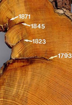
| Supplemental Information | STUDY NOTES: This site was chosen to correspond with alluvial-stratigraphy fire history sampling locations. ABSTRACT SUPPLIED BY ORIGINATOR: In the past few decades, wildfires have increased in size and severity in the Southwest and across the western US. These recent trends in fire behavior are a drastic change in arid, ponderosa pine and mixed conifer forests of the Southwest compared with tree-ring records of fire history for the past ~ 400 years. This study presents a late Holocene record (~ 3,000 years) of fire history and related changes in fire regimes with climate variability over annual to multi-decadal time scales. Tree-ring and alluvial-sediment sampling sites were paired in four small, tributary basins located in the western San Juan Mountains of Colorado. In our study sites, tree-ring records show that fire return intervals were longer and fire behavior was more severe on the north-facing slopes with relatively dense mixed conifer stands. Increased fire barriers and steep topography decreased the fire frequency and extent relative to gentle terrain elsewhere in the range and leading to a lack of synchrony among fire years in different parts of the study area. The alluvial-sediment record showed four peaks in high-severity fire activity over the past 3,000 years ranging between 200 - 400 years in length. The timing of peaks coincided with decadal-length drought episodes and were often preceded by multiple decades of above average winter precipitation. The sampling of alluvial-sediment and tree-ring data allowed for site-level comparisons between recent alluvial deposits and specific fire years interpreted from the tree-ring records. We found good correspondence between the type of fire-related sediment deposit (i.e. geomorphic response) in the alluvial record and the extent of mixed and high-severity fire estimated from the tree-ring record, and the correspondence was well-supported by the debris flow probability model results. The two paleofire data tend to represent particular components of the historical fire regime, with alluvial-sediments biased towards infrequent, high-severity events during recent millennia, and the tree-ring record biased toward lower severity fires during recent centuries. The combined analyses of different paleofire proxy types in the same study sites, therefore, can enhance and expand our understanding of fire and climate history beyond what is possible with either proxy alone. |
| Purpose | Records of past fire occurrence from tree rings, charcoal found in lake sediments, and other proxies. Parameter keywords describe what was measured in this dataset. Additional summary information can be found in the abstracts of papers listed in the dataset citations. Additional information on the International Multiproxy Database (IMPD) dataset procedures are also available. |
| Dataset Citation |
|
| Cited Authors |
|
| Originators |
|
| Publishers |
|
| Theme keywords |
Global Change Master Directory (GCMD) Science Keywords
|
| Data Center keywords |
Global Change Master Directory (GCMD) Data Center Keywords
|
| Place keywords |
|
| Use Constraints |
|
| Access Constraints |
|
| Fees |
|
Last Modified: 2024-01-30
For questions about the information on this page, please email: ncei.info@noaa.gov
For questions about the information on this page, please email: ncei.info@noaa.gov