NOAA/WDS Paleoclimatology - Mundo fire data from Desembocadura Río Mitre, Patagonia - IMPD ARMIT001
 Paleoclimatology - Fire History
This archived Paleoclimatology Study is available from the NOAA National Centers for Environmental Information (NCEI), under the World Data Service (WDS) for Paleoclimatology. The associated NCEI study type is Fire. The data include parameters of fire history|tree ring with a geographic location of Santa Cruz, Argentina. The time period coverage is from 82 to -61 in calendar years before present (BP). See metadata information for parameter and study location details. Please cite this study when using the data.
Dataset Citation
- Cite as: Mundo, I.A.; Villalba, R.; Veblen, T.T.; Kitzberger, T.; Holz, A.; Paritsis, J.; Ripalta, A. (2017-09-01): NOAA/WDS Paleoclimatology - Mundo fire data from Desembocadura Río Mitre, Patagonia - IMPD ARMIT001. [indicate subset used]. NOAA National Centers for Environmental Information. https://doi.org/10.25921/k7kp-pw08. Accessed [date].
- Please refer to Credit tab for full citation information.
Dataset Identifiers
- doi:10.25921/k7kp-pw08
- noaa-fire-22517
- NCEI DSI 1200_02
- NCEI DSI 1200_01
ISO 19115-2 Metadata
noaa-fire-22517
| Search Data |
|
| Download Data |
|
| Distribution Formats |
|
| Ordering Instructions | Contact NCEI for other distribution options and instructions. |
| Distributor |
NOAA National Centers for Environmental Information ncei.info@noaa.gov |
| Dataset Point of Contact |
NOAA National Centers for Environmental Information ncei.info@noaa.gov |
| Dataset Point of Contact | Data Center Contact NOAA World Data Service for Paleoclimatology 828-271-4800 paleo@noaa.gov |
| Coverage Description | Date Range: 1868 CE to 2011 CE; Date Range: 82 cal yr BP to -61 cal yr BP; |
| Time Period | 1868 to 2011 |
| Spatial Bounding Box Coordinates |
West: -72.78094
East: -72.78094
South: -50.44739
North: -50.44739
|
| Spatial Coverage Map |
| General Documentation |
|
| Associated Resources |
|
| Publication Dates |
|
| Data Presentation Form | Digital table - digital representation of facts or figures systematically displayed, especially in columns |
| Dataset Progress Status | Complete - production of the data has been completed |
| Data Update Frequency | Data update frequency not available |
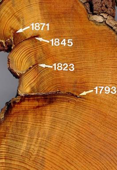
| Supplemental Information | ABSTRACT SUPPLIED BY ORIGINATOR: Fire is a major disturbance affecting forests worldwide with significant economic, social and ecological impacts. The southernmost forests on Earth extend continuously along the Andes from mid- to subantarctic latitudes in South America. In this region, warming and drying trends since the mid-20th century have been linked to a positive trend in the Southern Annual Mode (SAM), the leading mode of extratropical climate variability in the Southern Hemisphere. Due to the scarcity of documentary fire records and the lack of tree-ring fire histories, little is known about how wildfire activity responds to shifts in the westerly circulation pattern and associated climatic variability in the Andean region south of c. 44°S. For the first time, we applied dendrochronological techniques to reconstruct fire history from the angiosperm Nothofagus pumilio at 16 sites distributed from c. 44 to 50oS to determine relationships between fire occurrence and the two primary drivers of wildfire activity: climate variability and human activities. Partial cross-sections with fire-scars were collected from 363 trees in Argentina and Chile. Chronologies of annually resolved fire-scar dates start in 1791 and show a pattern of higher fire frequency during the 20th century, concurrent with the human occupation and colonization processes in southern Patagonia. Years of widespread fire occurring synchronously in two or more disjunct sites are associated with broad-scale climatic anomalies. Intense droughts inferred from extreme departures in temperature, precipitation and the Standardized Precipitation-Evapotranspiration Index (SPEI) during the growing seasons of 1944 and 1962 are consistent with the two most severe fires at northern sites. Extended droughts, reflected by the association of fire occurrence with 6-month cumulative precipitation and SPEI, create conditions for widespread fires at the southern sites (south of c. 46°S). Regional fires were concurrent with significant positive departures of SAM during the austral spring-summer. This tree-ring fire record reveals the influences of both climate variability and human activities on fire in the N. pumilio forests across the Andes, and also establishes the feasibility of using this tree species as a natural archive of fire history. |
| Purpose | Records of past fire occurrence from tree rings, charcoal found in lake sediments, and other proxies. Parameter keywords describe what was measured in this dataset. Additional summary information can be found in the abstracts of papers listed in the dataset citations. Additional information on the International Multiproxy Database (IMPD) dataset procedures are also available. |
| Dataset Citation |
|
| Cited Authors |
|
| Originators |
|
| Publishers |
|
| Theme keywords |
Global Change Master Directory (GCMD) Science Keywords
|
| Data Center keywords |
Global Change Master Directory (GCMD) Data Center Keywords
|
| Place keywords |
|
| Use Constraints |
|
| Access Constraints |
|
| Fees |
|
Last Modified: 2024-03-19
For questions about the information on this page, please email: ncei.info@noaa.gov
For questions about the information on this page, please email: ncei.info@noaa.gov