NOAA/WDS Paleoclimatology - Heyerdahl fire data from Leef's Hill, Palouse northwestern United States - IMPD USLFH001
 Paleoclimatology - Fire History
This archived Paleoclimatology Study is available from the NOAA National Centers for Environmental Information (NCEI), under the World Data Service (WDS) for Paleoclimatology. The associated NCEI study type is Fire. The data include parameters of fire history|tree ring with a geographic location of Idaho, United States Of America. The time period coverage is from 429 to -42 in calendar years before present (BP). See metadata information for parameter and study location details. Please cite this study when using the data.
Dataset Citation
- Cite as: Heyerdahl, E.K.; Morgan, P. (2019-10-15): NOAA/WDS Paleoclimatology - Heyerdahl fire data from Leef's Hill, Palouse northwestern United States - IMPD USLFH001. [indicate subset used]. NOAA National Centers for Environmental Information. https://doi.org/10.25921/mmgk-6e33. Accessed [date].
- Please refer to Credit tab for full citation information.
Dataset Identifiers
- doi:10.25921/mmgk-6e33
- noaa-fire-28042
- NCEI DSI 1200_02
- NCEI DSI 1200_01
ISO 19115-2 Metadata
noaa-fire-28042
| Search Data |
|
| Download Data |
|
| Distribution Formats |
|
| Ordering Instructions | Contact NCEI for other distribution options and instructions. |
| Distributor |
NOAA National Centers for Environmental Information ncei.info@noaa.gov |
| Dataset Point of Contact |
NOAA National Centers for Environmental Information ncei.info@noaa.gov |
| Dataset Point of Contact | Data Center Contact NOAA World Data Service for Paleoclimatology 828-271-4800 paleo@noaa.gov |
| Coverage Description | Date Range: 1521 CE to 1992 CE; Date Range: 429 cal yr BP to -42 cal yr BP; |
| Time Period | 1521 to 1992 |
| Spatial Bounding Box Coordinates |
West: -116.72934
East: -116.72934
South: 46.86683
North: 46.86683
|
| Spatial Coverage Map |
| General Documentation |
|
| Associated Resources |
|
| Publication Dates |
|
| Data Presentation Form | Digital table - digital representation of facts or figures systematically displayed, especially in columns |
| Dataset Progress Status | Complete - production of the data has been completed |
| Data Update Frequency | Data update frequency not available |
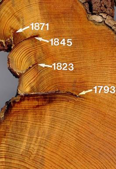
| Supplemental Information | STUDY NOTES: This site was sampled as part of a project to reconstruct historical fire regimes on the eastern edge of the Palouse Prairie-forest ecotone in Idaho. Ring-boundary fire scars were assigned to the preceding calendar year. Several metadata files are provided with the FHX file. -999 in any file indicates no data. https://www.ncei.noaa.gov/pub/data/paleo/firehistory/firescar/northamerica/supplemental/uslfh001-lfh-tree-info.csv provides information about the fire-scarred trees, e.g., species and location. The samples from this site were collected by Liesl Peterson as part of her senior thesis which is provided in https://www.ncei.noaa.gov/pub/data/paleo/firehistory/firescar/northamerica/supplemental/usbsh001-uslfh001-peterson-thesis.pdf. Sampled in the University of Idaho Experimental Forest ABSTRACT SUPPLIED BY ORIGINATOR: Prairie-forest ecotones are ecologically important for biodiversity and ecological processes. While these ecotones cover small areas, their sharp gradients in land cover promote rich ecological interaction and high conservation value. Our objective was to understand how historical and current fire occurrences and human development influenced the Palouse Prairie-forest ecotone. We used General Land Office survey field notes about the occurrence of bearing trees to locate historical (1870s to 1880s) prairie, pine savanna, and forest at the eastern edge of the bioregion. We combined LANDFIRE Existing Vegetation classes to contrast historical land cover with current land cover. We reconstructed historical fire occurrence (1650 to 1900) from fire-scarred trees. We used fire and lightning records from 1992 to 2015 to interpret the role of people and lightning. Historically, the ecotone was a matrix of prairie with some pine savanna and forest (72%, 16%, and 12% of GLO points, respectively). The prairie and pine savanna have been largely converted to agriculture, perennial vegetation under the Conservation Reserve Program, or residential development while the forest has not been converted. Fires were historically frequent, occurring on average every 5 to 8 years at most sites. Lightning was not frequent but could likely have been sufficient to ignite fires that could spread readily given the rolling terrain and long fire season. Fire was far more frequent historically than currently. Lightning and people may ignite fires that spread readily in the future as conservation, restoration, and other land-use changes result in more continuous vegetation and hence fuel for fires. Understanding the past and potential future of fire in the Palouse Prairie bioregion may help us live with fire while conserving ecological values here and in similar prairie-forest ecotones. |
| Purpose | Records of past fire occurrence from tree rings, charcoal found in lake sediments, and other proxies. Parameter keywords describe what was measured in this dataset. Additional summary information can be found in the abstracts of papers listed in the dataset citations. Additional information on the International Multiproxy Database (IMPD) dataset procedures are also available. |
| Dataset Citation |
|
| Cited Authors |
|
| Originators |
|
| Publishers |
|
| Theme keywords |
Global Change Master Directory (GCMD) Science Keywords
|
| Data Center keywords |
Global Change Master Directory (GCMD) Data Center Keywords
|
| Place keywords |
|
| Use Constraints |
|
| Access Constraints |
|
| Fees |
|
Last Modified: 2024-01-30
For questions about the information on this page, please email: ncei.info@noaa.gov
For questions about the information on this page, please email: ncei.info@noaa.gov