NOAA/WDS Paleoclimatology - Dune Lake, Alaska 12,000 Year Multiproxy Sediment Data
 Paleoclimatology - Lake
This archived Paleoclimatology Study is available from the NOAA National Centers for Environmental Information (NCEI), under the World Data Service (WDS) for Paleoclimatology. The associated NCEI study type is Lake. The data include parameters of paleolimnology with a geographic location of Alaska, United States Of America. The time period coverage is from 11326 to -42 in calendar years before present (BP). See metadata information for parameter and study location details. Please cite this study when using the data.
Dataset Citation
- Cite as: Finney, B.P.; Bigelow, N.H.; Barber, V.A.; Edwards, M.E. (2012-06-30): NOAA/WDS Paleoclimatology - Dune Lake, Alaska 12,000 Year Multiproxy Sediment Data. [indicate subset used]. NOAA National Centers for Environmental Information. https://doi.org/10.25921/d0g7-3v22. Accessed [date].
- Please refer to Credit tab for full citation information.
Dataset Identifiers
- doi:10.25921/d0g7-3v22
- noaa-lake-13076
- NCEI DSI 1200_02
- NCEI DSI 1200_01
ISO 19115-2 Metadata
noaa-lake-13076
| Search Data |
|
| Download Data |
|
| Distribution Formats |
|
| Ordering Instructions | Contact NCEI for other distribution options and instructions. |
| Distributor |
NOAA National Centers for Environmental Information ncei.info@noaa.gov |
| Dataset Point of Contact |
NOAA National Centers for Environmental Information ncei.info@noaa.gov |
| Dataset Point of Contact | Data Center Contact NOAA World Data Service for Paleoclimatology 828-271-4800 paleo@noaa.gov |
| Coverage Description | Date Range: 11326 cal yr BP to -42 cal yr BP; |
| Time Period | -9376 to 1992 |
| Spatial Bounding Box Coordinates |
West: -149.9
East: -149.9
South: 64.42
North: 64.42
|
| Spatial Coverage Map |
| General Documentation |
|
| Associated Resources |
|
| Publication Dates |
|
| Data Presentation Form | Digital table - digital representation of facts or figures systematically displayed, especially in columns |
| Dataset Progress Status | Complete - production of the data has been completed |
| Data Update Frequency | Data update frequency not available |
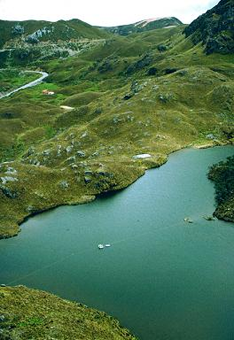
| Supplemental Information | STUDY NOTES: Multiproxy sediment data from Dune Lake, Alaska, for the past 12,000 years. Dune Lake is a shallow, closed basin, groundwater-fed lake located in the boreal forest of central Alaska. Paleoenvironmental proxies measured include Opal, organic C and N contents, and organic d13C and d15N stable isotopes. ABSTRACT SUPPLIED BY ORIGINATOR: Opal, organic C and N contents, and organic d13C and d15N stable isotopes were analyzed on a sedimentary sequence spanning the past ~12,000 years from Dune Lake, a shallow groundwater-fed lake in the boreal forest region of central interior Alaska. The chronology, based on 210Pb and 15 AMS radiocarbon dates on terrestrial materials, indicates that 5 m of biogenic sediment accumulated following dune stabilization at ~10,000 cal yr BP. Previous studies on lake level and pollen were synthesized with these data to assess Holocene changes in hydrogeology and climate. Variability in groundwater level and flux has a strong control on lake level and are negatively correlated with the d13C of organic matter produced within the lake. This relationship results from the input of groundwater with high pCO2 and with dissolved inorganic carbon depleted in 13C, which subsequently affects lake phytoplankton d13C signatures. A rapid rise in lake level between ca. 11,000 and 9,500 cal yr BP coincided with stabilization of the dune field adjacent to the lake and expansion of vegetation around the lake, including white spruce. Organic d13C values are relatively low and constant between about 10,000 and 6,000 cal yr BP, and then steadily increase until about 2,000 cal yr BP, suggesting a pattern of high followed by dropping lake levels generally consistent with results from core-transect studies. Higher-frequency fluctuations of 2–3 ‰ in d13C are common, and suggest variability in aspects of the lake-carbon cycle over multi-decadal timescales. Recent trends in groundwater and lake level, river discharge, and precipitation suggest an important role for wintertime precipitation in the regional groundwater system. The unusual hydrology of this system relative to most other lakes studied for paleoclimate in this region provides a novel insight into different seasonal aspects of Alaskan paleoclimatology. The record is consistent with a general long-term decrease in wintertime precipitation, possibly accompanied by an increase in permafrost extent, over the Holocene. |
| Purpose | Records of past climate and environment derived from lake sediment records. Parameter keywords describe what was measured in this dataset. Additional summary information can be found in the abstracts of papers listed in the dataset citations. |
| Dataset Citation |
|
| Cited Authors |
|
| Originators |
|
| Publishers |
|
| Theme keywords |
Global Change Master Directory (GCMD) Science Keywords
|
| Data Center keywords |
Global Change Master Directory (GCMD) Data Center Keywords
|
| Place keywords |
|
| Use Constraints |
|
| Access Constraints |
|
| Fees |
|
Last Modified: 2024-02-16
For questions about the information on this page, please email: ncei.info@noaa.gov
For questions about the information on this page, please email: ncei.info@noaa.gov