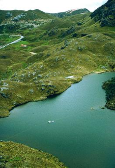
NOAA/WDS Paleoclimatology - Scoop Lake, South Greenland 3000 Year Chironomid d18O and Temperature
 Paleoclimatology - Lake
This archived Paleoclimatology Study is available from the NOAA National Centers for Environmental Information (NCEI), under the World Data Service (WDS) for Paleoclimatology. The associated NCEI study type is Lake. The data include parameters of climate reconstructions|paleolimnology with a geographic location of Greenland. The time period coverage is from 2782 to -66 in calendar years before present (BP). See metadata information for parameter and study location details. Please cite this study when using the data.
- Cite as: Lasher, G.E.; Axford, Y. (2019-02-11): NOAA/WDS Paleoclimatology - Scoop Lake, South Greenland 3000 Year Chironomid d18O and Temperature. [indicate subset used]. NOAA National Centers for Environmental Information. https://doi.org/10.25921/7hyg-vj96. Accessed [date].
- Please refer to Credit tab for full citation information.
| Search Data |
|
| Download Data |
|
| Distribution Formats |
|
| Ordering Instructions |
Contact NCEI for other distribution options and instructions. |
| Distributor |
NOAA National Centers for Environmental Information
ncei.info@noaa.gov
|
| Dataset Point of Contact |
NOAA National Centers for Environmental Information
ncei.info@noaa.gov
|
| Dataset Point of Contact |
Data Center Contact
NOAA World Data Service for Paleoclimatology
828-271-4800
paleo@noaa.gov
|
| Coverage Description |
Date Range: 2782 cal yr BP to -66 cal yr BP; |
| Time Period |
-832 to 2016 |
| Spatial Bounding Box Coordinates |
West: -45.419
East: -45.419
South: 60.697
North: 60.697
|
| Spatial Coverage Map |
|
| General Documentation |
|
| Associated Resources |
- Medieval warmth confirmed at the Norse Eastern Settlement in Greenland
-
Associated Reference published 2019
Lasher, G.E., Axford, Y., 2019: Medieval warmth confirmed at the Norse Eastern Settlement in Greenland. Geology, 47, 267-270, 10.1130/G45833.1
|
| Publication Dates |
|
| Data Presentation Form |
Digital table - digital representation of facts or figures systematically displayed, especially in columns
|
| Dataset Progress Status |
Complete - production of the data has been completed |
| Data Update Frequency |
Data update frequency not available |
| Supplemental Information |
STUDY NOTES: Oxygen isotope record measured on chironomid head capsule macrofossils. Paleo lake water is inferred from chironomid d18O values. Provided Keywords: Paleolimnology, Paleoclimatology, Greenland, Stable isotopes, Chironomids, Norse
ABSTRACT SUPPLIED BY ORIGINATOR: Recent work has documented glacier advances in West Greenland coincident with the Medieval Climate Anomaly (MCA) and warmth across much of northern Europe. The North Atlantic Oscillation (NAO) has been invoked to explain antiphasing of temperatures between these North Atlantic regions. Historical and model observations suggest negative correlation between the mode of NAO and both temperature and d18O values of precipitation over much of Greenland. We test for a hypothesized positive NAO mode and associated cool conditions during the MCA in South Greenland within the Norse Eastern Settlement by reconstructing d18O values of precipitation at subcentennial resolution over the past 3000 yr using aquatic insect subfossils preserved in lake sediments. More positive d18O values are found between 900 and 1400 CE, indicating a period of warmth in South Greenland superimposed on late Holocene insolation-forced Neoglacial cooling, and thus not supporting a positive NAO anomaly during the MCA. Highly variable d18O values record an unstable climate at the end of the MCA, preceding Norse abandonment of Greenland. The spatial pattern of paleoclimate in this region supports proposals that North Atlantic subpolar ocean currents modulated South Greenland's climate over the past 3000 yr, particularly during the MCA. Terrestrial climate in the Labrador Sea and Baffin Bay regions may be spatially heterogeneous on centennial time scales due in part to the influence of the subpolar gyre. |
| Purpose |
Records of past climate and environment derived from lake sediment records. Parameter keywords describe what was measured in this dataset. Additional summary information can be found in the abstracts of papers listed in the dataset citations. |
| Dataset Citation |
- Cite as: Lasher, G.E.; Axford, Y. (2019-02-11): NOAA/WDS Paleoclimatology - Scoop Lake, South Greenland 3000 Year Chironomid d18O and Temperature. [indicate subset used]. NOAA National Centers for Environmental Information. https://doi.org/10.25921/7hyg-vj96. Accessed [date].
- Please cite original publication, online resource, dataset and publication DOIs (where available), and date accessed when using downloaded data. If there is no publication information, please cite investigator, title, online resource, and date accessed. The appearance of external links associated with a dataset does not constitute endorsement by the Department of Commerce/National Oceanic and Atmospheric Administration of external Web sites or the information, products or services contained therein. For other than authorized activities, the Department of Commerce/NOAA does not exercise any editorial control over the information you may find at these locations. These links are provided consistent with the stated purpose of this Department of Commerce/NOAA Web site.
|
| Cited Authors |
|
| Originators |
|
| Publishers |
- NOAA National Centers for Environmental Information
|
| Theme keywords |
Global Change Master Directory (GCMD) Science Keywords- Earth Science > Climate Indicators > Paleoclimate Indicators > Ocean/Lake Records
Global Change Master Directory (GCMD) Science Keywords
- earth science > paleoclimate > climate reconstructions|paleolimnology
- earth science > paleoclimate > climate reconstructions|paleolimnology
- earth science > paleoclimate > climate reconstructions|paleolimnology
- earth science > paleoclimate > paleolimnology
- earth science > paleoclimate > climate reconstructions|paleolimnology
- earth science > paleoclimate > climate reconstructions|paleolimnology
- earth science > paleoclimate > climate reconstructions|paleolimnology
- earth science > paleoclimate > paleolimnology
- earth science > paleoclimate > climate reconstructions|paleolimnology
- earth science > paleoclimate > climate reconstructions|paleolimnology
- earth science > paleoclimate > climate reconstructions|paleolimnology
- earth science > paleoclimate > climate reconstructions|paleolimnology
- earth science > paleoclimate > paleolimnology > oxygen isotopes
Paleoenvironmental Standard Terms (PaST) Thesaurus
- What: temperature; Material: delta 18O
- What: temperature; Material: delta 18O
- What: temperature; Material: delta 18O
- What: delta 18O; Material: midge
- What: temperature; Material: delta 18O
- What: temperature; Material: delta 18O
- What: age; Material: null
- What: delta 18O; Material: midge
- What: delta 18O; Material: lake water
- What: depth; Material: null
- What: temperature; Material: delta 18O
- What: delta 18O; Material: lake water
|
| Data Center keywords |
Global Change Master Directory (GCMD) Data Center Keywords- DOC/NOAA/NESDIS/NCEI > National Centers for Environmental Information, NESDIS, NOAA, U.S. Department of Commerce
|
| Place keywords |
- Continent > North America > Greenland > Scoop Lake > LATITUDE 60.697 > LONGITUDE -45.419
|
| Use Constraints |
- Cite as: Lasher, G.E.; Axford, Y. (2019-02-11): NOAA/WDS Paleoclimatology - Scoop Lake, South Greenland 3000 Year Chironomid d18O and Temperature. [indicate subset used]. NOAA National Centers for Environmental Information. https://doi.org/10.25921/7hyg-vj96. Accessed [date].
- Use liability: NOAA and NCEI cannot provide any warranty as to the accuracy, reliability, or completeness of furnished data. Users assume responsibility to determine the usability of these data. The user is responsible for the results of any application of this data for other than its intended purpose.
- Please cite original publication, online resource, dataset and publication DOIs (where available), and date accessed when using downloaded data. If there is no publication information, please cite investigator, title, online resource, and date accessed. The appearance of external links associated with a dataset does not constitute endorsement by the Department of Commerce/National Oceanic and Atmospheric Administration of external Web sites or the information, products or services contained therein. For other than authorized activities, the Department of Commerce/NOAA does not exercise any editorial control over the information you may find at these locations. These links are provided consistent with the stated purpose of this Department of Commerce/NOAA Web site.
|
| Access Constraints |
- Distribution liability: NOAA and NCEI make no warranty, expressed or implied, regarding these data, nor does the fact of distribution constitute such a warranty. NOAA and NCEI cannot assume liability for any damages caused by any errors or omissions in these data. If appropriate, NCEI can only certify that the data it distributes are an authentic copy of the records that were accepted for inclusion in the NCEI archives.
|
| Fees |
- In most cases, electronic downloads of the data are free. However, fees may apply for custom orders, data certifications, copies of analog materials, and data distribution on physical media.
|
Last Modified: 2023-09-01
For questions about the information on this page, please email:
ncei.info@noaa.gov