Integrated Surface Dataset (Global)
Global Hourly; ISD
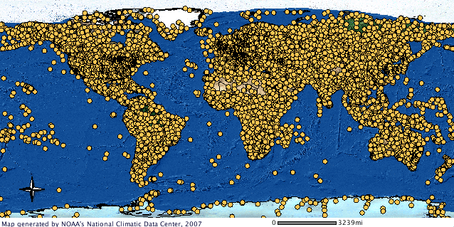 Integrated Surface Hourly GIS map
The Integrated Surface Dataset (ISD) is composed of worldwide surface weather observations from over 35,000 stations, though the best spatial coverage is evident in North America, Europe, Australia, and parts of Asia. Parameters included are: air quality, atmospheric pressure, atmospheric temperature/dew point, atmospheric winds, clouds, precipitation, ocean waves, tides and more. ISD refers to the data contained within the digital database as well as the format in which the hourly, synoptic (3-hourly), and daily weather observations are stored. The format conforms to Federal Information Processing Standards (FIPS). ISD provides hourly data that can be used in a wide range of climatological applications. For some stations, data may go as far back as 1901, though most data show a substantial increase in volume in the 1940s and again in the early 1970s. Currently, there are over 14,000 "active" stations updated daily in the database.
For user convenience, a subset of just the hourly data is available to users for download. It is referred to as Integrated Surface Global Hourly data, see associated download links for access to this subset.
- Cite as: NOAA National Centers for Environmental Information (2001): Global Surface Hourly [indicate subset used]. NOAA National Centers for Environmental Information. [access date]
- NCEI DSI 3505_02 (deprecated)
- NCEI DSI 3505_03
- gov.noaa.ncdc:C00532
| Search Data |
|
| Download Data |
|
| Distribution Formats |
|
| Ordering Instructions |
Contact NCEI for other distribution options and instructions. |
| Distributor |
NOAA National Centers for Environmental Information
ncei.info@noaa.gov
|
| Dataset Point of Contact |
Customer Engagement Branch
NOAA National Centers for Environmental Information
1-828-271-4800
ncei.orders@noaa.gov
|
| Time Period |
1901-01-01 to Present |
| Spatial Bounding Box Coordinates |
West: -180.0
East: 180.0
South: -90.0
North: 90.0
|
| Spatial Coverage Map |
|
| Publication Dates |
- publication: 2001
- revision: 2003
- revision: 2016
|
| Edition |
Version 2 |
| Data Presentation Form |
Digital table - digital representation of facts or figures systematically displayed, especially in columns
|
| Dataset Progress Status |
Ongoing - data is continually being updated |
| Data Update Frequency |
Daily |
| Purpose |
Integrated Surface Data provides a long-term record of hourly, sub-hourly and synoptic weather observations from station networks around the world. Observation sources include the World Meteorological Organization, Automated Surface Observing System, Automated Weather Observing Stations, US Climate Reference Network, and others. Weather elements observed include sky conditions, visibility, weather type, dry bulb, wet bulb, and dew point temperatures, relative humidity, wind speed and direction, wind gusts, station and sea level pressure, altimeter, and precipitation. Online data are typically delayed for 24 hours. |
| Dataset Citation |
- Cite as: NOAA National Centers for Environmental Information (2001): Global Surface Hourly [indicate subset used]. NOAA National Centers for Environmental Information. [access date]
|
| Cited Authors |
- User Engagement and Services Branch
DOC/NOAA/NESDIS/NCDC > National Climatic Data Center, NESDIS, NOAA, U.S. Department of Commerce
|
| Originators |
- User Engagement and Services Branch
DOC/NOAA/NESDIS/NCDC > National Climatic Data Center, NESDIS, NOAA, U.S. Department of Commerce
|
| Publishers |
- DOC/NOAA/NESDIS/NCEI > National Centers for Environmental Information, NESDIS, NOAA, U.S. Department of Commerce
- DOC/NOAA/NESDIS/NCDC > National Climatic Data Center, NESDIS, NOAA, U.S. Department of Commerce
|
| Theme keywords |
Global Change Master Directory (GCMD) Science Keywords
- Earth Science > Atmosphere > Air Quality > Smog
- Earth Science > Atmosphere > Air Quality > Tropospheric Ozone
- Earth Science > Atmosphere > Air Quality > Visibility
- Earth Science > Atmosphere > Altitude > Geopotential Height
- Earth Science > Atmosphere > Atmospheric Chemistry > Oxygen Compounds > Ozone
- Earth Science > Atmosphere > Atmospheric Electricity > Lightning
- Earth Science > Atmosphere > Weather Events > Tropical Cyclones
- Earth Science > Atmosphere > Weather Events > Drought
- Earth Science > Atmosphere > Weather Events > Fog
- Earth Science > Atmosphere > Weather Events > Freeze/Frost
- Earth Science > Atmosphere > Atmospheric Phenomena > Frost
- Earth Science > Human Dimensions > Natural Hazards > Tropical Cyclones > Hurricanes
- Earth Science > Atmosphere > Weather Events > Lightning
- Earth Science > Atmosphere > Weather Events > Rain Storms
- Earth Science > Atmosphere > Atmospheric Phenomena > Tornadoes
- Earth Science > Human Dimensions > Natural Hazards > Tropical Cyclones > Typhoons
- Earth Science > Atmosphere > Atmospheric Pressure > Anticyclones/Cyclones
- Earth Science > Atmosphere > Atmospheric Pressure > Atmospheric Pressure Measurements
- Earth Science > Atmosphere > Atmospheric Pressure > Pressure Tendency
- Earth Science > Atmosphere > Atmospheric Pressure > Pressure Thickness
- Earth Science > Atmosphere > Atmospheric Pressure > Sea Level Pressure
- Earth Science > Atmosphere > Atmospheric Pressure > Surface Pressure
- Earth Science > Atmosphere > Atmospheric Radiation > Sunshine
- Earth Science > Atmosphere > Atmospheric Temperature > Surface Temperature > Air Temperature
- Earth Science > Atmosphere > Atmospheric Temperature > Atmospheric Stability
- Earth Science > Atmosphere > Atmospheric Temperature > Surface Temperature > Maximum/Minimum Temperature
- Earth Science > Atmosphere > Atmospheric Temperature > Surface Temperature
- Earth Science > Atmosphere > Atmospheric Temperature > Surface Temperature > Temperature Tendency
- Earth Science > Atmosphere > Atmospheric Water Vapor > Water Vapor Indicators > Dew Point Temperature
- Earth Science > Atmosphere > Atmospheric Water Vapor > Water Vapor Processes > Evaporation
- Earth Science > Atmosphere > Atmospheric Water Vapor > Water Vapor Indicators > Humidity
- Earth Science > Atmosphere > Atmospheric Water Vapor > Water Vapor Tendency
- Earth Science > Atmosphere > Atmospheric Winds > Wind Dynamics > Convection
- Earth Science > Ocean > Ocean Winds > Convergence/Divergence
- Earth Science > Atmosphere > Atmospheric Winds > Surface Winds
- Earth Science > Atmosphere > Atmospheric Winds > Wind Dynamics > Turbulence
- Earth Science > Atmosphere > Atmospheric Winds > Upper Level Winds
- Earth Science > Atmosphere > Atmospheric Winds > Wind Dynamics > Vertical Wind Velocity/Speed
- Earth Science > Atmosphere > Atmospheric Winds > Wind Dynamics > Vorticity
- Earth Science > Atmosphere > Atmospheric Temperature > Atmospheric Temperature Indices > Wind Chill Index
- Earth Science > Atmosphere > Atmospheric Winds > Wind Dynamics > Wind Shear
- Earth Science > Atmosphere > Atmospheric Winds > Wind Tendency
- Earth Science > Atmosphere > Clouds > Cloud Properties > Cloud Amount/Frequency
- Earth Science > Atmosphere > Clouds > Cloud Properties > Cloud Ceiling
- Earth Science > Atmosphere > Clouds > Cloud Properties > Cloud Height
- Earth Science > Atmosphere > Clouds > Cloud Properties > Cloud Types
- Earth Science > Atmosphere > Clouds > Cloud Properties > Cloud Vertical Distribution
- Earth Science > Atmosphere > Precipitation > Liquid Precipitation > Rain > Freezing Rain
- Earth Science > Atmosphere > Precipitation > Solid Precipitation > Hail
- Earth Science > Atmosphere > Precipitation > Precipitation Amount
- Earth Science > Atmosphere > Precipitation > Precipitation Rate
- Earth Science > Atmosphere > Precipitation > Liquid Precipitation > Rain
- Earth Science > Atmosphere > Precipitation > Solid Precipitation > Ice Pellets > Sleet
- Earth Science > Atmosphere > Precipitation > Solid Precipitation > Snow
- Earth Science > Cryosphere > Sea Ice > Snow Depth
- Earth Science > Human Dimensions > Natural Hazards > Meteorological Hazards
- Earth Science > Terrestrial Hydrosphere > Snow/Ice > Snow Depth
- Earth Science > Terrestrial Hydrosphere > Surface Water > Surface Water Processes/Measurements > Floods
- Earth Science > Terrestrial Hydrosphere > Surface Water > Rivers/Streams
- Earth Science > Oceans > Ocean Waves > Wave Height
- Earth Science > Oceans > Ocean Waves > Wind Waves
- Earth Science > Oceans > Ocean Winds > Surface Winds
- Earth Science > Oceans > Tides > Storm Surge
- Earth Science > Oceans > Tides > Tidal Height
|
| Data Center keywords |
Global Change Master Directory (GCMD) Data Center Keywords
- DOC/NOAA/NESDIS/NCDC > National Climatic Data Center, NESDIS, NOAA, U.S. Department of Commerce
- DOC/NOAA/NESDIS/NCEI > National Centers for Environmental Information, NESDIS, NOAA, U.S. Department of Commerce
|
| Platform keywords |
Global Change Master Directory (GCMD) Platform Keywords
- Meteorological Stations
- Ground Stations
|
| Instrument keywords |
Global Change Master Directory (GCMD) Instrument Keywords
- Thermometers
- Rain Gauges
- Barometers
- Snow Measuring Rod
- Visual Observations
- Anemometers
- Wind Monitor
- Pressure Gauges
- Temperature Probes
- Wind Vanes
- Altimeters
- Gust Probes
|
| Place keywords |
Global Change Master Directory (GCMD) Location Keywords- Geographic Region > Global Land
|
| Stratum keywords |
Global Change Master Directory (GCMD) Location Keywords
- Vertical Location > Troposphere
- Vertical Location > Land Surface
- Vertical Location > Stratosphere
- Vertical Location > Sea Surface
|
| Use Constraints |
- Cite as: NOAA National Centers for Environmental Information (2001): Global Surface Hourly [indicate subset used]. NOAA National Centers for Environmental Information. [access date]
- Use liability: NOAA and NCEI cannot provide any warranty as to the accuracy, reliability, or completeness of furnished data. Users assume responsibility to determine the usability of these data. The user is responsible for the results of any application of this data for other than its intended purpose.
|
| Access Constraints |
- Distribution liability: NOAA and NCEI make no warranty, expressed or implied, regarding these data, nor does the fact of distribution constitute such a warranty. NOAA and NCEI cannot assume liability for any damages caused by any errors or omissions in these data. If appropriate, NCEI can only certify that the data it distributes are an authentic copy of the records that were accepted for inclusion in the NCEI archives.
|
| Fees |
- In most cases, electronic downloads of the data are free. However, fees may apply for custom orders, data certifications, copies of analog materials, and data distribution on physical media.
|
| Lineage information for: dataset |
|---|
| Lineage Statement |
The Integrated Surface Hourly Dataset is a merge of many observation streams to form a complete database of surface weather observations globally. Originally it was referred to as Integrated Surface Hourly Database (ISH), but has since grown to include data of various temporal periods (e.g., daily). The database holds data originating from sources such as the Automated Weather Network (AWN), the Global Telecommunications System (GTS), the Automated Surface Observing System (ASOS), and data keyed from paper forms. In addition, the database includes data originating from various codes such as synoptic, airways, METAR (Meteorological Routine Weather Report), and SMARS (Supplementary Marine Reporting Station), as well as observations from automatic weather stations. The data are sorted by station-year-month-day-hour-minute. Most digital observations are decoded either at operational centers and forwarded to the archive or one of its partners (including the US Air Force). Basic quality control may be performed prior to its arrival in the ISD database. For more information, please review documentation. |
| Processor |
- NOAA National Centers for Environmental Information (NCEI)
- NOAA National Centers for Environmental Information (NCEI)
- NOAA National Centers for Environmental Information (NCEI)
|
| Processing Steps |
- ISD Version 1 was released in 2001.
- ISD Version 2 was released in 2003 and included additional Quality Control Processing applied.
- In 2016, ISD received updated documentation and improvements to its processing, ensuring access to high, archive quality data.
|
| Source Datasets |
- NOAA Surface Weather Observations
-
NCEI Landing Page for NOAA-SWO
Source dataset landing page with general information and access links for that dataset.
- Description of Source: Source dataset for the product.
- Temporal extent used: 2004-02-28 to Present
- Spatial extent used: N:90 S:-90 E:180 W:-180
- United States Air Force 14th Weather Squadron Surface Weather Observations
-
NCEI Landing Page for USAF-SWO
Source dataset landing page with general information and access links for that dataset.
- Description of Source: Source Dataset is integrated daily with NOAA-SWO for completeness, extending the period of record.
- Temporal extent used: 1901-01-01 to Present
- Spatial extent used: N:90 S:-90 E:180 W:-180
- Static Inputs for the Integrated Surface Dataset
-
NCEI Landing Page for ISD Inputs
Source dataset landing page with general information and access links for that dataset.
- Description of Source: Several static datasets have been incorporated into ISD. Data are from Australia, Brazil, the Washington National Observatory, Greenland, Mexico, METAR Monthly Airways Extract (MAE), and the NSRDB.
- Temporal extent used: 1901-01-01 to Present
- Spatial extent used: N:90 S:-90 E:180 W:-180
|
| Lineage information for: repository |
|---|
| Processing Steps |
- 2015-04-22T00:00:00 - NOAA created the National Centers for Environmental Information (NCEI) by merging NOAA's National Climatic Data Center (NCDC), National Geophysical Data Center (NGDC), and National Oceanographic Data Center (NODC), including the National Coastal Data Development Center (NCDDC), per the Consolidated and Further Continuing Appropriations Act, 2015, Public Law 113-235. NCEI launched publicly on April 22, 2015.
|
| Acquisition Information (collection) |
|---|
| Instrument |
- AWS > AUTOMATED WEATHER SYSTEM
- ANEMOMETERS
- ALTIMETERS
- BAROMETERS
- CEILOMETERS
- HYGROMETERS
- HUMIDITY SENSORS
- PRESSURE SENSORS
- RAIN GAUGES
- TEMPERATURE SENSORS
- THERMOMETERS
- VISUAL OBSERVATIONS
- WIND VANES
- SUNSHINE RECORDERS
- ANEMOMETERS
- BAROMETERS
- HYGROMETERS
- RAIN GAUGES
- TEMPERATURE SENSORS
- THERMOMETERS
- VISUAL OBSERVATIONS
- WIND VANES
- ANEMOMETERS
- BAROMETERS
- TEMPERATURE SENSORS
- THERMOMETERS
- WIND VANES
|
| Platform |
- WEATHER STATIONS
- SHIPS
- BUOYS
|
Last Modified: 2023-08-10
For questions about the information on this page, please email:
ncei.info@noaa.gov