NOAA GOES-R Series Advanced Baseline Imager (ABI) Level 1b Radiances
ABI-L1b-Rad
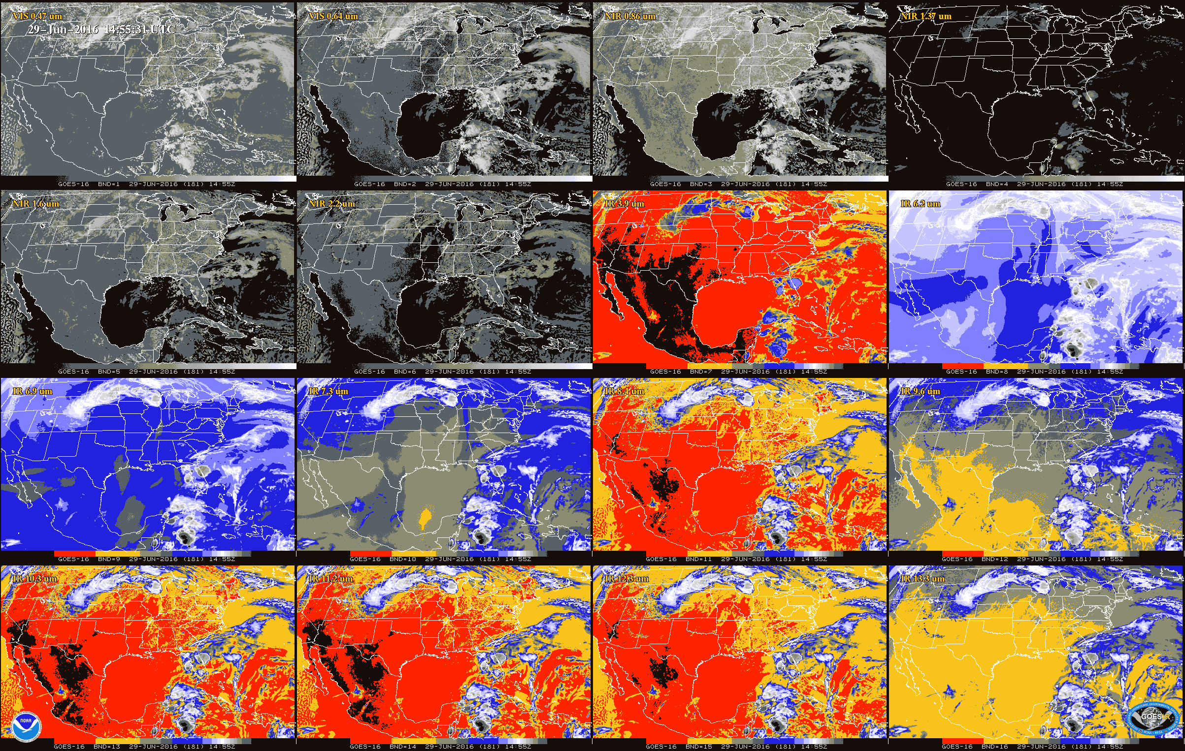 Example of ABI L1b data for each of the 16 bands.
The Advanced Baseline Imager (ABI) operates on board the NOAA Geostationary Operational Environmental Satellite-R (GOES-R) Series weather satellites providing advanced imagery and atmospheric measurements of Earth’s Western Hemisphere. The Advanced Baseline Imager (ABI) instrument samples the radiance of the Earth in sixteen spectral bands using several arrays of detectors in the instrument’s focal plane. Single reflective band ABI Level 1b Radiance Products (channels 1 - 6 with approximate center wavelengths 0.47, 0.64, 0.865, 1.378, 1.61, 2.25 microns, respectively) are digital maps of outgoing radiance values at the top of the atmosphere for visible and near-infrared (IR) bands. Single emissive band ABI L1b Radiance Products (channels 7 - 16 with approximate center wavelengths 3.9, 6.185, 6.95, 7.34, 8.5, 9.61, 10.35, 11.2, 12.3, 13.3 microns, respectively) are digital maps of outgoing radiance values at the top of the atmosphere for IR bands. Detector samples are compressed, packetized and down-linked to the ground station as Level 0 data for conversion to calibrated, geo-located pixels (Level 1b Radiance data). The detector samples are decompressed, radiometrically corrected, navigated and resampled onto an invariant output grid, referred to as the ABI fixed grid. There are three spatial coverage scenes per satellite (GOES East and GOES West): Full Disk is the full hemispheric view; Contiguous U.S. is the lower 48 states; and Mesoscale 1 and 2 are for weather event views.
Dataset Citation
- Cite as: GOES-R Calibration Working Group and GOES-R Series Program, (2017): NOAA GOES-R Series Advanced Baseline Imager (ABI) Level 1b Radiances. [indicate subset used]. NOAA National Centers for Environmental Information. doi:10.7289/V5BV7DSR. [access date].
Dataset Identifiers
- doi:10.7289/V5BV7DSR
- ABI-L1b-Rad
- gov.noaa.ncdc:C01501
- gov.noaa.class:GRABIPRD
ISO 19115-2 Metadata
gov.noaa.ncdc:C01501
| Download Data |
|
| Order Data |
|
| Distribution Formats |
|
| Ordering Instructions | Contact NCEI for other distribution options and instructions. |
| Distributor |
NOAA National Centers for Environmental Information ncei.info@noaa.gov |
| Dataset Point of Contact | Customer Engagement Branch DOC/NOAA/NESDIS/NCEI > National Centers for Environmental Information, NESDIS, NOAA, U.S. Department of Commerce ncei.sat.info@noaa.gov |
| Time Period | 2017-02-28 to Present (time interval: 10-minute) |
| Spatial Reference System | urn:ogc:def:crs:EPSG::4326 |
| Spatial Bounding Box Coordinates |
West: 141.7005
East: 6.2995
South: -81.3282
North: 81.3282
West: -156.2995
East: 6.2995
South: -81.3282
North: 81.3282
West: 141.7005
East: -55.7005
South: -81.3282
North: 81.3282
|
| Spatial Coverage Map |
| General Documentation |
|
| Processing Documents |
|
| Associated Resources |
|
| Publication Dates |
|
| Edition | Full Validation |
| Dataset Progress Status | Ongoing - data is continually being updated |
| Data Update Frequency | Continual |
| Purpose | Data provided by the 16 spectral channels are used to generate Level 2 and higher products, and are also used in numerical weather prediction models, aiding meteorologists and others in monitoring and predicting all kinds of weather and other phenomena. |
| Use Limitations |
|
| Dataset Citation |
|
| Cited Authors |
|
| Principal Investigators |
|
| Resource Providers |
|
| Publishers |
|
| Theme keywords |
Global Change Master Directory (GCMD) Science Keywords
|
| Data Center keywords |
Global Change Master Directory (GCMD) Data Center Keywords
|
| Platform keywords |
Global Change Master Directory (GCMD) Platform Keywords
|
| Instrument keywords |
Global Change Master Directory (GCMD) Instrument Keywords
|
| Place keywords |
Global Change Master Directory (GCMD) Location Keywords
|
| Project keywords |
Global Change Master Directory (GCMD) Project Keywords
|
| Data Resolution keywords |
Global Change Master Directory (GCMD) Horizontal Data Resolution Keywords
|
| Use Constraints |
|
| Access Constraints |
|
| Fees |
|
| Lineage information for: dataset | |
|---|---|
| Lineage Statement | These data were produced by the NOAA Office of Satellite and Product Operations (OSPO) and are archived at the NOAA National Centers for Environmental Information (NCEI). |
| Processor |
|
| Processing Steps |
|
| Processing Documents |
|
| Source Datasets |
|
| Lineage information for: repository | |
|---|---|
| Processing Steps |
|
Last Modified: 2023-09-18
For questions about the information on this page, please email: ncei.info@noaa.gov
For questions about the information on this page, please email: ncei.info@noaa.gov