NOAA/WDS Paleoclimatology - Lower Bear Lake, California 9170 Year Multiproxy Sediment Data
 Paleoclimatology - Lake
This archived Paleoclimatology Study is available from the NOAA National Centers for Environmental Information (NCEI), under the World Data Service (WDS) for Paleoclimatology. The associated NCEI study type is Lake. The data include parameters of paleolimnology with a geographic location of California, United States Of America. The time period coverage is from 9355 to 475 in calendar years before present (BP). See metadata information for parameter and study location details. Please cite this study when using the data.
Dataset Citation
- Cite as: Kirby, M.E.; Zimmerman, S.R.H.; Patterson, W.P.; Rivera, J.J. (2012-08-09): NOAA/WDS Paleoclimatology - Lower Bear Lake, California 9170 Year Multiproxy Sediment Data. [indicate subset used]. NOAA National Centers for Environmental Information. https://doi.org/10.25921/2f4e-j231. Accessed [date].
- Please refer to Credit tab for full citation information.
Dataset Identifiers
- doi:10.25921/2f4e-j231
- noaa-lake-13215
- NCEI DSI 1200_02
- NCEI DSI 1200_01
ISO 19115-2 Metadata
noaa-lake-13215
| Search Data |
|
| Download Data |
|
| Distribution Formats |
|
| Ordering Instructions | Contact NCEI for other distribution options and instructions. |
| Distributor |
NOAA National Centers for Environmental Information ncei.info@noaa.gov |
| Dataset Point of Contact |
NOAA National Centers for Environmental Information ncei.info@noaa.gov |
| Dataset Point of Contact | Data Center Contact NOAA World Data Service for Paleoclimatology 828-271-4800 paleo@noaa.gov |
| Coverage Description | Date Range: 9355 cal yr BP to 475 cal yr BP; |
| Time Period | -7405 to 1475 |
| Spatial Bounding Box Coordinates |
West: -116.914
East: -116.914
South: 34.254
North: 34.254
|
| Spatial Coverage Map |
| General Documentation |
|
| Associated Resources |
|
| Publication Dates |
|
| Data Presentation Form | Digital table - digital representation of facts or figures systematically displayed, especially in columns |
| Dataset Progress Status | Complete - production of the data has been completed |
| Data Update Frequency | Data update frequency not available |
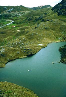
| Supplemental Information | STUDY NOTES: Multiproxy lake sediment data from Lower Bear Lake, California covering the last 9170 years. Parameters measured include magnetic susceptibility, LOI 550C, LOI 950C, ostracod counts, gastropod counts, and molar CN ratios. Lower Bear Lake was a small lake within Big Bear Valley prior to construction of Big Bear Dam in 1884 AD. Modern bathymetry reveals a distinct depression in the near-center of modern Big Bear Reservoir, representing the original Lower Bear Lake. A single drive, 4.5 m-long sediment core (BBLVC05-1) was extracted from Lower Bear Lake in 2005. The core was split, described, digitally photographed, and sub-sampled in the CSUF Paleoclimatology and Paleotsunami Laboratory. Mass magnetic susceptibility, LOI 550C (% total organic matter), and LOI 950C (% total carbonate) were determined at 1 cm contiguous intervals. Lower Bear Lake, California USA: 34.254°N, 116.914°W, 2059m elev ABSTRACT SUPPLIED BY ORIGINATOR: A well-dated, 9170 calendar year before present (cal yr BP) paleohydrologic reconstruction is presented from Lower Bear Lake in the San Bernardino Mountains of the coastal southwest United States. This new multi-proxy record is characterized by alternating organic-rich/carbonate-rich sediment units, interpreted to reflect hydrologically-forced changes in the lake's depositional environment. Our interpretation of the proxy data indicates nine decadal-to-multi-centennial pluvial episodes (PE) over the past 9170 cal yr BP. Of these nine inferred pluvials, five are interpreted as more pronounced based on their combined proxy interpretations: (PE-V) 9170?-8250, (PE-IV) 7000-6400, (PE-III) 3350-3000, (PE-II) 850-700, and (PE-I) 500-476 (top of core) cal yr BP. The Lower Bear Lake record indicates that the San Bernardino Mountains, source region for the Mojave River and its terminal playa, was wet during the same periods (within dating errors), to several of the major pluvials proposed from the lakes in the sink of the Mojave River. Our comparison extends north also to Tulare Lake, which drains the south-central western Sierra Nevada Mountains. This temporally and spatially coherent signal indicates that a similar climate forcing acted to increase regional wetness at various times during the past 9170 cal yr BP. As originally proposed by Enzel, Ely, and colleagues (e.g., Enzel et al., 1989; Enzel, 1992; Ely et al., 1994; Enzel and Wells, 1997), we too contend that Holocene pluvial episodes are associated with changing the frequency of large winter storms that track across a broad region at decadal-to-multicentennial timescales. We build upon their hypothesis through the addition of new and better-dated site comparisons, recent advances in the understanding of atmospheric rivers, and improved knowledge of the ocean-atmosphere dynamics that caused the early 20th century western United States pluvial. |
| Purpose | Records of past climate and environment derived from lake sediment records. Parameter keywords describe what was measured in this dataset. Additional summary information can be found in the abstracts of papers listed in the dataset citations. |
| Dataset Citation |
|
| Cited Authors |
|
| Originators |
|
| Publishers |
|
| Theme keywords |
Global Change Master Directory (GCMD) Science Keywords
|
| Data Center keywords |
Global Change Master Directory (GCMD) Data Center Keywords
|
| Place keywords |
|
| Use Constraints |
|
| Access Constraints |
|
| Fees |
|
Last Modified: 2024-03-15
For questions about the information on this page, please email: ncei.info@noaa.gov
For questions about the information on this page, please email: ncei.info@noaa.gov